About This Item
- Full TextFull Text(subscription required)
- Pay-Per-View PurchasePay-Per-View
Purchase Options Explain
Share This Item
The AAPG/Datapages Combined Publications Database
AAPG Bulletin
Abstract
Volume:
Issue:
First Page:
Last Page:
Title:
Author(s):
Abstract:
This paper is the result of observations made at intervals from 1921 to 1951 at Crater Mound, 20 miles west of Winslow, Arizona. The regional and the local studies of the geology furnished information which supports a geologic origin for Crater Mound.
Crater Mound occurs exactly on the axis of the large northwest-trending Sunshine Nose. The long axis of Crater Mound and the axis of Sunshine Nose both strike N. 8° W. A ring syncline with a drainage outlet toward the northeast lies outside and around the rim from ½ to 3/4 mile from the center of the crater. Within the mound, two grabens (down-faulted blocks) occur, one on the northwest, one on the southeast end, both part of a single large graben across the top of the crater. The graben pattern along with sink holes is common in the area. Also, the similarity of the Crater Mound graben to some of the graben on the faulted anticlines and domes in the Colorado Plateau is marked and suggests a possible genetic relationship.
The crater and the mound are two separate, though interrelated, geologic features. The present mound is the remnant or skeleton of an elliptical dome with a graben-like sink in its apex. Originally the dome was far higher, in the order of 1,000 feet or more above its present height. The blocks of Kaibab limestone and the Coconino sandstone which are found out of normal position above the Moenkopi redbeds fell from the overturned walls. Much of the white sand so prominent on the rim is laminated and bedded and is principally derived by weathering action from the sandy Kaibab limestone. The silica glass, lechatelierite, which occurs at Crater Mound is probably derived from old explosive volcanoes northwest or southwest of Crater Mound.
A tectonic-geomorphic origin is stressed. A deep-lying evaporite and limestone section was affected by waters infiltrating along the fault planes after the original folding and faulting occurred. Also, the disturbance of the regional water level by tectonic action accelerated subterranean erosion and stoping by solution with consequent subsidence.
A meteoritic shower occurred in the vicinity but it bears no visible relationship to the origin of the crater as the data prove that the crater was present before the meteoritic shower.
The folding is probably late Miocene or early Pliocene in age and of the order of 5,000,000 years, the crater of the order of 200,000 years or more, and the meteoritic fall that occurred in the vicinity considerably later of the order of 50,000-150,000 years.
End_Page 821------------------------------
Crater Mound, 20 miles west of Winslow, Arizona, was originally named "Coon Butte"; later, "Meteor Crater," "Crater Mound," and the Meteoritical Society now designates it "Barringer Meteorite Crater." Its official name designated by the U. S. Board of Geographic Names is "Meteor Crater." Numerous textbooks on geology and on astronomy feature it. Many popular and semi-scientific articles have been written about it, and many thousands of tourists annually view this natural wonder.
This discussion covers the relationship of Crater Mound to the regional geologic features, then to more localized features, and finally to close detailed mapping with plane table of Crater Mound.
The approach used was to let the geologic features at Crater Mound supply the answers, and consider the data without relation to prior studies. After completing the field data, tentative conclusions were compared with the findings of earlier workers--Daniel Moreau Barringer, Sr., the chief proponent of a meteoritic origin of the crater, and his co-workers, George P. Merrill and George Colvocorresses. G. K. Gilbert's and N. H. Darton's views were also reviewed.
Arguments of the meteoriticists and the geologists bear expansion but salient points only are discussed in this paper. Anyone desiring to pursue the subject further should consult the reference data at the end of this paper.
Meteoritic fragments occur around and on the rim of Crater Mound and some fragmental material has been found in the fill within the crater. The origin of the crater has been variously ascribed to the impact of a meteorite or to a meteoritic swarm which formed a hole in the earth. Early adherents of a meteoritic origin thought that the meteoritic body coming from the northwest buried itself deep in the earth, but when searching failed to find the buried body, it was then thought that the meteorite or meteoritic swarm exploded on impact and left a few fragments in the vicinity.
The late N. H. Darton and G. K. Gilbert first suggested the steam-explosion theory, i.e., that water in the lower sediments came in contact with a plutonic mass, generated a head of steam which blew out the sediments above, and left a giant crater. Several geologists, of whom the writer was one, proposed a fold and a sink-hole theory of origin as early as 1926. Such was the status of the problem until this present study was undertaken in the late 1940's.
Description of Crater Mound:
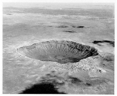
The aerial photograph of Crater Mound presents several interesting features (Fig. 1). Outside the crater rim one notes the rolling plain lying 120-150 feet below the rim. Inside the rim there is a deep, squarish depression without an outlet. The length of the sides is approximately 4,100 feet on top of the rim, but measured from the Moenkopi-Kaibab contact inside the rim the length of the sides is approximately 3,200 feet. The crater floor lies 615 feet below the highest point on the southwest corner of the rim, although 570 feet is the average depth.
The upper rim and walls incline inward with a 30° slope for 200 feet, at which point they fall very steeply for 150-200 feet and then slope more gently to the
End_Page 822------------------------------
central floor of the crater, which is a flat lake bed lying 330-350 feet below the general elevation of the plain around the mound.
Physiographically, the mound is an elevated hill rising above the plains with a deep hole in its top. Soft, white, cross-bedded, and laminated sand covers its flanks, but in places the sand is overlain by many limestone boulders, some of huge size. Smaller limestone boulders are strewn over both the inner and outer talus slopes of the mound, and comprise most of the talus on the slopes within the crater. Near the top, the inner walls beneath the mass of boulders and white sand consist of red siltstones, then gray to buff sandy limestone below, and beneath the limestone, brownish and gray sandstone (Fig. 10, columnar section). The present floor of the crater which is very flat at the center is an old fill, as shown by drill holes, with recent lake beds in the upper 200 feet. It also fo ms the top or roof of a hole which has been filled to a depth of nearly 900 feet with material derived from the walls.
Geologically, the mound and the crater are two distinct entities. The mound is distinctly a faulted dome with an eroded top with the strata in the walls generally
Click to view image in GIF format. Fig. 1. [Grey Scale]
End_Page 823------------------------------
dipping toward the surrounding plain. The crater occurs in the top of this dome.
Crater Mound (Fig. 2) occurs on the southwest rim of the Black Mesa Basin. Holes drilled for gas and oil, notably those on the Holbrook anticline, 35 miles southeast of Crater Mound, encountered evaporite beds including rock salt, totaling 300-700 feet in thickness in the Supai formation of Permian age. Other holes nearer the town of Holbrook also encountered such evaporites. Two holes northwest of Crater Mound, one 10 miles south of Cameron and one at the Gap, 50 miles north, failed to encounter evaporite beds. The beds there were like those in the Grand Canyon columnar section which lacks evaporite beds.
An area of sink holes lies south of the Holbrook anticline, and sink holes are also found on Chevelon Creek, 20 miles south of Winslow. This sink-hole area extends from 40 miles southeast of Crater Mound to beyond Cameron, which is 65 miles northwest of Crater Mound. Sink holes are also found in the Kaibab limestone near Flagstaff. Only 2 miles west of Crater Mound there is a line of sink holes in the Kaibab limestone, and sink holes occur in Canyon Diablo, 3 miles west of Crater Mound. Sink holes and graben are common features throughout an area more than 120 miles long and 20 miles wide (Fig. 2).
Volcanoes are found 25 miles northwest of the crater. More than 100 of these, according to Robinson (11), are of the explosive type. Some belong to the late Miocene period. This point is important in that volcanic material and some silica glass are found in and around Crater Mound and the most likely source is from the explosive volcanoes although another source might be sought on the southwest.
Sunset Mountain, 9 miles southeast of Crater Mound, was called a volcano by earlier workers but it is merely a mesa with 800 feet of Mesozoic sediments capped by a volcanic flow 200 feet thick. It should not be confused with Sunset Crater, northeast of Flagstaff, which is a recent volcano.
Sunshine Nose and Crater Mound:
In mapping Sunshine Nose and Crater Mound (Fig. 3) the contact between the red Moenkopi formation (Triassic) and the arenaceous Kaibab limestone (Permian) was used as the datum. Where absent, unless buried under talus, the basal Moenkopi beds above the contact were used with only slight error. Solid lines on the maps indicate actual conditions; dashed lines, inferred conditions. Elevations and the strike and dip readings were taken on the Moenkopi-Kaibab contact on the walls inside the crater rim.
Crater Mound occurs exactly on the axis of Sunshine Nose which strikes N. 8° W. (Fig. 3). This feature can be traced 15 miles and more farther southeast and as far northwest of Crater Mound. Sunshine Nose forms a shelf or platform and is but one of several similar features which occur northward to the Kaibab Plateau. Low doming occurs on those other features; none, however, as pronounced as at Crater Mound. In all of them, however, there is a flattening, then a similar abrupt accentuation of the dips eastward into the Black Mesa Basin.
Detailed map around Crater Mound:
The marked syncline around the Mound
End_Page 824------------------------------
Fig. 2. MAP OF PARTS OF ARIZONA NEW MEXICO UTAH & COLORADO SHOWING LOCATION OF WELLS & GENERAL GEOLOGIC FEATURES
End_Page 825------------------------------
(Fig. 4) is a feature not heretofore noted by earlier observers. The local anticlinal fold just west of the mound terminates in the low syncline on the north. The local anticlinal fold that curves eastward around Crater Mound terminates on the north in the northeast-plunging syncline although the main Sunshine Nose continues many miles northwest. It is pertinent here to compare this feature with the one shown on the aerial magnetic map made by the Fairchild Aerial Survey, Inc. (Fig. 5). The northeast opening of the syncline probably reflects an underground drainage around a buried landmass expressed by the east anticline.
The aerial magnetic map of the Fairchild Aerial Surveys, Inc. (Fig. 5), shows
Fig. 3. Contours on Top of Kaibab Limestone
End_Page 826------------------------------
Fig. 4. CRATER MOUND, ARIZ.
End_Page 827------------------------------
no magnetic anomaly in the crater. Such a lack suggests the absence of a basic plutonic mass, although some plutons are non-magnetic. The peculiar curving anticline east of Crater Mound shown in Figure 5 is believed caused by an old buried landmass, probably granite, since granite was found on the Holbrook anticline and several other folds at depths of 3,350-3,800 feet. The northern termination of this eastern mass coincides with a similar feature shown in Figure 4. The Fairchild map also shows a west-east anomaly which strikes toward Crater Mound and may reflect part of a deeply buried west-east fold which may have had a bearing on the origin of Crater Mound. The magnetic map, however, does not show the low anticlinal fold just west of Crater Mound (Fig. 4). This feature is considere secondary and due to subsidence, so that a magnetic anomaly would not occur. The small 10-gamma anomaly noted just south of the crater is due to machinery and to buildings at the drag-line cut which is shown in Figure 7. It is so weak that it could have been eliminated in contouring. Some interpreters think that this should have been done.
The low points and the high points around Crater Mound are shown in the cross sections (Fig. 6). These features, however, are better indicated by contours as they are scarcely apparent on the natural scale.
Fig. 5. AEROMAGNETIC CONTOUR MAP METEOR CRATER AND VICINITY
End_Page 828------------------------------
Fig. 6. W-E AND S-E CROSS SECTIONS TO SHOW MOUND & LOW POINTS AROUND IT
End_Page 829------------------------------
Two reconstructed arches are shown on cross sections (Fig. 6), one indicating a small sharp fold, the other showing a much wider fold. If the original folding started farther out, the present fold is a smaller collapsed feature. The wider fold could very well have been the original fold since features at Crater Mound are like some of the features investigated by Stokes (14) in the Colorado Plateau area of Colorado and Utah.
Faults at Crater Mound:
There are six large faults and one small fault in the rim of Crater Mound (Fig. 7). The northwest fault has a 50-foot vertical displacement, but the other faults have vertical displacements of 150 feet or more. The inward, horizontal movement of the downthrown faults for the northwest fault is 100 feet, for the large fault in the east wall, 150 feet, for the southeast fault, 200 feet, and for the southwest fault, 200 feet. Both the northwest and the southeast end blocks are graben and are considered merely the remnants of a single graben that once occupied the center of the fold, perhaps broken by cross faults connected with the faults shown in the east wall.
The main faults originally were probably large fractures with smaller initial vertical displacements than at present, but as solution and sinking continued, displacements increased. The present position of the faults is the result of both primary and of secondary action. The faults are not radial as has been stated in earlier works.
Graben are common features in area:
Graben are commonplace in the area. The faults encircling the Gray Mountain Nose (Fig. 8) are downthrown toward the mountain. The throws vary from a few feet to more than 500 feet. Graben extend across Gray Mountain Nose. Several of those graben are 300 feet deep. In the areas north and south of the Gray Mountain Nose one also finds graben and sinks (Fig. 8).
A drill hole south of the Gray Mountain Trading Post penetrated to a depth of 3,200 feet without encountering an evaporite section although it penetrated Redwall limestones below the Supai sandstone and shales, showing that the graben and sinks in that area were formed without an evaporite section underlying the area.
Harold V. Peterson of the U. S. Geological Survey at Salt Lake City climbed down an opening in the Kaibab limestone in one of the graben fractures. His statement throws much light on solution action.
Inspection of the solution cavities was made during an examination of the Waputki National Monument to determine the possibility of obtaining wells for wildlife within the Monument area. As there was no possibility of obtaining successful wells in the surface alluvium, attention was diverted toward the prospect of finding water in the Coconino sandstone.
When found in an unaltered state the (Kaibab) limestone rock is dense and impervious but the formation as a whole contains numerous openings in the form of joints, sink holes, fissures, and locally faults of small displacement. Some of these openings have been enlarged by solution until they are several feet across and openings two inches or more in width are common. One fault opening, located just south of the Monument boundary, is more than 100 feet long, wide enough to admit a man and is known to continue in depth through the limestone, well into the underlying Coconino sandstone. The Citadel sink and a similar sink located a few feet south of the Monument boundary are more than 100 feet across.
In many places the faults are marked by open fractures and on being told by one of the local
End_Page 830------------------------------
residents that he had climbed down for considerable distance, I decided to see if the openings extended to the Coconino. With the aid of a rope and using a flashlight I climbed down a distance estimated at about 100 feet. Both the hanging and footwalls were limestone. The fracture, although varying in width, was usually just wide enough to permit bracing myself against opposite walls.
The contact between the Kaibab and the Coconino was easily recognized not only because of difference in lithology, but also because the cavity widened to some 10 to 15 feet making it impossible to descend further. The cavity continued downward as far as I could see with the flashlight but because of wall irregularities this sight was limited to about 30 or 40 feet. Generally the cavity in the sandstone had rounded walls as though it had been formed by gradual removal of the cement in the rock, thus permitting loosening of individual sand grains. Because much of the sandstone consists of insoluble silica grains, I concluded that the solution must have been rather extensive in order to make room for the sand and still leave the large cavity observed.
The north-south cross section of the Gray Mountain Nose (Fig. 8) shows a surprising similarity to the cross sections at Crater Mound (Figs. 9 and 10). Such similarities seem too marked to be wholly coincidental. It is apparent that the graben found at Crater Mound is not unique as it fits into the general pattern for an area more than 100 miles long and 15-20 miles wide.
Former height of walls:
The arenaceous Kaibab limestone beds are found vertical to overturned at four places (Fig. 7). The steep beds flare outward from the crater for short distances. The dips of the flared beds measured toward the crater range from 70° to 80°. The steepness of these dips may have been due to inward sinking in deeper beds and not directly caused by folding as it is possible that the original fold extended much further out.
The large limestone blocks have fallen outward from the overturned beds. The large number of blocks present and the size of the talus slopes force the conclusion that the walls were at one time hundreds of feet higher. This greater height is supported by two other features.
1. Only a few fragments of Coconino sandstone--a brownish red member--have been found around the crater rim. The presence of even a few fragments of the first red Coconino member on the present rim indicates that a red Coconino bed must have risen well above the present rim in the center of the arch. There are 35 feet of Moenkopi redbeds on the rim, 280 feet of Kaibab limestone, and 180 feet of Coconino which must be penetrated before encountering the first red Coconino sandstone; thus, the arching must have been nearly 500 feet to bring the first red Coconino sandstone to the present height of the lowest part of the ends. Also, the beds were faulted downward from their original positions. To allow for such faulting another 500 feet would put the top of the arch approximately 1,000 fe t above the present rim. The height of the restored fold as measured from the restored syncline would be nearly 1,000 feet.
2. The vast quantity of white sand around the mound, most of which is derived from the white, sandy Kaibab limestone, indicates that the walls must have been very high to supply so much material. Also, vast quantities of this white sand must have been blown away. The Kaibab limestone is highly arenaceous, testing 15-40 per cent of fine white sand. It is possible that some of the sand was derived from highly arched Coconino beds on top of the dome, but the character of the sand under the microscope shows it to be mainly Kaibab.
End_Page 831------------------------------
Fig. 7. GEOLOGIC AND STRUCTURAL MAP OF CRATER MOUND
End_Page 832------------------------------
Fig. 7. Continued. See caption on page 832.
End_Page 833------------------------------
Fig. 8. STRUCTURE OF THE CAMERON-WUPATKI REGION
End_Page 834------------------------------
Fig. 8. Continued. See caption on page 834.
End_Page 835------------------------------
Fig. 9. NORTH-SOUTH CROSS SECTION THROUGH CENTER OF CRATER MOUND
End_Page 836------------------------------
Reconstruction of walls:
The fairly straight sides of the crater, both east and west between the points of high elevation, are noteworthy. This straightness is due to inward sinking of the walls. At the four corners, the side walls abut against the down-faulted graben which keep them from sinking farther inward, but in the center they lack such support and have sagged inward to form nearly straight lines.
The reconstructed outline of the walls (Fig. 7, XXX) is based on the Moenkopi-Kaibab contact. The shape is that of an elliptical domal fold with an eccentricity of 0.66. Expressed in another way the long axis, 4,800 feet in length, is approximately 1.27 times the short axis which is 3,800 feet in length. This long axis strikes N. 8° W., which coincides with the strike of the axis of Sunshine Nose.
The original fold may at one time have extended across the synclines. If so, the present fold with its broken and sunken top is the skeleton not only of a much higher feature, but also of a much wider feature which has gradually sunk downward and inward to its present form.
Holes drilled to find meteorite:
Holes were drilled to find the meteoritic body which was supposed to be buried at depth. In 1921 the United States Smelting, Refining, and Mining Company started drilling a hole on the south rim of the crater (Fig. 7) and attained a depth of 1,376 feet without encountering a solid meteoritic body. The hole was abandoned after spending more than $125,000 as the company officials felt that even if a meteorite were found, it presented a very difficult metallurgical problem; also the mining of a large, solid mass of nickel-iron at that time presented almost insuperable obstacles.
Twenty-eight test holes and several shafts have been drilled in the upper floor of the crater, but only nine out of twenty-eight drill holes are shown in Figure 7. The list of twenty holes in Table I, after George P. Merrill (8), is part of the basis for cross sections (Figs. 9 and 10). These holes and shafts are estimated to have cost more than $1,500,000.
Observations from cross sections:
In cross section (Fig. 10) a brown iron-stained Coconino sand occurs on the southeast rim of the crater and overlies the bedded white sand derived from the Kaibab. This sand is derived from the sharp-dipping to overturned topmost Coconino beds shown at the southeast corner of Crater Mound, and only 200 feet away, and not from deep down in the Coconino beds as reported by earlier observers.
While not shown on the writer's maps, alluvial fans are present near the steep overturned Kaibab beds. However, all but the northwest alluvial fans are found at points where the beds are overturned (Fig. 7). The beds at the northwest corner are not overturned and large limestone blocks are found there. The present position of the beds there is due to sinking after first being vertical or overturned, since at the four points where the beds are overturned large limestone blocks are prominent and clearly have fallen outward from the wall.
In the northwest graben large boulders are more numerous closer to the faults on the east and on the west sides than is the case at the middle of the
End_Page 837------------------------------
Fig. 10. WEST-EAST CROSS SECTION THROUGH CENTER CRATER MOUND
End_Page 838------------------------------
faulted segment. Most of the large boulders fell outward as the walls eroded but some fell into the graben at points nearest the high walls (Figs. 9 and 10).
Test hole of United States Smelting, Refining, and Mining Company:
The U. S. Smelting, Refining, and Mining Company's churn drill hole on the south rim (15) was drilled 1,376 feet, beginning in November, 1920, and completed in November, 1922, when it was abandoned because the drill was stuck by boulders. Evidence from this log indicates that the southeast wall settled on an earlier crater fill and that later fill has settled against the sunken wall (Figs. 7 and 9). The earlier fill continues farther south under the wall.
Nature of crater fill:
The upper 120 feet of the crater is comprised of stratified lake beds carrying recent fossils. Lake beds continue to 220 feet in depth. Beyond that depth the beds contain sand and boulders which are also stratified, an evidence of fill rather than a fall of material. The U. S. Smelting, Refining, and Mining Company log definitely indicates alternating layers of material, not a heterogenous mass, and even reports that shells 1/8 inch long occurred at 1,311-1,335 feet in depth. If these were fossil shells, it indicates lake bed sediments to that depth.
The gallery shown in the south wall (Fig. 9), extending through the talus and Coconino sandstone to the drill hole, was dug by the U. S. Smelting, Refining, and Mining Company to release underreamer lugs left in the hole. This gallery was driven 380 feet horizontally--the first 80 feet of it through talus, and 300 feet through the Coconino sandstone. The gallery was then turned upward 20 feet where the underreamer lugs were released, and drilling was continued. Several of Barringer's original core holes are also shown in this cross section.
Table I.
End_Page 839------------------------------
The U. S. Smelting, Refining, and Mining Company log is so important that it is presented in full.
LOG OF CHURN DRILL HOLE
By U. S. Smelting, Refining, and Mining Company.
L. F. I. Holland, superintendent to 326 feet.
C. W. Plumb, superintendent to 1,376 feet.
Drilling started, November, 1920.
Drilling completed, November, 1922.
Table
End_Page 840------------------------------
Table
The U. S. Smelting, Refining, and Mining Company drill hole, 1,376 feet deep, or 827 feet below the present crater floor, did not penetrate solid beds of gray, yellow, red, or orange-red, nor did it reach the white sand usually found above the solid beds. Small meteoritic iron fragments are mentioned throughout the lower part of this log. The white sand mentioned in other drill records just before entering the solid beds was deposited after sinking of the central blocks became stabilized. D. M. Barringer, Sr. (1, p. 15) mentions this white sand. (Italics are by Dorsey Hager.)
A fact of interest in this connection is that where the drill finds the meteoric material representing fusion of the projectile to be most plentiful in the depths of the crater, 600 and odd feet below the visible floor (between 1,100 and 1,200 feet below the original plain level), there is immediately underneath a bed of very white and very fine silica or rock flour, which, so far as we know, contains no meteoric material. Nor has any ever been found below it. This is certainly strongly opposed to the theory that there has been much oxidation of meteoric iron (shale ball iron or any other kind) in the depths of the crater, at least in its central portion. From this point down the drill encountered in all of the 23 holes sunk below this level more and more compact sandstone, until it p ssed into the absolutely unaltered lower portions of the white or gray sandstone and into the unaltered Red Beds stratum. In all 28 holes were drilled in the central portion of the crater and not less than 14 encountered this undoubted meteoric material at between 450 and 680 feet, the greatest depth at which it has been found. This was in hole No. 20. In a large majority of the holes it was found very sparsely distributed, and in a few of them more or less abundantly, but never, except in the hole above mentioned, forming more than a very small percentage of the fragmentary material brought up by the drill.
End_Page 841------------------------------
The Coconino redbeds shown in the U. S. Smelting, Refining, and Mining Company log at 172 feet below the top of the Coconino formation, have not heretofore been reported as occurring so high in the Coconino, although Barringer, Sr., does mention the occurrence of fragments of brownish red Coconino sandstone found on the rim (1, p. 2) but considers they came from deep in the crater.
In my paper read before the Academy of Natural Sciences of Philadelphia four years ago I made the mistake, owing to the similarity of color, of thinking that a portion of the Red Beds (Supai) had been thrown out. I now know that the brownish red fragments are from what we term the brown sandstone, above referred to, which overlies the Red Beds [Supai].
The lower alluvial fill in the U. S. Smelting, Refining, and Mining Company drill hole continues to the total depth of 1,376 feet where the whole was abandoned still in boulders. In this drill log, reference to boulders up to 6 inches in size is made in several places, but no mention is made of boulders of great size.
There are differences in elevations between the bottom of the fill in the U. S. Smelting, Refining, and Mining Company drill hole and those found in the dense lower beds reported in the earlier test holes drilled by Barringer. Such dense lower beds are both whitish, buff, and reddish in color, and are probably Coconino beds as the Supai beds are orange-red, and not easily confused with the Coconino beds. The presence of Coconino beds at such depths supports the sink theory.
The bottom layer of sediments containing meteoritic fragments also is not level. Barringer's statement (1) based on 23 wells shows that 680 feet was the depth of the deepest meteoritic material in the center of the crater and shows also that there is a difference of depths to which the holes penetrated the bed rock in the crater. The depth to solid bottom at the south end is not known as the U. S. Smelting, Refining, and Mining Company hole, 1,376 feet deep, penetrated only 827 feet below the present crater floor which is 262 feet less in depth below the crater floor than Barringer's deepest hole in the crater which encountered white sand before penetrating redbeds. However, in the U. S. Smelting, Refining, and Mining Company hole on the south rim meteoritic fragments were encountered 120 feet deeper than in any of the holes at the north, but the depth to dense, solid rock is not yet known in this hole. This hole lacks 258 feet of being as deep as hole No. 8 where redbeds were found at 900 feet, and solid cores were reported at 1,030 feet continuing solid to a total depth of 1,085 feet.
In hole No. 10 solid beds were reported at 745 feet below the upper crater floor, or 82 feet higher than the bottom of the U. S. Smelting, Refining, and Mining Company hole, which stopped 827 feet below the upper floor. The grayish sandstone bed at 745 feet is interpreted here as Coconino sandstone with red Coconino sandstone below it, another evidence for subsidence. Depressions occur around hole No. 8 and around the U. S. Smelting, Refining, and Mining Company churn drill hole.
Conditions on rim:
White laminated sand overlies the Moenkopi redbeds, both on the northeast and southeast rims. Also, there is a lack of large limestone boulders overlying the white sand on the southeast end, but such boulders are more plentiful on the northeast end and around the sides.
End_Page 842------------------------------
The northeast arch is almost as marked as the arch on the southeast. Its highest point of the Moenkopi-Kaibab contact is, however, 40 feet lower in elevation than the highest contact on the southeast arch.
The vertical throw of the northeast fault is 140 feet and the vertical throw of the northwest fault is 50 feet. However, the beds on the upthrown side of the northwest fault which now dips as high as 20° must, at one time, have been vertical to overturned as explained earlier. The beds in the northwest fault block have sunk not only downward but horizontally toward the crater as there is horizontal displacement from the rim toward the crater.
It is interesting to note the eroded Moenkopi surface on the north end as shown in cross section (Fig. 9). Large limestone blocks occur near the faults on the east and west and fewer occur near the center of the arch. The blocks found near the center clearly slid down from the more highly elevated walls both on the east and on the west. Although not shown on the maps and cross sections, the cut in the rim where the U. S. Smelting, Refining, and Mining Company drill hole was placed shows bedded sandstone and limestone fragments lying on the eroded Moenkopi surface.
The west-east cross section through the center of the crater (Fig. 10) also shows the white laminated sands found above the Moenkopi and below the boulders; also, it shows that the dips on the side walls along the Moenkopi-Kaibab contact are less than the dips below in the underlying Coconino beds. If one measures the thickness of the beds from the walls inward to the bottom redbeds, there would be a thickness of 1,200 feet of Coconino sandstone if the lower redbeds reached by the drill were really Supai. This is almost double the known thickness of the Coconino sandstone and is added evidence for subsidence since the gray, white, and yellowish beds reported in the drill holes (Table I) do not normally occur in the Supai formation, but such beds do belong to the Coconino formation and could only occupy such a position at depth by having sunk downward.
It is probable at one time the beds were even higher than the restored projection. It seems clear that the Moenkopi and Kaibab beds were completely eroded and also that part of the Coconino sandstone was partly eroded before the blocks sank to their present positions. Subsidence ended when the underground drainage was stabilized at which time the period of crater fill began.
The west-east cross section on the south end (Fig. 10) also shows an arched graben and two large faults with 150 feet vertical throw, one toward the east, one toward the west. Vertical to overturned Kaibab limestone beds are seen on the upthrown sides of the faults. The large Kaibab limestone blocks have fallen from the overturned beds and lie on the laminated white sand. There is a paucity of limestone blocks in the center of the arched end above the white sand, but on the east, brown Coconino sand overlies the fine white sand near the southeast fault. As explained earlier this brown sand comes from the sharp-dipping Coconino beds that abut against the fault only 200 feet away, but before erosion the beds were immediately adjacent.
End_Page 843------------------------------
Drag-line cut:
The drag-line cut and the barrow pits on the southeast end (Fig. 7) which are now being developed afford important geologic evidence. The drag-line cut begins on the rim and extends 600 feet south (Figs. 7 and 11). In places it has been scraped to the top of the underlying Moenkopi beds. Some of the sand is finely laminated, some irregularly bedded, but at no place well within or below the white sand does one find boulders of Kaibab limestone or massive Coconino sandstone boulders. According to any theory of explosion or of impact heavy boulders should be found beneath the white sand.
While this fine white sand is often called flour sand, only a part is flour-like. The screen analysis (Table II) after Buddhue (3) shows 34.01 per cent to be medium sand, 37.73 per cent to be fine sand, 12.79 per cent to be very fine sand, and the balance of 14.37 per cent to be under 200 mesh which also comprises 7.85 per cent under 400 mesh which is silt and flour sand.
If a steam explosion or an explosion caused by meteoritic impact occurred, it does not seem possible that the white and red sandstones, gray limestones, and red mudstones and shales, which must have been thrown upward, could have settled back as pure laminated white sand! The heavy boulders should have fallen first, but the only limestone boulders found contiguous to the drag-line cut are small ones which occur above the 25-35 feet of fine white laminated and bedded sand, clearly a sedimentary deposit derived from beds higher in the walls of the crater. Also, the only meteoritic iron so far found in excavating the drag-line cut was found on the edge of the cut on the south, buried 3 feet in the white sand with 25 feet of white sand beneath it! Similar white sand is found in the new ro d made in 1950 on the north segment of the rim shown in the photograph of Figure 1.
Table II. MECHANICAL ANALYSIS OF WHITE SAND
End_Page 844------------------------------
Any attempt to explain the fallen boulders and the white sand as due to impact carries beyond reasonable credence. Also, there seems to be no way to explain why a mass of crushed material of different colors should fall as a mass of fine, powdery, white sand, bedded and in many places laminated. Similar material is found all around the rim of the crater, and similar sand is also reported to be found at depth in holes drilled in the crater.
This white sand found in the drag-line cut and barrow pits and on the rim is principally derived from the fine white sand in the Kaibab limestone. Some of the fine white Kaibab sand from dissolved Kaibab limestone shows thin, delicate splinters under the microscope. Also, thin sections of the Kaibab limestone show fine thin fragments of less than .01 mm. in size embedded in the limestone. In the laminated and bedded material in the drag-line cut and in the barrow pits the similar fine splintery sand is broken or fractured, commonly at right angles to or diagonally across the splinters but the fine delicate splinters embedded in the limestone are not fractured. When freed from their support in the calcareous matrix, they would be readily broken and shattered due to rain, frost, or wind action.
The walls show no exceptional breakage or fracturing other than that due to normal weathering. Also there is no evidence of metamorphic action in the exposed beds.
Distribution of meteoritic fragments:
It is interesting to note the distribution of the meteoritic material found around Crater Mound. Barringer, Sr., used a radial distribution starting at the center of the crater with circles spaced at mile intervals on his map. His distribution without the circles is reproduced in Figure 12. The fragmental distribution with one exception (the most northeasterly) is Barringer's.
Fig. 11. SKETCH SECTION ALONG DRAGLINE CUT
End_Page 845------------------------------
It will be noted in Figure 12 that the largest fragments occur at the northeast. The large fragments are relatively scarce in an arc N. 10° E. to N. 30° W. from Crater Mound, the direction one would naturally assume the greatest concentration to be found if a meteorite came in from the northwest as postulated by the meteoriticists.
No meteoritic fragments are shown on Barringer's map in the upper part of the present crater, which is to be expected since under a geologic theory of origin the meteorite fell early in the history of the crater fill, and the meteoritic fragments that fell into the crater were covered by later fill. Some of those fragments which are reported in test holes evidently fell or were washed in from the rim, but some, as shown by the test holes, must have fallen into the partly filled crater which was formed prior to the meteoritic shower.
If it is assumed that the meteoritic materials were thrown out on impact, the heaviest fragments should be contiguous to the crater, but this is not the case. Some heavy fragments are found northeast of the crater 2-3 miles, but the heaviest one so far found occurred 6 miles northeast, while the fragments southwest of the crater are lighter. This fails to support a theory of impact but does give force to the argument that the meteorite struck to the northeast, broke into fragments which skipped and bounced mainly toward the southwest with a few pieces diverging from their initial direction to form erratic occurrences. The pattern instead of circular is roughly fan-like with the central line extending south of the crater. This fan-like distribution satisfies the occurrence of heavy fra ments better than a radial distribution.
A heavy concentration of small particles against the northeast side of the crater is shown in Figure 12. This would naturally be expected from an object striking from the northeast. Under this fan-like distribution some fragments must have bounced and rolled back off the walls of the mound, some should have rested on top the rim, and others went into, over, and around the mound. Barringer's following statement (1, pp. 10 and 11) bears out the surficial occurrence of the meteorite. (Italics are by Dorsey Hager.)
It is interesting that so far no piece of the ordinary unoxidizable Canyon Diablo iron has yet been found deeply embedded in the silica on the slopes of the mountain, but always on top of it, that is on or very near the surface, where many hundreds of specimens have been found. I have no completely satisfactory explanation to offer for this fact.
Again one of these large iron meteorites, with no shale surrounding it, was found slightly embedded, but with a point protruding, in the silica and rock fragments on the northeast slope of the mountain, and almost immediately beneath it within a few feet, there was found a large shale ball meteorite with a solid iron center. It is certain that neither had been moved appreciably since they came to rest in the silica and ejected rock fragments. Possibly these large, deeply pitted, and many of the small meteorites, both of which we know as ordinary Canyon Diablo siderites, were individual meteorites trailing behind the cluster.
It is quite possible that two meteoritic falls occurred as Barringer, Sr., mentions finding a single small aerolite (stony meteorite) which might have fallen in 1904-1905 (1). This stony meteorite strongly suggests a second meteoritic fall. However, Barringer is none too certain that the stony meteorite is not part of the same fall as the metallic fragments. Also, a stony meteorite of substantial
End_Page 846------------------------------
Fig. 12. CRATER MOUND, ARIZONA
End_Page 847------------------------------
size is found in the collection at the Field Museum in Chicago accredited to Meteor Crater. This piece is certainly not similar in any way to the nickel-iron meteoritic fragments. The two pieces of stony meteorite might well be fragments from a second fall. The following quotations from Barringer (1, pp. 13, 18-19, and 22) are pertinent. (Italics are by Dorsey Hager.)
It should be stated also that there is not the slightest evidence, either inside or outside of the crater, to warrant the conclusion that the projectile was composed of anything but nickel iron; unless the finding by me of a single small aerolite about one and one-half miles N.W. of the crater, several years ago, may be regarded as such. As stated in my former paper, there is fairly good reason to believe that this aerolite was seen to fall in the winter of 1904-5. It is recognized, however, that it may have been a member of the swarm, the central or probably the most advanced portion of which, when it struck the earth, was the projectile which made the crater, and which, from all evidence, was almost wholly composed of iron meteorites. From this point of view the finding of the aerol te lends support to the theory that the crater was made by a compact cluster of meteorites.
Also that some of the very small shale balls, now converted into hard, dense iron shale, have been found several miles from the crater. Therefore, as had been pointed out, it is practically certain that these were not ejected from the crater. The distance, in all probability, is too great. The fact that the large spurts or jets of white sandstone fragments are confined, practically speaking, to the northeast one-third of the crater rim, and the further fact that most of the shale balls which we have so far found embedded in the silica and rock fragments, have been found, so to speak, between these spurts, strongly suggest, as I am willing to admit, that some of the shale balls were thrown out of the crater at the time when the jets or spurts of white sandstone were squeezed out of it. It should also be remembered that it is certain that the shale balls do not owe their present globular shape to weathering in situ in the silica or in the soil on the outside plain. Any one who has dug them out of the almost snow white silica and observed the very small amount of concentric staining by which they are surrounded, does not need to be further convinced of this fact. The oxidation of the iron having proceeded equally fast from the outside inwardly, the present shape of the iron center is also conclusive proof that the original shape of the complete meteorite was not very dissimilar. From all of these facts and arguments it is highly probable, if not proved, that most of the so-called shale ball meteorites so far found fell out of the sky independently of the main mass or clu ter, and as separate individuals struck the earth at or within a few feet of the places where we now find them or their remains, and therefore had nothing whatever to do with the formation of the crater.
I still think it probable, however, that many, if not most, of the meteorites found in the uppermost layers of the debris, and all of those found on the open plain, fell directly from the sky, as stragglers following the main mass.
These statements of stragglers by Barringer show that in his opinion the fall of such meteoritic fragments had nothing to do with the formation of the crater.
For some unknown reason the impression is prevalent that a tremendous volume of meteoritic material was encountered at Crater Mound. The total amount of material so far picked up around Crater Mound is less than 25 tons. Barringer's statements indicate the volume of meteoritic material found in the drill holes was not large. Also, at the depth from 1,335 to 1,339 feet, the well log of the U. S. Smelting, Refining, and Mining Company shows that the sludge contained 75 per cent of nickel-iron. However, careful reading of that log indicates that the nickel-iron reaction while very good at places was found within limited ranges.
The observations of Barringer, Sr., all point to the fact that the meteoritic material fell after the fine white sand had been formed and that such a fall must have occurred in a relatively short time, seconds probably, minutes at most. There is no mention of the sand being bedded and laminated, which as any geologist knows requires seasons, years, and centuries--not seconds and minutes! Nor would the impact of a meteoritic body, which penetrated 1,400 feet deep through
End_Page 848------------------------------
beds of brown, red, white, and gray rock, result in fine snowy white sand. The logical conclusion from present evidence is that the meteoritic fall was thousands of years later than the formation of the crater.
Early geologic hypotheses of Crater Mound:
Several geologic hypotheses of origin were considered before settling on one.
1. The gas explosion hypothesis championed by N. H. Darton (4) but first mentioned by G. K. Gilbert (5) was one of the first geologic hypotheses. Darton and Gilbert's steam-explosion hypothesis would be tenable if it were in accord with the geologic data. It, however, fails to explain the geologic features around the crater and for that reason is unsatisfactory. As shown throughout this discussion there is no support for explosive action of any kind.
2. The sink-hole hypothesis mentioned by Gilbert (5) and by the writer. Gilbert's simple sink-hole origin for the crater does not explain the domal form of the mound or its relation to Sunshine Nose. In 1926 the writer advocated a sink-hole hypothesis for the crater and recognized that it was on top of a dome of some sort, but at that time had done no detailed work on the problem. It seemed then that the sink holes on Chevelon Creek and also south of the Holbrook anticline, southeast of Crater Mound, had some bearing on the problem.
3. The salt-dome hypothesis with subsequent subsidence due to solution of salt beds. Such a hypothesis of origin is quite possible as salt beds should underlie the area, and a salt mass may have forced the beds upward to form a domal fold, and then later solution of the salt mass caused subsidence of the beds above it. This would also explain the ring syncline, and satisfies most of the geologic data. The salt-dome hypothesis has been given serious consideration, but the Gray Mountain Nose with its marked graben features occurs in an area where an evaporite section is absent, so that a salt-dome hypothesis is not necessary to account for the sink features. However, a salt-dome hypothesis for Crater Mound can not be readily dismissed.
4. The plutonic-plug hypothesis for the origin was considered. A mass of hot igneous rock pushed upward and elevated the overlying beds. Hot magmatic waters caused solution action. Stoping may also have taken place. Sinking of the plutonic mass could have caused subsidence of the overlying beds, similar to a caldera. Such a hypothesis is not incompatible with present geologic features. Magnetic surveys, however, fail to support the presence of a plutonic mass beneath the crater, but the presence of igneous activity only 25 miles away affords some support for the plutonic hypothesis.
None of the hypotheses mentioned satisfies the conditions as fully as what is designated here as the tectonic-geomorphic hypothesis. This hypothesis fits in well with the faulting pattern in the area, with the faults at Crater Mound, and with sinks in the area, some only two miles west. Also, subsidence has caused sinks and land slides with step faulting on the southwest slope of the Holbrook anticline, 40 miles southeast of Crater Mound. Erosion has also caused well developed sink holes in the Coconino sandstone just east of Chevelon Creek, 20
End_Page 849------------------------------
miles south of Winslow and 25 miles southeast of Crater Mound. A belt of graben and sink holes continues beyond Cameron, 60 miles northwest of Crater Mound.
In drilling on the Holbrook anticline the Coconino sandstone was found so fractured and cavernous that circulation could not be maintained in the two rotary holes drilled jointly by the Continental Oil Company and the Union Oil Company of California, and also circulation was lost numerous times in drilling the Supai beds which indicates that the beds were very porous.
Subsidence is due to sinks in the Coconino sandstone as well as in the underlying beds. Solution in an evaporite section in the Supai beds beneath the Coconino sandstone and in the deeper limestones would be sufficient to account for subsidence. As W. L. Stokes points out (14), solution caused subsidences from 2,000 to 5,000 feet in the graben in the Colorado Plateau area of Colorado and southeastern Utah where such graben occur on well defined anticlines domes which are underlain by evaporite beds of the Paradox formation of Pennsylvanian age.
Suggested origin of crater:
In discussing the origin of Crater Mound it is well to consider the probable buried landmass just east of the crater (Fig. 5), which could have acted as a focal point for the tectonic forces which caused an uplift of the beds. At the same time that arching occurred, fault breaks or large fractures formed in the top of the fold. Infiltration of surface waters to the lower section into the underlying evaporites and also into the lower limestone beds followed down the faults and the fractures. Such water dissolved the deeper beds thus causing the overlying beds to sink.
Erosion also planed off 800 feet or more of Triassic beds capped by lava. Such a section of beds occurs 9 miles southeast at Sunset Peak and is also found west of Crater Mound. About 280 feet of sandy Kaibab limestone and probably several hundred feet or more of upper Coconino sandstone were also eroded. Most of this early rock material disappeared long before the present detrital material was formed and before subsidence became pronounced. This accounts for the lack of Kaibab limestone in the deep section within the crater as such rock was eroded from the top before subsidence took place.
The upward tilting of the beds also caused some rotation and crushing of sands along the lines of original faulting which might account for some of the crushed sand, although weather effects probably account for most of the fine "shattered" grains.
Folding action merely set the stage for the subterranean erosion and solution stoping. Also the regional tilting of the Black Mesa Basin upset the regional hydrostatic equilibrium and accelerated underground drainage and erosion. This theory is supported at present by the very low hydrostatic heads found in the test holes drilled for gas and oil in the Holbrook area and by the numerous sink holes and graben found in the area.
Stoping due to underground solution started in the limestone beds and gradually affected the Supai beds and then continued upward. Water also infiltrated
End_Page 850------------------------------
down the fault planes and assisted in the solution action and in the actual removal of rock material. Continued subterranean action caused the top of the dome to break into blocks which settled downward to finally reach a state of equilibrium on the lower floor of the crater after subterranean action ceased. Evidence exists from sink holes both in sandstones and in limestones at many other places away from Arizona to justify a sink of the proportion found here.
An interesting example of a sink hole in sandstone is the Montlake sink (13) in Hamilton County, Tennessee. It is 300 feet in diameter and over 800 feet in depth. The sink hole starts in a conglomerate 125 feet thick which is underlain by 700 feet of shales and sandstone before reaching a limestone which is 350 feet in thickness. Many other examples of large sink holes and calderas can be cited.
Age of Crater Mound:
A thickness of 600-800 feet of sediments capped by 100 feet or more of a basalt flow normally covered the beds now exposed at Crater Mound. This material had to be eroded before the lower Moenkopi, Kaibab, and Coconino beds were exposed.
This overlying material helps to date the age of the ancient mound and crater as at least 800 feet of section had to be removed before there could be any erosion of the underlying beds. Removal at the high rate of one foot in 2,500 years demands nearly 2 million years before the Moenkopi beds were reduced to 35 feet on top of the fold. Even after the upper 800 feet of capping beds were carried away, a considerable thickness of 500 feet, more or less, of sandy Kaibab limestone and Coconino sandstone had to be eroded. Subterranean erosion in the crater only stopped when the fault blocks sank to the point where subterranean erosion had ceased. Then the present crater fill commenced. However, the period of subsidence must have occupied a very long time.
The erosion of the 800 feet of overlying material plus the erosion of the Kaibab limestone and the Coconino beds, make it appear that the age of the mound can hardly be less than 5,000,000 years, and probably much older.
Blackwelder (2) and others estimate that fossils in the upper 200 feet of lake beds in the present fill are 20,000-50,000 years in age. This estimate does not take into account the lower alluvial fill 900 feet thick in the crater which may have required a hundred thousand years or more to accumulate. Such lower beds have heretofore been considered to have fallen in the crater immediately after meteoritic impact but the drill-hole records indicate a layer-like or bedded arrangement; hence, such beds were washed in which required many thousand years.
The mound then is in the measure of 5,000,000 years or more while the present crater fill is in the measure of 100,000 or 150,000 years. The original domal fold was late Tertiary, probably late Miocene or early Pliocene time, and the crater was also formed during the Pliocene. The fill is late Pliocene to Recent.
When the meteoritic fall occurred some fragments penetrated the already formed crater and fell on 20-80 feet of white sand which at that time laid on the bottom of the crater and which also occurred around the crater's rim. This dates the meteoritic fall perhaps as early as 50,000-150,000 years ago.
End_Page 851------------------------------
Negative features do not sustain meteoritic hypotheses:
The lack of important features is commonly strong evidence against the happening of an event. Even if one grants for the moment the possibility of meteoritic impact, one of the features difficult to explain is the lack of the orange-red Supai sandstone around the rim of the crater. A thickness of at least 500 feet of Supai beds should have been blown out of the crater if the meteoritic hypothesis were correct, but no Supai fragments are found. Also, if the Supai material were pulverized, it should be mixed with the fine white sand, but such is not the case.
If there had been meteoritic impact, where are the altered Moenkopi siltstones? Where are the evidences of mineralized Kaibab limestones which have a high silica content? Where, also, are the evidences of altered Supai sandstones?
The silica glass, lechatelierite, supposedly representing the altered Coconino, is relatively small in volume and is not widely dispersed. Most of this glass is distinctly pumiceous; in fact, it can only be identified under the microscope as silica glass. It is not a glassy mass like the fused fulguritic glass caused when lightning strikes sandstone. Flow lines and pores due to gas or aeration cause its pumiceous aspect. Some of it has been welded like some pumice ashes. Such alteration is reported only for the Coconino sandstone, yet the Moenkopi and the Kaibab beds occur above the Coconino, and the Supai beds lie beneath and were in direct line of impact action. No shred of evidence show any alteration in the siliceous Kaibab limestone or in the red mudstones of the Moenkopi, and no Supai beds with minerals derived from impact are present. Certainly such beds should have been metamorphosed and unusual minerals developed from meteoritic impact.
Mineralogists claim that the time element is a feature and that an instantaneous flash is too short to develop unusual minerals that only form with time, but that silica glass can be instantly formed. However, cristobalite and tridymite occur with some of the silica glass and such crystalline forms required time for their formation.
Much stress is laid by meteoriticists upon the presence of silica glass as evidence for impact at Crater Mound. Barringer (1), Merrill (8, 9), and Rogers (12) who describe this glass in detail assume it to be formed by the intense heat of meteoritic impact. It is claimed that this silica glass is a product of alteration of Coconino sandstone at Crater Mound. However, it could from its nature have originated from deeper sandstones, even quartzites found in Proterozoic beds far removed from Crater Mound. Most of the silica glass material in and around the crater gives every appearance of volcanic ejecta. Finely laminated pieces of silica glass found in the lake beds in the crater have undoubtedly been formed by secondary action from fine ashy material either washed in from the sides of he crater or deposited by wind. Also, the opalescent material present with some of the silica glass is the effect of local aqueous action.
Some of the larger blocks of the light, frothy form of silica glass which show little lamination are either direct ejecta from volcanoes, or they may be the product
End_Page 852------------------------------
of a natural welding process of volcanic pumice composed of silica glass similar to welded types found in other volcanic pumices. Silica glass has been found in volcanic rocks. Explosive volcanoes northwest and southwest penetrated large thicknesses of Coconino and other sandstones, and such volcanoes are only 25-40 miles distant from Crater Mound.
Statements have been made that volcanic material could not be ejected such distances from a volcanic crater. Records, however, show that large blocks of volcanic material were thrown 17 miles high at Krakatoa, and as far horizontally as 54 kilometers, nearly 32.5 miles. Blocks at Krakatoa of 30-50 tons in weight were thrown 2-3 miles inland. This is not known to be the maximum.
Volcanic ash may be carried thousands of miles. The very porous silica glass found at Crater Mound is even lighter than most pumiceous ash.
The claim is made by Barringer (1) that the staining of the vesicular glassy material by nickel is proof of its formation by meteoritic impact. However, most of the large fragments are not stained, but staining is likely where silica glass comes in contact with meteoritic material.
Probable source of silica glass:
The source of the silica glass may possibly be in the Flagstaff area or it may occur from some source on the southwest. Much of the Flagstaff area is covered by recent flows so that a search must be made below those flows for the pure silica glass. The source of this glass is an interesting point for future research. It is interesting to note that field work for this study made in the Flagstaff area uncovered rhyolitic glass in places beneath the recent flows, but so far no pure silica glass has been found.
Pellicles of nickel-iron:
Nininger (10) reports finding very small particles or pellicles of meteoritic material on the rim and around the crater in the upper part of the fine white sand, in some places coating the sand. Such material would naturally be expected if a local meteoritic shower took place, or if a meteorite struck in the vicinity. Not only meteoritic dust would be present, but also hot fused particles would coat the sand. The fact that the occurrence is in the upper part of the sand substantiates a meteoritic fall later than the deposition of the sand on the rim. Pellicles of meteoritic dust are also reported by oceanographers in their dredging operations and are apparently common occurrences with meteoritic showers.
Geophysical results to date uncertain:
Magnetic and electrical methods used at Crater Mound have so far failed to find marked anomalies to prove the presence of a meteoritic mass. Jakosky (6), Lundberg (7), Whelan, and Fairchild Aerial Surveys, Inc., all mapped the area. Jakosky found an electrical-resistivity anomaly that was tested with negative results. Lundberg is reported to have located several places outside the crater that showed anomalies, but Whelan's work did not check with either Jakosky or Lundberg. The results of the Fairchild Aerial Surveys, Inc., were noted earlier. Magnetic studies also failed to outline a deep-seated anomaly which could be ascribed to a plutonic mass. However, some acid and also some basic igneous rocks have little or no effect upon the magnetic
End_Page 853------------------------------
needle, so the lack of an anomaly does not entirely rule out a plutonic mass.
The maps of Crater Mound presented in this discussion were made with the plane table and alidade. Flags were used to mark triangulation points. Checking the orientation of the flagged points with the magnetic needle showed no variation in the needle. Magnetic needles on alidades, however, are not as sensitive as on magnetometers.
Other geophysical methods should be tried. A gravimetric survey might be useful. Also, by employing a seismograph and using a refraction pattern, anomalies might be mapped which would go far to determine the presence or absence of a plutonic mass or of highly folded older beds, although under the tectonic-geomorphic hypothesis such a mass is not needed to explain Crater Mound.
SUMMARY
This study has brought out the following new features.
1. Crater Mound lies exactly on the axis of Sunshine Nose, a large structural nose in the area.
2. The reconstructed northwest axis of Crater Mound coincides with the axis of Sunshine Nose.
3. There is a ring syncline around the crater with a drainage area toward the northeast that coincides remarkably with an aerial magnetic feature interpreted as an underground granitic mass.
4. Crater Mound occurs in an area probably underlain by an evaporite section not heretofore recognized.
5. Crater Mound occurs in an area where graben and sink holes are common features.
6. The northwest and southeast ends of Crater Mound are graben, probably part of a larger feature that occupied the crater.
7. The square shape of the crater is a secondary feature due to inward sinking of the walls.
8. The present walls are only the roots of a far larger and more pronounced domal fold than has heretofore been considered.
These eight features are definite. The four following statements are open to debate.
9. The present crater has reached its size and shape due to subterranean action (solution and erosion) with consequent subsidence of fault blocks as the result of solution.
10. The fold is probably a very old one of late Miocene or early Pliocene age, measured in millions rather than in thousands of years.
11. The crater is probably a much younger feature measured in hundreds of thousands of years.
12. A meteoritic fall occurred in the vicinity of, but not directly in, the crater, perhaps 50,000-150,000 years ago, but had no connection with the origin of the crater, and meteoritic fragments probably fanned out from a point of impact several miles northeast of the already formed crater.
End_Page 854------------------------------
CONCLUSION
It might be more conservative to accept the theory of multiple hypotheses for the origin of Crater Mound, but the data point strongly to one type of geologic origin. It is quite apparent from the data that explosive actions, whether from meteoritic impact as advocated by the meteoriticists or from steam explosion as advocated by Darton and Gilbert, are not tenable. Several geologic hypotheses besides the tectonic-geomorphic hypothesis of origin advocated in this paper were considered and discarded because they failed to satisfy geologic conditions. However, some other geologic hypothesis may yet be found that will supply a better answer than the one advocated in this paper.
It is surprising that so many obvious geologic facts have been so long overlooked. However, new data especially in the barrow pits, the drag-line cut, and the new road cuts have thrown much new light on the subject. Other points not seen by earlier observers, or if seen and interpreted as proof of a meteoritic origin, can be better considered as proof of a geologic origin. At every step in this investigation new evidence for a geologic origin has been found, and none for a meteoritic origin. The cumulative evidence for a geologic origin seems to be overwhelming.
A clear answer to this problem would be obtained by drilling a series of holes to a good datum outside and within the crater. If such a datum showed a folded condition in the deepest beds penetrated in the crater, then a geologic origin would be definitely established.
Pay-Per-View Purchase Options
The article is available through a document delivery service. Explain these Purchase Options.
| Watermarked PDF Document: $14 | |
| Open PDF Document: $24 |
AAPG Member?
Please login with your Member username and password.
Members of AAPG receive access to the full AAPG Bulletin Archives as part of their membership. For more information, contact the AAPG Membership Department at [email protected].