About This Item
- Full TextFull Text(subscription required)
- Pay-Per-View PurchasePay-Per-View
Purchase Options Explain
Share This Item
The AAPG/Datapages Combined Publications Database
AAPG Bulletin
Abstract
Volume:
Issue:
First Page:
Last Page:
Title:
Author(s):
Abstract:
The Misener Sandstone of north-central Oklahoma comprises a somewhat discontinuous sandstone-carbonate rock sequence which is commonly less than 20 ft. thick. It covers a large northwest-southeast-trending belt and produces some oil and gas. The Misener is overlain by, and grades upward into, the Woodford Shale and appears to represent an early phase of Woodford deposition in central Oklahoma. The Misener-Woodford sequence unconformably truncates the underlying Hunton Group, Sylvan Shale, Viola Limestone, and Simpson Group. The Misener conodont faunas range in age from late Middle to Late Devonian (Givetian to early Famennian). This indicates that the Misener is correlative with part of the Woodford Shale in the Arbuckle Mountain region of southern Oklahoma and with the o der part of the Sylamore Sandstone in northern Arkansas. The Misener is composed in large part of rounded, detrital quartz grains set in a matrix of crystalline dolomite, grading into crystalline dolomite with scattered quartz grains. It is interpreted as a diachronous marine deposit laid down near an old shoreline formed by the partly emergent Hunton strata. Its detrital quartz is inferred to have been derived in large part from Simpson sands that were swept westward by an advancing sea. The Misener also forms a smaller belt in Marshall County, south-central Oklahoma, but there the detrital quartz is angular and includes considerable mica. The detritus in this rock appears to have been subjected to relatively little abrasion, suggesting close proximity to the source area.
Text:
INTRODUCTION
The Misener is a quartz sandstone-carbonate sequence which is widely distributed over central and northern Oklahoma (Figs. 1, 2). Misener oil and gas production has been reported over a considerable area in central and north-central Oklahoma. The present study is part of a subsurface investigation by Amsden on middle Paleozoic strata in the western two thirds of Oklahoma, and it therefore includes only that part of the state extending from R10E westward to the Oklahoma and Texas panhandles.
The Misener was named after Fred D. Misener, a Tulsa oil operator, for a sandstone found at a depth of 3,009-3,054 ft in the No. 1 McWilliams well, Sec. 23, T15N, R10E, Creek County, Oklahoma (see Wilmarth, 1938, p. 1385). According to Jordan (1957, p. 133), the name first appeared in an article by White and Greene (1924, p. 42), who applied the name to a light-blue, slightly calcareous shale[?] distributed over an area extending from Okmulgee County to Osage County. The stratigraphic relations were not discussed; however, a generalized stratigraphic diagram accompanying the article showed the Chattanooga (Woodford) Shale lying on Misener and truncating it and the St. Clair Limestone (equivalent to Quarry Mountain, Tenkiller, and Blackgum Formations: Amsden and Rowland, 1965, p. 7) an older strata. A few years later White (1926, p. 21-23) again discussed the Misener, concluding that it represented a windblown sand which formed on the pre-Chattanooga erosion surface. He correlated the Misener with the Sylamore Sandstone of eastern Oklahoma (Amsden, 1961, p. 61-68, Pl. 13), which is interpreted as a marine beach sand. The Chattanooga (Woodford), Misener, and Sylamore were assigned an Early Mississippian age.
Borden and Brant (1941, p. 446-448) described the Misener in the Tuskegee pool, Creek County, as mostly angular to rounded quartz grains, in part dolomitic, and with a conglomeratic zone at the base. They correlated the upper part of the Misener with the Sylamore Sandstone and the lower part with the Lower Devonian Frisco and Sallisaw Formations of eastern Oklahoma (the last two formations are older; see Amsden, 1961, p. 7-15). White's interpretation of the Misener as a windblown deposit was rejected by Borden and Brant, who considered it to be a nearshore marine deposit. Most subsequent authors have interpreted the Misener as a marine sandstone which was developed locally in the basal part of the Chattanooga (Woodford) and have correlated it with the Sylamore Sandstone.
No well-developed basal sandstone is present in the Woodford Shale of the Arbuckle Mountain region, although locally a few inches of conglomerate is present (Amsden, 1960, p. 139-140). However, in Marshall County a relatively thick siltstone is developed below the Woodford. The siltstone, formerly exposed in a small inlier in
End_Page 2323------------------------------
Marshall County along Turkey Creek and now covered by a lake, extends over a fairly large area in the subsurface (Fig. 2). Various names have been applied to these strata, but herein they are correlated tentatively with the Misener Sandstone of north-central Oklahoma. The present study is concerned primarily with the Misener in the north-central part of the state, and only a brief summary of the Marshall County strata is given at the end of the report.
The Misener does not crop out at the surface in north-central Oklahoma, and all information on the formation was obtained from Research Oil Reports, sample logs, and cores; the cores supplied the most reliable and precise information on the lithostratigraphic character and fossil content. In this region only five Misener cores have been located: Amerada 1 Richey, C, N 1/2, SW 1/4, NW 1/4, Sec. 33, T25N, R6W, Grant County; Amerada 1 Breckenridge, C, NW 1/4, SE 1/4, Sec. 33, T25N, R6W, Grant County; Federal 1 Wolleson, NW 1/4, NE 1/4, NE 1/4, Sec. 22, T21N, R2W, Noble County; Gulf 1 Wright Heirs, NW 1/4, SW 1/4, NW 1/4, Sec. 5, T12N, R2W, Oklahoma County; Gulf 1 Holtzschue, NW 1/4, NW 1/4, SW 1/4, Sec. 8, T12N, R2W, Oklahoma County. The sample-log source of information on the Misener Sa dstone is the large sample-log library at the Oklahoma Geological Survey. These logs are based on studies of well cuttings, and many give excellent details on the Misener and its relation to strata above and below. A third source is the Research Oil Reports, which are based largely on mechanical logs, and which have provided many Misener locations. The locations of wells furnishing subsurface information are shown in Figure 3.
LITHOSTRATIGRAPHY
The Misener covers a large area in the subsurface of north-central Oklahoma, extending from the eastern margin of the region studied to the Oklahoma-Kansas border (Fig. 2). The western margin of this belt is fairly well defined, but the eastern margin is not as well marked because of sparse well control. It should be emphasized that the Misener is not a solid sheet of sandstone covering this belt, but is absent in many places. Only the largest areas known to lack Misener are shown on the map, as many smaller areas had to be omitted because of the reduced scale. Throughout most of the belt the formation is less than 20 ft thick, and in many places it is only about 1 ft thick. The larger areas where the Misener exceeds 20 ft are shown on the map. In a few wells it is reported to attain thickness of 70-80 ft, and in one or two it is reported to be thicker than 100 ft, although we suspect these thickness figures may represent stratigraphic misidentification.
The Misener is everywhere overlain by the Woodford (Chattanooga) Shale and, from west to east, lies on a succession of strata, the youngest recognized being the Early Devonian Frisco Formation and the oldest the pre-Simpson Ordovician strata (Fig. 2). Thus, the Misener clearly overlies the pre-Woodford unconformity, and as it is everywhere overlain by the Woodford and at least locally is interbedded with Woodford-type shale, the two formations are believed to be closely related in their depositional history.
The Misener lithologic characteristics were determined by a study of cores from the five wells mentioned previously. Rau and Ackley (1939, p. 230) illustrated a piece of fossiliferous core (brachiopod fragment) from the Shell 1 Boley, SE 1/4, SE 1/4, SW 1/4, Sec. 8, T11N, R6E, which they assigned to the Misener (no depth given). The report on this well for the Oklahoma Corporation Commission records the Misener at a depth of 4,347-4,354 ft and the Hunton at 4,354-4,604 ft. The 1 Boley core is now at The University of Oklahoma Core Library. The highest strata in the core start at 4,353 ft and represent the Lower Devonian Frisco Formation; if any
Fig. 1. Stratigraphic chart showing Middle Ordovician to Lower Mississippian rocks in central Oklahoma. Simpson Group, Viola Limestone, and Sylvan Shale generally are considered to represent Middle and Upper Ordovician, but their precise age and relation to one another are not considered in this report.
End_Page 2324------------------------------
Fig. 2. Pre-Woodford subcrop map showing distribution of Misener Sandstone and underlying beds.
End_Page 2325------------------------------
younger beds were cored, they no longer are preserved. The brachiopod fragment illustrated by Rau and Ackley is suggestive of the Frisco fauna, and the other brachiopods which they report from the Misener of this area ("Spirifer" duodenaria and "S." tribulus) are Early to early Middle Devonian species. It therefore seems probable that in places the Misener has been confused with upper Hunton strata.
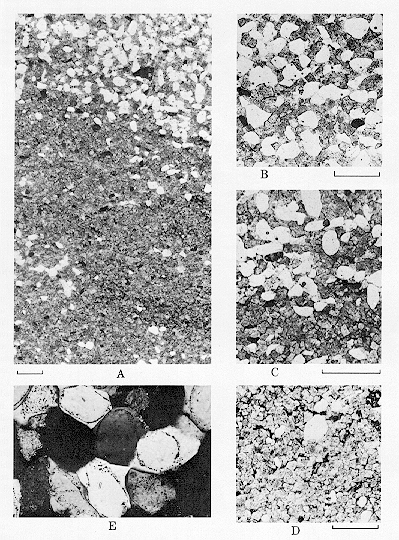
The Misener is primarily a quartz sand cemented with crystalline dolomite and grades into a crystalline dolomite with scattered quartz grains. These two end members are intimately associated, and the bedding commonly is defined by dolomite-rich layers alternating with quartz-rich layers (Fig. 4). Most quartz grains fall in the size range of 0.1-0.25 mm, with some ranging up to 0.50 mm; excluding the conglomeratic layers, few if any of the grains attain a diameter of 1.0 mm. Some conglomeratic beds are present, with the pebbles composed mainly of older rock fragments, mostly chert. Outlines of the quartz grains range from subrounded to angular; however, thin sections show that the angular fragments commonly represent crystal overgrowths on fairly well-rounded grains (Fig. 4E). The dolo ite is crystalline, and the individual crystals generally are somewhat smaller than the quartz grains (Fig. 4 A-D). Glauconite is moderately common in some beds and consists mainly of rounded to subangular grains about the same size as the quartz grains. Some Misener thin sections have many grains of a translucent, brown phosphate, much of which represents conodont material (Fig. 5), although some inarticulate brachiopods are known to be present. In places the matrix is chert, and some chert fragments are present. Bedding irregularities are developed, especially in those strata interbedded with shale, but no well-marked crossbedding has been observed in the cores. The Misener in the 1 Breckenridge and the 1 Holtzschue cores contains many beds and partings of dark shale; the sandstone par s of this core appear to be like those of the other Misener cores, and the shale looks like typical Woodford.
BIOSTRATIGRAPHY
Four of the standard conodont zones defined by Ziegler (1962, 1971) for the upper Middle Devonian and Upper Devonian are identified in four Misener cores from north-central Oklahoma (Fig. 6; Table 1). In ascending order, they are the Polygnathus varcus Zone, upper Middle Devonian
Fig. 3. Map showing locations of wells (dots) reporting Misener Sandstone; solid triangles indicate wells that cored Misener. No data are recorded for Misener in Marshall County.
End_Page 2326------------------------------
Click to view image in GIF format. Fig. 4. [Grey Scale] A-D. Photomicrographs, Misener Sandstone, Amerada 1 Breckenridge, C, NW 1/4, SW 1/4, Sec. 33, T25N, R6W, Garfield County, depth 6,254 ft; all from same thin section; bar 1/2 mm long. A. Enlarged view showing quartz sand (clear grains) with crystalline dolomite cement (above) and interbedded crystalline dolomite with scattered quartz grains (below). B. Detail showing quartz grains with dolomite cement. C. Detail of boundary between two rock types. D. Detail of crystalline dolomite with few quartz grains (clear). E. Photomicrograph, Misener Sandstone, Federal 1 Wolleson, NE 1/4, NE 1/4, Sec. 22, T21N, R2W, Noble County, depth 5,083 ft; enlarged approximately 150 time ; crossed nicols, showing rounded quartz grains with crystal overgrowths.
End_Page 2327------------------------------
(Federal 1 Wolleson); the lower P. asymmetricus Zone, lower Upper Devonian (Amerada 1 Richey; Gulf 1 Holtzschue, 6,446-6,447 and 6,443 ft); the middle P. asymmetricus Zone, lower Upper Devonian (Amerada 1 Breckenridge); and the upper Palmatodella triangularis Zone, upper Upper Devonian (Gulf 1 Holtzschue, 6,432-6,434 ft). No conodonts were recovered from the Gulf 1 Wright Heirs. The correlation of each zone is discussed in the following analysis of the cores.
Federal 1 Wolleson:
The oldest conodont fauna recovered from the Misener Sandstone is from the Wolleson core (Table 1). The fauna is referable to the Polygnathus varcus Zone (upper Middle Devonian), although there are European reports of P. varcus above the zone of its name. In North American sequences, however, P. varcus has not been demonstrated to range above the P. varcus Zone (Klapper et al., 1971, p. 298). For example, highest occurrences of the species are in the Solon Member (Middle Devonian) of the Cedar Valley Limestone of Iowa and directly below the Bellona coral bed in the higher part of the Tully Formation (Middle Devonian) of New York with Polygnathus beckmanni Bischoff and Ziegler. Following the taxonomic revision of Polygnathus varcus (Klapper et al., 1970, p. 651), it
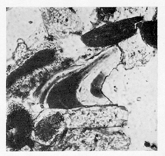
Click to view image in GIF format. Fig. 5. [Grey Scale] Photomicrograph, Misener Sandstone, Amerada 1 Breckenridge, C, NW 1/4, SE 1/4, Sec. 33, T25N, R6W, Garfield County, depth 6,265 ft; enlarged approximately 150 times; conodont section.
Fig. 6. Chart showing relative ages of conodont faunas from Misener Sandstone cores. Numbers refer to core footages.
End_Page 2328------------------------------
Table 1. Distribution and Number of Conodonts in Misener Sandstone
End_Page 2329------------------------------
may be that the reported (but unfigured) higher occurrences of the species above its zone are not conspecific.
The oldest fauna reported from the Sylamore Sandstone of northern Arkansas is assigned to the P. varcus Zone (Freeman and Schumacher, 1969, p. 2333, locs. 7, 10). This suggests that both Misener and Sylamore deposition began in the late Middle Devonian.
Amerada 1 Richey and lower fauna of Gulf 1 Holtzschue:
The next younger Misener fauna, at 6,443 ft in the Holtzschue core, is referred to the lower Upper Devonian, lower P. asymmetricus Zone (as emended by Ziegler, 1971, p. 267). The fauna at this level in the Holtzschue core is remarkably similar to those of the Squaw Bay Limestone (Michigan) and the Genundewa Limestone (New York), as all three contain Ancyrodella rotundiloba rotundiloba, Polygnathus dengleri, P. pennatus, and P. dubius (Klapper et al., 1971, p. 298). Slightly lower in the Holtzschue core, at 6,446-6,447 ft, the occurrence of Polygnathus norrisi is significant, because that species is limited in range to the Firebag Member of the Waterways Formation (Upper Devonian) in Alberta (Uyeno, 1967, Table 1). The Firebag is referred to the lower P. asymmetricus Zone by Uyeno (1967).
/P>
The fauna in the Richey core (6,241 ft, Table 1) also contains Polygnathus norrisi and correlates with the lower fauna of the Holtzschue core. The fauna at 6,264 ft in the Richey core is not diagnostic for a zonal assignment.
Freeman and Schumacher (1969, Fig. 2, loc. 7) reported the lower P. asymmetricus Zone within the Sylamore Sandstone of Arkansas. In the Sylamore, as in other North American sequences (Klapper et al., 1971, p. 298), the Schmidtognathus hermanni-Polygnathus cristatus Zone intervenes between the P. varcus Zone below and the lower P. asymmetricus Zone above. The S. hermanni-P. cristatus Zone, however, has not been recognized in the Misener, although this is probably the result of the meager data available.
Amerada 1 Breckenridge:
The fauna of the Breckenridge core (Table 1) is characterized by the presence of both Palmatodella punctata and Ancyrodella rotundiloba rotundiloba. The overlap in stratigraphic range of these taxa is indicative of the middle Polygnathus asymmetricus Zone (Ziegler, 1971, Chart 5), lower Upper Devonian. The oldest part of the Woodford Shale in the Arbuckle Mountain region of southern Oklahoma (Hass and Huddle, 1965, loc. D, 0-.06 ft above base of formation) contains both Ancyrodella rotundiloba and Palmatodella subrecta, the overlap of which also suggests the middle Polygnathus asymmetricus Zone. This indicates that the initiation of Woodford Shale deposition in southern Oklahoma was contemporaneous with part of Misener Sandstone deposition in north-central Oklahoma.
Upper Fauna of Gulf 1 Holtzschue:
The upper conodont fauna of the Holtzschue core is referred to the upper part of the Upper Devonian (Lower Famennian, Klapper et al., 1971, p. 302-303), to the upper Palmatodella triangularis Zone, on the basis of the overlap in range of Palmatodella quadrantinodosalobata and P. subrecta (Ziegler, 1962, Table 3). This zone is only 9 ft above the lower Polygnathus asymmetricus Zone at 6,443 ft in the Holtzschue core, but a change of greater magnitude is reported within a span of 10 ft in the Sylamore Sandstone (Freeman and Schumacher, 1969, Fig. 2, loc. 6), from the middle Polygnathus asymmetricus Zone to the Palmatodella rhomboidea Zone.
The upper Holtzschue fauna (6,432-6,434 ft) correlates in a general way with the Palmatodella glabra assemblage zone of Hass and Huddle (1965, p. D128, Fig. 2), which is developed within the Woodford Shale of southern Oklahoma. That zone, however, is a composite of several of the standard zones of Ziegler (1962), as shown by the analysis (Klapper et al., 1971, Fig. 4, col. 6) of faunas formerly assigned to the P. glabra assemblage zone from the Gassaway Member of the Chattanooga Shale of central Tennessee. The Holtzschue fauna may correlate with the Gassaway collections (157, 238, 43 from locality 100 of Hass, 1956) and several of the Woodford collections (e.g., those from loc. B of Hass and Huddle, 1965, p. D126), which contain Palmatodella subrecta and P. sp. A in association. The l st correlation assumes that Palmatodella sp. A listed by Hass and Huddle is the same as P. sp. A ( = P. quadrantinodosalobata) illustrated by Hass (1956, Pl. 3, Figs. 1-3, 13).
Summary:
The implication of these results is that a part of the Misener Sandstone (as indicated by the Breckenridge core and the upper conodont fauna of the Holtzschue core) was deposited contemporaneously with much of the Woodford Shale of the Arbuckle Mountain region in southern Oklahoma. Furthermore, the Misener is correlative with the older part of the Sylamore Sandstone in its type area in northern
End_Page 2330------------------------------
Arkansas. The base of the Misener appears to be diachronous, as is that of the Sylamore, but the limited information available on the Misener does not permit delineation of the geometry of the diachronism as in the example of the Sylamore (Freeman and Schumacher, 1969).
ENVIRONMENT OF DEPOSITION
Different interpretations have been offered as to the origin of the Misener Sandstone. Earlier authors inferred that it was a windblown deposit and most later investigators interpreted it as a marine sand. The Misener is primarily a quartz sand cemented with crystalline dolomite, grading into a crystalline dolomite with scattered quartz grains. Individual quartz grains are subrounded to rounded, commonly with crystal overgrowths. The bedding has some irregularities, although on the whole there is not much crossbedding, judging from available cores. The Misener is overlain by the Woodford Shale, and at least locally it is interbedded with dark shale of the Woodford type. The principal fossils are conodonts, although some linguloid brachiopods are present. On the basis of conodonts, its age ranges from late Middle to Late Devonian (Givetian-early Famennian), indicating that the base of the Misener is diachronous. Conodont age determinations also indicate that Misener Sandstone deposition in central Oklahoma was in part contemporaneous with Woodford Shale deposition in the Arbuckle Mountain region and thus, that the base of the Woodford is also time-transgressive. Regionally, the Misener truncates the underlying strata, in places overlying the Hunton, the Sylvan, the Viola, the Simpson, and older rocks. The general trend of its subcrop is northwest-southeast (the northeastern boundary is not well defined), and it extends westward onto the Hunton as far as, but only locally above, the 100-ft Hunton isopach (Fig. 2). The Misener Sandstone is erratic in its distribution and is absent in many parts of this belt; where present it is commonly less than 20 ft thick, and those areas where it exceeds 20 ft in thickness are aligned roughly in a northwest-southeast direction (Fig. 2).
The foregoing description suggests that the Misener represents a marine deposit laid down near an old shoreline. Certainly, substantial parts of the strata are marine, as they carry conodonts and linguloid brachiopods. Furthermore, the presence of dolomite would militate against a windblown origin. In those Misener beds which are composed of sand with a dolomite cement, the carbonate could represent a later, secondary deposit; however, the numerous beds of crystalline dolomite with only scattered quartz grains must be a primary carbonate and could hardly represent a dune sand.
According to our interpretation, the quartz sand in the Misener was derived in large part from the sands of the Ordovician Simpson Group. The Simpson Group contains several thick sandstones whose lithologic characteristics are similar to those of the Misener. This group is divided into five formations--in descending order--Bromide, Tulip Creek, McLish, Oil Creek, and Joins--the upper four of which contain substantial bodies of quartz sandstone (Decker and Merritt, 1931, p. 16; Record, 1948, Fig. 1); subsurface geologists commonly have called these the "Wilcox sands" (Jordan, 1957, p. 207). According to Ham (1945, p. 22), sandstone in the Oil Creek is composed largely of quartz grains in the fine-sand size (up to 0.24 mm in diameter) with no grains exceeding 0.5 mm; Fisher (1948, Fig. ) determined that the median size of all Simpson sands fall between 0.1 and 0.2 and that almost none exceeds 0.3 mm. Both investigators stated that the individual grains were well rounded and frosted (Ham, 1945, Pl. 7). Crystal overgrowths are uncommon in the Simpson sand grains, but this is presumably a secondary feature of the Misener, added after deposition. Whether the Misener grains are frosted would be difficult to determine because of the crystal overgrowths. Thus the Simpson sandstones represent a large, readily available source of quartz sand of the proper size and shape.
We infer that the Misener sea advanced in a general westerly direction over the exposed Simpson sands, where it picked up the weathered detritus, moving it westward over the higher Ordovician strata and onto the Hunton. At that time the Hunton strata on the west are assumed to have been topographically higher than the underlying strata, having been partly emergent as a northwest-southeast-trending shoreline. The Hunton margin appears to be dissected (Fig. 2), suggesting erosion by stream channels flowing in a general easterly direction. The sand-carbonate sediments laid down by the Misener sea as it advanced over this dissected part probably everywhere were deposited in shallow water. The thinner, more discontinuous parts possibly represent beach deposits filling topographic lows, and the thicker parts represent sand bars formed parallel
End_Page 2331------------------------------
with the old shoreline (Fig. 7). By Late Devonian time the deposition of black shale, which had begun earlier in the south in the Arbuckle region, spread over the entire area and buried all the older strata. The almost complete absence of any basal clastic facies in the Woodford of the Arbuckles probably is related to the absence of any substantial local source for such material (Amsden, 1960, p. 139; 1961, footnote, p. 42).
MISENER SANDSTONE, MARSHALL COUNTY, OKLAHOMA
The present study is concerned primarily with the Misener of north-central Oklahoma, and the following brief discussion of the Marshall County beds is included mainly for comparison. The Woodford Shale in parts of Marshall County is underlain by a sequence of dolomitic and cherty siltstones. These beds crop out in a small inlier on Turkey Creek (now beneath a lake) in northern Marshall County and extend in a southeasterly direction into the subsurface for a distance of 20 mi or more (Fig. 2). This siltstone unit has been variously designated the basal Woodford carbonate, brown dolomitic siltstone, Misener-Hunton, and Misener(?). It has been discussed and described by several authors including Amsden (1960, p. 259-262), Walters (1958, p. 14-15), Maxwell (1959, p. 121), and Amsden et al (1968, p. 162-163), all of whom concluded that it is almost certainly a basal facies of the Woodford. The siltstone occupies the stratigraphic position of the Misener Sandstone of north-central Oklahoma and the Sylamore Sandstone of eastern Oklahoma (Amsden, 1961, p. 61-68) and herein is considered to be approximately equivalent to those formations.
The best exposure of the Misener on Turkey Creek was Amsden's stratigraphic section Ma2, NE 1/4, NE 1/4, SE 1/4, Sec. 34, T4S, R4E (Amsden, 1960, p. 259-260; all the Turkey Creek exposures of the Misener are now covered by a lake). At section Ma2 the Misener overlies 5 ft of upper Lower Devonian limestone (beds A, B, C), which in turn lies on the Sylvan Shale, and is overlain unconformably by Cretaceous strata; however, exposure of the Woodford Shale in the immediate vicinity makes it appear reasonably certain that the latter lies on the Misener where it has not been removed by post-Woodford, pre-Cretaceous erosion (Amsden, 1960, p. 156). Section Ma2 (beds D, E, F) includes 50 ft of Misener, with an unknown amount of beds having been removed by post-Misener, pre-Cretaceous erosion.
The principal source of information on the subsurface distribution of the Misener in Marshall County is Walters (1958, Pl. 1), who showed an elongate belt of Misener extending in a southeasterly direction to near the Texas border. According to Walters, the Misener in this belt has a maximum thickness of about 100 ft.The strata formerly exposed on Turkey Creek consist of a sequence of dolomitic siltstones with a substantial amount of chert. The typical siltstone is composed of angular quartz grains accompanied by considerable mica and glauconite set in a matrix of crystalline dolomite (Fig. 8). Most of the quartz grains are less than 0.1 mm in diameter and fall in the silt-size range (Amsden, 1960, p. 155, incorrectly gave the size range as 0.4-0.6 mm); they are angular and do not appear to have developed any crystal overgrowths. The acid-soluble part of this rock ranges from 30 to 40 percent, with MgCO3 making up 12-13 percent of the soluble part (Amsden, 1960, p. 295). This rock type grades into beds in which the matrix is partly to almost completely replaced by chert; however, even t e cherty parts retain much crystalline dolomite and have up to 18 percent MgCO3. Beds of vitreous chert also are present. Some of the siltstone beds show minor crossbedding. No fossils have been observed in the surface exposures or in the thin sections. The Misener
Fig. 7. Diagram showing inferred position of sea level at close of Misener deposition. Thickness of Misener Sandstone exaggerated.
End_Page 2332------------------------------
Sandstone lies on the Turkey Creek limestone unit of late Early Devonian age (Amsden et al., 1968, p. 163-164).
The siltstone beds are correlated with strata cored in the Texas 1 Gipson, about 10 mi southeast of Turkey Creek in the NE 1/4, NE 1/4, NW 1/4, Sec. 11, T6S, R6E (cored interval, 4,020-4,121 ft; University of Oklahoma Core Library). Walters (1958, p. 19) assigned these strata to the Misener(?) and stated they contained 87 percent carbonate; however, this carbonate content appears much too high, as 10 X-ray diffractograms and 3 thin sections studied by T. L. Rowland, Oklahoma Geological Survey, show the rock to be a dolomitic, glauconitic, and micaceous siltstone with much detrital quartz, mostly in the silt-size range. The upper part of the core is interbedded with typical Woodford dark shale, and Maxwell (1959, p. 121) noted the presence of Woodford-type spores, the lowest from a dep h of 4,115 ft, just 10 ft above the Sylvan Shale. No limestone corresponding to the Lower Devonian Turkey Creek limestone unit has been found in the 1 Gipson, or in any of the wells penetrating the Misener in Marshall County, and in the subsurface the Misener apparently lies on the Ordovician Sylvan Shale or Viola Limestone (Walters, 1958, Pl. 1). The Marshall County Misener and the Misener of north-central Oklahoma occupy the same stratigraphic position. Both appear to represent an early phase of Woodford deposition and are considered herein to be at least in part contemporaneous. However, lithologically, the Marshall County strata differ from those of north-central Oklahoma in several respects. The quartz detritus is considerably finer, much more angular, and mica, which has not been o served in the north-central strata, is a common constituent. Some chert is present in the northern areas, but it is not nearly so abundant as in the Turkey Creek area. These differences are in all probability the result of differences in the source of the clastics, possibly combined with some minor differences in the environment of deposition. The detritus in the Misener of north-central Oklahoma is believed to have been derived from an older sandstone and thus to have been subject to considerable transportation and long continued abrasion, whereas the sand in the Misener of Marshall County appears to have been subjected to much less abrasion, suggesting a closer primary source, possibly the nearby Ouachita region (Fig. 2).
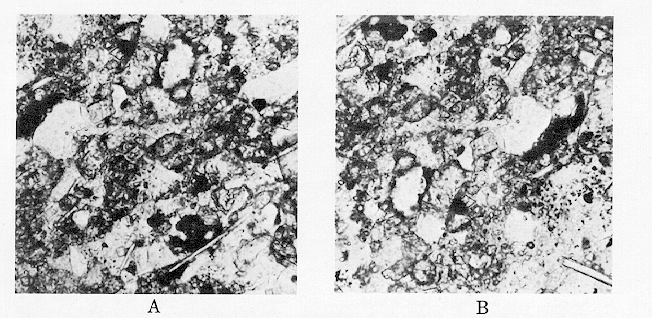
Click to view image in GIF format. Fig. 8. [Grey Scale] Photomicrographs, Misener Sandstone, lower 30 ft, Turkey Creek, NE 1/4, NE 1/4, SE 1/4, Sec. 34, T4S, R4E, Marshall County (stratigraphic section Ma2-D, Amsden, 1960, p. 259-260); approximately 150 times. Thin sections show angular quartz grains, dolomite crystals, and mica.
References:
Amsden, T. W., 1960, Stratigraphy and paleontology of the Hunton Group in the Arbuckle Mountain region. Pt. 6, Hunton stratigraphy: Oklahoma Geol. Survey Bull. 84, 311 p.
End_Page 2333------------------------------
Amsden, T. W., 1961, Stratigraphy of the Frisco and Sallisaw Formations (Devonian) of Oklahoma: Oklahoma Geol. Survey Bull. 90, 121 p.
Amsden, T. W., G. Klapper, and A. R. Ormiston, 1968, Lower Devonian limestone of post-Hunton age, Turkey Creek inlier, Marshall County, south-central Oklahoma: Am. Assoc. Petroleum Geologists, Bull., v. 52, no. 1 p. 162-166.
Amsden, T. W., and T. L. Rowland, 1965, Silurian stratigraphy of northeastern Oklahoma: Oklahoma Geol. Survey Bull. 105, 174 p.
Borden, J. L., and R. A. Brant, 1941, East Tuskegee pool, Creek County, Oklahoma, in Stratigraphic type oil fields: Am. Assoc. Petroleum Geologists, p. 436-455.
Decker, C. E., and C. A. Merritt, 1931, The stratigraphy and physical characteristics of the Simpson Group: Oklahoma Geol. Survey Bull. 55, 112 p.
Fisher, S. P., 1948, A mineral and sedimentation study of the Simpson group sandstones, Arbuckle Mountains area, Oklahoma: M.S. thesis, Oklahoma Univ., 57 p.
Freeman, T., and D. Schumacher, 1969, Qualitative pre-Sylamore (Devonian-Mississippian) physiography delineated by onlapping conodont zones, northern Arkansas: Geol. Soc. America Bull., v. 80, no. 11, p. 2327-2334.
Ham, W. E., 1945, Geology and glass sand resources, central Arbuckle Mountains, Oklahoma: Oklahoma Geol. Survey Bull. 65, 103 p.
Hass, W. H., 1956, Age and correlation of the Chattanooga Shale and the Maury Formation: U.S. Geol. Survey Prof. Paper 286, 47 p.
Hass, W. H., and J. W. Huddle, 1965, Late Devonian and Early Mississippian age of the Woodford Shale in Oklahoma, as determined from conodonts, in Geological Survey research 1965: U.S. Geol. Survey Prof. Paper 525-D, p. D125-D132.
Jordan, L., 1957, Subsurface stratigraphic names of Oklahoma: Oklahoma Geol. Survey Guidebook 6, 220 p.
Klapper, G., and G. M. Philip, 1971, Devonian conodont apparatuses and their vicarious skeletal elements: Lethaia, v. 4, p. 429-452.
Klapper, G., and G. M. Philip, and J. H. Jackson, 1970, Revision of the Polygnathus varcus group (Conodonta, Middle Devonian): Neues Jahrb. Geologie u. Palaontologie Monatsh. Jg. 1970, no. 11, p. 650-667.
Klapper, G., et al., 1971, North American Devonian conodont biostratigraphy, in Symposium on conodont biostratigraphy: Geol. Soc. America Mem. 127, p. 285-316.
Maxwell, R. W., 1959, Post-Hunton pre-Woodford unconformity in southern Oklahoma, in Petroleum geology of southern Oklahoma, v. 2: Am. Assoc. Petroleum Geologists, p. 101-126.
Rau, H. L., and K. A. Ackley, 1939, Geology and development of Keokuk pool, Seminole and Pottawatomie Counties, Oklahoma: Am. Assoc. Petroleum Geologists Bull., v. 23, no. 1, p. 220-245.
Record, W. R., Jr., 1948, A subsurface study of the Simpson Group of rocks of Garvin County and adjacent area, central Oklahoma: M. S. thesis, Oklahoma Univ., 71 p.
Uyeno, T. T., 1967, Conodont zonation, Waterways Formation (Upper Devonian), northeastern and central Alberta: Canada Geol. Survey Paper 67-30, 21 p.
Walters, D. L., 1958, The pre-Woodford subcrop and its relationship to an overlying detrital lithofacies in northeast Marshall and southwest Johnston Counties, Oklahoma: M.S. thesis, Oklahoma Univ., 37 p.
White, L. H., 1926, Subsurface distribution and correlation of the pre-Chattanooga ("Wilcox" sand) series of northeastern Oklahoma: Oklahoma Geol. Survey Bull. 40-B, 23 p.
White, L. H., and F. C. Greene, 1924, Four horizons below Mississippi lime: Oil and Gas Jour., v. 23, no. 15, p. 42, 68.
Wilmarth, M. G., 1938, Lexicon of geologic names of the United States (including Alaska): U.S. Geol. Survey Bull. 896, 2396 p.
Ziegler, W., 1962, Taxionomie und Phylogenie Oberdevonischer Conodonten und ihre stratigraphische Bedeutung: Hess. Landesamt Bodenforschung Abh., no. 38, 166 p.
Ziegler, W., 1971, Conodont stratigraphy of the European Devonian, in Symposium on conodont biostratigraphy: Geol. Soc. America Mem. 127, p. 227-284.
End_of_Article - Last_Page 2334------------
Acknowledgments:
(2) Oklahoma Geological Survey.
(3) University of Iowa.
Pay-Per-View Purchase Options
The article is available through a document delivery service. Explain these Purchase Options.
| Watermarked PDF Document: $14 | |
| Open PDF Document: $24 |
AAPG Member?
Please login with your Member username and password.
Members of AAPG receive access to the full AAPG Bulletin Archives as part of their membership. For more information, contact the AAPG Membership Department at [email protected].