The AAPG/Datapages Combined Publications Database
AAPG Bulletin
Figure
AAPG Bulletin; Year: 2020; Issue: May DOI: 10.1306/10031919011
Return to Full Text
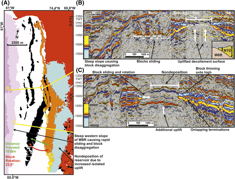
Figure 13. Areas of reservoir nondeposition. (A) A comparison of modern-day (black) and reconstructed (colored) reservoir block locations, shown on top of a two-way time (TWT)–structure map of the decollement surface. Areas of reservoir nondeposition are highlighted in blue. The map location and decollement surface legend are shown in Figure 10. (B) A seismic section showing the location of an uplifted platform on the decollement surface on which reservoir deposition did not occur. The schematic insert depicts the thinning of the reservoir against this uplifted high. The line location is shown in Figure 10. (C) A seismic section showing nondeposition and subsequent sliding of a reservoir block to suggest block rotation. The line location is shown in Figure 10. MBR = Melville Bay ridge; MTD = mass transport deposit.
Figure 13. Areas of reservoir nondeposition. (A) A comparison of modern-day (black) and reconstructed (colored) reservoir block locations, shown on top of a two-way time (TWT)–structure map of the decollement surface. Areas of reservoir nondeposition are highlighted in blue. The map location and decollement surface legend are shown in Figure 10. (B) A seismic section showing the location of an uplifted platform on the decollement surface on which reservoir deposition did not occur. The schematic insert depicts the thinning of the reservoir against this uplifted high. The line location is shown in Figure 10. (C) A seismic section showing nondeposition and subsequent sliding of a reservoir block to suggest block rotation. The line location is shown in Figure 10. MBR = Melville Bay ridge; MTD = mass transport deposit.