About This Item
- Full text of this item is not available.
- Abstract PDFAbstract PDF(no subscription required)
Share This Item
The AAPG/Datapages Combined Publications Database
GCAGS Transactions
Abstract
Abstract: Short-Term Performance of Segmented Breakwaters along Raccoon Island, Louisiana
Abstract
The Isles Dernieres barrier island chain (Fig. 1) is experiencing some of the highest rates of erosion of any coastal region in the world. As part of a comprehensive barrier island restoration plan along the Isles Dernieres, the Raccoon Island Breakwaters Demonstration (TE-29) project consisted of eight segmented breakwaters constructed in June and July 1997, to reduce the rate of shoreline retreat and protect the bird habitat of the Louisiana State Bird, the Brown Pelican. In order to monitor the short-term performance of these breakwaters, topographic/bathymetric surveys have been conducted at biannual intervals along the island from November 2000 to July 2005.
Results have shown that, in all surveys, a shoal located off the eastern portion of Raccoon Island is clearly apparent and undergoes seasonal variability showing erosional trends in the winter (November-May) and deposition in the summer (May-November). Data indicate that the shoal likely serves as an important sediment source for material deposited in the vicinity of the breakwaters.
Erosion has occurred behind the eastern three breakwaters as well as on the shore-face. The likelihood of deposition behind these structures was largely inhibited because of the occurrence of a tidal channel which actively scoured during winter months. Deposition occurred east of breakwater 0 along the west flank of the pass between Raccoon and Whiskey islands.
West of breakwater 3, the trend was depositional behind the structures, while west of the breakwaters the shoreface and beach was predominantly erosional, with a hot spot immediately west of breakwater 7. This is in part due to an interruption by the breakwaters of east to west longshore transport.
The entire volume of sediment accumulation or erosion landward and seaward of breakwaters was calculated down to the 15-ft isobath for the survey period (Table 1; Fig. 2). Sediment volume seaward of breakwaters had a decreasing trend from November 2000 to July 2003, which is in accordance with the shoal as the sediment source. Sediments in area landward of breakwaters was not as significantly impacted as those seaward of breakwaters, with only about 0.2% sediment volume loss. However, sediments landward of breakwaters were significantly impacted by Hurricane Ivan, during which about 8.4% sediments were eroded (Table 1; Fig. 2).
Sand appears to have been preferentially deposited along breakwaters 3--7 due to the presence of the shoal and the orientation of the structures. A channel exists between breakwaters 0 and 1 and considerably more scour is evident along the eastern flank of the structures than to the west. Much of the resuspension of sediment along the eastern three breakwaters is accomplished during the passage of cold fronts, with one such example occurring during late September and the first part of October, during which maximum current velocities of 1.8 ft/sec (55 cm/sec) to the west were recorded on the flanks of the channel at breakwaters 0 and 1. This explains why sediment did not accumulate behind breakwaters 0 and 1 in the same manner it accumulated behind the remainder of the breakwaters to the west.
By July 2005, a downdrift (west) erosional shadow was becoming evident along Raccoon Island that would appear to be attributable to construction of the breakwaters. The shadow extends from transect 18, immediately west of breakwater 7, to transect 22, a distance of 1,800 ft. Based on the 2000-2005 data, the shoreline retreated at rates ranging between 48.65 to 75.36 ft/yr along this 1,800-ft-long site. Historically (1887-2002), the same area eroded at a rate of 27.4 ft/yr, and while the short-term rates are considerably higher than those derived from the longer-term data set, and consequently some of the difference can thus be explained; the morphological evidence of a downdrift landward offset is convincing.
The data presented in this paper will provide considerable information regarding design criteria for future restoration efforts along this stretch of coast in addition to the response of beach and nearshore environments to breakwater construction given similar physical and hydrodynamic conditions at other sites. In particular, data presented here have provided new insight into the linkages between sediment flux in the littoral zone, proximal sediment sources and anticipated responses along adjacent coasts where structures may be built. The data indicate that the functional design of detached breakwaters should include an assessment of the availability of sediment immediately offshore. Given that the structures apparently disrupt the cross-shore wave propagation path, the possibility of cross-shore sand trapping should be addressed in the design of future projects, even for the largely non-permeable segmented structures. Data presented here will also be beneficial in potentially leading to modification of the engineering design of the current breakwater configuration. This includes increasing the potential for sand retention behind the eastern two breakwaters (0 and 1) and a reduction in shoreline retreat by the construction of an additional structure perpendicular to breakwater 0 and attachment to the beach at Raccoon Island. Engineering analysis and design will be required to test further the feasibility of this undertaking.
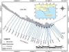 Figure 1. Study area showing the location of Raccoon Island, the breakwaters along the eastern part of the island, as well as topographic/bathymetric survey transects. Shoreline was based on an aerial photograph taken on February 6, 2002 by the U.S. Geological Survey.
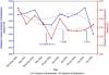 Figure 2. Sediment volumes in the areas landward and seaward of the breakwaters.
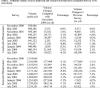 Table 1. Sediment volumes of areas landward and seaward of breakwaters calculated down to -15 ft (NGVD 29).
Acknowledgments and Associated Footnotes
1 Coastal Studies Institute, Louisiana State University, Baton Rouge, LA 70803
2 Coastal Studies Institute and Department of Oceanography and Coastal Sciences, Louisiana State University, Baton Rouge, LA 70803
Copyright © 2007 by The Gulf Coast Association of Geological Societies