About This Item
- Full text of this item is not available.
- Abstract PDFAbstract PDF(no subscription required)
Share This Item
The AAPG/Datapages Combined Publications Database
Montana Geological Society
Abstract
MTGS-AAPG
Montana Geological Society: Twenty-fourth Annual Conference: 1978 Williston Basin Symposium: The Economic Geology of Williston
Basin
September 24-27,
ABSTRACT: Paleozoic Correlations and Regional Porosity Patterns, Central and Eastern Montana
ABSTRACT
Predictable Paleozoic regional carbonate-porosity patterns are mappable in the subsurface of the Williston Basin through application of a marker-bed correlation system. Reasonably well-defined marker-beds, identified primarily on gamma ray or sonic logs, are present in all of the Paleozoic section and provide an efficient stratigraphic framework for mapping regional and local porosity facies useful in exploration for water resources and petroleum.
Major carbonate-porosity patterns are associated almost exclusively with widespread dolomitization. High-permeability carbonate porosity is primarily found in tabular-shaped, medium to coarsely crystalline dolomite units, ranging from a few feet up to 100 feet or more in thickness. In the Madison Limestone (or Madison Group), the low-porosity limestone facies is mainly composed of oolitic limestone, or skeletal organic material, commonly crinoids, or argillaceous deeper water limestones. Concentrations of organic or oolitic limestone buildups, as well as dolomitization patterns, in the western Williston Basin, appearto be influenced by the regional paleostructural framework active at the time of deposition. Particularly important paleostructural elements are the Baker-Glendive Anticline, Miles City Arch, Central Montana Uplift, North-Central Montana Platform (southern part of the Alberta Shelf), and the Central Montana (Big Snowy) Trough. Local distribution of carbonate facies and porosity patterns may also be related to more detailed patterns of local paleostructural growth during time of deposition.
 |
Figure 1: |
Index map of central and eastern Montana, showing main structural features, outcrop of Madison Limestone (Group), well and surface control, drilling depth to top of Madison Limestone (Group), and location of correlation cross sections (Figures 2,3 and 4) in pocket in back of guidebook. |
 |
Figure 2: |
Southwest-northeast cross-section A-B-C, north end of Big Horn Mountains to west side of Williston Basin. Datum: top of Jurassic Firemoon Limestone Member of Piper Formation. |
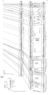 |
Figure 3: |
Southwest-northeast cross-section C-D (extension of cross-section A-B-C, Figure 2), west side of Williston Basin. Datum: top of Jurassic Firemoon Limestone Member of Piper Formation. |
 |
Figure 4: |
North-south cross-section B-E (extension of A-B part of cross-section A-B-C, Figure 2,) northeast of Billings to Canadian border. Datum: top of Jurassic Firemoon Limestone Member of Piper Formation. |