About This Item
- Full text of this item is not available.
- Abstract PDFAbstract PDF(no subscription required)
Share This Item
The AAPG/Datapages Combined Publications Database
Montana Geological Society
Abstract
MTGS-AAPG
Montana Geological Society: Fiftieth Anniversary Symposium: Montana/Alberta Thrust Belt and Adjacent Foreland: Volume II
---,
EXPANDED ABSTRACT: Interplay of Structure, Facies, and Unconformities on Sites of Biogenic Gas Accumulation in Upper Cretaceous Belle Fourche and Greenhorn Formations— Alberta, Saskatchewan, and Montana
ABSTRACT
Biogenic gas is produced from shallow, low-permeability sandstones in the Upper Cretaceous Belle Fourche and Greenhorn formations in southern Alberta, southwestern Saskatchewan, and north-central Montana (Figure 1). Reservoirs are most productive where they are associated with large- or small-scale structures, but lack the downdip water contact normally associated with conventional gas accumulations. The lack of a conventional water drive, the occurrence of the gas in low permeability rocks, and its seemingly pervasive (although not always economic) presence throughout the host formations suggest that these gas accumulations fit the criteria for continuous gas accumulations set forth by the U.S. Geological Survey (Schmoker, 1996).
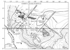 |
Figure 1: |
Location of shallow biogenic gas production from the Belle Fourche and Greenhorn formations, Alberta, Saskatchewan, and Montana. Production in Alberta is from upper Belle Fourche sands (cross), in Saskatchewan from "lower Phillips" sands (dark gray) and upper Belle Fourche sands (cross), and on Bowdoin Dome, Montana from lower Phillips and upper Phillips/Mosby sands and Greenhorn (light gray). Structure contours on top of the Second White Specks. Lineaments from (Anna, 1986) and (Kent and Christopher, 1994). |
Regional correlations of the Belle Fourche and Greenhorn formations are shown in Figure 2. Using these correlations, most of the shallow biogenic gas production is assigned to the Belle Fourche Formation in Canada and Montana, although in Canada, the producing sands are commonly called the Second White Specks sandstones by industry. In Alberta, the most northerly production is in distal sands of the upper Belle Fourche depositional system that interfinger with coccolithic shale. This coccolithic shale occurs below the bioclastic limestone that defines the base of the Second White Specks Formation (Bloch and others, 1993). The base of the limestone represents an unconformity between the Belle Fourche and the Second White Specks Formation in Alberta, Saskatchewan, and northern Montana.
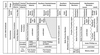 |
Figure 2: |
Stratigraphic correlation of the Belle Fourche and Greenhorn formations in southeastern Alberta, southwestern Saskatchewan, and north-central Montana. Gas-bearing sandstones (gray) are called Second White Specks sandstones by industry. Revised from (Bloch and others, 1993). |
The Belle Fourche was deposited as a progradational sequence during an overall sea level rise. As such, older units should pinch out and condense basinward (north) and should be overlain by successively younger strata. During maximum transgression (Greenhorn sea), basinal rocks (Bridge Creek-Keld-Second White Specks) would overlie these younger strata. Because the upper Belle Fourche was deposited below wave base, it would not be truncated by the transgressing sea. However the observed pattern of facies distribution in the Belle Fourche in southeastern Alberta, southern Saskatchewan, and northern Montana does not show progressive downlapping of younger Belle Fourche strata on older facies of the Belle Fourche. Instead, the upper Belle Fourche appears to be progressively truncated to the north under the Second White Specks, such that older facies of the Belle Fourche are brought closer to the basal Second White Specks unconformity. This loss of the upper Belle Fourche below the Second White Specks Formation cannot be explained solely through facies intertonguing between the two formations or condensing of the upper Belle Fourche to the north. From south-to-north in central Montana, the lower Belle Fourche gradually pinches out between the top of the Fish Scales Formation and the base of the lower Phillips equivalent sands (Condon, 2000). This gradual pinchout is also observed in Canada, where subtle syndepositional movement on local structures causes thickening and thinning of this interval and results in local unconformities within the basal Belle Fourche. Likewise, the upper part of the Belle Fourche, including the reservoir sands assigned to the Mosby Sandstone, is gradually truncated below the Second White Specks Formation. Loss of upper Belle Fourche facies occurs along an arcuate zone starting around T40N, R5W4 in Alberta and trends just west of the South Saskatchewan River and then southeasterly through the Big Stick and South Crane Lake pools (T12-15N, R25-30W3) and the Wymark pool (T12-14N, R12-14W3). From T40N, R5W4, the zone trends to the northwest. This loss of the upper Belle Fourche is observed in the South Crane Lake, Big Stick, and Wymark gas pools, where speckled shale rests on noncalcareous shale that overlies glauconitic sandstone (Gilboy, 1988) (lower Phillips equivalents). In northern Montana, loss of upper Belle Fourche facies can be seen along a transect in the subsurface from just south of the crest of the Bowdoin Dome in Montana, north to the Wymark pool in Saskatchewan. In Alberta, west of the South Saskatchewan River, loss of upper Belle Fourche facies is less pronounced; eventually these facies too are cut out or condense below the Second White Specks to the north.
The cause of the loss of upper Belle Fourche lithologies through southwestern and south-central Saskatchewan and northern Montana is still under investigation. Facies analyses, detailed isopach maps, and foraminiferal and nanno-fossil studies are being integrated to understand the relative roles of local versus regional tectonics, loss of facies through normal deposition, and the presence of condensed sections as explanations to the observed stratigraphy. 40Ar/Ar39 dating of sanidine in key bentonite marker beds will help to define genetic packages of rocks and to clarify the role of syndepositional tectonics of local and regional scale and presence of condensed sections. Two northeast-trending linear features, the North Battleford Arch and the Shaunavon Lineament (Kent and Christopher, 1994) bracket the area in Saskatchewan where the Belle Fourche is truncated below the base of the Second White Specks. A possible explanation for the observed stratigraphic succession is movement on the structural block between the two lineaments. If this structural block is segmented, it is possible that differential movement on the block as a whole or on segments coupled with differential tilting could bring the upper part of the Belle Fourche in the storm wave base zone resulting in submarine erosion of the sediment during transgression of the Greenhorn sea. A possible mechanism for driving the uplift could be thrust loading and subsequent relaxation in the disturbed belt west of a line between Cut Bank and Great Falls, Montana, just prior to or coincident with maximum transgression of the Greenhorn sea. The eastern limit of the disturbed belt in this area (Dyman and others, 1994; Figure 1) lies directly southwest of the zone defined by the two lineaments in Saskatchewan.
In southern Alberta and southwestern Saskatchewan, isolated production from sandstone equivalent to the Mosby appears to be related to small anticlinal structures (Gilboy, 1988). In the principal gas producing area in southern Alberta, production is mostly from upper sands in the Belle Fourche. The sands occur as part of thin 4th-order parasequence sandstone-shale couplets; the interbedded lithologies provide low-permeability traps. Northward facies changes in the sandstone-shale couplets as well as their successive truncation below the unconformity at the base of the Second White Specks, provide downdip traps to migrating gas. In the main gas producing areas in southwestern Saskatchewan, all production in the South Crane Lake, Big Stick, and Wymark gas pools is from the glauconitic "lower Phillips" sand, with minor production from the underlying Terebellina-burrowed sand. The new Wymark gas pool represents the first major step-out from areas of known production. Although production is on a northeast-trending structure that corresponds to the northeast side of the Moose Jaw syncline, its setting in a regional picture is related to the position of productive sands below the Second White Specks unconformity. On Bowdoin Dome, gas production, exclusive of the Bowdoin and Martin sands, is from the upper and lower Phillips or Greenhorn. Applying the criteria of continuous gas accumulation, the whole area in southern Alberta and Saskatchewan and north-central Montana should be gas saturated. However, there are large areas, which have been marginally tested, where no large gas accumulation has been defined. These areas are still relatively underexplored, as many of the "dry" tests in the area did not always test the glauconitic sand or other Belle Fourche reservoirs. The large areas of gas production in Alberta, Saskatchewan, and on the Bowdoin Dome reflect step-out drilling from initial known producing wells and the sizes of the producing areas have grown through normal field growth engineering practices.
Controls on the sites of the major gas accumulations found to date are due to the interplay of 1) northward facies changes including the presence of condensed sections in the depositional systems of the Belle Fourche and Second White Specks, 2) unconformities within and between the Belle Fourche and Second White Specks, resulting from local and regional tectonics, and 3) the down-structure position of these relationships on the Sweetgrass Arch, Bowdoin Dome, and along the northeast side of the Moose Jaw Syncline (Figure 1). The northern boundary of the shallow biogenic gas accumulations appears to be coincident with both seaward changes in depositional facies and truncation of these facies in the Belle Fourche below the unconformity marking the base of the Second White Specks. These changes converge along the distal ends of the arch where the structure contours tend to flatten. During the Laramide Orogeny, when the Sweetgrass Arch was forming, there was sufficient change in gradient and pressure decrease due to subsequent erosion, to permit gas in solution or as a free phase to migrate. The gas was trapped in the downdip parts of the structure where pinch out or truncation of facies occur. As the volume of gas exsolved and filled available pore space, growth of the gas accumulation occurred in the up-structure direction of favorable facies. Neither the extent of this gas accumulation up-structure nor the duration of gas migration and exsolution is presently known.
REFERENCES CITED
Anna, L.O., 1986, Structural influences on Cretaceous sedimentation, northern Great Plains, in Peterson, J.A., ed., Paleotectonics and sedimentation in the Rocky Mountain Region, United States: American Association of Petroleum Geologists Memoir 41, p. 173-191.
Bloch, J., C. Schroder-Adams, D.A. Leckie, D.J. Mclntyre, J. Craig, and M. Staniland, 1993, Revised stratigraphy of the Lower Colorado Group (Albian to Turanian), Western Canada: Bulletin of Canadian Petroleum Geology, v. 41, n. 3, p. 325-348.
Condon, S.M., 2000, Stratigraphic framework of Lower and Upper Cretaceous rocks in central and eastern Montana: U.S. Geological Survey Digital Data Series DDS-57 (CD-ROM).
Dyman, T.S., E.A. Merewether, CM. Molenaar, W.A. Cobban, J.D. Obradovich, R.J. Weimer, and W.A Bryant, 1994, Stratigraphic transects for Cretaceous rocks, Rocky Mountains and Great Plains regions, in Caputo, M.V., J.A Peterson, and K.J. Franczyk, eds., Mesozoic Systems of the Rocky Mountain Region, USA, p. 365-392.
Gilboy, C.F.,1988, Geology and natural gas production of the Upper Cretaceous Second White-Speckled Shale, southwestern Saskatchewan, in Summary of Investigations 1988: Saskatchewan Energy and Mines, Miscellaneous Report 88-4, p. 183-195.
Kent, D.M, and J.E Christopher, 1994, Geological history of the Williston Basin and Sweetgrass Arch, in Mossop, G., and I. Shetsen, comp., Geological Atlas of the Western Canada Sedimentary Basin: Chapter 27, p. 421-424.
Schmoker, J.W., 1996, Methodology for assessing continuous-type (unconventional) hydrocarbon accumulations, in Gautier, D.L., G.L. Dolton, K.I. Takahashi, and K.L. Varnes, eds., 1995 National assessment of United States oil and gas resources-results, methodology, and supporting data: U.S. Geological Survey, Digital Data Series DDS-30. Release 2.