About This Item
- Full TextFull Text(subscription required)
- Pay-Per-View PurchasePay-Per-View
Purchase Options Explain
Share This Item
The AAPG/Datapages Combined Publications Database
Saskatchewan Geological Society
Abstract
D. The Exploration Frontier: Ideas Worth Exploring,
The Provenance of Prairie Tills and its Importance in Mineral Exploration
Robert G. Garrett
Mineral Resources Division, Geological Survey of Canada, 601 Booth Street, Ottawa, ON K1A 0E8
L. Harvey Thorleifson
Terrain Sciences Division, Geological Survey of Canada, 601 Booth Street, Ottawa, ON K1A OE8
A surface and subsurface indicator mineral and soil geochemical survey designed to examine diamond and metallic mineral potential, glacial sediment transport history, and both exploration and environmental geochemistry, was undertaken in southern Saskatchewan in 1992. Surface sampling sites were randomly selected prior to field work with two sites in 40 km by 40 km cells designated for sampling of till and soil, and additional sites designed to define local variability of soils. Till was collected from 1 to 2 m depth from surface exposures, mainly road cuts, whereas soil samples from the A and C horizons were obtained from sites randomly distributed on all parent materials. In addition to surface sampling, the entire Quaternary sediment sequence was cored at a site overlying kimberlite near Smeaton. Several areas of favourable kimberlite indicator mineral suites were defined. In order to better constrain the source of these indicator minerals, lithological, mineralogical, and geochemical analyses of till were used to provide evidence of the bedrock source of the sediment. These analyses indicate that surface till in southern Saskatchewan may be divided into three broad domains, a western area southwest of the Missouri Coteau, an eastern domain east of the Coteau and south of the North Saskatchewan and Saskatchewan rivers, and a northern domain north of the Saskatchewan River and the Coteau. In the eastern domain, high-levels of carbonate and several elements attributed to black shales of the Manitoba Escarpment indicate that most sediment transport in the area was dominated by westward ice flow, not the late glacial southeastward flow that sculpted the landscape. In contrast, this late flow seems to have had a pervasive influence in the northern domain, where surface till contains abundant Shield debris derived from the north. Drilling within the northern domain indicated that this Shield-derived till is 35 m thick at the tested site, and that the carbonate-rich till characteristic of the eastern domain is present in the immediately underlying 34 m. The remainder of the 100 m drilled sequence is closer in composition to underlying bedrock. In the western domain, till is intermediate in composition between the other two areas, perhaps indicating a complex mixture of materials derived from both distant sources as well as local shales and sandstones. In addition, in the southwest, the tills contain abundant material reworked from Tertiary gravels. Mineral exploration programs should be guided by insights such as these which indicate the transport history of the glacial sediments being sampled.
The discovery of diamond-bearing kimberlites in north-central Saskatchewan in 1988 (Lehnert-Thiel et al., 1992) led to a surge of exploration activity that included sampling glacial, glaciofluvial, and fluvial sediments for indicator minerals. At the time, however, few data were available in the public domain regarding the frequency and chemistry of kimberlitic indicator minerals in the region. Without this background information, it was difficult to assess the significance of more localized exploration data sets. Funding under the Canada-Saskatchewan Partnership Agreement on Mineral Development, initiated in 1990, therefore, was directed to this topic. Two traverses across the region, completed in 1991 (Garrett and Thorleifson, 1993), revealed mappable patterns in heavy mineral abundances, pebble lithology, and geochemistry. The survey subsequently was extended into Alberta under the Canada-Alberta Agreement on Mineral Development, and into Manitoba in cooperation with the Manitoba Geological Services Branch. Thus, in 1992, a prairie-wide ultra-low density reconnaissance survey was completed, consisting of 816 till samples collected at a density of approximately one site per 800 km² (Garrett and Thorleifson, 1996). The till samples were collected from approximately 1 to 2 m below surface, beneath the influence of major soil- forming processes, but in the oxidized zone. The data arising from the survey have been released in a series of open files (Thorleifson and Garrett, 1993; Thorleifson et al., 1994). The field and laboratory procedures and key results for the Saskatchewan part of the survey have been presented and discussed by Garrett and Thorleifson (1995), and similarly for Alberta by Thorleifson and Garrett (1997).
For the successful follow-up of indicator mineral data, knowledge of the provenance of the sampled sediments and their depositional history is essential. The survey, therefore, also was designed to acquire information on the transport history of the sediments, as indicated by 8 to 16 mm pebble lithology, 63 to 250 μm heavy mineral (>3.2 S.G.) abundance and bulk chemistry, and <63 μm till geochemistry, or ratios and other such simple derivatives. In some cases, inferred sediment transport trends differ from the orientation of glacial geomorphological features left by the most recent glacial event.
In addition, in 1992, a multi-disciplinary Geological Survey of Canada-led team, in collaboration with Uranerz Exploration and Mining Ltd. and Cameco Corp., drilled a research hole into an in situ kimberlite body near Smeaton, Saskatchewan. The Quaternary sediments, to a depth of 100 m, were recovered using rotasonic drilling (Thorleifson and Kristjansson, 1993) and submitted to the same analyses as the surface till samples so that comparisons could be made between this vertical profile and regional surface patterns. A full description of the Smeaton core, together with key results, a discussion of how the observations at Smeaton are related to the known till stratigraphy, and implications for mineral exploration have been presented by Thorleifson and Garrett (in press).
The glacial stratigraphy of the Prairie region has been described by Fenton (1984), Klassen (1989), and Christiansen (1992) amongst others, and readers are referred to these works. They describe repeated periods of ice advance from both Shield and Cordilleran source regions and sediment deposition from pre-Illinoian to Wisconsin time. Regional-scale drift provenance studies have recently been carried out by Shetsen (1984) and Schreiner (1990).
A synthesis of the provenance data is presented here as a series of maps, roughly in chronological order of their formation, defining contiguous areas of characteristic till composition. Generalized ice-flow directions have been inferred within each area. Where depositional events have occurred in widely separated regions, no relative timing may be determined on the basis of the compositional data.
- Slightly calcareous till (Figure 1) with a geochemical composition distinct from areas to the east, as indicated by, for example, As (Figure 2), occurs at surface in southwestern Saskatchewan and southeastern Alberta. The eastern boundary of this area follows closely the Missouri Coteau (Figure 3). Although Shield debris and Manitoba- derived carbonate are present, the composition of this unit reflects, to a significant degree, the local geology and geochemistry of the underlying bedrock units. It is characterized by low carbonate, shale, granite and gneiss clast abundances, and low amphibole content; geochemically this is reflected in low carbonate, CaO and MgO levels, and by increased Al2O3, K2O, Na2O, SiO2, Ti, Sc, As, Sb, Zn, and V levels. In the south, till derived from Tertiary gravels contains a significant proportion of rounded quartzite clasts of Cordilleran origin. The composition of tills in this area may relate to events as old as that responsible for the Sutherland Group, the oldest tills in Saskatchewan, with at least reworking by more recent events. Carbonate pebbles in this till apparently were derived from Manitoba, hence suggestive of a westerly ice-flow trend.
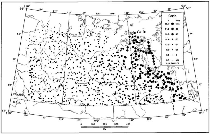
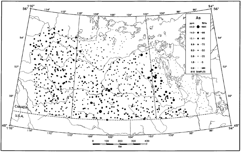 Figure 2 - Concentration of As in the <63 μm fraction of surface till units in the Prairie region.
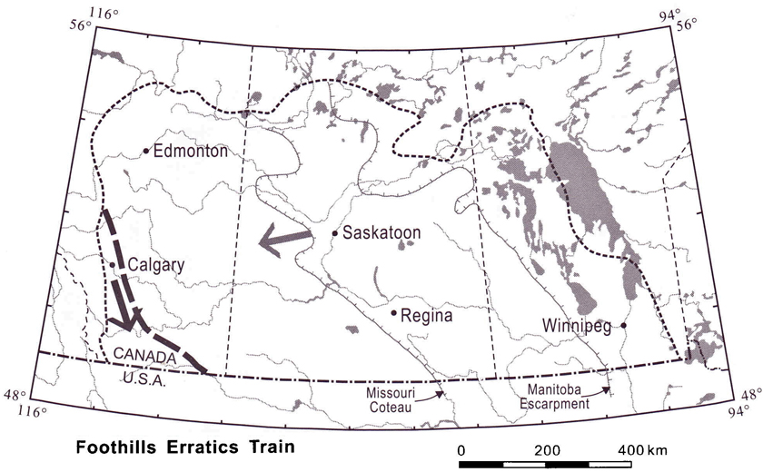
- Coalescent Cordilleran and Laurentide (Shield- derived) ice-deposited sediment of Rocky Mountain provenance in the Foothills Erratics Train (Figure 4; Stalker, 1956). Surface till in this area is characterized by an abundance of grey carbonate clasts, as well as high-matrix carbonate, CaO, P2O5, and, to a lesser extent, MgO levels. This till extends south from the Athabasca River valley to the Montana border, where it swings eastwards to coincide with the McNeill Erratics Train (Klassen, 1989), presumably under the influence of high ground in Montana.
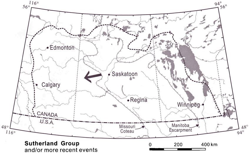
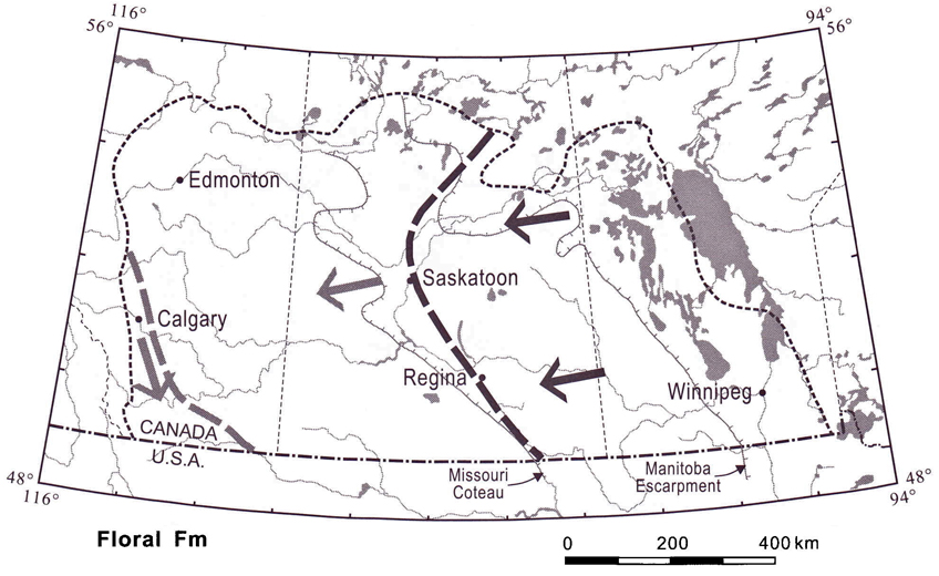
- Southeastern Saskatchewan and southwestern Manitoba are underlain at surface by moderately calcareous till that contains abundant Shield debris, Manitoba carbonate, and siliceous Cretaceous shale from the Manitoba Escarpment. The western limit of this area is the Missouri Coteau (Figure 5), with extensions such as along the South Saskatchewan River. Values for carbonate, CaO and MgO are at moderate levels across the area, whereas elements with an apparent source in the Manitoba Escarpment, including As, Sb, Mn, V, Mo, Zn, and Cd, decrease westward. The composition of this surface till is similar to that of the subsurface Floral Formation in the Saskatoon area (Christiansen, 1992), which underlies the most recent till. The lack of geomorphic manifestations of an ice margin at the limit of this zone suggests that related ice flow extended well into Alberta; hence deposition of distinctive till ceased some distance behind the associated ice front, at the topographic rise of the Missouri Coteau. What is particularly interesting about this unit in southeastern Saskatchewan and southwestern Manitoba is that the surface geomorphology indicates a last ice movement from the north and northwest, while sediment provenance indicates transport from the northeast. This indicates that this later event was not associated with significant sediment transport in this area, and that it simply re-sculpted the landscape to leave northerly directional features on easterly derived materials.
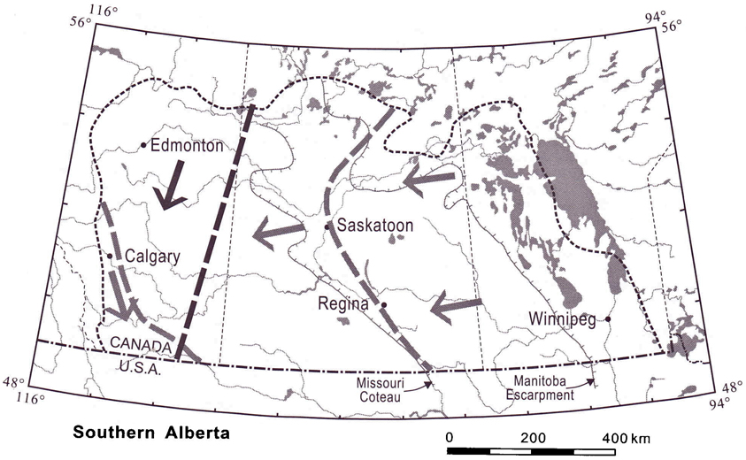
- Till in southern Alberta (Figure 6) differs slightly in composition from that in adjacent Saskatchewan with respect to higher abundances of Shield- derived granite and gneiss, as well as quartz sandstone, possibly derived from the Athabasca Group of northern Saskatchewan. These differences are accompanied by a decrease in greenstone and brown carbonate clasts, further suggesting a northern provenance. Geochemical data from this area are less equivocal and indicate incorporation of local shale into more distantly derived Precambrian, Paleozoic, and Cretaceous debris from the east.
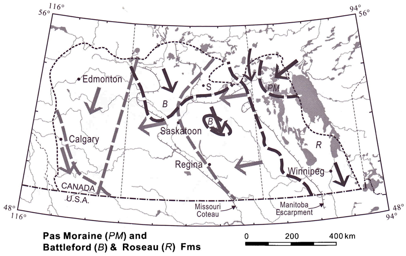
- Till of very distinct composition subsequently was deposited by northerly derived ice in Saskatchewan and Manitoba (Figure 7). In Saskatchewan, surface till north of the North Saskatchewan and Saskatchewan Rivers, and in some restricted areas to the south, is characterized by an abundance of Shield-derived granite and gneiss clasts, garnet, amphibole, and elevated levels of Na2O, K2O, SiO2, Th, and the REEs. In contrast, levels of carbonate, As, Sb, and the U/Th ratio are low. However, they also contain some brown carbonate and shale clasts, and measurable carbonate, indicating that the ice advance from the north entrained some easterly derived material from earlier advances. On the basis of stratigraphic position and ice-flow trend, this till is correlated to the Battleford Formation, the youngest till in the area (Christiansen, 1992). The ice that deposited the Battleford Formation, according to the geomorphological evidence, also swept southeast across southeastern Saskatchewan and southwestern Manitoba. However, it seems to have deposited little material of northwesterly provenance, and only reworked Floral Formation tills south of the Saskatchewan River, with the possible exception of what may be depositional outliers in east-central Saskatchewan (Figure 7). East of the Manitoba Escarpment, highly calcareous till is rich in brown carbonate pebbles, CaO, MgO, and matrix carbonate, but deficient in virtually all other measured variables, especially As. This till, which corresponds to the Roseau Formation of Manitoba (Fenton, 1984) and extends into the US as the tills of the Red River and Des Moines lobes, was deposited by ice flow that was channeled by the Manitoba Escarpment.
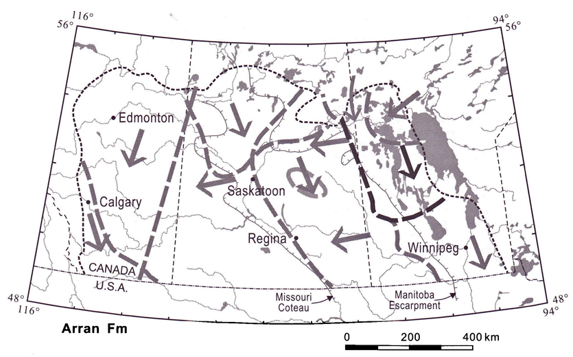
- A shift in heavy mineral abundance may indicate the influence of the Arran event in Manitoba (Figure 8). Epidote and sphene abundance drops abruptly north of a line from Eriksdale to Washow Bay (-51 °N). Again, the ice flow associated with this unit may have extended beyond this boundary, reworking older tills generally attributed to the Roseau Formation. These minerals may reflect a source in the Interlake, or may represent reworking of sediment earlier transported southwestward or westwards from the Shield.
In summary, the composition of tills in the Prairie region does not vary continuously. Instead, step-wise changes occur due to the presence of several relatively homogenized sediment packages. Ice-flow events appear to have generated unique blends of debris, but flow extended beyond where these sediments were contiguously deposited, only to rework older debris.
It is possible to relate these surface observations to subsurface sediments. At Smeaton (see Figure 7 for location), till is divisible into several compositionally distinct packages (Thorleifson and Garrett, in press). The Shield debris-rich and carbonate-poor sediments that occur at surface in the area are present to a depth of 35 m, contrasting sharply to the near absence of northern-provenance till to the southeast, despite the continuity of geomorphic indicators of southeastward flow. Underlying till, also over 30 m thick, is carbonate-rich and similar in composition to the Floral Formation and surface till in southeastern Saskatchewan. This indicates a counter-clockwise rotation of ice flow that caused a shift from eastern to northern provenance till. The lowermost tills at the site, over 30 m thick, are more local in derivation.
The implications of these observations for diamond exploration in the Prairies are important. For example, the absence of kimberlitic indicator minerals in surface tills south of known kimberlite occurrences in the Fort a la Corne area, Saskatchewan, may be due to the fact that the kimberlites were not eroded by the last ice flow, the southeasterly Battleford advance. Rather the erosion products were initially moved westwards, perhaps to the Prince Albert area where an erratic block has been described by Scott-Smith (1995), and later moved southeastwards by the Battleford event. In areas of southeastern Saskatchewan and southwestern Manitoba underlain by Floral and Battleford-reworked Floral tills, the source of indicator minerals in most cases would be to the northeast, and not to the north as indicated by geomorphic features. The exceptions, outliers of northern till, may relate to higher elevation sites. The net effect is a southeasterly displacement of dominantly easterly-derived materials. In southwestern Saskatchewan and adjoining Alberta, local sources are probably far more influential. However, the role of Tertiary gravels in storing indicator minerals from more distant sources to the south in Montana, and/or local sources, has to be considered. In southern Alberta, Rocky Mountain sources must be considered if indicator minerals are recovered from tills of the Foothills Erratics Train. Elsewhere in Alberta, indicator mineral sources to the north and northeast are the most likely. In the eastern part of the survey area where highly calcareous tills are present, source areas to the north, northeast and east must be considered, in addition to local sources.
Christiansen, E.A. (1992): Pleistocene stratigraphy of the Saskatoon area, Saskatchewan, Canada: An update; Can. J. Earth Sci., v28, p1767-1778.
Fenton, M.M. (1984): Quaternary stratigraphy of the Canadian Prairies; in Fulton, R.J. (ed.), Quaternary stratigraphy of Canada - A Canadian contribution to IGCP Project 24, Geol. Surv. Can. Pap. 84-10, p57-68.
Garrett, R.G. and Thorleifson, L.H. (1993): Prairie kimberlite study - Soil and till geochemistry and mineralogy, low density orientation survey traverses, Winnipeg-Calgary-Edmonton- Winnipeg, 1991; Geol. Surv. Can. Open File 2685, 1 diskette.
___ (1995): Kimberlite indicator mineral and till geochemical reconnaissance, southern Saskatchewan; in Richardson, D.G. (ed.), Investigations completed by the Saskatchewan Geological Survey and the Geological Survey of Canada under the Geoscience Program of the Canada-Saskatchewan Partnership Agreement on Mineral Development (1990-1995), Geol. Surv. Can., Open File 3119, p227-253.
___ (1996): Kimberlite indicator mineral and soil geochemical reconnaissance of the Canadian Prairie region; in LeCheminant, A.N., Richardson, D.G., DiLabio, R.N.W., and Richardson, K.A. (eds.), Searching for Diamonds in Canada, Geol. Surv. Can., Open File 3228, p205-211.
Klassen, R.W. (1989): Quaternary geology of the southern Canadian Interior Plains; Quaternary Geology of Canada and Greenland, Chapter 2, Geology of Canada No. 1 (also released as Geological Society of America, The Geology of North America, vK-1), p138-173.
Lehnert-Thiel, K., Loewer, R., Orr, R.G., and Robertshaw, P. (1992): Diamond-bearing kimberlites in Saskatchewan, Canada; The Fort à la Corne case history; Expl. Mining Geol., vl, p391-403.
Schreiner, B. (1990): Lithostratigraphic correlation of Saskatchewan tills: A mirror image of Cretaceous bedrock, Volume 1; Sask. Resear. Counc., Publ. R-1210-3-E-90, p114.
Scott-Smith, B.H. (1995): Geology of the Sturgeon Lake 02 kimberlite block, Saskatchewan; Expl. Mining Geol., v4, p141-151.
Shetsen, I. (1984): Application of till pebble lithology to the differentiation of glacial lobes in southern Alberta; Can. J. Earth Sci., v21, p920-933.
Stalker, A. (1956). The Erratics Train, foothills of Alberta; Geol. Surv. Can., Bull. 37, 28p.
Thorleifson, L.H. and Garrett, R.G. (1993). Prairie kimberlite study - Till matrix geochemistry and preliminary indicator mineral data; Geol. Surv. Can., Open File 2745, 1 diskette.
___ (1997). Kimberlite indicator mineral and geochemical reconnaissance of southern Alberta; in Macqueen, R.W. (ed.), Exploring for Minerals in Alberta, Geol. Surv. Can. Geoscience Contributions, Canada-Alberta Agreement on Mineral Development (1992-1995), Geol. Surv. Can., Bull. 500, p209-233.
___ (in press): Lithology, mineralogy, and geochemistry of glacial sediments overlying kimberlite at Smeaton, Saskatchewan, Canada; in Richardson, K.A. (ed.), Multidisciplinary Studies at Kimberlite Pipe 169, Smeaton, Saskatchewan Geol. Surv. Can., Bull.
Thorleifson, R.G., Garrett, R.G., and Matile, G. (1994): Prairie kimberlite study - Indicator mineral geochemistry; Geol. Surv. Can., Open File 2875, 1 diskette.
Thorleifson, L.H. and Kristjansson, F.J. (1993): Quaternary geology and drift prospecting, Beardmore-Geraldton area, Ontario; Geol. Surv. Can., Mem. 435, 146p.
View the First Page
A text abstract of this article is not available. The first page of the PDF appears below.
You may download the first page as a PDF.

Pay-Per-View Purchase Options
The article is available through a document delivery service. Explain these Purchase Options.
| Watermarked PDF Document: $14 | |
| Open PDF Document: $24 |