About This Item
- Full TextFull Text(subscription required)
- Pay-Per-View PurchasePay-Per-View
Purchase Options Explain
Share This Item
The AAPG/Datapages Combined Publications Database
Williston Basin Symposium
Abstract
EXTENDED ABSTRACT: Interlake Facies & Reservoir, Bryant and Adjacent areas, Southeast Saskatchewan
W. Martindale
W. Martindale Consulting Ltd., Calgary
Barry W. Larson
Nexen Canada Inc, Calgary
Until late 2001, the Silurian Interlake Formation (Llandoverian-Wenlockian) in southeastern Saskatchewan had not been regarded as a significant exploration target, despite a long history of production from equivalent reservoirs in the central portion of the Williston Basin, largely from structural traps along the Nesson Anticline in North Dakota. In November 2001, Nexen Canada Ltd. discovered significant quantities of oil in dolomitic carbonates (Taylorton sub-unit) of the Interlake at Bryant (7-4-5-7W2). Subsequent drilling has proven the commercial viability of this discovery.
In North Dakota, the Interlake has produced 9.22 million m³ of oil (58 MMBO) representing some 4 percent of that state's total production. Prior to the Bryant Interlake discovery, only a handful of Interlake oil shows had ever been recorded in Saskatchewan. The first was in the Mobil N. Redvers 14-19-8-32W1M drilled in 1957. Five drillstem tests were run in the Interlake, with the most successful recovering 30.5 m of oil cut mud and 27.5 m of mud cut oil from the uppermost part of the Interlake (Taylorton Mbr.). A completion was attempted, but the well was eventually abandoned without production. Other wells with Interlake oil shows on drillstem test include, Tidewater Wapella Crown 12-34-14-1W2M (16.8 m of oil and water cut drilling mud), Imperial Douglaston 12-6-5- 3W2M (228.6 m of salt water cut oil) and most recently (1996) Berkley et al Midale 10- 29-6-11W2M (400 m of oil and water cut mud). A few other wells have recovered gas cut water from the Interlake, including Mobile CDR Flat Lake 5-30-1-15W2M, Pan Am OUHL A-l Caron 10-10-17-29W2M, Shell Big Muddy Lake 15-12-3-21W2M and Socony Sohio Briercrest 14-11-14-24W2M. Oil staining has also been identified in a number of cores and cuttings most notably Mark Minton 5-17-3-21W2M where the presence of spotty oil stain and yellow-white fluorescence corresponds to a small gas kick at the top of the Interlake on the striplog.
The discovery well for the Bryant Interlake was the 7-4-5-7W2M well spudded on October 25, 2001 as an Ordovician Red River test. Three zones were tested on penetration in this well including the Frobisher, Ratner Mbr (Winnipegosis Fm.) and the Interlake Fm. All of the tests were successful and oil to surface was recorded in both the Ratner Mbr. and Interlake Formations, suggesting a multizone discovery of some magnitude had been made. No water was recovered from either the Ratner or Interlake test intervals. The well subsequently TD'd in the Winnipeg Shale and addition tests were run in the deeper part of the well after logging. After several mis-runs in the Red River Formation, oil was successfully tested from the Stony Mountain Formation, immediately above the Red River, the first such occurrence of oil from the Stony Mountain in Canada. Intermediate casing was then set and the well deepened to the Precambrian. The Winnipeg Sand proved to be wet and the open hole below the intermediate casing was abandoned. The 7-4 well was subsequently completed as a Red River producer. Upon completion of the 7-4 well the rig was moved some 80 m to the west and the 7-4T-5-7W2 well was spudded on January 2, 2002. This well was drilled to the Ashern and cased. The drilling rig was then moved off, and the well deepened with a service rig to a 2420.5 m (driller TD), or about the base of the Interlake drillstem test interval in 7-4, and completed open hole.
Subsequent tests on the 7-4T well yielded rates as high as 218 m³/d (1370 BOPD) in March of 2002. To date the 7-4T well has produced 17,400 m³ Oil (109,446 BO), and 27,150 m³ water (170,774 BW). Current production is 10.2 m³/d (64 BOPD) at a 97%WC (PetroLab, 2003, data current to January 2003). A third well at 11-4-5-7W2M was drilled in September 2002 to test the limits of the Interlake structure. This well encountered the Interlake some 14 m lower than the 7-4 wells. Although the core has some fracturing and spotty oil stain, drillstem tests of the Interlake recovered only mud. As it appeared the Interlake is too tight off structure to produce, the well was completed in the Mannville as a salt water disposal well. The core displayed is from the 11-4-5-7W2M well. No Interlake cores were cut in either the 7-4 or 7-4T wells.
The Interlake oil is light gravity (851 kg/m³; 34.6 API) with low sulphur and has a relatively low GOR of 140 m³/m³. Compositionally the oil appears identical to Interlake oil from the Nesson Anticline pools. It is also compositionally identical to oil extracted from cores in the Redvers area wells (K. Ozadetz, pers. com. 2002).
Interlake cores from twenty wells in a twelve by twelve Tonwship area (13,000 km²/5000 miles²) centered on the Bryant discovery were examined to determine depositional and diagenetic facies and reservoir quality. Cores were examined in detail, extensively photographed and a suite of 60 thin sections of representative facies and reservoir units made.
Interlake sediments were deposited along the margin of an extensive shallow marine to supratidal coastline in the ancestral Williston Basin. Upper Interlake sediments in Saskatchewan were deposited on an areally extensive tidal flat that was periodically inundated with seawater, then subaerially exposed. Repeated inundation and exposure has resulted in a highly cyclical sequence of shallow hypersaline marine and pedogenic carbonates with variable reservoir quality.
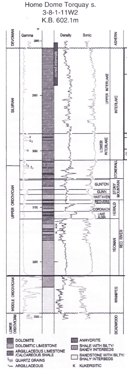
In the area studied, the Silurian consists of a number of sub-units. The lower Interlake consists of the Strathclair, Fife Lake and Guernsey sub-units, none of which were cored. The upper Interlake consists of a lower Cedar Lake sub-unit, seen in four cored wells and an upper Taylorton sub-unit which is the unit most frequently cored in the area examined (Haidl, 1987) (Fig. 1). The contact with the overlying Middle Devonian Ashern Formation is unconformable and possibly diachronous. The unconformity progressively erodes the Interlake towards the north.
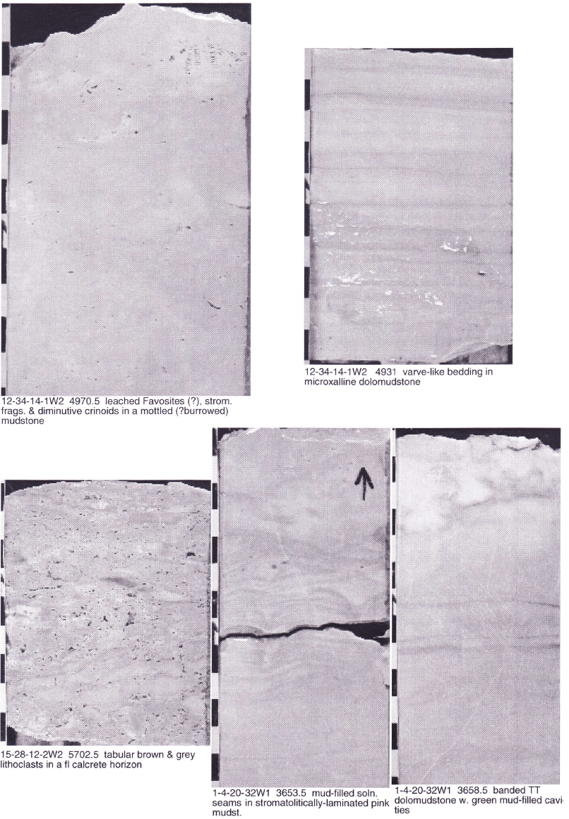
The Cedar Lake consists of banded, laminated & locally stromatolitic pink, red and sometimes yellow microcrystalline-very finely crystalline dolomudstone, sometimes with storm event beds and locally with leached vuggy and fine intercrystalline porosity (Plate 1). They are cyclical in character and were deposited in shallow lagoons that were of relatively normal salinity during the early parts of the cycle but which became increasingly hypersaline towards the end of a cycle. The Cedar Lake was probably deposited in a semi-arid/arid environment similar to that of the modern Persian Gulf.
The Taylorton sub-unit is at least 38m thick in the study area and consists of a variety of cyclical carbonates deposited under subaqueous hypersaline and arid/semi-arid subaerial conditions. Cycles vary from 0.5 to over 3m thick and reflect increasing periods of subaerial exposure towards the end of the Interlake. The Taylorton is sub-divided into four horizons and a number of sub-horizons (Fig. 2).
Horizon A occurs above the base of a typical cycle, which is frequently abrupt and erosional. It consists of either medium grey, sometimes silty, very finely crystalline to microcrystalline dolomudstones with thin, carbonaceous seams and stylolites or of mottled cream or light grey silty/sandy microcrystalline dolomudstone that may exhibit faint root traces (Plate 2A). This may be a bleached equivalent of red rooted mudstones of the horizon above. Horizon A was deposited in areally-restricted low lying areas, on a broad coastal plain or playa that were rapidly inundated by marine waters during a small rise in relative water level. Organic productivity in the water column (perhaps aided by density stratification and minimal convective overturn) rapidly depleted the available oxygen during decomposition, resulting in dysoxic bottom waters and dark laminated sediments that are typical of this horizon.
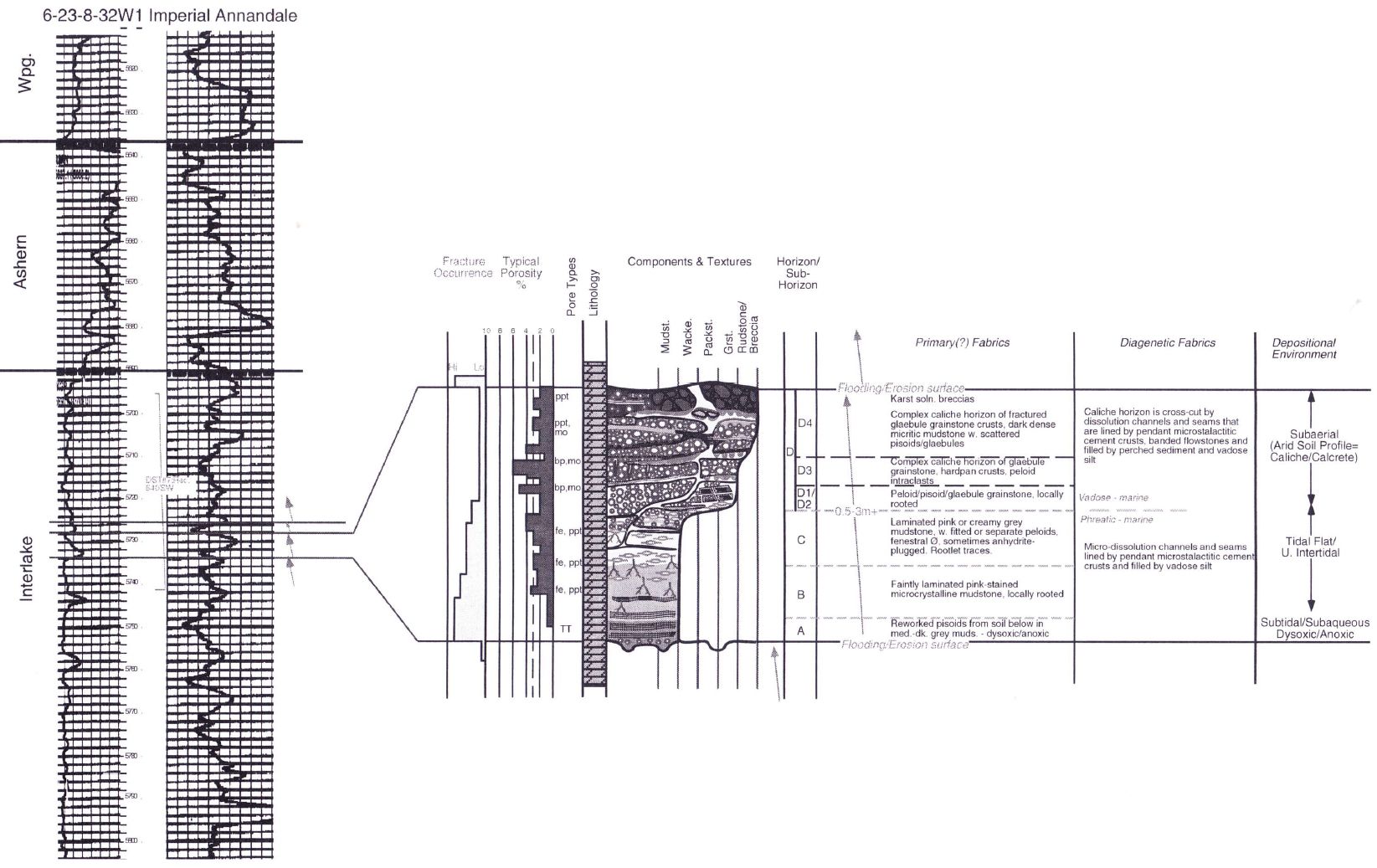 Figure 3. Idealized U. Interlake (Taylorton) Cycle.
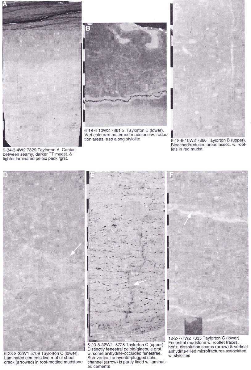
The lower part of Horizon B, which is sometimes gradational with horizon A below consists of darker red or purple microcrystalline to extremely finely crystalline, sometimes silty dolomudstones that exhibit varying degrees of concentric or reticulate colour banding (Plate 2B). The upper part of horizon B is characterized by salmon pink or mottled reddish grey microcrystalline dolomudstones with distinctive, vertically and laterally-oriented lighter pink or light grey channels and seams that are interpreted as root traces (Plate 2C). Sediments were deposited in a low energy sub-aqueous setting, that was probably highly saline, perhaps a playa lake, salt marsh or coastal lagoon. The characteristic red coloration is probably due to iron staining derived from ground waters. Root traces are from primitive land plants that lived in subaerially exposed sediments higher in the cycle.
Horizon C is subdivided into a lower unit of creamy grey microcrystalline mudstones with distinctive root traces, similar to rooted muds in horizon B but without the reddish/pink coloration (Plate 2D) and an upper unit of either mudstones with rootlets and poorly-defined fenestrae or to packstones and grainstones with well-defined fenestrae and peloids, sometimes with a polygonal fitted fabric (Plate 2E). The lower part of horizon C is transitional (mid-upper intertidal) between the subaqueous environment of horizon B and upper intertidal to marginally supratidal environments where fenestral grainstones of the upper part of horizon C were deposited.
A number of well-defined cm-wide sheet cracks are evident in this horizon. They are usually filled with light grey-white microcrystalline mudstone but perhaps their most distinctive features are banded cements, light grey to med/dark brown grey in colour that hang from the roof of the crack (Plate 2F). Similar features are seen in horizon D above and are interpreted as desiccation features that formed during periods of extreme aridity. Cements were precipitated during a short-lived marine phreatic phase and during more extreme periods of marine vadose conditions.
Horizon D, perhaps the most distinctive of the Taylorton horizons, represents a caliche or calcrete paleosol. It is sub-divided into four sub-horizons. Horizon D1 at the base is gradational with horizon C below and consists of dolomitized peloidal or glaebular packstones and grainstones, a metre or so thick, that have a somewhat light to medium light grey mottled or speckled appearance (Plate 3A). Peloids are "poorly- sorted", are composed of very fine to very coarse microcrystalline (=micritic) mudstone, are rounded to polygonal in outline and in many examples have a fitted fabric (Plate 3B & C). Peloids are similar in composition to their host matrix from which they are derived by a process of textural inversion, due to desiccation.
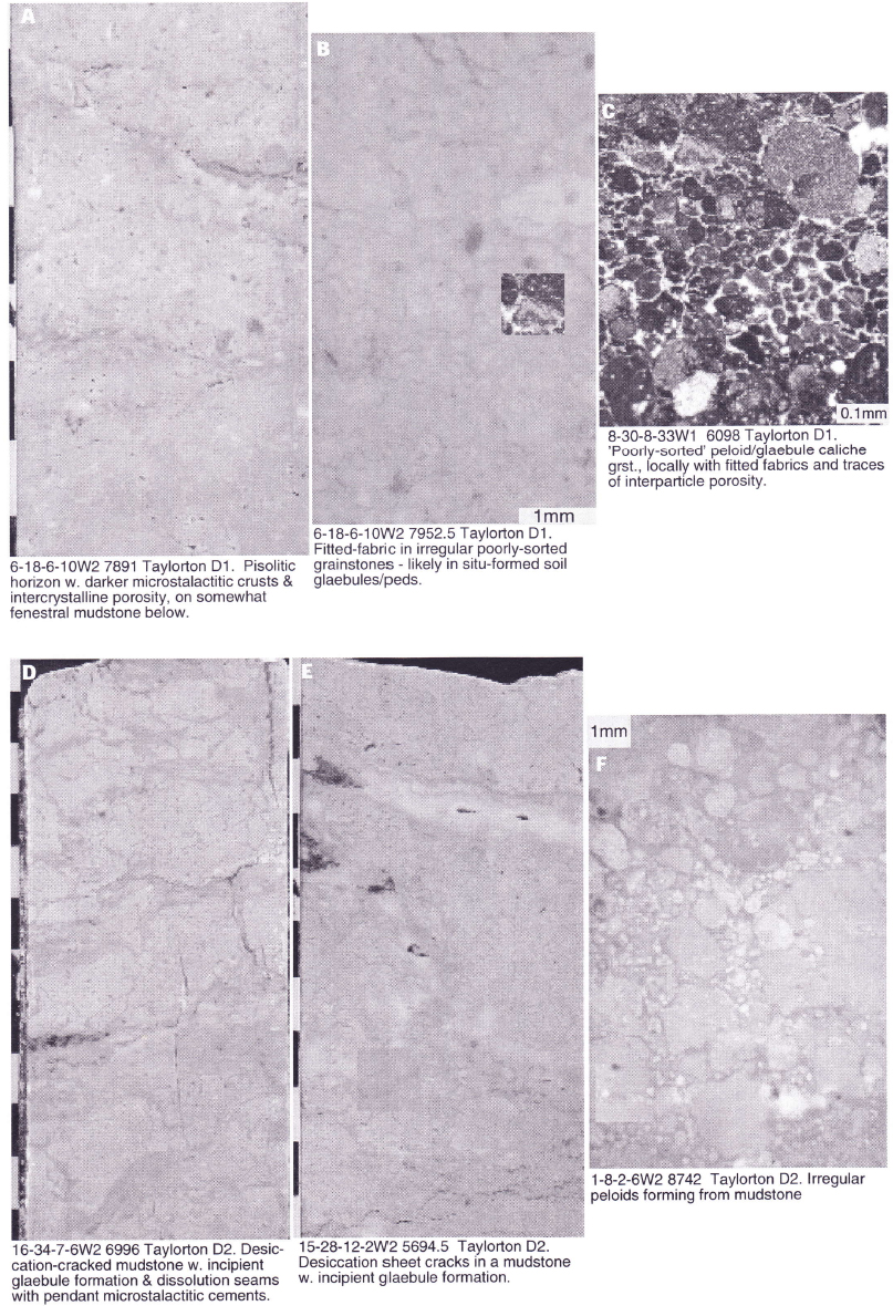
Sub-horizon D2 is usually less than lm thick and is composed of lighter-coloured mudstone or peloid wackestone clasts in a darker microcrystalline to cryptocrystalline mudstone matrix (Plate 3D-F). The overall appearance is of an angular breccia or mud- supported intraclast rudstone. Many of the clasts exhibit a vague development of peloids of various sizes. Breccias are formed in-situ by desiccation, in the lower part of the caliche profile. They may be diagenetically equivalent to sub-horizon D1 grainstones.
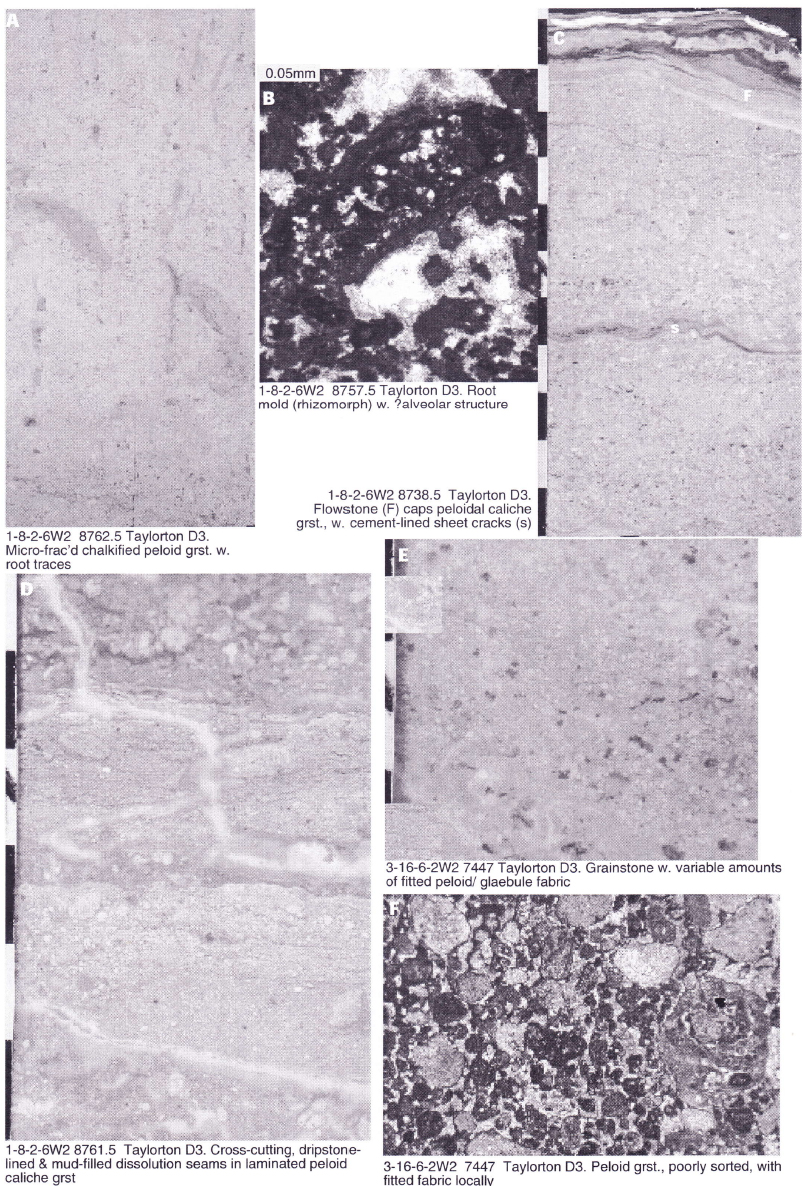
Sub-horizon D3 is usually less than 0.75m thick and is dominated by packstones and grainstones that are poorly sorted, rounded and may exhibit a fitted fabric. They rarely exhibit grading, bedding or laminations. In this they are similar to grainstones of D1. However they lack the speckled character of D1 and in hand specimen appear as a coarse grainstone, sometimes with well-defined root structures that in thin section exhibit alveolar fabrics (Plate 4). Cement-lined and mud-filled sheet cracks are a common diagenetic element in this sub-horizon and seem to be more abundant than in lower horizons (Plate 4C & D). Peloid grainstones are probably of local, in-situ origin, formed by desiccation of pre-existing muds, a process that might have been mediated by soil bacteria &/or fungae. The abundance of cemented sheet cracks suggests that the caliche horizon was subject to longer and more intense periods of desiccation than was the case in lower horizons.
Sub-horizon D4 varies from less than 0.5m thick where poorly developed lower in the Interlake to over 2m in the upper Interlake where it may appear as a complex, undivided succession, many metres thick due to the superposition of numerous thin cycles. It exhibits a complex fabric of dense medium to dark brown microcrystalline to cryptocrystalline dolomudstones containing "clasts", lenses and lumps of lighter grey or tan peloidal, sometimes fenestral grainstones (Plate 5). Grains may exhibit fitted fabrics or may be discreet. Both normal and reverse grading is seen. Cement-lined and mud- filled sheet cracks are less common than in lower horizons. Well-developed pendant cements are common both along sheet cracks and filling individual pores. Sub-horizon D4 represents the uppermost part of the caliche profile and as such probably represents the most extensively altered (?and lithified) part of the profile. It formed under extreme conditions of extended sub-aerial exposure and desiccation.
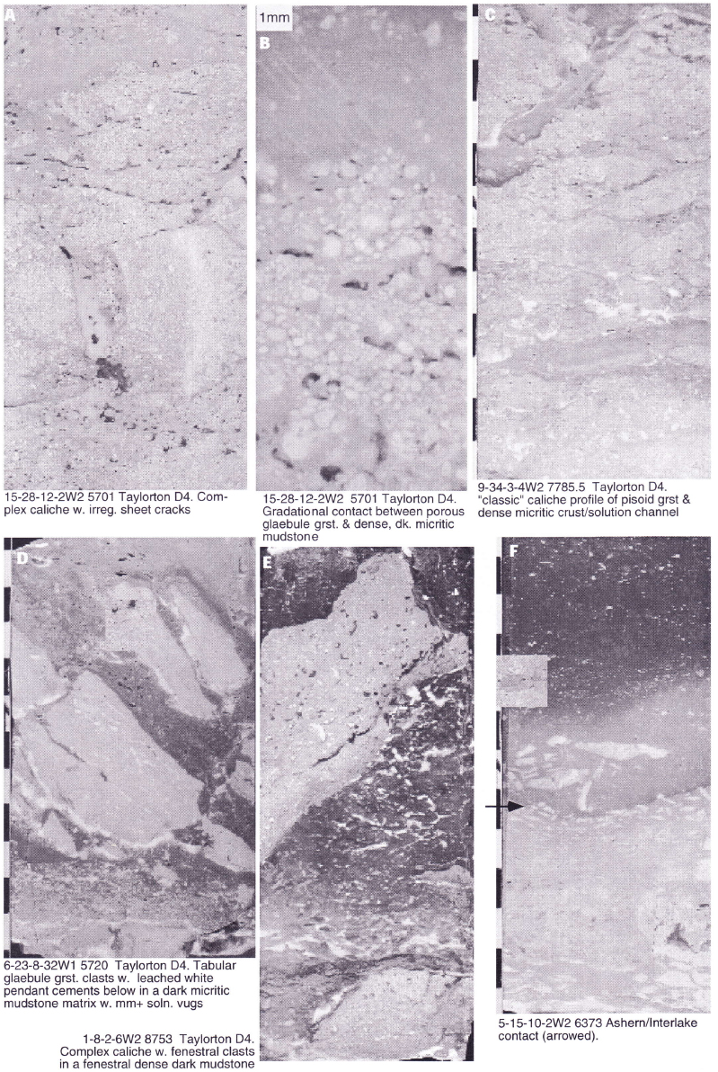 Plate 5. Taylorton Facies & Ashern/Interlake Contact.
Red, orange and grey Ashern siltstones and dolomudstones abruptly overlie the Cedar Lake in the north and the Taylorton sub-unit in the south. The abrupt contact seen on well logs corresponds to a complex, karsted contact with muds and silts of the Ashern infiltrating the Interlake and clasts of Interlake incorporated in the Ashern (Plate 5F). Below the contact, the Interlake frequently exhibits a variety of anastomosing seams and cavities filled with typical Ashern brick red siltstones and mudstones, as well as with grey waxy swelling clays.
The Taylorton is characterized not only by complex caliche horizons but also by multiple stages of diagenetic overprinting. The earliest phase is represented by large-scale fractures that developed during prolonged subaerial exposure. These syn-depositional or very early diagenetic features are, in almost every case, lined by multi-layered cements (Plate 6). Cements form most frequently as pendant, dripstone-like features on roofs of solution cracks and cavities, but are also seen as isopachous cements that line all parts of a cavity. Cements can be simple, consisting of a single layer or few layers of precipitates or highly complex, consisting of multiple layers of a variety of precipitates.
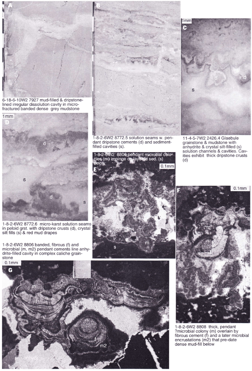 Plate 6. Taylorton Diagenesis.
Earliest precipitates are dark, dense, often micro-laminated, sometimes "clotted" microcrystalline mudstones (Plate 6E-G). Because of their growth habit and dense appearance, they are interpreted as microbial (?micro-stromatolitic) clusters and layers that grew on and hung down from cavity roofs. Bacterial precipitates are likely of marine origin, initially established during a marine phreatic phase, when they formed a relatively continuous crust. Pendant colonies developed later below fractures or beneath permeable zones during a marine vadose phase as water levels receded and cavities dried.
Microbial clusters are overlain by younger cements that vary from thinly banded where they appear to be interbedded with laminar microbial crusts, to thicker banded pendant crusts, to those that are botryoidal (Plate 6F & G). Cements are predominantly pendant in nature but isopachous crusts also form. Thick crusts exhibit a well-defined radial fibrous habit (Plate 6F) and although the nature of the original mineralogy cannot be determined (cements are now mimetically preserved as dolomite), they are assumed, because of their crystal habit, to have been originally marine in origin. They were likely precipitated in a vadose marine setting under arid climatic conditions as sea waters receded and became increasingly saline in character (previous authors have stated that primary cements were precipitated in fresh water vadose and phreatic environments, in a humid climatic setting e.g. Magathan 1987). In some cases, fibrous and botryoidal cements are overgrown by a second (or even third) phase of micritic ?microbial cements. These likely reflect seasonal fluctuations in the salinity (?and temperature) of interstitial marine groundwaters.
Fabrics and textures within the Interlake are exceptionally well preserved and in all of the cores examined, have been mimetically replaced by dolomite. Dolomitization could have been accomplished either by refluxing brines generated on an arid, hypersaline tidal flat during or shortly after Interlake deposition or by a regional high temperature/salinity event during the Interlake/Ashern interval. Further geochemical work is required to substantiate either of the two models.
Later diagenetic phases are relatively minor in occurrence. Anhydrite emplacement locally results in porosity loss and stylolitization may generate short vertical tension fractures. Vertical and sub-vertical tectonic fractures are important locally and vary in abundance and density according to geography and to lithological and textural variations in the core.
Porosity also varies geographically over the study area - the Taylorton at Bryant is relatively tight whereas at Redvers to the east, the Taylorton is quite porous. Porosity is very much facies and fabric dependant. The lowest horizons in a typical Taylorton cycle are mud-dominated and invariably tight (but might be heavily fractured). Porosity is better developed in the upper part of a typical cycle, especially in grainstones of the caliche crust. All types of porosity, both primary and secondary are recognized, but perhaps the most common is vuggy and leached moldic porosity with lesser amounts of interparticle porosity. Much of the primary interparticle, fenestral and fracture/channel porosity has been occluded by multiple generations of carbonate cements and by late- phase anhydrite.
As with many other horizons in Saskatchewan, abundant hydrocarbons have been produced from equivalent Interlake reservoirs in the U.S. portion of the Williston Basin (over 58 million barrels). Four wells in the study area (other than the Bryant discovery well) have tested minor quantities of oil in the Interlake, one of which was completed unsuccessfully. High flow rates were encountered in some wells, but in others some formation damage may have occurred. As Haidl (1995) has stated, the lack of produced hydrocarbons from the Interlake in Saskatchewan may be more a consequence of lack of data rather than lack of hydrocarbons. In this regard, the Bryant discovery is significant and suggests that the Interlake may indeed have reserves similar to equivalent reservoirs to the south.
Haidl, F.M., 1987, Stratigraphic and lithological relationships, Interlake Formation,(Silurian), southern Saskatchewan. In: Summary of investigations 1987, Saskatchewan Geological Survey, Sask. Energy and Mines. Misc. Report 87-4 p. 187193.
Haidl, F.M., 1995, Hydrocarbon potential of Lower Palaeozoic carbonate strata in southeastern Saskatchewan. In: Summary of Investigations 1995, Saskatchewan Geological Survey, Sask. Energy and Mines. Misc. Report 95-4, p. 118-128.
Kreis. L.K. and Haidl, F.M., in press, Geology of the Silurian Interlake Formation in Saskatchewan, Sheet 1, Lower Palaeozoic map Series, Saskatchewan Industry and Resources
Magathan, E.R., 1987, Silurian Interlake Group: a sequence of cyclic marine and freshwater carbonate deposits in the central Williston Basin. In: Fischer, D.W. (ed.), Fifth International Williston Basin Symposium Core Workshop Volume, North Dakota Geological Survey Misc. Series 69, p. 59-88.
View the First Page
A text abstract of this article is not available. The first page of the PDF appears below.
You may download the first page as a PDF.

Pay-Per-View Purchase Options
The article is available through a document delivery service. Explain these Purchase Options.
| Watermarked PDF Document: $14 | |
| Open PDF Document: $24 |