About This Item
- Full text of this item is not available.
- Abstract PDFAbstract PDF(no subscription required)
Share This Item
The AAPG/Datapages Combined Publications Database
Southeast Asia Petroleum Exploration Society (SEAPEX)
Abstract
Abstract: Frontier Sabah Unveiled - Latest Regional 3D Seismic Reveals the Petroleum Potential of Offshore Sabah
INTRODUCTION
The NW Sabah Basin covers an area of approximately 43,000 km2 with marine Tertiary beds typically more than 8 km thick. It receives its major sediment input from the Baram Delta, which is a prolific hydrocarbon province extending from Brunei to NW Sabah, as well as from the Champion and Meligan deltas. Gravity loading and thin skinned deformation has resulted in a fold and thrust belt in the inboard area. This initiated near the shelf in the Mid Miocene, which then propagated north-westward in the Pleistocene. This fold and thrust belt, which hosts turbidite reservoirs within anticlinal structures, has been the major focus and most successful play area in the basin to date.
Further outboard of the fold and thrust belt, beyond the Sabah Trough, lies the NW Sabah Platform, also known as the Dangerous Grounds. It consists of rifted continental fault blocks that split during the opening of South China Sea. Eocene-Oligocene pre- and syn-rift packages that were deposited during this extensional phase potentially host source rocks that could be mature at present-day to charge the overlying mid-Miocene carbonate targets. This Play type was recently tested in the Sabah Trough and was a technical success.
EXPLORATION OPPORTUNITIES UNVEILED
This first ever multiclient 3D survey in Malaysia which encompasses the outer Sabah Thrust Belt, the Sabah Trough and the Dangerous Grounds has a footprint of approximately 37,000 km2 as of today, with more to come. It has become the ultimate explorer’s tool in paving the way to better understand the frontier areas of the greater Sabah Basin. This study has established a new stratigraphic sequence for the Dangerous Grounds and the Sabah Trough based on the high quality measured broadband seismic dataset, which has enabled detailed seismic mapping of the basin fill packages. This has helped better understand the basin development as well as the exploration potential of these outer basins.
At PESGB/SEAPEX London 2018, the author presented the initial geological findings of this frontier basin based on 18,000 km2 of this multiclient dataset. A new basin stratigraphy, various play types and seismic evidence of a working petroleum system was presented. The evidence for a working petroleum system has now been tested and proven by the recent Tepat-1 discovery well.
The continual expansion of this Sabah multiclient dataset enables explorers to further investigate the subsurface and chase these play types further along the fold and thrust belt, Sabah Trough and Dangerous Grounds. Now with a further 19,000 km2 of broadband seismic available, we present further findings and insights from this mega multiclient data of approximately 37,000 km2 that covers the frontier Sabah Basin.
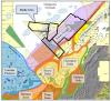 Figure 1. Location map of NW Sabah highlighting the study area. The map also illustrates the various geological terranes
Acknowledgments and Associated Footnotes
1 Dr Tad Choi: PGS, Malaysia; [email protected]
2 Andy Bromley: PGS, Malaysia
3 Ching Tu: WesternGeco, Malaysia
4 Michelle Tham: WesternGeco, Malaysia
Tad is currently a New Ventures Manager for Petroleum Geo-Services (PGS) in their Asia-Pacific headquarters office in Kuala Lumpur. He has nearly two decades working in the oil and gas industry primarily as an explorationist, working with Woodside Energy and then a Principal Geoscientist with PGS. He has interpreted seismic data from regional to prospect scale from most of the prolific hydrocarbon bearing basins throughout NW Shelf Australia and SE Asia.
Copyright © 2019 by Southeast Asia Petroleum Exploration Society (SEAPEX)