About This Item
- Full text of this item is not available.
- Abstract PDFAbstract PDF(no subscription required)
Share This Item
The AAPG/Datapages Combined Publications Database
Houston Geological Society Bulletin
Abstract
Abstract: Geospatial Data Solutions for Site and  Corridor
 Siting Projects
A site or ![]() corridor
corridor![]() selection project is only as good as the data it is built upon. Using ArcGIS products, historical corporate knowledge and publicly available geospatial data, a detailed siting process can be accomplished in a defendable, reproducible, and customizable way. This process will not only identify the most optimum route and/or site, but will also identify potential construction, real estate, and environmental issues associated with the selected sites so that there is adequate time for avoidance or mitigation. This talk will explore some of the frequently accessed public data sources and their uses, as well as a few ArcGIS processes that can help to make the often complex siting processes more automated.
selection project is only as good as the data it is built upon. Using ArcGIS products, historical corporate knowledge and publicly available geospatial data, a detailed siting process can be accomplished in a defendable, reproducible, and customizable way. This process will not only identify the most optimum route and/or site, but will also identify potential construction, real estate, and environmental issues associated with the selected sites so that there is adequate time for avoidance or mitigation. This talk will explore some of the frequently accessed public data sources and their uses, as well as a few ArcGIS processes that can help to make the often complex siting processes more automated.
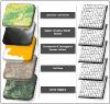 Figure. Using ArcGIS, geospatial data can be easily integrated in ArcMap so that geographic relationships (e.g. proximity and clustering) can be identified and assessed. This illustration represents how data can be overlain in a GIS environment and converted into a single raster format.
Biographical Sketch
Rachel Turney-Work is the National Geographic Information and Socioeconomic Lead at Enercon Services and has more than 15 years experience as a Geographer and Project Manager. During her career, Ms. Turney-Work has completed numerous site selection and site feasibility studies in the United States and United Arab Emirates and has assisted in the development of a geospatial model designed to automate the GIS-based siting processes. Rachel received her BA and MA degrees in Geography from the University of Oklahoma.
Acknowledgments and Associated Footnotes
1 Rachel Turney-Work: National Geographic Information and Socioeconomic Lead Enercon Services
Copyright © 2016 by HGS (Houston Geological Society)