About This Item
- Full text of this item is not available.
- Abstract PDFAbstract PDF(no subscription required)
Share This Item
The AAPG/Datapages Combined Publications Database
Houston Geological Society Bulletin
Abstract
Abstract: Drones - A New Tool for the Environmental and Engineering Geology Professional
The use of UAVs, unmanned aerial vehicles or drones, as they are more commonly referred to, is rapidly growing in many industries including oil and gas. The first drones were used for military purposes. Today, even though there are over 20,000 drones used by various armed forces worldwide, most drones are used for civilian purposes. In a recent report, the estimated number of Enterprise or Commercial-use drone shipments in 2016 was 110,000. This number will reach over 800,000 by 2021. Consumer drone shipments are expected to be around 29 million by 2021.
This talk will briefly cover types of drones, how drones work, and how they are being utilized to solve business problems in a more efficient, safer manner, and at a lower cost than traditional methods. FAA, Federal Aviation Administration, requirements, and regulations will also be covered. Actionable data products generated from drone imagery include high-resolution aerial photos and videos, Orthomosaic (photo maps), digital surface elevation models (DSM, DTM), 3D models, detailed measurements, such as area, volume, length, surface profiles, and infrastructure inspections (optical zoom, thermal imaging). Discuss how drone data seamlessly integrates with other applications, such as GIS, geographic information systems. Specific applications in flood control and surface mining will be discussed. Show some examples of other types of sensors being used on drones including gas leak detection, air quality, Ground Penetrating Radar (GPR) and other geophysical applications.
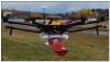 Figure.
Biographical Sketch
Mike Allison holds a BS and MS in Geology. He has 34 years of experience in the upstream oil & gas industry. Mike's experience and background in both Geoscience and IT make him uniquely qualified to recognize how technical solutions can solve E&P business problems. Much of Mike's experience has been focused on leading IT teams directly supporting key E&P departments including Geosciences, Engineering, Spatial/GIS, Land and SCADA. He has worked for different O&G companies including Majors (Gulf Oil and Chevron), Independents (Devon Energy and Fieldwood Energy) and several Service Companies (Exploration Logging, Landmark Graphics, Geoscience Data Management and Moblize).
After leaving Fieldwood Energy, he founded a drone services company named Raptor Aerial Services (RAS). His company provides aerial mapping surveys, stockpile volumetric calculations, inspections, data collection and marketing to a variety of industries. The company provides solutions focused on increasing sales, reducing costs, saving time and improving safety. RAS is fully insured and FAA Part 107 certified.
Mike is an active member of AAPG, HGS and SPE. He has served as the Treasurer-Elect and Treasurer on the HGS Board. As a member of the HGS Continuing Education committee, he conceived and initiated the recording of HGS presentations now available at https://www.hgs.org/multimedia_overview. Last October, Mike taught an HGS Continuing Education Course entitled, "Introduction to Drones (UAVs) for Surveying in the Energy Business". He has made a number of presentations on the use of drones to various industry groups including the Montgomery County Extension Office, Energy Drone Coalition Summit & Expo, HGS Flood Conference and SIPES.
Acknowledgments and Associated Footnotes
1 Mike Allison: Raptor Aerial Services
Copyright © 2019 by HGS (Houston Geological Society)