The AAPG/Datapages Combined Publications Database
AAPG Bulletin
Figure
AAPG Bulletin; Year: 2019; Issue: October DOI: 10.1306/0130191516517255
Return to Full Text
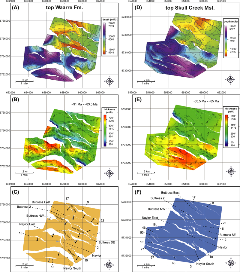
Figure 3. Maps of the two stratigraphic horizons: top Waarre Formation (Fm.) and top Skull Creek Mudstone (Mst.) (modified after Ziesch et al., 2017, and used with permission of Wiley): (A) Depth map of top Waarre Fm. (B) Isochore map of top Waarre Fm. to top Skull Creek Mst. It shows strong fault growth and an increase in thickness toward the southwest. (C) Structural map of top Waarre Fm.; fault heave polygons are shown in white. Black arrows represent the average dip direction, and gray arrows indicate the directions of cylindricity vectors of the faults. See text for details. (D) Depth map of Skull Creek Mst. (E) Isochore map of Skull Creek Mst. to top Timboon Sst. Similar to the underlaying formation, the faults show strong growth thicknesses and the sedimentary thickness increases toward the southwest. (F) Structural map of top Skull Creek Mst. Fault heave polygons are shown in white. Grid coordinate system: Map Grid of Australia, zone 54, Transverse Mercator projection.
Figure 3. Maps of the two stratigraphic horizons: top Waarre Formation (Fm.) and top Skull Creek Mudstone (Mst.) (modified after Ziesch et al., 2017, and used with permission of Wiley): (A) Depth map of top Waarre Fm. (B) Isochore map of top Waarre Fm. to top Skull Creek Mst. It shows strong fault growth and an increase in thickness toward the southwest. (C) Structural map of top Waarre Fm.; fault heave polygons are shown in white. Black arrows represent the average dip direction, and gray arrows indicate the directions of cylindricity vectors of the faults. See text for details. (D) Depth map of Skull Creek Mst. (E) Isochore map of Skull Creek Mst. to top Timboon Sst. Similar to the underlaying formation, the faults show strong growth thicknesses and the sedimentary thickness increases toward the southwest. (F) Structural map of top Skull Creek Mst. Fault heave polygons are shown in white. Grid coordinate system: Map Grid of Australia, zone 54, Transverse Mercator projection.