The AAPG/Datapages Combined Publications Database
AAPG Bulletin
Figure
AAPG Bulletin; Year: 2020; Issue: May DOI: 10.1306/10031919011
Return to Full Text
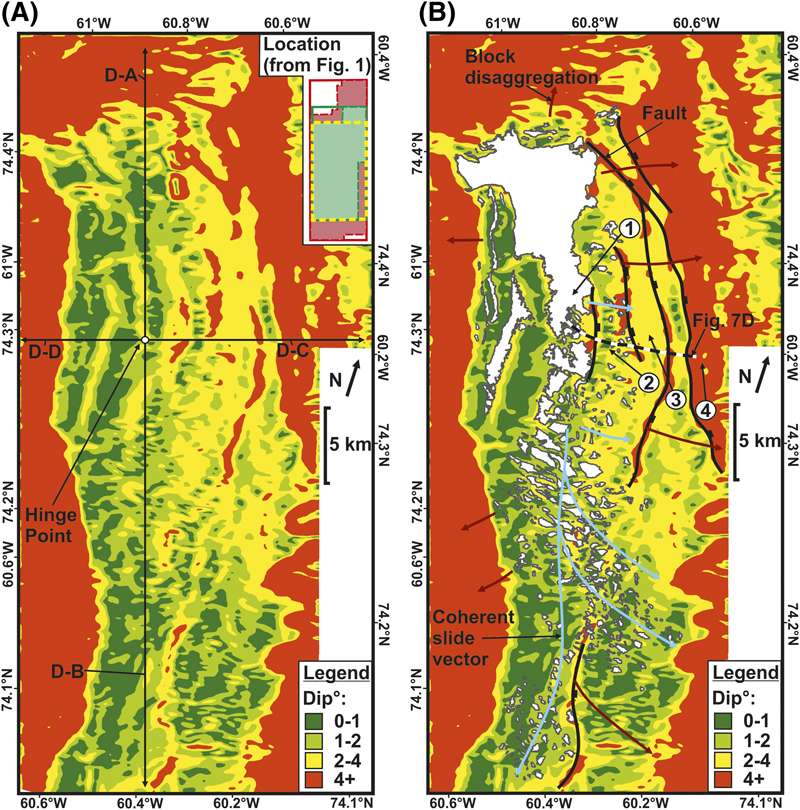
Figure 8. The dip of the decollement surface and its control on block sliding and deformation styles. (A) An uninterpreted dip map of the modern-day reservoir decollement surface (shown in Figure 4) that shows dip increasing away from the relatively flat central axis of the Melville Bay ridge. Four dip transects are shown extending from a central hinge point location on top of the ridge with average dip measurements of 1.6° (D-A), 0.41° (D-B), 3.3° (D-C), and 2.6° (D-D). (B) An interpreted dip map of the modern-day reservoir decollement surface, overlaid by the modern-day distribution of reservoir blocks. The increase in dip downslope (eastward) is shown to coincide with a transition of deformational styles, with areas separated by zones of increased dip created by faults. These zones are numbered on the map and defined as (1) stable platform crest, (2) mega-block sliding, (3) slide scars and disaggregation, and (4) canyonization. The control of the dip on sliding is shown by coherent sliding vectors for visible reservoir blocks (blue arrows) remaining within areas of low dip, whereas areas of steeper dip highlight where the reservoir blocks are not visible with the sand likely having disaggregated and shed downslope (shown by sediment shedding vectors [red arrows]).
Figure 8. The dip of the decollement surface and its control on block sliding and deformation styles. (A) An uninterpreted dip map of the modern-day reservoir decollement surface (shown in Figure 4) that shows dip increasing away from the relatively flat central axis of the Melville Bay ridge. Four dip transects are shown extending from a central hinge point location on top of the ridge with average dip measurements of 1.6° (D-A), 0.41° (D-B), 3.3° (D-C), and 2.6° (D-D). (B) An interpreted dip map of the modern-day reservoir decollement surface, overlaid by the modern-day distribution of reservoir blocks. The increase in dip downslope (eastward) is shown to coincide with a transition of deformational styles, with areas separated by zones of increased dip created by faults. These zones are numbered on the map and defined as (1) stable platform crest, (2) mega-block sliding, (3) slide scars and disaggregation, and (4) canyonization. The control of the dip on sliding is shown by coherent sliding vectors for visible reservoir blocks (blue arrows) remaining within areas of low dip, whereas areas of steeper dip highlight where the reservoir blocks are not visible with the sand likely having disaggregated and shed downslope (shown by sediment shedding vectors [red arrows]).