The AAPG/Datapages Combined Publications Database
AAPG Bulletin
Figure
AAPG Bulletin; Year: 2021; Issue: October DOI: 10.1306/04232120046
Return to Full Text
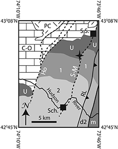
Figure 10.
Generalized geological map of the Schenectady region, New York State. Location of map shown as white-dashed box labeled “Fig. 10” in Figure 2. Dashed bold lines indicate normal fault traces. Solid bold lines indicate Taconic thrusts. Star = approximate location of core discussed in text. Map from Kidd in Jacobi et al. (2016) and modified from Fisher (1980), Plesch (1994), and Kidd et al. (1995). 1 = Ordovician flysch (shale and silt facies of the Lorraine Group), which overlies the Utica Group; 2 = coarser Ordovician flysch of the Schenectady Formation (arenite facies of the Lorraine Group), which overlies unit no. 1; C-O = Cambrian–Ordovician carbonate bank; d2 = deformed Ordovician arenite facies of the Lorraine Group; Ho = Hoffmans Fault; m = Taconic melange; PC = Precambrian rocks; RL = Ruedemann’s Line (western extent of Taconic thrusting); Sch = Schenectady; S-M = Saratoga-McGregor Fault; S.S. = Saratoga Springs; U = Ordovician Utica Group.
Figure 10. Generalized geological map of the Schenectady region, New York State. Location of map shown as white-dashed box labeled “Fig. 10” in Figure 2. Dashed bold lines indicate normal fault traces. Solid bold lines indicate Taconic thrusts. Star = approximate location of core discussed in text. Map from Kidd in Jacobi et al. (2016) and modified from Fisher (1980), Plesch (1994), and Kidd et al. (1995). 1 = Ordovician flysch (shale and silt facies of the Lorraine Group), which overlies the Utica Group; 2 = coarser Ordovician flysch of the Schenectady Formation (arenite facies of the Lorraine Group), which overlies unit no. 1; C-O = Cambrian–Ordovician carbonate bank; d2 = deformed Ordovician arenite facies of the Lorraine Group; Ho = Hoffmans Fault; m = Taconic melange; PC = Precambrian rocks; RL = Ruedemann’s Line (western extent of Taconic thrusting); Sch = Schenectady; S-M = Saratoga-McGregor Fault; S.S. = Saratoga Springs; U = Ordovician Utica Group.