The AAPG/Datapages Combined Publications Database
AAPG Bulletin
Figure
AAPG Bulletin; Year: 2026; Issue: January DOI: 10.1306/11132524122
Return to Full Text
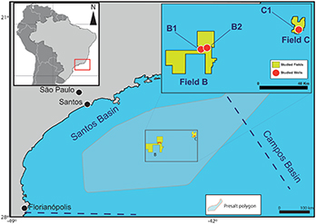
Figure 1. Location map of the Santos Basin, showing the presalt polygon, with an area of 149,000 km2, the studied fields (in yellow), and the wells (in red).
Figure 1. Location map of the Santos Basin, showing the presalt polygon, with an area of 149,000 km2, the studied fields (in yellow), and the wells (in red).