About This Item
- Full TextFull Text(subscription required)
- Pay-Per-View PurchasePay-Per-View
Purchase Options Explain
Share This Item
The AAPG/Datapages Combined Publications Database
CSPG Bulletin
Abstract
The MacKenzie Margin, Southesk-Cairn Carbonate Complex: Depositional History, Stratal Geometry and Comparison With Other Late Devonian Platform-Margins
ABSTRACT
The MacKenzie, or northwestern, margin of the Frasnian (Late Devonian) Southesk-Cairn carbonate platform is exposed along the McConnell thrust (Laramide) approximately 45 km east of Jasper, Alberta. Exposure is approximately perpendicular to the platform margin providing an excellent example of bank-to-basin depositional style at the Cairn (Lower Leduc), Peechee (Upper Leduc), Grotto-Arcs (Nisku), and Ronde (Blue Ridge-Graminia) stratigraphic levels.
The Southesk-Cairn carbonate complex initiated on a regionally extensive shallow-marine platform of the Flume Formation (latest Givetian to earliest Frasnian). The Flume platform overlies a relatively flat pre-Devonian surface and represents an overall deepening-upward sequence. Local evidence suggests that depositionally produced relief (i.e., stacked biostromes) within the Flume, played a fundamental role in the subsequent localization of the Southesk-Cairn platform margin in the Mount MacKenzie area during Cairn time.
The Cairn margin has a transgressive, wedge-shaped profile. It is primarily composed of skeletal grainstones and represents a ramp-style bank-to-basin transition. The Cairn platform phase ended with a brief, but pronounced backstepping event. In contrast, the Peechee margin has a well developed stromatoporoid reef-margin facies, a broad back-reef sand apron and a relatively steeply dipping (about 10°) foreslope facies. The combination of starved sedimentation in the adjacent basin and rapid aggradation of the Peechee reef-margin environment produced up to 200 m of platform-to-basin relief. The Grotto-Arcs strata represent a reef-rimmed margin that developed approximately 3 km bankward of the Peechee margin. The Arcs comprises reef and restricted platform-interior facies, whereas the Grotto represents a distally steepened ramp facies.
Black, anoxic sediments of the Perdrix Formation were deposited adjacent to the northern margin of the Southesk-Cairn carbonate platform and represent a starved basin which developed during Cairn through Peechee and possibly Grotto time according to conodont data. The slow sedimentation rate of the Perdrix strata was replaced by an episode of very rapid basin infill by Mount Hawk sediments. Platform to basin relief was reduced and nearly filled next to the MacKenzie margin during the late Grotto and during a pre-Ronde sub-aerial exposure event. The Ronde margin initiated more than 4 km basinward of the underlying Arcs and then prograded an additional 2 km over lower Mount Hawk strata. It was a reef-rimmed margin with a moderately dipping foreslope facies characterized by a prominent slope buildup and an orange siltstone unit which separates it from the lower Mount Hawk Formation.
A comparison with other outcropping platform-margins indicates that several factors in addition to regional sea level fluctuations influenced the development of these Late Devonian buildups.
RESUME
La marge de MacKenzie, ou du nord-ouest de la plate-forme carbonatee d'age Frasnien (Devonien superieur) de Southesk-Cairn affleure le long du charriage de McConnell (Laramide) approximativement 45 km a l'est de Jasper, en Alberta. L'affleurement est approximativement perpendiculaire a la marge de la plate-forme, fournissant un excellent exemple du style de sedimentation de banc a bassin aux niveaux stratigraphiques de Cairn (Leduc inferieur), Peechee (Leduc superieur), Grotto-Arcs (Nisku), et Ronde (Blue Ridge-Graminia).
Le complexe carbonate de Southesk-Cairn fut initie sur une plate-forme marine peu profonde d'etendue regionale de la formation Flume (Givetien superieur a Frasnien inferieur). La plate-forme de Flume recouvre une surface pre-devonienne relativement plate et, dans l'ensemble, represente une sequence d'approfondissement vers le haut. Des indications locales suggerent que le relief (i.e., biostromes empiles) produit par le depot de Flume, joua un role fondamental dans la localisation subsequente de la plate-forme de Southesk-Cairn dans la region de Mount MacKenzie pendant l'intervalle temporel de Cairn.
La marge de Cairn a une profil transgressif en forme de coin. Elle est principalement composee de grainstones squelettiques et represente une transition de banc a bassin du style rampe. La phase de la plate-forme de Cairn se
1 Geological Survey of Canada contribution number 48991
End_Page 274------------------------
termina par un evenement bref mais prononce de recul. En contraste, la marge de Peechee a un facies de marge recifale a stromatoporoides bien developpe, une large plaine d'epandage sableuse d'arriere-recif et un facies d'avant talus relativement fortement incline (a-peu-pres 10°). La combinaison de la faible sedimentation dans le bassin adjacent et de l'epandage rapide de la marge recifale de Peechee produisit pres de 200 m de relief entre la plate-forme et le bassin. Les strates de Grotto-Arcs representent une marge bordee de recifs qui se developpa approximativement 3 km vers le banc par rapport a la marge de Peechee. Le niveau Arcs comprend des environnements recifaux et d'interieur de plate-forme restreinte, alors que le niveau Grotto represente un facies de rampe devenant plus raide distalement.
Les sediments noirs, anoxiques de la formation Perdrix furent deposes a cote de la marge nord de la plate-forme carbonatee de Southesk-Cairn et representent un bassin a faible remplissage sedimentaire qui se developpa pendant l'intervalle temporel allant de Cairn a Grotto inferieur, d'apres les donnees de conodontes. Le faible taux de sedimentation des strates de Perdrix donna lieu a un episode de remplissage tres rapide du bassin par les sediments de Mount Hawk. Le relief de la plate-forme fut reduit et presque rempli pres de la marge de MacKenzie durant le Grotto superieur et durant une periode d'exposition sub-aerienne pre-Ronde. La marge de Ronde fut initiee a une distance de plus de 4 km de plus dans la direction du bassin par rapport au niveau Arcs sous-jacent et puis prograda encore de 2 km au-dessus des strates de Mount Hawk. C'etait une marge bordee de recifs avec un facies d'avant talus moderement raide caracterise par une accumulation de talus proeminente et une couche de siltstone orange qui la separe de la formation Mount Hawk sous-jacente.
Une comparaison avec d'autres affleurements de marges de plates-formes indique que plusieurs facteurs en plus des fluctuations regionales du niveau de la mer influencerent le developpement de ces massifs devoniens superieurs.
Traduit par Patrice de Caritat
INTRODUCTION
Platform-margin sections of Frasnian (Upper Devonian) carbonate complexes (Fig. 1) are of particular interest to carbonate workers in western Canada. Not only do their fossils, sedimentary structures and textures, lateral facies relationships and stratal geometries provide the best information we have for interpreting their depositional histories, but they are also important reservoir rocks in the Western Canada Basin. Detailed accounts have been written on a handful of classic outcrop sections, although some accounts are only concerned with a particular part of a given margin (Mountjoy, 1980; Andrews, 1988; Morrow and Geldsetzer, 1988). Several other platform-margin sections have been recognized in the eastern Rockies of Alberta and British Columbia, however, no detailed work has been done on them (Geldsetzer, James and Tebbutt, 1989, see references therein).
Andrews (1988) investigated the potential seismic expression of seven outcropping margins from the Leduc level and concluded, "the most important observation made when comparing the [stratigraphic] models at the same scale is the variety of Leduc reef edge morphologies in outcrop". This is an important observation since most of our present understanding of Devonian sea level history is based on the similarities between reef complexes. The observed variability implies that factors in addition to sea level changes affected the development of Late Devonian platform carbonates in the Western Canada Basin.
There is no doubt that relative sea level fluctuations played a primary role in the development of these carbonates. This is evidenced by the fact that a remarkably reliable stratigraphic framework can be applied to geographically separate platforms (Fig. 2). Nevertheless, investigations on the outcrop or reservoir scale can be frustrating because of deviations from the formal, or normal stratigraphy. Yet it is precisely these deviations from the norm that will allow us to unravel the hierarchy of factors which shaped a particular platform -- especially its margin.
Halley, et al. (1983) provides an excellent summary of how multiple factors act in concert to shape the profiles and depositional environments of modern platform margins. Given an equable climate, inherent factors such as the types and relative abundances of different organisms (e.g., binders, encrusters, bioeroders) will affect the depositional character and rate at which carbonate sediment is produced. Paleogeographic factors such as the strength and direction of prevailing winds and paleocurrents in conjuction with antecedent topography will determine where and how carbonate sediments accumulate.
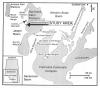 Figure 1. Perimeters of Leduc carbonate platforms/complexes and locations of well-exposed platform-margins (modified from Andrews, 1988).
End_Page 275------------------------
Finally, local and regional tectonics together with eustatic sea level changes will affect the large-scale geometry of carbonate bodies by providing -- or not -- the necessary accommodation space for longterm carbonate deposition.
Evaluating the relative importance of these different factors requires detailed observations from many different and disparate locations. The ultimate goal is to compare and contrast the architecture of the various margins to see if certain platform-margin styles have distribution patterns which can be explained by a combination of the factors mentioned above.
To date, a degree of sophistication has been developed in our ability to locate platform margins and predict general stratal patterns at various stratigraphic levels; a general synthesis is missing. The next logical step is to investigate and compare the depositional architecture of several margins throughout the basin to establish the regional patterns in depositional style and explain such patterns in terms of the relative effects of biological, environmental, paleogeographic, tectonic and eustatic factors.
Although it is difficult to interpret the relative importance of all the factors on different parts of different buildups, we hope to illustrate the prospective utility of documenting the depositional architecture of platform-margins. Results of this paper which deals with the northwestern, or Mackenzie margin of the Southesk-Cairn carbonate complex (Late Devonian, Frasnian) (Fig. 1), are compared with published accounts of other outcropping margins. More work needs to be done in many more areas before there is proper interpretation of the relative effects of those factors which influenced the development of platform margins on local and regional scales.
Finally, as hydrocarbons become harder to find and recover in the Western Canada Basin, it will be increasingly valuable to understand how basin position, local versus regional tectonics, eustacy, prevailing wind and current directions, paleogeography, and biological factors affected the development of a given platform margin.
NORTHERN MARGIN: SOUTHESK-CAIRN PLATFORM
GEOLOGIC SETTING AND PREVIOUS WORK
The Southesk-Cairn Platform is located along the western periphery of an extensive reef domain which developed in the early part of the Frasnian Stage (early Late Devonian) in
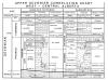 Figure 2. Stratigraphic nomenclature (modified from Geldsetzer, 1987).
End_Page 276------------------------
western and central Alberta. The reef domain occupied part of the western cratonic shelf at paleolatitudes estimated to range from 10°N to 30°N (Ziegler et al., 1979). Whereas the northern areas of the western craton had been transgressed during the late Givetian and early Frasnian by northerly-derived siliciclastic-dominated sediments (Morrow and Geldsetzer, 1988), the southern area was largely protected from this influx by an insular landmass, the Peace River Arch which formed an effective barrier. A broad NNE-trending topographic feature, the West Alberta Ridge, was a southward extension of the Peace River Arch and constituted the western margin of the Western Canada Basin prior to being gradually onlapped and overlapped by a regional carbonate platform -- the Flume Formation -- during latest Givetian to earliest Frasnian.
The Southesk-Cairn Platform (SCP) is one of several large carbonate buildups in the region (Fig. 1) which formed on the underlying Flume platform during the early to middle Frasnian. The northwestern margin of the SCP (the subject of this report) more or less occupied the crest of the West Alberta Ridge, whereas the long southwestern branch of the SCP extended down the western slope of the ridge. In the Rocky Mountains, the Flume Formation is overlain either by a carbonate buildup (Cairn and Peechee) and two post-buildup carbonate banks (Grotto/Arcs and Ronde/Simla) or by deep-marine/basinal sediments (Perdrix and Mount Hawk). Collectively these shallow and deep-marine units make up the Fairholme Group which ranges from the latest Givetian to the latest Frasnian, a span of about 7 m.y. according to Palmer (1983).
Because the reef domain has been investigated both in the surface and subsurface, two sets of nomenclature have evolved. Although there is still a lack of proper biostratigraphic surface-subsurface correlation, a fairly accurate overall lithostratigraphic framework has been established (Meijer Drees and Geldsetzer, 1984) (Fig. 2). The outcrop terminology is used in this paper.
The northwestern margin of the SCP is exposed along five major, westward-dipping Laramide thrust faults in the Front and Main Ranges (MacKenzie, 1965, 1969). The present study was carried out on the leading edge of the McConnell thrust sheet, approximately 45 km east of the town of Jasper, Alberta -- just outside Jasper National Park. The margin of interest is known as the "MacKenzie Margin" since it is located in the area of Mount MacKenzie. Coincidentally, W.S. MacKenzie published the first comprehensive study of this margin in 1965. He established the general stratigraphy and outlined the lithologic character of the different units. Weissenberger and McIlreath (1989) also included stratigraphic and lithologic descriptions of the MacKenzie Margin in their summary of the entire Southesk-Cairn platform.
The Fairholme Group in this area rests on dolomites, red shales, and siltstones of Middle Cambrian age (Aitken, et al., 1972) and although this contact represents a regional angular unconformity, local topography is almost imperceptible. From a distant ridge-top or helicopter, the Devonian section appears slightly darker than the underlying Cambrian, but at close range it is surprisingly difficult to pin-point the actual contact.
The Fairholme Group is overlain by the Sassenach Formation, a siliciclastic unit which filled the western inter-platform basins and even onlapped parts of the older carbonate complexes in the early Famennian. The basal Sassenach contact is conformable with Frasnian basinal sediments, but on the platform the relationship is unconformable. Conodont data, in addition to the occurrence of a conspicuous oncolite unit directly below the Sassenach in this area, reveal the stratigraphic level of the well-known Frasnian-Famennian extinction.
Much of the shallow-marine platform succession is completely dolomitized, but fortunately depositional fabrics are obliterated in only a few cases. The Peechee Member (Fig. 2) is the most poorly preserved unit, whereas basinal, or deep-marine units (i.e., the Perdrix and Mount Hawk Formations), are dolomitized only within several hundred meters of the platform margin. There is a general trend of decreasing dolomite abundance toward the platform-interior in the upper half of the section, but the lower half of the section is completely dolomitized (Shields and Scholle, in prep.).
STRATIGRAPHIC OUTLINE
Stratigraphic sections of all shallow-marine subunits of the Fairholme Group were measured in at least three areas (Fig. 3) to reveal any large-scale lateral zonation. Individual beds were also traced along strike, where exposure and accessibility permitted, to investigate small-scale lateral facies variability. All shallow-marine units, with the exception of the Flume, have a large-scale, depositional facies zonation perpendicular to the platform margin. Significant lateral facies changes also occur on smaller scales (discussed below). Conodont biostratigraphy is used to correlate shallow-marine and basinal units where important lateral transitions are covered or missing and it also provides an estimate of bank-to-basin relief during different stages of platform growth.
Limited lateral exposures of the relatively recessive deep-marine units make it impossible to investigate their lateral facies variations. A nearly complete vertical section of basinal strata immediately adjacent to the MacKenzie Margin, however, comprises a mega-scale shallowing upward sequence. This sequence began with deposition of the lowermost Perdrix Formation and culminated with basinward progradation of the platform margin of the Ronde Member (Fig. 3). With increasing distance from the MacKenzie Margin, however, the basin (Jasper Basin) remained deep throughout the Frasnian and was not infilled until the early Famennian by westerly-derived siliciclastics of the Sassenach (Geldsetzer et al., 1987).
DEPOSITIONAL FACIES: OBSERVATIONS AND INTERPRETATIONS
FLUME FORMATION
The Flume Formation is between 40 and 55 m thick in this area and rests unconformably on Middle Cambrian sedimentary rocks. It represents a regionally extensive shallow-marine carbonate platform and underlies both the basinal and shallow-marine strata of the Fairholme Group (Figs. 2, 3). For convenience, it is subdivided into three, informal stratigraphic
End_Page 277------------------------
units: lower, middle and upper, which document progressively deeper marine environments, respectively.
Lower Flume
The lower Flume overlies the pre-Devonian unconformity in all sections and its thickness varies between 8 and 14 m. It consists of alternating beds of dark grey, Amphipora floatstone and light grey, laminated mudstone (Figs. 4a, b). The laminated mudstone facies has ubiquitous crinkled laminations and in some cases centimeter-scale stromatolitic structures. Rip-up clasts and desiccation cracks are very common at the tops of the laminates and some slabbed samples have dolomitized bedding features indicative of primary evaporites. The Amphipora facies commonly has brachiopods and aberrant bulbous and irregularly-shaped stromatoporoids. In some areas, these fossils are completely silicified. In contrast to the laminates, the fossiliferous beds show no evidence of sub-aerial exposure. Together these facies represent small-scale shallowing upward, peritidal sequences (Fig. 4a). The base of each sequence begins with the Amphipora facies (sub- to intertidal) which grades upward into the laminate facies (inter- to supratidal) which commonly has an erosional top.
Observations from 11 different locations across the entire field area (Fig. 3) reveal that the lower Flume contains between 4 and 7 peritidal sequences which probably represent a broad (>20 km) facies belt encompassing shallow subtidal through supratidal or sahbka facies (Evans, et al., 1969). This analogy suggests that there was very little antecedent topography on the pre-Devonian surface at this time. Since this area underlies the site of a Cairn platform-margin it is reasonable to presume the localization of that margin was not controlled by local topography on the pre-Devonian unconformity.
Middle Flume
The middle Flume is between 30 and 40 m thick and composed of four litho-facies: 1) stromatoporoid biostrome; 2) Amphipora floatstone; 3) skeletal mudstone; and 4) bedded grainstone. It is also characterized by abundant and roughly stratiform chert in its middle part.
The stromatoporoid biostromal facies consists of 1 to 3 m thick biostromes comprised of bulbous or spherical-shaped stromatoporoids. The stromatoporoids, between 5 and 20 cm in maximum diameter, are suspended in a dark-grey matrix, show no evidence of encrustation or binding and are often silicified. Accessory fossils include: Amphipora, Thamnopora, Alveolites, and brachiopods in addition to rare crinoids, wafer-shaped stromatoporoids, and oncolites. Lateral tracing of the biostromes between sections 1 and 6 (Fig. 3) reveals that they are a few hundred meters wide and at their lateral limit either interfinger with, or pinch-out against, one or more of the other litho-facies. The Amphipora floatstone facies consists of 20 to 150 cm thick beds of Amphipora and some Stachyodes suspended in a dark brown-grey micritic matrix. Brachiopods are rare. The skeletal mudstone facies contains brachiopods, Amphipora, gastropods, Thamnopora, rare crinoids and is usually thinly bedded, although some beds are faintly laminated.
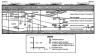 Figure 3. Stratigraphy of the MacKenzie Margin.
End_Page 278------------------------
The bedded grainstone facies is common only in the northern part of the study area and it consists of relatively coarse-grained, horizontal and cross-bedded grainstones (Fig. 4c). Dolomitization has obliterated much of the original texture, but petrography reveals that most grains are skeletal fragments (Fig. 4d).
The middle Flume, in contrast to the lower, contains few inter- and supratidal features indicating that it represents primarily a subtidal environment. Stromatoporoid biostromes are interpreted as broad, low-relief, patch-reefs with areal extents on the order of a few hundred square meters. There was no platform margin in the area during this early stage of Fairholme deposition, and the sheer size of the Flume platform suggests that marine circulation was very restricted. This interpretation is supported by the fact that the overall diversity of organisms in the middle Flume is quite low. Amphipora floatstone and skeletal mudstone beds represent relatively low energy, restricted environments between stromatoporoid biostromes or patch-reefs while rare bedded grainstones represent tidal channels or storm beds.
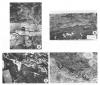 Figure 4. a) Small shoaling upward sequence in the lower Flume. The light-coloured unit in the middle is a dolomitized algal laminate which represents the inter- to supratidal portion of a shoaling sequence; note sharp upper contact and the de-laminated layers. The dark coloured Amphipora wackestone in the upper half of the photograph represents the restricted subtidal facies and the base of the next shoaling sequence (camera lens cap for scale). b) Polished slab of an algal laminate (compare 4a) (sample tag is 3 cm long). c) Herringbone cross-bedding in the middle Flume: evidence for tidal influence (notebook is approximately 10
 ![]() 20 cm). d) Thinsection photomicrograph of completely dolomitized grainstone from the middle Flume. Note the Amphipora grain in the upper right corner. This microfabric is only apparent when the slide is viewed with a translucent piece of white paper placed underneath (photo is approx. 5 cm along the bottom).
20 cm). d) Thinsection photomicrograph of completely dolomitized grainstone from the middle Flume. Note the Amphipora grain in the upper right corner. This microfabric is only apparent when the slide is viewed with a translucent piece of white paper placed underneath (photo is approx. 5 cm along the bottom).
End_Page 279------------------------
Upper Flume
The upper Flume is between 4 and 8 meters thick and, with the exception of Section 10 (Fig. 5), is present throughout the study area (see discussion below). Its fauna is characteristically more diverse -- especially in the northwestern part of the study area -- than in the underlying units and it is usually more recessive. It consists of floatstone to rudstone beds 20 to 60 cm thick with abundant wafer-shaped stromatoporoids, dendroid rugosans, gastropods, brachiopods, Thamnopora, Alveolites, and bulbous stromatoporoids suspended in a dark-gray micrite. It also contains abundant stromatactis cavities.
The upper Flume clearly represents an open-marine environment. The change from relatively restricted (middle Flume) to open-marine deposition was most likely due to a rise in relative sea level which would have promoted more effective circulation across the Flume platform. Ubiquitous stromatactis (c.f. Fig. 6c, upper Cairn) cavities support this conclusion, since they are generally associated with deeper water facies in late Paleozoic carbonates. Lastly, the success of wafer stromatoporoids in this environment can be attributed to their favorable adaptation to greater water depths and lower energy (sub-wavebase?) conditions.
Summary
The Flume Formation, as a whole, represents a large-scale, deepening-upward sequence. It began with a very restricted peritidal environment during the initial transgression. The broad belt of inter- to supratidal facies in the Mount MacKenzie area indicates there was very little topography on the pre-Devonian unconformity surface at the time of transgression. During the middle Flume, water depths increased and shallow subtidal facies became predominant, but a relatively low-diversity fauna in these rocks suggests they represent a relatively restricted environment. It is likely that the Flume platform was laterally so extensive (Fig. 1) that the effective circulation of seawater was significantly curtailed. By the end of Flume deposition, however, continued marine transgression had increased water depths across the platform so that circulation of normal seawater was possible and, as a result, a more diverse fauna developed in the upper Flume.
The Mount MacKenzie area (c.f. Section 10, Fig. 3) was an exception, however. There, the same stromatoporoid biostromal facies which characterized the middle Flume kept pace with sea level rise so that the upper Flume facies was never deposited. By the end of Flume deposition, therefore, a local,
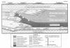 Figure 5. Reconstruction of depositional facies at the MacKenzie Margin.
End_Page 280------------------------
biologically constructed, topographic high had been produced at Mount MacKenzie. This high was instrumental in localizing the platform margin of the overlying Cairn Formation.
As sea level continued to rise, westerly(?)-derived dysaerobic bottom waters transgressed the Flume platform and effectively asphyxiated most biologic environments in low-lying areas, and the diverse communities of the upper Flume were eventually buried by black, organic-rich argillaceous lime-muds of the Perdrix Formation. At the same time, in certain areas such as Mount MacKenzie, biostromal aggradation kept pace with sea level rise, and shallow-marine, carbonate deposition was not interrupted. The subsequent localization of the Cairn margin at Mount MacKenzie was almost certainly controlled by these developments. This sequence of events appears to have played a similar role in the localization of Cairn margins in the Miette carbonate complex (Cook, 1972) and the Ancient Wall carbonate complex (Geldsetzer, 1989).
Two important conclusions can be drawn regarding the demise of the Flume platform. First, the deepening-upward trend recorded in the Flume and, at the same time, increased marine circulation are evidence that marine transgression changed carbonate production. Secondly, open-marine lithofacies which characterized upper Flume deposition north of Mount MacKenzie were transgressed by dysaerobic to anaerobic bottom waters associated with the Perdrix Formation. Therefore, if the upper Flume had any prospect of catching up with sea level, it was thwarted by the introduction of inimical bottom waters during the early asymmetrica conodont zone.
CAIRN FORMATION
The Cairn Formation represents the first phase of differential sedimentation in the region and is, strictly speaking, the basal unit of the Southesk-Cairn platform. Its thickness varies from 120 m at Toma Creek, to 60 m at Mount MacKenzie, and it is absent except for a small mound in the northern part of the study area (Fig. 3). The exact geometry and location of the Cairn margin is not known with certainty, but it pinches out less than 1 km north of Mount MacKenzie where the Perdrix (discussed below) rests directly on the Flume Formation. The Cairn Formation is divided -- informally -- into two stratigraphic units. The lower Cairn is composed of shallow-marine strata and comprises about 95% of the section while the upper Cairn is a conspicuous deeper marine unit and in some ways similar to the upper Flume.
The Cairn is over-thickened by approximately 150 meters in Section 18 (Fig. 3). Two fault-repeated intervals were recognized and these account for 115 meters of the anomaly. One explanation for the remaining "extra strata" is that it represents depositional topography at the Cairn margin, but this produces an anomalous 'bump' in the stratigraphy which cross-cuts depositional facies. An alternative explanation is that the extra 35 m was accommodated by additional, local subsidence as illustrated in Figure 3. This interpretation is favoured because it results in a more realistic profile of the entire margin when the overlying Palliser Formation (Famennian) is used as a datum (Figs. 3, 4).
Platform Interior
South of Toma Creek, the lower Cairn is dominated by thin beds of Amphipora-floatstone and to a lesser degree by horizontally stratified grainstones. Only a few, thin cryptalgal laminates were observed. Grainstone beds appear to be tabular, but exposure is limited so it was not possible to determine the lateral extent of individual beds. They are composed of sand to gravel-sized skeletal fragments of indeterminate origin and very little matrix. Many grainstones contain abundant elongate fossils -- probably Amphipora and Stachyodes -- with a strong preferred orientation parallel to bedding (Fig. 6a). In contrast, floatstone beds contain between 10 and 50% skeletal material which is randomly oriented within a dark dolo-mudstone matrix.
The preferred orientation of fossils in the grainstone facies indicates that they were re-worked by relatively strong current or wave action. They are, therefore, interpreted as tidal channel or possibly storm deposits. The occurrence of algal structures on top of some grainstones suggests they shoaled occasionally into the intertidal environment. The Amphipora floatstone facies is essentially the same as that described from the middle Flume and is likewise believed to represent a restricted, low-energy subtidal environment.
Platform Margin
During the lower Cairn, the margin of the platform was located between Toma Creek and the north side of Mount MacKenzie (Section 11). Here the Cairn is almost entirely composed of skeletal and peloidal grainstones. Only a few thick biostromes composed of bulbous stromatoporoids occur in sections 10 and 11. The predominant allochems are Amphipora, Stachyodes and brachiopods. Pervasive dolomitization has obliterated much of the original fabric of these, but petrographic observations using the enhanced petrographic techniques described by Dravis (1991) indicates that the matrix of the biostromes was primarily skeletal sand (Fig. 4d).
In addition to a few prominent Stachyodes floatstone beds, similar to those described above, Section 11 contains a conspicuous coral floatstone unit and a crinoidal packstone unit. The coral unit occurs at the base of the Cairn just above the upper Flume. It is 4.5 m thick and the basal 50 cm consists of very abundant, dendroid rugosans which appear to be in growth position. The upper part of the unit is essentially a floatstone with a few corals and abundant crinoids. A similar facies was described by Mallamo and Geldsetzer (1991) from the Cairn Formation along the western margin of the Fairholme carbonate complex (Fig. 1).
Reconstruction of the depositional environment at the Cairn margin is problematic because part of the section (i.e., between Mount MacKenzie and Cardinal Mountain) has been eroded. The Cairn margin, however, clearly occurs near Mount MacKenzie, because a complete section of basinal strata occurs less than 1 km to the northwest (Fig. 5). Given that the platform carbonates are more competent and weather-resistant than basin shales, the missing strata are most likely Perdrix. If this is the case, most of the Cairn margin is
End_Page 281------------------------
exposed, and consists of relatively coarse grainstones, and unlike the Peechee, Arcs and Ronde counterparts, does not have a reef-margin facies, but is represented by a ramp-style bank-to-basin transition.
Basinal Cairn: a Failed Mound
As discussed above, the area north of Mount MacKenzie became a basinal environment at the onset of Cairn time. However, in the northern part of the field area near Blackface Mountain (Fig. 5) a lenticular mass of dolostone (approximately 100 m across and 20 m thick) rests on the upper Flume as shown in Section 6 (Fig. 3). A similar, though considerably thicker unit (estimated to exceed 50 m) is exposed within a small klippe on the northeast side of the Cardinal River (Fig. 1). Both exposures probably represent sections through the same lower Cairn buildup (Eliuk and Workum, pers. comm.). A similar buildup in the Deception Creek area is described by MacKenzie (1967). Unfortunately, both these examples were affected by pervasive, fabric-obliterating dolomitization.
Adjacent to the Blackface Mountain buildup, the upper Flume is overlain by debris beds. Some of the debris is normally graded and occurs in channelized beds (Fig. 6b). The occurrence of erosional and gravity-driven structures on top of the Flume indicates that the Cairn Formation aggraded significantly prior to the onset of Perdrix sedimentation -- locally at least. This observation is corroborated by conodont evidence (discussed below).
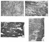 Figure 6. a) Bedding plane view of an Amphipora packstone from the Cairn Formation near Mount MacKenzie (photo represents approx. 10 cm across the bottom). b) Down-cutting into the upper Flume and multiple channel-filling grainstones derived from a lower Cairn buildup near Blackface Mountain (14 cm pencil for scale). c) Stromatactis cavities in the upper Cairn (Section 10); cavities are filled with dark internal sediment and white sparry dolomite. d) Pervasively dolomitized Amphipora(?) grainstone: Peechee Member, back-reef facies (Section 18). Small round pores are probably molds of leached Amphipora grains (vertical dimension of photo is approx. 60 cm).
End_Page 282------------------------
Upper Cairn
The upper Cairn is between 10 and 20 m thick and consists of thin beds of dark micritic dolomite with abundant stromatactis cavities (Fig. 6c). Bulbous and wafer-shaped stromatoporoids, crinoids and Thamnopora are common and in Section 18 many stromatoporoids contain borings whose randomly-oriented geopetal fillings indicate that the organisms were transported -- probably down-slope. The upper Cairn also interfingers with the lower Peechee just south of the Toma Creek area (Section 18, Fig. 3).
The upper Cairn, like the upper Flume, is thought to be a relatively deep, low energy, open-marine unit given the abundance of wafer-shaped stromatoporoids and stromatactis cavities. Since the unit is only present in the southernmost part of the field area (Fig. 5), it is not known where its contemporaneous platform-margin facies was located, although it was certainly south of Nomad Creek. By the end of Cairn time, therefore, the platform-margin had backstepped at least 6 km (i.e., from Mount MacKenzie to somewhere south of Nomad Creek), and the thin open-marine upper Cairn unit was deposited in its place. The upper Cairn, therefore, is a time-transgressive unit and although no diagnostic conodonts were obtained it is very likely equivalent to part of the lower Perdrix.
SOUTHESK FORMATION
The Southesk Formation comprises the upper half of the Southesk-Cairn platform. It contains four members: the Peechee, Grotto, Arcs and Ronde (Fig. 2) and is readily distinguished from the Cairn Formation on the basis of its colour, which is distinctly lighter, with the exception of the Grotto Member. The members of the Southesk define three distinct episodes of platform growth, each of which has a well defined platform margin (Fig. 5).
PEECHEE MEMBER
The platform margin facies of the Peechee Member is almost entirely exposed in the Toma Creek area. A discreet reefal facies exists between Sections 15 and 16, and is flanked by foreslope facies to the northwest and by back-reef and platform interior facies to the southeast (Fig. 5).
Platform Interior
Immediately south of Toma Creek the Peechee is composed entirely of meter-scale, tabular beds of coarse, white dolograinstone and the width of this facies is greater than 500 m. Near Section 18 individual beds are at least several hundred meters wide and maintain a relatively uniform thickness. Although coarse replacement dolomite has obliterated a great deal of the depositional fabric of this facies many beds have a distinct horizontal bedding. Some beds contain abundant centimeter long cylindrical-shaped grains; probably Amphipora, Thamnopora or Stachyodes. The preferred, horizontal orientation of these relatively large allochems indicates they were reworked by relatively strong current or wave action (Fig. 6d). There are also a few fossiliferous floatstones interbedded with the grainstones and these contain Thamnopora, solitary rugosans, Stachyodes and bulbous-shaped stromatoporoids.
Given the size of stromatoporoids and the massive nature of the contemporaneous reef environment (discussed below) it is evident that the Peechee margin was one of particularly high energy. Although the exact mode of deposition of the grainstones in the immediate back-reef environment is not well constrained, the virtual lack of channel-shaped beds strongly indicates that this facies does not represent a system of tidal channels. Apparently the grainstones were deposited as a relatively continuous apron of reef-derived debris either by continuous wave action (i.e., generated by the prevailing winds), periodic washover during storms, or a combination of the two.
Platform Margin
Two important depositional features of the Peechee reef-margin facies can be identified even though it is the most thoroughly dolomitized unit in the study area. It consists almost entirely of lenticular-shaped beds (5 to 20 m wide and up to 2 m thick). The beds themselves contain abundant remnants of very large (up to 1.5 meter diameter) tabular and hemispherical stromatoporoids (Fig. 7a). Each lenticular bed is believed to represent a small patch-reef or bioherm and collectively, they coalesce to form a relatively massive reef facies (Fig. 7b). The enormous size of most stromatoporoids, in addition to their abundance, suggests that this was a particularly high-energy environment. The reef facies is approximately 500 m wide. Unfortunately, this reef has been pervasively dolomitized and it is, therefore, impossible to determine if it was originally cemented by early marine cement.
The migration of the platform-margin facies from south of Nomad Creek to Toma Creek in early Peechee time involved at least 4 km of progradation. It is important to note, however, that the basal Peechee is interbedded with the upper Cairn, indicating that this regression was not facilitated by a major drop in relative sea level. The change from transgression to regression at this time was most likely the result of a marked decrease in the rate of relative sea level rise.
Foreslope
The Peechee strata immediately adjacent to Section 15 are very different from the relatively massive reef-margin facies at Toma Creek. These strata are dominated by decimeter- to meter-scale beds of skeletal packstone and grainstone. At close range there is no apparent slope to the strata, although from a distance the upper half of the Peechee seems to form a 30 to 40 meter thick clinoform which dips between 10 and 15 degrees toward the northwest (Fig. 7c). This section also contains three large, white lenticular beds which pinch out toward the northwest. The lenses are up to 3 m thick and a few hundred meters long. They consist of massive, coarse-grained dolomite with no obvious remnant depositional fabric preserved. Their external form, flat bottoms and irregular tops, however, is consistent with that of debris beds, clearly indicating a slope environment. Northwest of Section 15 the Peechee becomes progressively more recessive and within a kilometer is completely scree-covered.
End_Page 283------------------------
GROTTO AND ARCS MEMBERS
The Grotto and Arcs members (Southesk Formation) are lateral equivalents. The Arcs is variably dolomitized and grey, and the Grotto is completely dolomitized and distinctly darker in colour. The Grotto occurs between Mount Russell and Toma Creek. North of Toma Creek it grades into recessive basinal strata and is largely scree-covered, and to the south, on the eastern face of Mount Russell, it interfingers with the Arcs Member (Fig. 5).
PLATFORM INTERIOR
In the southernmost part of the field area, this stratigraphic level is comprised primarily of Arcs facies limestones, but four conspicuous, meter-scale Grotto beds are present. The lower half of the Arcs consists primarily of peloidal and skeletal grainstones with subordinate pelletal lime mudstones, whereas the upper half contains several thick stromatoporoid biostromes. Sand- to gravel-sized peloids make up the largest proportion of most grainstones and angular as well as abraded fragments of molluscs, brachiopods, Thamnopora, Amphipora, gastropods, crinoids and rugose corals are common. The grainstones are essentially free of micritic matrix and the predominance of point contacts between grains indicates these rocks have undergone only minor compaction. Many are horizontally bedded. In contrast, mudstones have abundant micritic matrix and calcite-filled fenestrae. They are primarily composed of pellets, and like the grainstone, incurred only minor compaction.
The pelletal mudstone facies likely represents a low-energy, restricted, subtidal or tidal flat environment. Fossiliferous grainstones, on the other hand, represent a relatively high-energy environment as evidenced by horizontal bedding, abraded fossil fragments, and a general lack of micritic matrix. The latter is probably a back-reef facies, but unfortunately, the Arcs forms an inaccessible cliff north of Section 19 so this hypothesis could not be verified. However, given the very resistant nature of the reef facies in the upper Arcs (discussed below) it is reasonable to assume that the same facies forms the cliff on Mount Russell (Fig. 5).
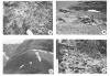 Figure 7. a) Extremely large, hemispherical-shaped stromatoporoid from the Peechee reef-margin facies (Section 15) (water canteen at base is approx. 12 cm wide). b) Exhumed bedding planes of Peechee reef-margin facies (Section 15). Note the domal aspect to these surfaces. Individual domes apparently represent low-relief bioherms, and collectively these comprise the massive reef-margin facies (2 m man for scale). c) Clinoforming bed (arrow lies parallel to foresets): Peechee foreslope facies. Foresets dip to the WNW (arrow represents approx. 50 m). d) Stromatoporoid biostrome from the Arcs reef-margin facies (Section 20). Undolomitized tabular and spherical-shaped stromatoporoids have negative relief relative to the pervasively dolomitized matrix (upper half of a 1.5 m pogo-stick for scale).
End_Page 284------------------------
Platform Margin
The upper Arcs, in Sections 19 and 20, is composed primarily of stromatoporoid biostromes. Biostromal beds are very resistant, but unlike their lenticular counterparts in the Peechee, these biostromes are laterally more extensive; in Section 20 individual biostromes are up to 100 meters wide. Tabular-shaped stromatoporoids are predominant in these units, while the more spherical and hemispherical growthforms which dominate in the lower Fairholme are much less common (Fig. 7d). The tabular stromatoporoids are between 5 and 15 cm thick, and 20 to 40 cm across. Some irregularly-shaped stromatoporoids appear to mimic the substrata on which they grew and may have been encrusters.
These biostromes are also believed to represent broad, low-relief, patch-reefs which collectively formed a legitimate reef-margin facies. The abundance and robustness of tabular stromatoporoids in this facies suggest a high energy environment. Its comparatively narrow apron of coarse, back-reef grainstone, however, suggests conditions were not as vigorous as for the Peechee margin.
Platform Foreslope
The stratigraphic interval between Sections 18 and 15 consists of thin beds of grey-brown dolomite with abundant colonial corals which typify the Grotto Member. Corals include robust branchers and head-shaped varieties, as well as delicate
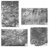 Figure 8. a) Grotto floatstone, low-energy, subtidal slope facies. Abundant wafer-shaped stromatoporoids, Thamnopora, solitary rugosans and stromatactis cavities (1.5 m pogo-stick for scale). b) Large downslope buildup (A): Ronde foreslope facies approximately 500 m south of Section 8. Note forereef debris beds (B) and 2 siltstone beds (C) which mark the base of the Ronde as well as the base of the upper Mount Hawk (thickest part of the buildup is estimated to be 50 m). c) Debris bed with fragments of stromatoporoids and colonial corals derived from the buildup (illustrated in 4b). d) Normally graded oncolite bed: uppermost Ronde (Section 8) (sample tag 3 cm long).
End_Page 285------------------------
branchers (Syringopora?). In addition to the colonial corals, crinoids, brachiopods, gastropods, solitary rugosans, Thamnopora, and wafer-shaped stromatoporoids are common (Fig. 8a). Stromatactis cavities are also common in Section 15. North of Section 15, the Grotto becomes progressively more recessive as it gradually merges with basinal strata.
The occurrence of a few Grotto beds within a predominantly Arcs section at Nomad creek suggests that the lateral transition from the reef-margin facies (Arcs) to the slope facies (Grotto) was very gradational; unfortunately the exact geometry of the transition is poorly known because most of it occurs along an inaccessible cliff on Mount Russell (Figs. 3, 5).
The diversity and abundance of fauna in the Grotto is indicative of an open marine environment, while the abundance of micritic matrix suggests that energy conditions were relatively low -- most likely below wave-base. The Grotto, therefore, represents a very broad, gently-dipping open platform or distally-steepened ramp facies, whereas the Arcs represents a reef to back-reef facies belt. Lastly, water depths across the Grotto facies increased basinward. At Toma Creek (Section 15) water depths increased rather abruptly basinward of the underlying Peechee margin and the Grotto passes very gradually into basinal strata (Figs. 3, 5).
RONDE MEMBER
The Ronde Member represents the final growth phase of the Southesk-Cairn platform and is characterized by a significant progradation of the platform margin environment. It consists of a thin basal unit of silty dolomite and an upper, vertically and laterally zoned limestone unit. The Ronde as a whole thins from about 100 m in the foreslope environment, to 80 m at the platform margin, to less than 60 m toward the platform interior (Fig. 5).
Basal Siltstone Unit
The basal Ronde siltstone represents the first significant influx of siliciclastic sediment onto the northern margin of the Southesk-Cairn carbonate platform. It varies in thickness from 0 to 12 m from north to south across the study area and, in general, becomes finer grained as well as more calcareous toward the platform interior. It consists of thinly laminated, light-brown, silty dolostone or very fine grained, calcareous quartz sandstone. Ripple drift cross-laminations and desiccation cracks are common, but algal laminations were only rarely observed. A few samples have a very conspicuous pinkish-red stain which may be root-casts.
The entire unit is missing (apparently by erosion) between Toma Creek and the south side of Mount MacKenzie, so that the upper Ronde limestones sit directly on dark coloured dolostones of the Grotto Member (Fig. 5). In this area the Grotto-Ronde contact is very sharp and iron-stained. These relationships, together with lithological evidence for very shallow-marine deposition, strongly suggest that this area was subaerially exposed prior to deposition of the upper Ronde.
Platform Interior
South of Toma Creek the Ronde consists almost entirely of decimeter- to meter-thick pelletal or peloidal grainstones and mudstones. A few fossiliferous floatstones are present in the lower half of the Ronde in Section 18 and these contain a sparse, low-diversity faunal assemblage including gastropods and calcispheres, as well as rare forams and Thamnopora. A few fine-grained quartz sandstone units are interbedded with the limestones. The yellow-orange sandstones are ripple cross-bedded and very similar to the overlying Sassenach Formation.
The near lack of fossils in the platform interior facies of the Ronde suggests it was a very restricted environment, and the preponderance of grainstone rather than mudstone lithologies suggests that moderately high-energy conditions prevailed. This apparent contradiction of environments is alleviated if the grainstones represent periodic storm deposition in an otherwise restricted platform interior environment.
Platform Margin
The locus of platform margin deposition was located during the Arcs at Nomad Creek and shifted during the initial stages of Ronde deposition to Toma Creek. Subsequent basinward progradation shifted the margin an additional 2 km to the northwest. As a result of this basinward progradation, the Ronde represents a large-scale, shallowing upward sequence (Fig. 5).
Unfortunately, the reef-margin facies is easily accessible in only one section (Section 16) and forms a massive cliff farther to the north. At Section 16, however, the Ronde consists of massive biostromes which contain abundant stromatoporoids with varied morphologies: spherical, hemispherical, laminar and encrusting. Large, massive head-corals are also common, as are interbedded skeletal and peloidal grainstones. Corals are especially abundant on the open-marine side of the margin (i.e., Section 11). In some cases biostromes change laterally to skeletal grainstones over a few tens of meters. Thus, the reef-margin facies consists of stacked biostromes with interbedded grainstones. In Section 16 the reef facies gives way up-section to restricted back-reef deposits indicating the locus of biostromal deposition prograded basinward during Ronde time. By the end of Ronde time the platform-margin facies had migrated 2 km to the north side of Mount MacKenzie.
Thamnopora, gastropod, Megalodont, and solitary rugose-bearing pelletal grainstones and floatstones occur between the more massive biostromes. Four very prominent quartz arenite units, each a few meters thick, occur in Section 11 (Shields and Hedinger, 1990). It is interesting to note that carbonate deposition was only temporarily interrupted -- not terminated -- by these siliciclastic episodes
Foreslope
The Ronde Member is thickest along the eastern face of Mount Cardinal where it grades imperceptibly into the upper Mount Hawk Formation (Fig. 5). This section represents a foreslope environment and is characterized by a prominent down-slope buildup (approx. 100 m wide by 50 m thick; Fig. 8b). Although the buildup itself is inaccessible, a few debris beds which can be visually traced onto its flanks, contain large irregular-shaped stromatoporoids and colonial corals. Many
End_Page 286------------------------
beds contain angular clasts and have abundant early marine cement, indicating the buildup was lithified early (Fig. 8c).
Two conspicuous, orange-tan coloured siltstone beds (Figs. 3, 5) mark the base of the Ronde Member in Sections 7 and 8. The siltstones are collectively referred to as the "Silt Doublet" (Workum and Hedinger, 1987). It is impossible to trace these beds directly onto the platform because of a large erosional gap in the section between Mount MacKenzie and Mount Cardinal, but based on their stratigraphic position they are most likely stratigraphically equivalent to the basal Ronde siltstone of the platform interior facies (MacKenzie, 1965, 1969). Conodont evidence (discussed below), although not conclusive, is consistent with this interpretation.
PERDRIX FORMATION
The Perdrix Formation is well exposed only in two stream beds on the northeastern face of Cardinal Mountain where it consists of approximately 75 m of dark grey, argillaceous limestone. It comprises alternating thin beds of internally massive, relatively resistant limestone and very recessive, argillaceous limestone. The tops of the massive limestone beds are either sharp or transitional with overlying argillaceous beds, while the tops of the argillaceous beds are always sharp and often marked by down-cutting or loading structures. Massive limestone beds contain a few brachiopods and crinoids and, in some cases, have large trace fossils at their bases. Only rare trace fossils were observed in the argillaceous interbeds. Fine-grained, disseminated, and coarser nodular and replacement pyrite are common throughout the Perdrix.
Superimposed massive and argillaceous beds represent depositional couplets. The massive limestone portions are believed to represent carbonate mud deposited by mass wasting (low density turbidity currents?), while the argillaceous beds represent hemipelagic, background sediment derived from distal sources. In the lower Perdrix, the limestones and the argillites have similar and relatively consistent thicknesses (15 to 20 cm), but in the upper Perdrix, the limestone beds are much thicker and more lenticular in cross-section and the argillaceous interbeds are volumetrically subordinate. More than 100 depositional couplets were measured with thicknesses ranging from 15 to 150 cm.
The bottom half of the Perdrix apparently represents the distal edge of a turbidite deposit (the three-dimensional shape of which is not known), while the more lenticular-shaped limestone beds in the upper half represent channelized deposits. The up-section evolution from thin, parallel to channelized bedding of the limestone litho-facies most likely reflects contemporaneous development of the adjacent carbonate platform. During the early Perdrix, incremental backstepping of the Cairn margin and concomitant increase in platform-to-basin relief (discussed above) progressively isolated the basinal environment so that only the distal portions of platform-derived turbidity currents reached the area of sections 7 and 8 (Fig. 5). As transgression gave way to regression in early Peechee time, however, the MacKenzie Margin achieved its steepest profile and as a result, larger volumes of coarser carbonate debris were shed into the adjacent basin. Evidently as this basinward out-building of the platform progressed, carbonate turbidites traversed the lower-slope environment via shallow channels. This interpretation is analogous to the bypass-slope facies model discussed by MacIlreath and James (1984).
Finally, the general absence of infauna, abundance of pyrite, and preservation of organic carbon (up to 4.9 wt. per cent) strongly suggest that the Perdrix represents a dysaerobic to anaerobic depositional environment.
MOUNT HAWK FORMATION
The Mount Hawk Formation, like the underlying Perdrix Formation, is primarily composed of lime mudstone derived from the adjacent platform. Hence, the contact between the formations is not as lithologically distinctive as it is elsewhere in the basin (McLaren, 1955). In the study area, however, there is an abrupt change in depositional style approximately 75 m above the top of the Flume Formation. At this level the strata abruptly change from alternating limestone mudstone beds described above to more uniform strata of thinly bedded, slightly nodular lime-mudstones. This depositional change is tentatively taken to represent the Perdrix-Mount Hawk contact. Using this contact, the Perdrix is 75 m thick and the Mount Hawk has a total thickness of approximately 210 m. The authors are aware of the subjective nature of the Perdrix-Mount Hawk contact which has commonly been placed at a facies change from dark gray to black anoxic sediments below to medium gray to greenish gray oxygenated sediments above. This facies change is not apparent in the study area. The chosen contact, however, is consistent with the conodont data discussed below.
The Mount Hawk is subdivided into upper and lower units, which are believed to be distinct in terms of their depositional history. The upper Mount Hawk is laterally equivalent to the Ronde Member, whereas the lower Mount Hawk is believed to be a basinally restricted unit (sensu Workum, 1983) that accumulated primarily during sub-aerial exposure of the platform prior to Ronde deposition. The lower Mount Hawk consists of thin, slightly nodular beds with abundant brachiopods and tentaculites. Like the underlying Perdrix, disseminated pyrite and pyritized fossils are common. Dissolution of the carbonate fraction of a few samples indicates that clay comprises upward of 30 to 50 weight per cent. The lower Mount Hawk represents a moderately deep, open-marine environment where siliciclastics as well as locally produced carbonates were deposited. Upon re-emergence, the platform was once again the site of shallow-marine deposition. A relatively thin, mixed carbonate-siliciclastic unit, tentatively referred to as the Calmar, was deposited. The siliciclastic component consists of clay and silt, but a few beds contain fine-grained quartz and feldspar. The siliciclastics are estimated to comprise no more than 30% of this unit. The fact that siliciclastics were able to transgress the platform at this time indicates that much of the bank-to-basin relief that was present at the end of the Grotto-Arcs phase was infilled by this time.
End_Page 287------------------------
In Sections 7 and 8 a conspicuous siltstone unit, the "silt doublet" was also deposited. It consists of two distinct orange-coloured calcareous siltstones, separated by a thin recessive lime mudstone (Fig. 8b). Unfortunately its original sedimentary structures were obscured by bioturbation. Although these two siltstone units cannot be directly correlated with the lower Ronde Siltstone or Calmar since there is a gap in the section between Mount MacKenzie and Cardinal Mountain (Fig. 3), they occur at roughly the same stratigraphic height and are, therefore, tentatively correlated. MacKenzie (1969) reached a similar conclusion.
In contrast to lower Mount Hawk, upper Mount Hawk is a richly fossiliferous unit containing brachiopods, solitary rugosans and Thamnopora in the lower portion, and very abundant colonial rugosan and tabulate corals toward the top. A few meter-thick breccia beds (Fig. 8c) are revealed by the occurrence of broken and overturned coral heads. Petrographic examination of these corals shows fringes of early marine cement. These beds were almost certainly derived from a large Ronde bioherm located approximately 200 m along strike. The uppermost Mount Hawk in the Cardinal Mountain area is composed almost entirely of oncolites. The oncolites range from millimeters to two centimeters in diameter. The oncolite unit is thinly bedded; some beds exhibit well developed normal grading (Fig. 8d). It is proposed that the abundance of oncolites at the top of the Fairholme Group is related to the demise of grazing organisms during the Frasnian-Famennian extinction event.
CONODONT BIOSTRATIGRAPHY
Lateral correlation of Late Devonian carbonate platforms and contemporaneous basinal strata is difficult for a number of reasons. Basinal strata are much more susceptible to structural deformation than the thick sequences of Paleozoic carbonates. Basinal strata are also more liable to be eroded and, therefore, are scree-covered or entirely removed. As a result, there are few outcrops where it is possible to trace platform strata directly into contemporaneous basinal units. Such perfect exposures are not available in the study area. Therefore, platform-basin correlation needs to be supported by conodont data.
T.T. Uyeno of the Geological Survey of Canada identified the conodont collections from the study area (pers. comm., 1991) and zoned them according to the scheme established by Klapper and Lane (1988). Klapper and Lane (1988) did a comprehensive conodont biostratigraphic study of the Perdrix and Mount Hawk strata at Mount Luscar and Mount Haultain (Fig. 1) and concluded that the standard conodont zonation for the Frasnian (Ziegler, 1971) cannot be applied in the Western Canada Basin. Klapper and Lane (1988) outlined an alternate zonation consisting of five informal zones (zones 1 to 5, Fig. 9) and three faunal intervals (zones 6 to 8). Their results indicate that at Mount Luscar the Perdrix Formation contains conodonts from the top of zone 1 to the lower part of zone 5a, while the Mount Hawk Formation ranges from the lower part of zone 5a to the top of zone 7. This suggests that the Perdrix represents a longer period of time even though it is the thinner unit of the two. Similar results were found in the present study and these findings were used in the lateral correlations between platform and basinal strata (Figs. 3, 9). Notwithstanding, it must be pointed out that the Perdrix Formation is a time-transgressive unit and that the upper Perdrix beds in this area could be contemporaneous with the lower Mount Hawk Formation elsewhere in the Western Canada Basin.
Although this is not a comprehensive conodont study, diagnostic species from several key samples provided the means to make a number of important stratigraphic correlations (Figs. 3, 9).
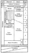 Figure 9. Chronostratigraphic interpretation of the Mackenzie Margin stratigraphy. Conodont zonation corresponds to Klapper and Lane (1988).
End_Page 288------------------------
The upper Flume in Section 18 contains a Lower asymmetrica assemblage, thus assigning the final stage of the Flume platform to zone 1. The oldest Perdrix beds in Sections 5 and 7 rest directly on the upper Flume and also contain zone 1 conodonts (Klapper and Lane, 1988). Therefore, the demise of the Flume platform and the onset of Perdrix deposition occurred within the same conodont zone.
In Section 11, the basal Perdrix contains zone 4a-5b conodonts where it directly overlies the Cairn Formation. Zone 4a-5b conodonts were also identified from a sample taken 20 m above the base of the Perdrix in Section 7. This indicates that the Cairn platform had aggraded at least 60 m while only 20 m of Perdrix accumulated in the adjacent basin (Fig. 3). Unfortunately, no diagnostic conodonts have been recovered from the upper Cairn in the southern part of the study area.
Conodonts from Zone 5a-5b were identified from a sample approximately 75 m above the base of the Perdrix in Section 7. Samples from the basal and middle Grotto in Section 16 also contained Zone 5a-5b conodonts suggesting that part of the Grotto (and Arcs) may have been deposited contemporaneously with the Perdrix.
Lower Mount Hawk, as defined above (i.e., between the top of the Perdrix and the "silt doublet"), contains Zone 6-7 conodonts. Unfortunately, no diagnostic conodonts have been recovered from the upper Grotto.
In Section 8 the lateral transition from Ronde to upper Mount Hawk is gradational and fully exposed. Upper Mount Hawk contains Zone 7-8 conodonts, whereas the uppermost bed in Section 8 (the oncolite beds discussed above) contains basal Famennian conodonts.
DEPOSITIONAL HISTORY AND PLATFORM MARGIN GEOMETRY
The Flume Formation was a regionally extensive, shallow-marine carbonate platform with no identifiable margins anywhere in the southern Rocky Mountain area. In the present study area it represents an overall deepening-upward sequence. Initial marine transgression turned an essentially flat, pre-Devonian surface into a broad, peritidal depositional environment which experienced frequent sub-aerial exposure. Eventually, continued transgression established a dominantly subtidal environment, but the sheer area of shallow-marine deposition restrained the exchange of open marine water. As a result, a relatively low-diversity assemblage of Amphipora and bulbous stromatoporoids flourished.
In the vicinity of Mount MacKenzie, stromatoporoids were particularly successful and eventually produced a local topographic high. It is believed that this relief played a fundamental role in the subsequent localization of the MacKenzie Margin during the early Cairn (Fig. 5). Similar massive stromatoporoid biostromes became the site of subsequent buildups at the Miette (Cook, 1972) and Ancient Wall carbonates platforms (Geldsetzer, 1989). Adjacent to the depositional high at Mount MacKenzie, upper Flume sediments indicate that rising sea level gradually transformed the Flume platform into a slightly deeper, low-energy, open marine environment where a high-diversity fauna thrived.
As transgression proceeded and water depths in areas adjacent to the Mount MacKenzie buildup increased westerly(?)-derived dysaerobic bottom waters eventually transgressed the Flume platform. This abrupt change of the sea water chemistry terminated carbonate production on the Flume platform and initiated deposition of dark, organic-rich mudstones of the Perdrix Formation and the greater part of the Flume platform was never able to recover. South of the incipient buildup at Mount MacKenzie, a thin unit of lower Perdrix was deposited, but the area subsequently aggraded above the level of anoxia -- or was effectively sheltered from it -- and a restricted platform-interior facies consisting primarily of Amphipora and calcispheres developed. By this time most of the Southesk-Cairn platform had probably taken shape. The fact that both the upper Flume and the basal Perdrix contain conodonts assigned to the Lower asymmetrica Zone is probably an indication of the relatively short period of geologic time when these profound changes took place.
During the early Cairn, the constructional high at Mount MacKenzie exerted a progressively greater influence on adjacent environments and caused a north-to-south zonation of depositional facies in the area. A distinct platform margin was established. South of Mount MacKenzie the Cairn Formation represents a low-energy, restricted back-reef environment, while the reef tract that was localized in the middle Flume continued to thrive. Continued marine transgression transformed the platform margin into a ramp facies consisting primarily of carbonate sand and caused the margin to backstep very gradually to the south. Toward the end of the Cairn, it was progressively transgressed by Perdrix mudstones (Fig. 5).
By the end of the Cairn, shallow-marine environments had retreated an unknown distance south of the study area so that the top of the Cairn between Nomad Creek and Toma Creek consists of a deep-marine unit similar to the upper Flume (discussed above). This time-transgressive upper Cairn unit thickens to the north, at the expense of the underlying Cairn, and eventually merges with the Perdrix Formation. Just south of Toma Creek the upper Cairn contains several thin debris beds which were apparently derived from the basal Peechee, marking the end of a prolonged phase of marine transgression that began with the deposition of the Flume Formation. Stratigraphic and depositional relationships indicate that there was no sub-aerial exposure of the upper Cairn prior to Peechee deposition, however, the nature of the upper Cairn south of Nomad Creek is unknown.
Basal Peechee grainstones and biostromes prograded at least 4 km basinward: from Nomad to Toma Creek (Fig. 5). This seaward advance of the Peechee margin was most likely halted due to the increase in slope on the underlying upper Cairn surface. As a result, progradation gave way to aggradation and the growth of extremely robust stromatoporoids ultimately produced a massive reef-margin in the Toma Creek area. The reef tract was approximately 500 m wide and only prograded an additional few hundred meters during the remainder of Peechee time.
The Peechee reef was flanked by grainstone facies. The foreslope facies was relatively steep (approximately 10°) as
End_Page 289------------------------
indicated by well defined foreslope clinoforms and a few large debris beds. A one- to two-kilometer wide apron of coarse carbonate sand developed in the lee of the reef, suggesting that this was a high energy zone -- possibly dominated by storm processes. It is possible that the reef was lithified by early marine cement, but subsequent dolomitization has obliterated any evidence. Given that the reef was able to keep pace with relative sea level changes, it is likely that there were periods of sub-aerial exposure during and at the end of Peechee time, but this evidence has also been obscured by dolomitization.
The Grotto-Arcs depositional phase was initiated by renewed marine transgression which caused the development of a platform margin reef in the Nomad Creek area (Fig. 5). The reef litho-facies of the Arcs Member is a wide, discontinuous zone dominated by stacked biostromes of tabular stromatoporoids. The width of the reef tract is not known since much of it outcrops along an inaccessible cliff, but a zone of abundant stromatoporoid biostromes about 500 m wide can be accessed south of Mount Russell. South of Nomad Creek the Arcs grades laterally into a restricted platform interior facies. The Grotto Member represents the broad, low-energy, subtidal outer platform environment which developed on the underlying Peechee. Basinward of the Peechee margin the Grotto grades rapidly into deeper marine facies indicating a sudden increase in water depths. Conodonts recovered from the lower and middle Grotto are assigned to Zones 5a to 5b and are similar to those from the upper Perdrix in Section 7. This suggests that the platform-to-basin relief may have approached 150 m during Grotto-Arcs deposition (Fig. 5).
Water depths were substantially reduced during deposition of lower Mount Hawk sediments. Lithologic and stratigraphic evidence (discussed below) strongly suggests the upper Grotto was sub-aerially exposed prior to deposition of the Ronde Formation. Conodont evidence is also consistent with this interpretation.
Local platform-to-basin relief was largely eliminated during deposition of the lower Mount Hawk so that shallow-marine carbonates of the Ronde Formation prograded 3 km basinward across lower Mount Hawk sediments. It is significant to note that distal areas of the Jasper Basin to the west remained relatively deep (approximately 150 m) throughout the late Frasnian (Geldsetzer et al., 1987). About the same water depth has been implied west of the Fairholme carbonate platform (Mallamo and Geldsetzer, 1991). The siliciclastic sediments of the Mount Hawk and Calmar (or lower Ronde) could not have been derived from a westerly source. The most likely explanation is that these sediments were derived from the same northerly source as those which infilled the entire eastern and central reef domain of the subsurface during the Nisku (Grotto-Arcs equivalent). The sediments were probably transported initially (during the late Grotto) by longshore currents and subsequently spread across the former carbonate platform after the reef domain to the east had been totally infilled.
There is evidence for a significant hiatus prior to Ronde deposition. A number of lithological features in the Grotto-Arcs section are believed to be karst-related. First, the contact between the Grotto and Ronde is very sharp. Secondly, the Grotto represents a relatively deep-marine unit (probably below wave-base) whereas the lower Ronde represents intertidal deposition. Thirdly, some Arcs grainstones exhibit pendant cements, albeit poorly developed, which indicate vadose diagenesis. Last, at Section 15, the lower Ronde siltstone is missing and the Grotto-Ronde contact is razor-sharp and marked by a conspicuous "terra rosa" stain. Directly below the reddened contact, the Grotto is distinctly lighter in colour than it is lower in the section. This bleaching can be explained by oxidation of organic matter during sub-aerial exposure. A pre-Ronde hiatus has also been documented on a regional scale and can be traced throughout the Rocky Mountains northward into the Northwest Territories (Morrow and Geldsetzer, 1988).
When shallow-marine deposition was re-established in the early Ronde, environments south of Toma Creek were severely restricted by a platform margin facies which was initiated just south of Toma Creek. The fact that the platform-interior was more restricted in terms of fauna during Ronde time than at any other time suggests that its reef-margin facies acted as a very effective barrier. At Toma Creek, the reef margin gives way up-section to restricted back-reef deposits revealing that the platform-margin facies prograded basinward about 2 km as Ronde deposition proceeded.
COMPARISON WITH OTHER FAIRHOLME MARGINS
Frasnian carbonate platforms in the Rocky Mountains all have the same ancestry; they were established on a widespread regional carbonate shelf (Flume Formation) at a time when the combined effect of rising sea level and a change of the seawater chemistry curtailed carbonate production in all but a few areas. As transgression continued, dysaerobic waters that were probably derived from the starved basins to the west, spread eastward across the platform and terminated all in situ carbonate production -- effectively asphyxiating the platform. Investigations of three different carbonate platforms, Miette (Cook, 1972), Ancient Wall (Geldsetzer, 1989) and Southeask-Cairn (this report), have shown that the new platforms were localized in areas of abnormally thick stromatoporoid biostrome development on the underlying carbonate shelf. Apparently these slightly elevated topographic highs were either not affected, or only marginally affected, by the sea water chemistry change, and shallow-water carbonate production continued to keep up with rising sea level. The massive stromatoporoid biostrome development was not related to antecedent highs on the pre-Devonian surface. In fact, any topographic differences on this surface had been aggraded during an episode of peritidal sedimentation at the lower Flume level. In the absence of antecedent highs and syndepositional faults, it has to be argued that the localization of post-Flume platforms was influenced by paleowind and paleocurrent directions and by biological factors.
The profile and internal anatomy of various Cairn platform-margins were controlled by several factos, and these almost certainly varied from margin to margin. The wedge-shaped
End_Page 290------------------------
profile in the study area is also present at the Miette and Ancient Wall platforms. In contrast, along the western margin of the Fairholme carbonate complex (Fig. 1), the Cairn undergoes a pronounced biofacies change from stromatoporoid to coral domination. This biofacies change is associated with a northeastward backstepping of the resistant western margin by tens of kilometers (Mallamo and Geldsetzer, 1991). The change has been attributed to an increase in nutrient levels -- probably induced by marine transgression -- providing a more favorable habitat for corals and other organisms than for stromatoporoids (Mallamo and Geldsetzer, 1991). The backstepping may have been in part due to the fact that the coral facies was much less resistant in the high-energy platform-margin environment than their stromatoporoid counterparts. Thus, the robust stromatoporoid margin was replaced by a gently sloping coral bank.
The rapid backstepping of the Cairn margin during the late Cairn in the study area has not been recognized at the Miette or Ancient Wall carbonate platforms. The upper Cairn margin of the Miette carbonate platform displays a gradual retreat which is more apparent on the southeast side than the northwest side (Mountjoy, 1965). Although all cases illustrate transgression it is apparent that the reaction is not uniform, suggesting that other factors played a role. The fact that the most pronounced backstepping during the late Cairn occurred on the northwestern sides of the Miette and Southesk Cairn platforms suggests a strong influence by paleocurrent and/or paleowind patterns.
The Peechee is characterized by progradation measuring a few kilometers along the MacKenzie margin and tens of kilometers along the western margin of the Fairholme carbonate complex (Mallamo and Geldsetzer, 1991). At the latter locality, the advance is associated with a return from a coral to a stromatoporoid biofacies. The Miette carbonate complex exhibits a moderate advance of the Peechee (Mountjoy, 1965) whereas at the Ancient Wall, the Peechee margin does not project beyond the underlying Cairn margin (Mountjoy and MacKenzie, 1973; Geldsetzer, 1989). In the latter two cases the outward progradation of the Peechee was probably inhibited by rapidly increasing water depths. This illustrates the effect of local basin-filling events; the sooner the area adjacent to the platform is infilled, the sooner the platform can prograde basinward. The Grotto-Arcs is a case in point. In surface exposures the Grotto-Arcs platforms conform largely to the areal extent of the Peechee Formation -- again curtailed by rapidly increasing water depths beyond the underlying platform margins. In the subsurface, however, the Nisku Formation (subsurface equivalent) prograded basinward for considerable distances because the inter-platform basins of the central and eastern reef domain had been largely infilled by Nisku time.
Another progradational episode characterizes the latest Frasnian Ronde/Simla interval. A rise of sea level re-established carbonate production on former carbonate platforms and the outward advance of the latest Frasnian carbonate banks (Ronde/Simla) was halted only by the deep basins along the western margin of the reef domain (Jasper Basin and Sassenach Basin, Fig. 1). The inter-platform basins of the entire reef domain had been infilled by Ireton/Mount Hawk sediments and provided a relatively shallow seaway across which the carbonate banks could quickly prograde. The rapid advance is especially evident northwest of the Ancient Wall carbonate complex where the Ronde/Simla can be traced northwestward for more than 100 km (Geldsetzer, 1982).
Carbonate platforms around the world suffered a severe setback at the Frasnian-Famennian boundary when a global extinction event eliminated nearly all bioconstructors such as stromatoporoids and corals. This event has been documented at the Ronde-Sassenach contact (Geldsetzer et al., 1987) and within the upper Ronde carbonate (Geldsetzer et al., 1991). The temporary elimination of the benthic fauna (including grazers) allowed the proliferation and preservation of oncolites, cyanobacterial growth forms. Carbonate production continued at a reduced scale into the earliest Famennian (uppermost Ronde or Simla) but was soon replaced by siliciclastic sedimentation of the early Famennian Sassenach Formation. These westerly derived detritals rapidly infilled the western basins and spread eastward across the former carbonate platforms.
The foregoing discussion illustrates that carbonate platform development is influenced by several dependent and independent factors. These include local factors such as: paleowind and paleocurrent directions, water chemistry, nutrient levels, efficiency of bioconstructors, as well as rate and timing of basin infill. There are also regional factors such as basin configuration and tectonics. Finally, there are global factors such as sea level fluctuations and catastrophic events. Our current ability to distinguish and resolve the effects of these different factors is limited by the fact that we lack detailed information on the depositional history and stratal geometry from many areas.
CONCLUSIONS
- The regional carbonate platform of the Flume Formation is a deepening-upward sequence that was deposited no later than during the early asymmetrica conodont zone. The deepening was accompanied by a progressive trend toward less restricted depositional environments.
- Overlapping and stacking of stromatoporoid biostromes in the Mount MacKenzie area during the Flume produced a depositional high which was instrumental in localizing the platform-margin of the overlying Cairn.
- By the end of the Flume, marine transgression produced water depths on the platform which allowed relatively effective circulation across the platform, reflected by a high-diversity fauna in upper Flume sediments. Continued transgression, however, eventually brought in westerly(?) derived dysaerobic water which spread across the platform and effectively terminated carbonate production in all low-lying areas. Only the depositional highs, such as at Mount MacKenzie, were able to keep pace with sea level rise and escaped this fate.
End_Page 291------------------------
- The combination of progressive marine transgression and very low rates of sedimentation in the adjacent Jasper Basin produced a ramp-style bank-to-basin transition which progressively backstepped through the Cairn. By the end of the Cairn, the platform-margin had backstepped at least 6 km. This marked the end of a long-lived phase of marine transgression that began with the flooding of the Western Alberta Ridge during the early asymmetrica conodont zone.
- In contrast to Cairn margins elsewhere, as well as those of subsequent growth stages, the MacKenzie Margin was dominated by carbonate sand facies and relatively few stromatoporoid biostromes developed.
- The Peechee margin developed during a relative stillstand, or a minor drop of sea level, which allowed the platform-margin to prograde basinward for the first time. Platform-to-basin relief most likely reached a maximum (up to 200 m) during this phase. It is possible that brief periods of sub-aerial exposure occurred during and/or at the end of Peechee deposition.
- The Grotto-Arcs depo-phase was initiated by a second marine transgression. The new platform-margin was established approximately 4 km bankward of the underlying Peechee margin. The Arcs comprises a reef as well as a restricted back-reef facies, whereas the Grotto represents an open-marine, distally steepened ramp facies. Conodont data indicate that the upper Perdrix Formation may have been contemporaneous with at least the lower Grotto Member.
- The Southesk-Cairn platform was sub-aerially exposed at the end of Grotto-Arcs time while lower Mount Hawk sediments (approximately 105 m) infilled the eastern periphery of the Jasper Basin. Siliciclastics of the lower Ronde "silt doublet" eventually onlapped the platform.
- Continued subsidence, and perhaps relative sea level rise, triggered the development of the Ronde Member. A relatively massive reef facies developed in the Mount MacKenzie area while a very restricted back-reef environment developed in its lee. The reef-facies prograded approximately 2 km further basinward during Ronde time.
- A conspicuous oncolite horizon in the uppermost Ronde was most likely deposited in response to drastic environmental changes during the Frasnian-Famennian extinction event.
- A comparison with other Fairholme Group platforms indicates significant differences in the stratal geometry and internal anatomy. This suggests that a combination of local, regional and global factors influenced the development and demise of the Frasnian carbonate platforms.
Pay-Per-View Purchase Options
The article is available through a document delivery service. Explain these Purchase Options.
| Watermarked PDF Document: $14 | |
| Open PDF Document: $24 |