About This Item
- Full TextFull Text(subscription required)
- Pay-Per-View PurchasePay-Per-View
Purchase Options Explain
Share This Item
The AAPG/Datapages Combined Publications Database
CSPG Bulletin
Abstract
Reef Styles of Modern Carbonate Platforms
ABSTRACT
Modern areas of carbonate deposition illustrate the distribution of carbonate facies within an overall depositional setting, and therefore can play an integral part in a subsurface geological model by indicating the dimensions, trend, and interrelationships of facies that might be related to reservoir and non-reservoir distribution. Several modern carbonate areas depict the geological characteristics that can be expected in ancient reef settings like those of the Devonian in the Western Canada Sedimentary Basin.
The generalized styles of reefs shown by the various modern areas are:
![]() Rimmed shelf/platform margin reefs - South Florida, Bahamas, Caicos Platform in the British West Indies, Belize, and the Great Barrier Reef of Australia
Rimmed shelf/platform margin reefs - South Florida, Bahamas, Caicos Platform in the British West Indies, Belize, and the Great Barrier Reef of Australia
![]() Smaller isolated reefs within shallow shelves and lagoons (South Florida, the Bahamas, and Caicos) or broad, deep shelves and lagoons (Belize and the Great Barrier Reef)
Smaller isolated reefs within shallow shelves and lagoons (South Florida, the Bahamas, and Caicos) or broad, deep shelves and lagoons (Belize and the Great Barrier Reef)
![]() Isolated carbonate platforms or banks separated by deep water - Chinchorro Bank offshore of Yucatan, and the offshore Belize platforms
Isolated carbonate platforms or banks separated by deep water - Chinchorro Bank offshore of Yucatan, and the offshore Belize platforms
The geological framework and distribution of reef facies as illustrated by these modern areas can be important in the development scale analysis of ancient reservoirs where reservoir quality is tied to facies changes and facies dimensions are required as input to reservoir models. The geological framework is also important at the exploration scale for reservoir facies prediction and stratigraphic play concepts which are related directly to depositional facies patterns.
RESUME
Les sites de sedimentation carbonatee actuels illustrent la distribution des facies carbonates d'un contexte de sedimentation general, et par ce fait peuvent faire partie integrante dans un modele geologique de subsurface en indiquant les dimensions, directions, et les relations reciproques de facies qui pourraient etre relies a la distribution des roches reservoirs et celles qui ne le sont pas. Plusieurs regions carbonatees actuelles montrent les caracteristiques geologiques auxquelles on peut s'attendre dans les milieux anciens comme ceux du Devonien du bassin sedimentaire de l'Ouest canadien.
Les formes generalisees de recifs coralliens presentes dans les diverses regions actuelles sont:
![]() Recifs marginaux sur plate-forme/plateau continental a rebords - sud de la Floride, les Bahamas, la plate-forme des iles Caiques dans les Antilles britanniques, Belize et les Recifs de la Grande Barriere de l'Australie
Recifs marginaux sur plate-forme/plateau continental a rebords - sud de la Floride, les Bahamas, la plate-forme des iles Caiques dans les Antilles britanniques, Belize et les Recifs de la Grande Barriere de l'Australie
![]() Recifs isoles plus petits, situes a l'interieur de plate-formes et de lagunes d'eau peu profonde (sud de la Floride, les Bahamas, et les Iles Caiques), ou de larges plate-formes d'eau profondes et des lagunes (Belize et le recif de la Grande Barriere)
Recifs isoles plus petits, situes a l'interieur de plate-formes et de lagunes d'eau peu profonde (sud de la Floride, les Bahamas, et les Iles Caiques), ou de larges plate-formes d'eau profondes et des lagunes (Belize et le recif de la Grande Barriere)
![]() Des plate-formes ou bancs carbonates isoles separes par des eaux profondes - Banc Chinchirro au large du Yucatan, et les plate-formes extra-cotieres de Belize
Des plate-formes ou bancs carbonates isoles separes par des eaux profondes - Banc Chinchirro au large du Yucatan, et les plate-formes extra-cotieres de Belize
Le contexte geologique ainsi que la distribution des facies recifaux, tels que representes dans ces regions actuelles, peuvent etre importants dans l'analyse a l'echelle du developpement des anciens raservoirs ou la qualite de ces derniers est liee aux changements de facies et les dimensions de ces facies sont requises comme entrees de donnees dans la construction de modeles de reservoirs. Le contexte geologique est aussi important a l'echelle de l'exploration pour predire les facies de reservoir et l'elaboration des concepts de zones petroliferes qui sont directement lies aux schemes de distribution des facies sedimentaires.
Traduit par Marc Charest
End_Page 72-------------------------
INTRODUCTION
Modern areas of carbonate deposition illustrate possible distributions of carbonate facies within an overall depositional setting. As such, they can play an integral part of a subsurface geological model by indicating the dimensions, trend, and interrelationships of facies that might be related to reservoir and non-reservoir distribution. Several modern carbonate areas are briefly discussed and illustrated in this paper. They depict the geological characteristics and variability that can be expected in ancient reefs, such as those of the Devonian shelves and platforms of the Western Canada Sedimentary Basin.
Klovan (1974), while discussing the Devonian reefs of Western Canada, made some direct comparisons with modern analogues and considered the limits of such comparisons. Harris and Kowalik (1994) published an extensive collection of satellite imagery of modern carbonate settings in which they explain how satellite images are acquired, processed, and interpreted, and also describe in detail color images covering a wide range of carbonate depositional settings. This work should be examined to better realize the full potential of modern analogues as aids for carbonate reservoir studies.
The following examples emphasize key attributes of selected modern areas and include a representative satellite image to illustrate some of these attributes. Figures 1 to 4 and 6 are subscenes of Landsat Thematic Mapper (TM) images, at either 1:250,000 or 1:100,000 (Fig. 2 only) scale, which are useful for illustrating both regional- and reservoir-scale trends. Figure 5 is a SPOT High Resolution Visible (HRV) image shown at 1:500,000 scale. The Remote Sensing Laboratory of Chevron Petroleum Technology Company digitally processed and plotted all of the images. To better visualize the scale of the patterns in depositional facies for the various modern carbonate areas relative to the size of a familiar Devonian reservoir, an outline of Judy Creek Field is shown at the same scale for Figure 1. Judy Creek Field, a reef complex in west-central Alberta that produces from the Swan Hills Formation, has been thoroughly described by Wendte (1992).
STUDY AREAS AND KEY ATTRIBUTES
SOUTH FLORIDA
Figure 1 shows details of the Florida Keys, the Florida Reef Tract, and Florida Bay. The open shelf or reef tract lying seaward of the Florida Keys, which extend from A14 to O1, is an arcuate belt 5 to 10 km wide that is subjected to relatively open circulation and contains reefs and skeletal sands. In contrast, Florida Bay consists of depressions or lakes that are rimmed by mud-dominated banks and islands.
The outer portion of the open shelf is covered with coral reefs or with clean skeletal sands. Two styles of coral reefs are recognized, based on their positioning on the open shelf and the geometry of the buildups. Shelf-edge reefs form discontinuously along the strike of the actual shelf edge reefs form A18 to Q4; for example, reefs are visible at O7 and P5. They occur within a relatively narrow belt and develop back reef and fore reef deposits. In contrast, patch reefs are scattered through a very wide belt covering the outer half to two-thirds of the open shelf. The patch reefs occur as isolated or coalescing buildups within a more widespread sheet of skeletal sands. This skeletal sand sheet, about 50 km long and 4.5 to 9 m thick, ranges from clean, rippled and crossbedded grainstones to burrowed packstones.
The inshore zone of the open shelf is covered with a thin veneer of grass-covered muddy sands with localized mound-like buildups like Rodriquez Bank (L5), Tavernier Bank (J8), and tidal deltas between the Florida Keys (D13 and F11, for example).
THE BAHAMAS
Modern sediments have accumulated to substantial thickness locally along the edges of the Bahaman platforms as reefs and sand shoals. Sediments covering the broad platform tops are of variable thickness but are generally thin. The eastern to southeastern sides of the platforms are the prevailing wind-ward margins (Fig. 2) although storm-induced agitation is introduced from the northwest by winter storms and somewhat randomly by hurricanes.
Extending for more than 160 km along the eastern edge of Andros Island, the Andros Barrier Reef abruptly separates the deep Tongue of the Ocean from a very narrow back reef area. The reef extends from E1 to Q20 on Figure 2. The back reef, which is here about 2 km in width, consists of skeletal sands with localized patch reefs. Note the discontinuities of the reef along strike of the reef trend. This portion of the Andros Barrier Reef illustrates the abrupt, but irregular, nature of the platform edge, the variability of reef development along the trend, and the complexity of facies within the back reef. The southern end of the reef (not shown here) is an area where the platform edge and Andros coastline diverge to produce a wider and even more diverse back reef.
CAICOS, BRITISH WEST INDIES
Depositional environments are complexly distributed on the northern part of the Caicos platform, one of the southernmost platforms in the Bahamian archipelago, as a result of antecedent topography and an interplay of winds and currents. Caicos has steep margins with a spectrum of orientations relative to energy conditions. The eastern edge is windward, the west and southwest margins are leeward, and the north is exposed to the waves and swell of the open Atlantic. The platform interior is shallow and dissected by intertidal shoal and emergent island trends.
Figure 3 shows the complex arrangement of depositional environments along the northwestern portion of the platform. The north edge is marked by a discontinuous barrier reef extending from C9 to Q3. Reefs along this margin are robust, as they have formed in an area of strong wave turbulence and surge. The wide high-energy back reef contains a myriad of patch reefs and skeletal sands. Reefs also fringe the shoreline in several places, where they are locally buried by prograding beach sands. The reef is markedly discontinuous between the
End_Page 73-------------------------
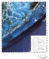 Figure 1. Subscene of Landsat TM image showing details of the Florida Reef Tract, the Florida Keys, and Florida Bay (image 51539-15205, acquired 5/18/88). Map inset shows outline of Judy Creek Field at the same scale of Landsat image.
End_Page 74-------------------------
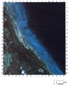 Figure 2. Subscene of Landsat TM image showing a portion of the Andros Barrier Reef on Great Bahama Bank (image 50789-15030, acquired 4/29/86).
End_Page 75-------------------------
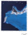 Figure 3. Subscene of Landsat TM image showing varied depositional environments along the northwestern portion of the Caicos Platform, British West Indies (image 52457-14333 acquired 11/22/90).
End_Page 76-------------------------
large islands (E9) where channels and sand bars occur. Onbank and offbank circulation and sediment transport are focused through these larger breaks in the island rim to feed into the somewhat deeper water interior portion of the platform.
CHINCHORRO BANK, MEXICO
Chinchorro Bank (Fig. 4) is one of a series of isolated carbonate platforms formed on block-faulted highs that extend from Belize northward to Cozumel Island. The windward (eastern) side of Chinchorro Bank is characterized by a nearly continuous barrier reef trend with well developed spur and groove structures. In several places, this trend is disrupted by major (up to 1.5 km) slumps where large segments of the reef tract have failed, for example at N7. Behind the reef is a continuous narrow apron of grainstones and patch reefs which abruptly drop off 2 to 3 m into the back reef lagoon. In contrast, the leeward margin of the platform is dominated by small (<0.8 km) patch reefs surrounded by grainstone and rudstone aprons.
The northern portion of the platform interior is composed of a series of elongate, subparallel ridges and lagoons. The most prominent ridge (I11 to L6) contains a trend of patch reefs, sand flats, and a large island, and fronts a large lagoon (H12 to K5). In the southern, deeper portion of the platform, clearly defined linear trends are absent. However, areas of patch reefs and sand flats are present and a NW-SE trend of coalescing patch reefs forms a type of continuous barrier (F14 to H18) 4 to 8 km behind the platform margin.
BELIZE
The barrier reef of Belize is continuous for nearly the full length of the shelf break, extending about 250 km from the Yucatan Peninsula to the Gulf of Honduras. The 20 to 40 km wide shelf lying between the mainland and the barrier reef is highly variable in both water depth and depositional environments from north to south. Toward the south the lagoon, up to 50 m deep, supports a diverse array of reef types (Fig. 5). The barrier reef and lagoon reefs are influenced by the prevailing easterly winds, winter cold fronts from the north, and frequent hurricanes moving generally from east to west. Patch reefs, pinnacle reefs, and rhomboid (atoll-like) shoals in the lagoon vary in relief and areal extent. The rhomboid shoals, I17 for example, are high-relief, irregularly shaped patch reefs in the outer portion of the southern lagoon.
On closer view, the Belize reef rim contains numerous channels and breaks along its trend. Where well developed, the reef contains the full suite of "classic" reef attributes, including spur and groove structures on the seaward side, a broad reef flat, and sand apron immediately leeward. For example, Columbus Reef (K7 to K10) displays a broad reef flat composed of coral rubble transported landward from the reef.
Portions of two offshore isolated platforms are also visible on Figure 5: the southern end of the Turneffe Islands (M2) and Glovers Reef (Q14). Glovers Reef, an oval shaped isolated platform located 15 km east of the barrier reef, contains an almost continuous barrier reef enclosing a shallow lagoon with hundreds of patch reefs.
GREAT BARRIER REEF, AUSTRALIA
The Great Barrier Reef is unparalleled in length as it extends continuously along the northeastern Australian continental shelf for about 2250 km. The northern portion (Fig. 6) shows well the diversity and broad distribution of reefs on a rimmed shelf. The shelf varies in width from 30 to 50 km and is generally less than 40 m deep.
Barrier reefs extend along 70 per cent of the shelf edge, but reefs are also common over a broader area occupying the outer two-thirds of the shelf, and even nearer the coastline where they are associated with small islands. The ribbon-like barrier reefs vary from 3 to 26 km in length and 300 to 450 m in width, and are separated by narrow but deep passages. Reefs from D1 to P20 on Figure 6 have a well-developed reef crest of algae-encrusted pavement and a sand apron with scattered patch reefs extending shelfward. Locally, reef growth extends along the narrow channels as cuspate projections facing shelfward (reefs from B1 to M10). Isolated reefs situated landward of the barrier generally have a windward margin on the southeast side facing into the direction of prevailing winds and a lagoon, sometimes deep, with areas of complex patch reef development. Inner shelf reefs occur locally within several kilometres of the coastline and also fringing high rocky islands such as Lizard Island (D12), a high rocky island formed of Permian granite.
DISCUSSION OF MODERN REEF STYLES
Three generalized styles of reefs are shown by the modern examples: linear reefs rimming the edges of shelves and large platforms, small isolated reefs within either shallow or deep shelves and lagoons; and reefs on isolated carbonate platforms or banks that are separated by deep water. Linear reefs rim the edges of shelves or platforms in South Florida, the Bahamas, Caicos, Belize, and the Great Barrier Reef. These examples provide a good indication of the variable distribution and continuity of reefs along the rim, the typical widths of an active reef belt, and also the range of dimensions for individual reefs within this reef style. South Florida, the Bahamas, and Caicos have shallow shelves or lagoons with smaller isolated reefs, whereas Belize and the Great Barrier Reef contain broad, deep shelves or lagoons with smaller isolated reefs. These areas show the broad spectrum of sizes and shapes typifying individual reefs and variability in the patterns of reef distribution within the lagoon setting. Chinchorro Bank and the offshore Belize platforms are examples of isolated carbonate platforms, or banks that are separated by deep water, and illustrate the aerial extent of such buildups, the distribution of individual reefs within an isolated platform, and overall facies variability across the platform top.
In his comparison of Devonian and modern reefs, Klovan (1974) considered Devonian reef tracts and individual reefs to be of three morphological types: linear tracts to which he compared the reef-tract geometry of the northern Great Barrier Reef and the Campeche Shelf offshore of Yucatan; broad reef tracts compared with the distribution of patch reefs behind the
End_Page 77-------------------------
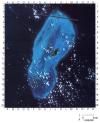 Figure 4. Subscene of Landsat TM image showing Chinchorro Bank, an isolated platform offshore of Mexico (image 42130-15375, acquired 5/9/88). The dark, heavy line from F3 to N4 is a data dropout, an artifact of the image. White areas are clouds.
End_Page 78-------------------------
main barrier reef in the northern Great Barrier Reef, and also in Belize; and isolated platform reefs with no direct comparison to modern examples.
The modern examples illustrated and discussed herein depict many of the geological characteristics that can be expected in ancient reef settings:
(1) The reefs may occur as part of the rims on attached shelves (South Florida, the Bahamas, Caicos, Belize, and the Great Barrier Reef are examples) or on isolated platforms (Chinchorro Bank and the offshore Belize platforms are examples):
(2) The variation in continuity along a linear reef trend and width of an active reef belt are shown by all of the examples:
(3) The inner portions of these reefal settings are quite variable, having smaller isolated reefs in shallow shelves and lagoons (South Florida, the Bahamas, and Caicos are examples) or in broad, deep shelves and lagoons (Belize and the Great Barrier Reef are examples); and
(4) The individual reefs within all of these larger scale situations are highly variable in size and orientation (particularly shown in Caicos, Chinchorro Bank, Belize, and the Great Barrier Reef).
The geological framework as illustrated by these modern areas can be important in the development-scale analysis of ancient reservoirs where: (a) the lateral variation of porosity and permeability, i.e. reservoir quality, is commonly tied to facies changes; (b) reservoir quality is controlled by aspects of diagenesis that are directly linked to facies variation: and (c) facies dimensions are required as input to reservoir models. The geological framework as shown by the modern areas is also important at the exploration scale for reservoir facies prediction and stratigraphic play concepts which are related directly to depositional facies patterns.
Although other areas should also be considered as analogues in selected cases. those discussed in this paper cover a
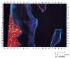 Figure 5. SPOT HRV image showing the southern portion of the Belize reef tract and portions of two offshore platforms (image 16123169002101645302x, acquired 2/10/90). (SPOT Image Data Copyright CNES, 1994, provided by SPOT Image Corp.).
End_Page 79-------------------------
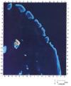 Figure 6. Subscene of Landsat TM image showing a portion of the trend of shelf-edge ribbon reefs from the northern Great Barrier Reef, Australia (image 52026-234651, acquired 9/17/89).
End_Page 80-------------------------
wide range of reef types and show the many ways that they can be linked within an area. These examples should be examined in more detail in Harris and Kowalik (1994), and the many references cited therein, to give indications of likely lateral facies relationships and better provide ranges of facies dimensions.
Pay-Per-View Purchase Options
The article is available through a document delivery service. Explain these Purchase Options.
| Watermarked PDF Document: $14 | |
| Open PDF Document: $24 |