The AAPG/Datapages Combined Publications Database
Environmental Geosciences (DEG)
Figure
Environmental Geosciences (DEG); Year: 2020; Issue: March DOI: 10.1306/eg.09261919016
Return to Full Text
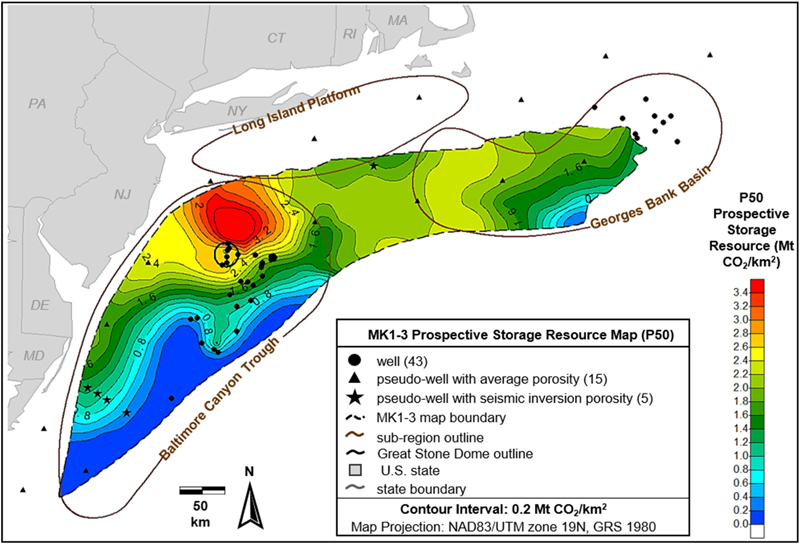
Figure 13. Map showing the well locations, three subregions, and Great Stone Dome outline alongside prospective storage resource estimates in megatonnes of CO2 per square kilometer for middle Cretaceous 1–3 (MK1-3) zone. CT = Connecticut; DE = Delaware; GRS = geodetic reference system; MA = Massachusetts; MD = Maryland; NAD83/UTM zone 19N = North American Datum 1983 Universal Transverse Mercator, zone 19 (northern hemisphere); NJ = New Jersey; NY = New York; P50 = 50th percentile; PA = Pennsylvania; RI = Rhode Island.
Figure 13. Map showing the well locations, three subregions, and Great Stone Dome outline alongside prospective storage resource estimates in megatonnes of CO2 per square kilometer for middle Cretaceous 1–3 (MK1-3) zone. CT = Connecticut; DE = Delaware; GRS = geodetic reference system; MA = Massachusetts; MD = Maryland; NAD83/UTM zone 19N = North American Datum 1983 Universal Transverse Mercator, zone 19 (northern hemisphere); NJ = New Jersey; NY = New York; P50 = 50th percentile; PA = Pennsylvania; RI = Rhode Island.