About This Item
- Full TextFull Text(subscription required)
- Pay-Per-View PurchasePay-Per-View
Purchase Options Explain
Share This Item
The AAPG/Datapages Combined Publications Database
GCAGS Transactions
Abstract
Tertiary-Cretaceous Growth of the East Texas Basin
Lester A. Coon (1)
ABSTRACT
The East Texas Basin (Plate 1), as used in this presentation, is that portion of East Texas bounded on the west and north by the Woodbine, basal Upper Cretaceous, outcrop, and on the east by the Sabine Uplift, which crests near the Texas-Louisiana line. Geographically, the west edge falls in Hill, Tarrant, and Denton Counties, and the north edge coincides with the Red River. The south edge is postulated to be near the Jackson (Fayette)-Yegua outcrop in Madison and Trinity Counties. The axis of the basin extends northward from Houston County through Anderson and Smith Counties to Wood County, then curves sharply eastward through Camp to Cass County. The deepest part of the East Texas Basin. centering near the Hainesville Dome in Wood County, is commonly referred to as the Mineola Basin.
The maximum thickness of Tertiary and Cretaceous sediments the deepest part of the basin has never been drilled, but it is reasonable to suspect that it probably exceeds 15,000 . Slightly over 11,000 of this total are Cretaceous sediments containing numerous prospective horizons. These horizons have yielded approximately 4,420,270,165 barrels of oil as of January 1, 1956, making the East Texas Basin one of the most richly productive of the sedimentary basins on this continent
Plate 1. Structure map of Northeast Texas on base of Massive Anhydrite.
End_Page 85-------------------------
to date. There has been no Tertiary production to date in the East Texas Basin worthy of mention although the extreme south edge of the basin is very probably prospective.
The East Texas Basin is at least as old as the Jurassic and was a well developed basin by the beginning of Lower Cretaceous deposition. Growth of the basin continued slowly from semi-continental type sands and red beds of the Travis Peak, through the marine Glen Rose section followed by sand and shale of the Paluxy with no major unconformity. The slow growth of the basin during the marine sedimentation of the Glen Rose probably caused the elongate narrow bands of porosity in the Pettet, such as the South Hallsville field and similar ones on the flanks of the Waskom field structure. They appear to be characteristic of onlap or offshore bar type deposits in shallow water paralleling relatively positive areas. The Washita-Fredericksburg seas overlapped the Trinity with a rhythmic series of limestones and shores. The first really major unconformity resulted in the uplifting and erosion of the Sabine Uplift. At least 3,000 of Lower Cretaceous sediments were truncated from the crest of the Sabine Uplift.
Deposition of the Upper Cretaceous began with massive sands of the Woodbine followed by the predominantly shale section of the Eagle Ford. At the close of Eagle Ford time, another significant unconformity occurred resulting in the truncation of the Eagle Ford and Woodbine on the Sabine Uplift. Both formations were then progressively overlapped by the impervious Austin Chalk resulting in the ideal conditions to form the East Texas field. The presence of a coarse conglomerate
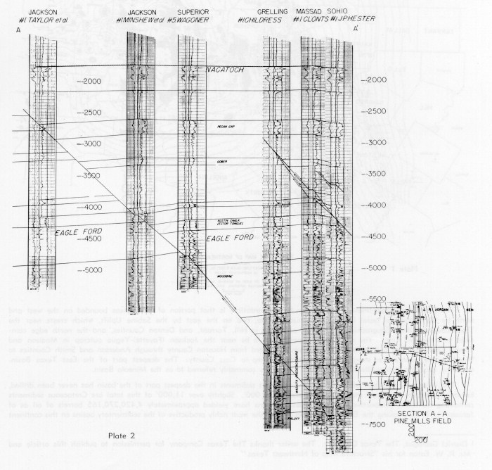 PLATE 2. [Grey Scale] Cross section A-A, Pine Mills field.
End_Page 86-------------------------
on the extreme east edge of the East Texas field suggests that the conglomerate is Lower Woodbine and that the Woodbine was never deposited much farther east than its present position. The absence of a conglomerate in the Upper Woodbine elsewhere in the basin indicates that the conglomerate in the East Texas field is Lower Woodbine and that the Lower Woodbine was not overlapped by the Upper Woodbine on the west flank of the Sabine Uplift.
The beginning of Upper Cretaceous deposition coincided with a rejuvenation of the East Texas Basin in the form of continuous downwarping with spasmodic periods of more rapid growth. It appears that these latter stages of rapid growth coincided largely with Eagle Ford and Taylor time. These periods resulted in structural phenomena which are peculiar to the Mineola Basin, the deepest part of the East Texas Basin. The phenomena are:
- Practically all regional strike faults are upthrown to the basin.
- The order of throw of faults, with the maximum displacement in the Upper Cretaceous, decreases rapidly in younger and older sediments. For example, the Pine Mills field fault has a throw of approximately 250 at or near the base of Austin Chalk, but does not appear to be expressed at Paluxy level as shown on Plate 2.
The end of Upper Cretaceous deposition was marked by a period of truncation at the outcrop, but the basin as a whole was quickly submerged by Midway seas. Consequently, the truncation of the Upper Cretaceous beds was probably not as severe as the erosion of the surface of the Lower Cretaceous. The greater truncation of the Lower Cretaceous was due to the broad regional effects of the Sabine Uplift at the end of Lower Cretaceous deposition.
Progressive downwarping of the East Texas Basin continued during Midway and Wilcox time with predominantly marine sedimentation. Wilcox sedimentation suggests a shallow water, lagoonal type environment in that lignite, pyrite, and glauconite are generously interspersed with sands and grey shales. Surface and subsurface evidence suggests another short period of rapid downwarping during Claiborne time. The Sabine Uplift had its third great period of uplift at the close of Claiborne deposition when all of the Claiborne and a substantial part of the Wilcox was eroded from the uplift.
Section A-A (Plate 3) is drawn to a vertical scale of 1 = 400 and a horizontal scale of 1 = 3 miles. Unfortunately, this degree of vertical exaggeration gives an erroneous impression of dip and thicknesses; however, the limitations of slide projection made it necessary. The rate of dip on the top of the Lower Glen Rose, Rodessa formation, is very much greater than it is on top of the Upper Cretaceous which reflects the rapid downwarping of the basin during Upper Cretaceous deposition.
 PLATE 3. [Grey Scale] Cross section from Sabine uplift through Tyler basin.
End_Page 87-------------------------
The major features reflected on the section are:
- The truncation of the Washita-Fredericksburg section at the east side of the section.
- The Willow Springs anticline at wells numbered 6 and 7.
- The truncation of the Eagle Ford and Woodbine sections which are overlapped by the Austin Chalk forming the stratigraphic trap of the East Texas field. Incidentally, the east edge of the Eagle Ford approximately coincides with the original west edge of the East Texas field. The field has produced 3,159,807,267 barrels of oil as of January 1, 1956.
- The Red Springs -- Sand Flat dome at well #11. A curious feature of this structure is that there are approximately 350 of closure on top of the Woodbine, yet there is no Woodbine production anywhere on the structure, in spite of the fact that isopachous thinning is indicated all through the Upper Cretaceous. As a matter of fact, none of the major structures in Smith County have Woodbine production.
- The Lindale -- Bud Lee anticline at well #12. This regional feature is about twelve miles long and has scattered gas production from the Rodessa and oil from the Paluxy.
- The Van structure, at well #13, has about 1,500 of closure at Woodbine level and is the most prominent producing structure in the East Texas Basin.
The north - south section (Plate 4), Red River County to Smith County, shows the relationship of the Cretaceous to the older Jurassic beds and Paleozoic floor. The progressive overlap of the younger Trinity beds is shown as well as the overlap of the Jurassic in Lamar County.
 PLATE 4. [Grey Scale] Cross section from Red River County to Smith County.
End_Page 88-------------------------
The actual updip limit of the salt cannot be measured accurately, nor is its relationship to the Talco Graben known although it is believed that the faulting does extend to the Paleozoic floor and is part of rejuvenated Paleozoic faulting.
The magnitude of the unconformity at the end of Upper Cretaceous deposition is indicated to be much greater on the north - south section than it is on the east - west section. The Sabine Uplift was located too far out into the Navarro basin to have been affected by the unconformity.
A fault is shown in the Buckner in well #6, the Humble #3 Yantis Gas Unit, Yantis field, Wood County, Texas. This fault is postulated and cannot be proved at this time, but the well did not encounter Smackover before penetrating salt. The absence of the Smackover has been the rule rather than the exception in recent deep Smackover drilling in Rains and Wood Counties, suggesting that regional faulting of Jurassic age may be present which is not expressed in younger beds due to Jurassic erosion.
The absence of the Smackover in the Shell - Goldsmith test in the Quitman field, well #7 on the section, is attributed to pinchout and/or erosion rather than faulting due to the fact that the Quitman field structure is a deep seated salt dome of some magnitude, and it is reasonable to believe that the salt penetrates some of the overlying sediments similar to a shallow piercement type salt dome.
The Upper Cretaceous age of the Mineola Basin is well illustrated by the extremely rapid rate of thickening of the Upper Cretaceous formations in the Jackson et al #1 Wisenbacker in Wood County, well #8 on the section. The Taylor, Eagle Ford, and Woodbine growth of the Mineola Basin is particularly well illustrated and indicates the age of much of the faulting in Wood County. It may also account for the rather rapid decline in throw of some of the faults in younger and older beds.
 PLATE 5. [Grey Scale] Cross section from Smith County to Madison County.
End_Page 89-------------------------
The thinning of the Upper Cretaceous and the Washita-Fredericksburg intervals at the south end of the north - south (Smith County to Madison County, Plate 5) cross section is considered to be particularly significant in that it indicates the presence of a south rim and that the East Texas Basin was a closed basin during Upper Cretaceous deposition. This south rim was in the form of a narrow regional shelf with resultant isopachous thinning and deposition peculiar to the shelf area. There are unconformities present which correlate with similar ones on the Sabine Uplift suggesting that the shelf may have been a spur of the Sabine Uplift. Other evidence suggesting the presence of the south rim are:
- Massive porous limestone in the Rodessa section in southernmost Houston and Trinity Counties.
- Truncation of the Kiamichi, Maness shale, and Eagle Ford shale from wells in Trinity County. Limitations of the vertical scale do not permit showing the correlations indicating the postulated truncations.
- Lastly, and this is thought to be conclusive, the absence of sand in the Woodbine west and south of a line extending from southern Trinity through Madisonville in Madison County to Flynn in Leon County, then to the Woodbine outcrop in northern McLennan County, where the Woodbine is overlapped by the Eagle Ford, indicates that a relatively positive area of non-deposition existed during Woodbine time. Subsequent southward tilting of the basin in the downwarping of the Gulf Coastal Plain has obscured the shelf.
The East Texas Basin has been the most profitable producing area developed in the United States to date considering the relatively small geographical size of the area, depths to principal objective horizons, and established reserves. The wealth of Cretaceous subsurface control appears to indicate that most of the major large structural features have been found and mapped, but pre-Cretaceous exploration of the features has only been started and results have been encouraging considering the large size of the features and the limited number of deep tests on most of them. Stratigraphic traps, with significant reserves in the Cretaceous, will be found on the flanks of the large structural features. The recent discovery of oil in the Woodbine on the Hainesville Dome in Wood County and the Bethel Dome in Anderson County proves that the interior shallow piercement type domes of the East Texas Basin are highly prospective, and they will probably be focal points of exploratory interest in the future.
End_of_Record - Last_Page 90--------
Pay-Per-View Purchase Options
The article is available through a document delivery service. Explain these Purchase Options.
| Watermarked PDF Document: $14 | |
| Open PDF Document: $24 |