About This Item
- Full text of this item is not available.
- Abstract PDFAbstract PDF(no subscription required)
Share This Item
The AAPG/Datapages Combined Publications Database
GCAGS Transactions
Abstract
Abstract: Fault  Map
Map of South Louisiana
W. E. Wallace (1)
The ![]() map
map![]() which accompanies this publication is the current version of a series which commenced in 1943. At that time, the writer was completing a dissertation entitled, "A Study of Deep-Seated Domes of South Louisiana." The dominant faulting of about thirty oil and gas fields was drafted on a
which accompanies this publication is the current version of a series which commenced in 1943. At that time, the writer was completing a dissertation entitled, "A Study of Deep-Seated Domes of South Louisiana." The dominant faulting of about thirty oil and gas fields was drafted on a ![]() base
base![]()
![]() map
map![]() for study. The various orientations presented no readily understandable pattern at that time. This
for study. The various orientations presented no readily understandable pattern at that time. This ![]() map
map![]() contained original work on the following fields:
contained original work on the following fields:
- Abbeville
- Barataria
- Bayou Sale-Horseshoe Bayou
- Bateman Lake
- Bosco
- Erath
- Gibson
- Gillis-English Bayou
- Grand Bay
- Iowa
- LaFitte
- Lake Long
- North Crowley
- Paradis
- Quarantine Bay
- Raceland
- Roanoke
- Sweet Lake
- Tepetate
- West Gueydan
- Woodlawn
Much of this dissertation appeared in a paper in the Bulletin of the A.A.P.G. of September, 1944.
In 1949, the author assembled another such ![]() map
map![]() with the help of F. B. Stein, Lloyd Traupe, and many others. This was presented at the geological meeting in Biloxi, Mississippi, in October, 1949. The paper was entitled "Deep-Seated Domes of South Louisiana, a Regional Interpretation" and included field structure maps of the following:
with the help of F. B. Stein, Lloyd Traupe, and many others. This was presented at the geological meeting in Biloxi, Mississippi, in October, 1949. The paper was entitled "Deep-Seated Domes of South Louisiana, a Regional Interpretation" and included field structure maps of the following:
- Arnaudville
- Bon Air
- Iota
- Raceland
- South Jennings
- South Roanoke (now Lake Arthur)
This paper was never available in published form.
At the Corpus Christi regional meeting of November, 1952, a third ![]() map
map![]() was presented. This was published in its original size in the transactions together with a brief comment on faulting. On this
was presented. This was published in its original size in the transactions together with a brief comment on faulting. On this ![]() map
map![]() , an attempt was made to show hypothetical rim synclines around all of the piercement domes. More information on these has become available indicating great variations in the position of the synclines relative to the salt stock. In the 1957
, an attempt was made to show hypothetical rim synclines around all of the piercement domes. More information on these has become available indicating great variations in the position of the synclines relative to the salt stock. In the 1957 ![]() map
map![]() , these have been omitted.
, these have been omitted.
Again the author wishes to present a fault ![]() map
map![]() for a better overall view of the fault patterns. Friends and members of the staff have been asked to supply a large part of the data. As usual, it has been necessary to compromise on the data left on the
for a better overall view of the fault patterns. Friends and members of the staff have been asked to supply a large part of the data. As usual, it has been necessary to compromise on the data left on the ![]() base
base![]()
![]() map
map![]() . Pipelines, towns, parish names, and many other details have been omitted. The
. Pipelines, towns, parish names, and many other details have been omitted. The ![]() base
base![]() was taken from the Oil and Gas
was taken from the Oil and Gas ![]() Map
Map![]() of Louisiana published by the Louisiana Geological Survey in Baton Rouge, Louisiana, (Feb, 1956). Those who wish the oil and gas fields in color should obtain a copy from the Survey.
of Louisiana published by the Louisiana Geological Survey in Baton Rouge, Louisiana, (Feb, 1956). Those who wish the oil and gas fields in color should obtain a copy from the Survey.
The new ![]() map
map![]() only points up the complexity of faulting and the number of larger and smaller trends. No new theory is offered.
only points up the complexity of faulting and the number of larger and smaller trends. No new theory is offered.
REFERENCES
Wallace, William E., "A Study of Deep-Seated Domes of South Louisiana." Ph. D. Dissertation, La. State University, 1943.
Wallace, William E., "Structure of South Louisiana Deep-Seated Domes," Bull. Amer. Assoc. Petrol. Geol., vol. 28, no. 9, (September, 1944, pp. 1259-1312).
Wallace, William E., "Deep-Seated Domes of South Louisiana, A Regional Interpretation," unpublished manuscript, Gulf Coast Geological Meeting, October, 1949. Wallace, William E., "South Louisiana Fault Trends," Trans. Gulf Coast Assoc. Geol. Soc., 2nd Ann., (November, 1952)., pp. 63-66, and ![]() map
map![]() .
.
Publications of the Amer. Assoc. Petrol. Geol.
Publications of the Louisiana Geological Survey.
Publications of the Soc. of Explor. Geophys.
Publications of the Gulf Coast Assoc. of Geol. Soc.
Testimony and Exhibits before the Department of Conservation, State of Louisiana.
Unpublished fault data supplied by numerous associates in South Louisiana.
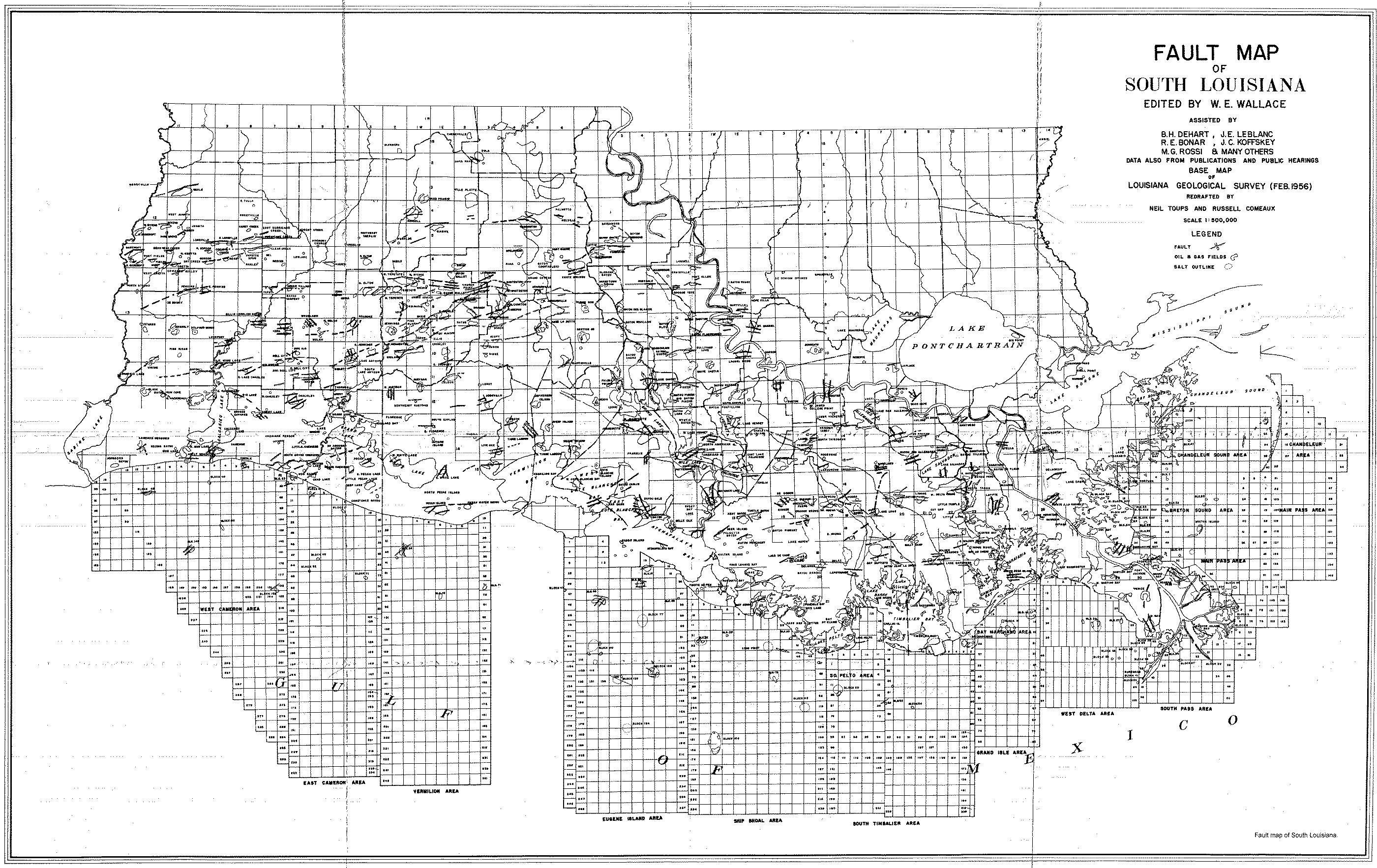 FIGURE 1. [Grey Scale] (unnumbered) Fault
 ![]() map
map![]() of South Louisiana.
of South Louisiana.
End_of_Record - Last_Page 240-------
ACKNOWLEDGMENTS AND ASSOCIATED FOOTNOTES
(1) Forest Oil Corporation, Lafayette, Louisiana
Editor
Copyright © 1999 by The Gulf Coast Association of Geological Societies