About This Item
- Full text of this item is not available.
- Abstract PDFAbstract PDF(no subscription required)
Share This Item
The AAPG/Datapages Combined Publications Database
GCAGS Transactions
Abstract
Abstract: Faults of South and Central Texas
Delos R. Tucker
ABSTRACT
The map entitled "Faults of South and Central Texas" (accompanying this paper) shows the location, depth of trace, and approximate vertical displacement of the various normal faults located in the area covered by the investigation. The information on the faults was derived from: published sources (listed below) ; various individuals including especially, William Pittman, Wilford Stapp, and Porter Montgomery; and studies in company files.
The writer found that most reports on a given area were broadly about the same, but might differ considerably in detail. Certainly, no two maps were identical; each geologist seems to have his particular style of fault interpretation. Additional faults will undoubtedly be discovered in the future and the interpretations presented will require alteration.
Most of the faults in the region fall within the major fault systems. A few of the faults occur over structures of "punch-type" origin such as salt domes and igneous masses; radial fault patterns and grabens are commonly associated with these structures (for example, see northern McMullen Co.). A number of faults are associated with folds such as the Pearsall and Chittim anticlines. Finally, there are many faults which appear to be structurally independent and which lie outside the fault systems.
The largest known fault displacement in the region is less than 1000 feet; most displacements do not exceed 200 feet. The total displacement of the down-to-the-coast faults is usually about the same as the total displacement of the opposing nearby up-to-the-coast faults. The individual faults and fault systems generally have strikes which are within 10 to 20 degrees of the strikes of the beds in which they occur. Surface and subsurface studies both show that the ends of controlled faults often turn in downdip direction.
The actual movements on the faults constituting the major fault systems appear to have occurred only in the downthrown blocks; these blocks are almost invariably lower than persistent regional stratigraphic surfaces. The upthrown blocks are usually even with these surfaces.
REFERENCES
Alexander, W. H., Myers, B. N. and Dale, O. C., 1964, Reconnaissance Investigation of the Ground-Water Resources of The Guadalupe, San Antonio and Nueces River Basins, Texas: Texas Water Commission Bull. 6409.
Anders, R. B., 1957, Ground-Water Geology of Wilson County, Texas; Texas Board Water Engineers Bull. 5710.
Anders, R. B., 1960, Ground-Water Geology of Karnes County, Texas: Texas Board Water Engineers Bull. 6007.
Bailey, T. L., 1926, The Gueydan, A New Middle Tertiary Formation From The Southwestern Coastal Plain of Texas: Univ. of Texas Bull. 2645.
Bennett, R. R. and Sayre, A. N., 1962, Geology and Ground-Water Resources of Kinney County, Texas: Texas Water Commission Bull. 6216.
Bills, T. V., Jr., 1957, Geology of Waco Springs Quadrangle, Comal County, Texas (unpub. Univ. Texas thesis).
Bolinger, J. W., 1953, History of the Imogene Oil Field, Atascosa Co., Texas: Trans. Gulf Coast Assoc. Geol. Soc., v. 3, pp. 13-30.
Brucks, E. W., 1925, Luling Field, Caldwell and Guadalupe Counties: Bull. Amer. Assoc. Petrol. Geol., v. 9, pp. 632-654.
Brucks, E. W., 1927, Geology of The San Marcos Quadrangle: Bull. Amer. Assoc. of Petrol. Geol., v. 11, pp. 825-851.
Callendar, D. L., 1958, Petrology of the Queen City Formation, Bastrop County, Texas. (unpub. Univ. Texas thesis).
Collingwood, D. M., Row, C. H. and Weeks, H. J., 1926, Lytton Springs Oil Field, Caldwell, County: Bull. Amer. Assoc. Petrol. Geol., v. 10, pp. 953-975.
Cook, C. E., 1932, Areal Geology of The Catahoula Formation in Gonzales and Karnes Counties, Texas (unpub. Univ. Texas thesis).
DeCook, K. J., 1957, Geology of The San Marcos Springs Quadrangle, Hays County, Texas (unpub. Univ. Texas thesis).
Deussen, A. and Dole, R. B., 1916, Ground Water in LaSalle and McMullen Counties: U. S. Geol. Sur. Water-Supply Paper 375, pp. 141-177.
Eargle, D. H. and Anders, R. B., 1957, A. Preliminary Report on the Stratigraphy of the Uranium-bearing of the Karnes County Area, south-central Texas: Univ. Tex. Bur. Econ. Geol. Rept. Inv. 30.
Ferguson, W. K. L., 1958, Geology of Parts of Bastrop and Fayette Counties, Texas (unpub. Univ. of Texas thesis).
Foust, R. T. Jr. and Reagan, M. A., 1960, Discovery and Development of the Person Field, Karnes Co., Texas: Trans. Gulf Coast Assoc. Geol. Soc., v. 10, pp. 25-31.
Fowler, Phillip, 1956, Faults and Folds of South-Central Texas: Trans. Gulf Coast Assoc. Geo. Soc., v. 6, pp. 37-42.
George, W. O., 1952, Geology and Ground-Water Resources of Comal County, Texas: U. S. Geol. Sur. Water-Supply Paper 1138.
End_Page 144------------------------
Giannone, R. J., 1951, Geology of Caldwell Knob Area, Bastrop County, Texas (unpub. Univ. Texas thesis).
Hargis, Richard N., 1962, Stratigraphy of Carrizo-Wilcox of a Portion of S. Tex. and its Relationship to Production: Trans. Gulf Coast Assoc. Geol. Soc., v. 12, pp. 9-25.
Holt, C. L. R. Jr., 1956, Geology and Ground-Water Resources of Medina County, Texas: Texas Board of Water Engineers Bull. 5601.
Hendy, W. C., 1957, Lower Cretaceous (Edwards) Oil Fields, Caldwell and Guadalupe Counties, Texas: Trans. Gulf Coast Assoc. Geol. Soc., v. 7, pp. 23-34.
Jones, F. C. and Knebel, R. M., 1957, Edwards Limestone Fields of Atascosa Co., Texas: Trans. Gulf Coast Assoc. Geol. Soc., v. 7, pp. 35-44.
Keahey, R., 1962, Fashing Field, Atascoasa-Karnes, Tex: Trans. Gulf Coast Assoc. Geol. Soc., v. 12, pp. 205-211.
Kimmell, C. E., 1957, Edwards Limestone Exploration in Webb, LaSalle, McMullen and Live Oak Counties, Tex: Trans. Gulf Coast Assoc. Geol. Soc., v. 7, pp. 45-49.
King, E. A., 1961, Geology of Northwestern Gonzales County, Texas (unpub. Univ. Texas thesis).
King, V. L., 1957, Geology of the Mission Valley Quadrangle, Comal County, Texas (unpub. Univ. of Texas thesis).
Knapp, R. W., 1962, Person Field, Trans. Gulf Coast Assoc. Geol. Soc. v. 12, pp. 199-204.
Lang, C. D., 1962, Big John (Edwards) Field: Trans. Gulf Coast Assoc. Geol. Soc., v. 12, pp. 195-198.
Lee, F. and Welder, F., 1961, Southern Edwards Plateau: 1961 Field Trip Guidebook, Gulf Coast Assoc. Geol. Soc. pub.
Lonsdale, J. T., Halbouty, M. T., and Sayre, A. N., 1935, Geology and Ground-Water Resources of Atascosa and Frio Counties: U. S. Geol. Sur. Water-Supply Paper 676.
Lonsdale J. T., and Day, J. R., 1937, Geology and Ground-Water Resources of Webb County: U. S. Geol. Sur. Water-Supply Paper 778.
Noyes, A. P., Jr., 1957, Geology of Purgatory Creek Area, Hays and Comal Counties, Texas (unpub. Univ. of Texas thesis).
Palmer, L. L., 1954, Structural Significance of the Floresville-Stockdale Trend: Trans. Gulf Coast Assoc. Geol. Soc., v. 4, pp. 19-24.
Palmer, L. L., 1963, Floresville-Stockdale Trend: Bull. S. Tex. Geol. Soc. December Issue.
Pinkley, G. R., 1958, Eocene-Miocene Oil-Uranium: S. Tex. Geol. Soc. Fall Field Trip (guidebook).
Plummer, R. S., Jr., 1949, The Geology of West-Central Bastrop County, Texas (unpub. Univ. of Texas thesis).
Rasmussen, W. C., 1947, Geology and Ground-Water Resources of Caldwell County: Texas Board Water Engineers.
Renick, B. C., 1936, Jackson group and the Catahoula and Oakville formations in the Texas Gulf Coastal Plain: Univ. Tex. Bull 3619.
Ridley, W. C., 1955, Geology of the Northwest Corner of the Smithville Quadrangle, Bastrop County, Texas (unpub. Univ. of Texas thesis).
Ripple, A. L., 1951, Geology of the Muldoon Area, Fayette County, Texas (unpub. Univ. of Texas thesis).
Ryman, L. J., 1954, Southwest Muldoon Field, Fayette County, Texas: Trans. Gulf Coast Assoc. Geol. Soc., v. 4, pp. 27-37.
Sandifer, D. F., 1935, The Balcones Fault Zone North of Manchaca, Texas (unpub. Univ. of Texas thesis).
Sayre, A. N., 1936, Geology and Ground-Water Resources of Uvalde and Medina Counties: U. S. Geol. Sur. Water-Supply Paper 678.
Sayre, A. N. and Turner, S. F., 1960, Geology and Ground-Water Resources of Dimmit County, Texas: Texas Board of Water Engineers Bull. 6003.
Tucker, Delos R., 1962, Central Texas Lower Cretaceous Stratigraphy: Trans. Gulf Coast Assoc. Geol. Soc., v. 12, pp. 89-96.
Tucker, Delos R., 1965, Lower Cretaceous Geology, Northwestern Karnes County, Texas: Bull S. Texas Geo. Soc., Dec. Issue.
Ward, W. C., 1957, Geology of the Barton Creek Area, Bastrop and Fayette Counties, Texas (unpub. Univ. of Texas thesis).
End_Page 145------------------------
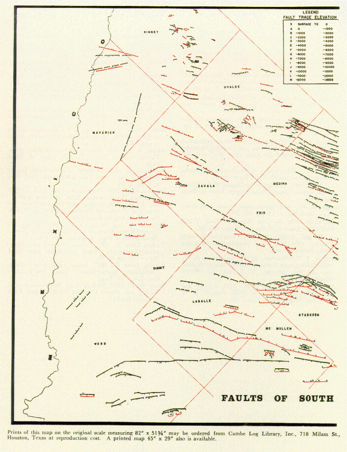 FIGURE 1. [Grey Scale] (unnumbered) Map of faults of South & Central Texas.
End_Page 146------------------------
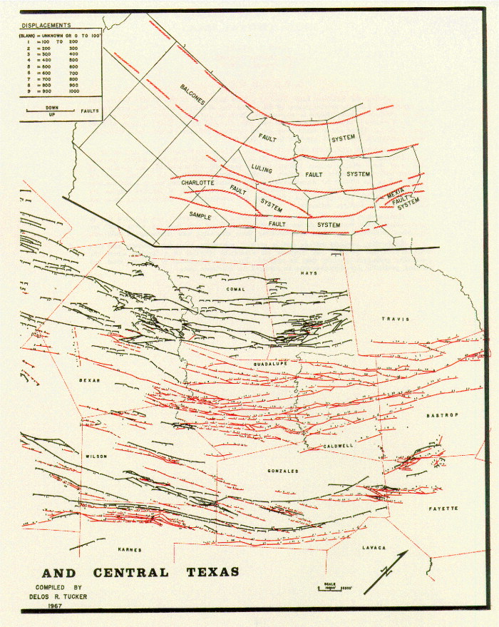 FIGURE 1. [Grey Scale] (unnumbered) (continued) Map of faults of South & Central Texas.
End_of_Record - Last_Page 147-------
ACKNOWLEDGMENTS AND ASSOCIATED FOOTNOTES
5630 Ocean View La Canada, California
Copyright © 1999 by The Gulf Coast Association of Geological Societies