About This Item
- Full text of this item is not available.
- Abstract PDFAbstract PDF(no subscription required)
Share This Item
The AAPG/Datapages Combined Publications Database
GCAGS Transactions
Abstract
Abstract: Preferential Sites of Offshelf Sediment Transport Around a Trade Wind Island: St. Croix (U.S.V.I.)
H. H. Roberts (1), J. M. Coleman (1), C. W. Holmes (2), D. K. Hubbard (3)
ABSTRACT
Theoretical models of flow around islands, plus field data from the Caribbean islands of Grand Cayman, Barbados and, most recently, St. Croix (Fig. 1), suggest the existence of predictable zones of high current speeds at the downdrift extremities of trade wind islands. These high-energy sites correspond to areas of vigorous offshelf sediment transport. High-resolution seismic and side-scan sonar data from St. Croix indicate that the southwest flank of this island is a staging area for sediment transport to deep environments. A blanket of sand-rich Holocene sediment 5 to 10 m thick is present over much of this shelf sector. Discrete sand bodies (up to 15 m) at the shelf margin (Fig. 2) and on the steep island slopes (Fig. 3) cover complex underlying topography, which appears to be related to Holocene reef growth. These wedges of sediment, composed of shallow-water skeletal debris, identify important pathways for offshelf sediment transport.
Contrary to the traditional view, shelf-to-basin transport on the downdrift southwest flank of St. Croix does not appear to be primarily storm related. Acceleration of flow and resulting sediment transport capacity arises from two separate mechanisms. Firstly, the abrupt curvature of the coast at the southwest corner induces a current jet or rip typically observed around headlands or other sharp turns in the coast. Secondly, the complex deformation of the tidal wave as it rounds the island interferes with and reinforces the current jet at Southwest Point. Current meter records and drogue tracks indicate nominal speeds of 50 cm/sec, with velocities commonly occurring in excess of 100 cm/sec. Although the primary current direction is to the west, modulation of the tide produces a second distinct current pulse to the south. Bottom shear stresses produced by these two currents are sufficient to routinely move large volumes of sand-sized sediment over the shelf edge in these two quadrants. Migratory bedforms, as determined by side-scan sonar, confirm these two sediment pathways. High-resolution seismic data provides additional evidence of sediment accumulation on the offshelf slopes. These interactions promote significant offshelf sediment movement at preferred sites and in preferential directions. Models for the progradation of shelf margins and adjacent slopes in carbonate systems must incorporate these concepts of sediment transport.
End_Page 440------------------------
Figure 1. Location map of the St. Croix (U. S. Virgin Islands) study showing the area of strong offshelf transport and seismic lines.
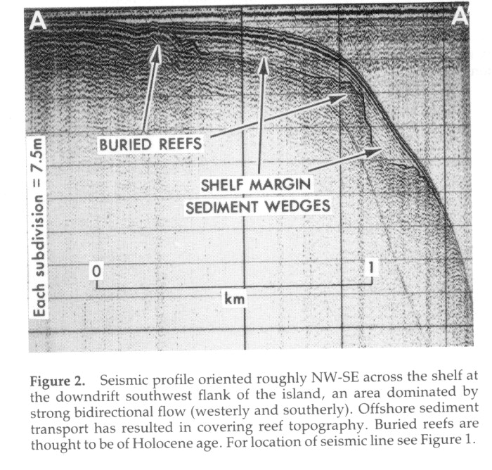 FIGURE 2. [Grey Scale] Seismic profile oriented roughly NW-SE across the shelf at the downdrift southwest flank of the island, an area dominated by strong bidirectional flow (westerly and southerly). Offshore sediment transport has resulted in covering reef topography. Buried reefs are thought to be of Holocene age. For location of seismic line see Figure 1.
 FIGURE 3. [Grey Scale] Seismic profile oriented roughly E-W across a well-developed shelf margin reef and reentrant into the shelf. Unconsolidated Holocene sediment wedges are present behind the shelf margin reef and on the island slope. For location of seismic line, see Figure 1.
End_of_Record - Last_Page 441-------
ACKNOWLEDGMENTS AND ASSOCIATED FOOTNOTES
(1) Coastal Studies Institute, Louisiana State University, Baton Rouge, Louisiana 70803
(2) United States Geological Survey, Marine Geology Branch, Corpus Christi, Texas 78411
(3) West Indies Laboratory, Fairleigh Dickinson University, Christiansted, St. Croix, U. S. Virgin Islands
This research was part of a project entitled "Physical Dynamics and Sediment Transport," which was conducted from the Fairleigh Dickinson West Indies Laboratory on St. Croix, U. S. Virgin Islands. The work was funded by the Naval Experimental Prediction Research Facility under Program Element 62759N, Project 9F52551792, "Atmospheric Environmental Support," through ONR Contract N000014-75-C-0192.
Copyright © 1999 by The Gulf Coast Association of Geological Societies