About This Item
- Full text of this item is not available.
- Abstract PDFAbstract PDF(no subscription required)
Share This Item
The AAPG/Datapages Combined Publications Database
GCAGS Transactions
Abstract
ABSTRACT: Geologic Framework of the Northern Edwards Aquifer, Central Texas
ABSTRACT
The northern segment of the Edwards aquifer comprises Lower Cretaceous Comanche Peak, Edwards, and Georgetown strata of central Travis, Williamson, and southern Bell Counties, Texas (Fig. 1). Geologic and structural-contour maps and cross sections were constructed to illustrate geologic elements, including the aquifer outcrop belt/recharge area, faults, aquifer stratigraphy, and aquifer-thickness variations. These geologic interpretations support applications such as (a) identifying aquifer recharge boundaries, (b) recognizing attributes and variations within aquifer strata, (c) making water-management decisions related to groundwater flow and aquifer response for pumpage and recharge, and (d) providing information necessary for land-use planning and permitting construction projects. This study entailed a review and compilation of existing data and interpretations by the authors and by previous workers and new efforts at constructing cross sections and maps. Geologic aspects important to the aquifer's framework that are discussed herein include (a) variations in the thickness of the aquifer strata, (b) lateral lithostratigraphic changes, and (c) location and displacements of faults.
Across the study area, normal faults of the Balcones Fault Zone displace Cretaceous limestone, dolomite, marl, and shale that represent >2,000 ft of shelf and shelf-margin deposition. Composing a commonly prolific part of the aquifer, Edwards limestone, dolomitic limestone, and dolomite are often more porous than the other aquifer strata, Georgetown and Comanche Peak limestone and argillaceous limestone (Fig. 1b). The composite thickness of the aquifer units within the confined, subsurface part of the aquifer ranges from about 420 ft in central Travis County to about 260 ft in southern Bell County. From central Travis County northward to southern Bell County the highly porous Edwards Group strata thin from as much as ![]() 370 to
370 to ![]() 90 ft, whereas the thickness of Georgetown strata increases toward the north from
90 ft, whereas the thickness of Georgetown strata increases toward the north from ![]() 50 to
50 to ![]() 100 ft. Comanche Peak strata interfinger with Edwards strata and do not exist at the southern part of the study area. The unit is between
100 ft. Comanche Peak strata interfinger with Edwards strata and do not exist at the southern part of the study area. The unit is between ![]() 30 and
30 and ![]() 80 ft thick in Williamson and southern Bell Counties. Much of this northward thinning of Edwards Group strata is due to interfingering of upper Edwards strata with Georgetown strata and interfingering of lower Edwards strata with less porous argillaceous limestone strata of the Walnut Formation that are not considered part of the aquifer in this area. Local lithofacies of porous Walnut limestone and dolomitic limestone in northern Travis County and adjacent parts of Williamson County have the potential to be hydrologically connected to aquifer strata.
80 ft thick in Williamson and southern Bell Counties. Much of this northward thinning of Edwards Group strata is due to interfingering of upper Edwards strata with Georgetown strata and interfingering of lower Edwards strata with less porous argillaceous limestone strata of the Walnut Formation that are not considered part of the aquifer in this area. Local lithofacies of porous Walnut limestone and dolomitic limestone in northern Travis County and adjacent parts of Williamson County have the potential to be hydrologically connected to aquifer strata.
Normal faults of the Balcones Fault Zone have throws between ![]() 800 and >1 ft and strike northeastward to north-northeastward. Most faults dip eastward, although antithetic west-dipping faults also occur. Composite structural offset across the fault zone is down to the southeast (Fig. 1c). Fault intensity and composite structural relief decrease northward from Austin, where the composite structural relief is
800 and >1 ft and strike northeastward to north-northeastward. Most faults dip eastward, although antithetic west-dipping faults also occur. Composite structural offset across the fault zone is down to the southeast (Fig. 1c). Fault intensity and composite structural relief decrease northward from Austin, where the composite structural relief is ![]() 1,600 ft. At the northern boundary of the study area in southern Bell County, the composite structural relief is
1,600 ft. At the northern boundary of the study area in southern Bell County, the composite structural relief is ![]() 600 ft. Faults control the structural position of the porous limestone units that compose the Edwards aquifer, and they bound much of the aquifer recharge zone/outcrop belt. Faults can serve as conduits for groundwater flow, and at some locations faults may displace porous beds against relatively less porous beds, thus causing abrupt changes in groundwater flow paths. In Travis County the throw on large-displacement faults bounding the recharge zone exceeds the thickness of the aquifer. In central Williamson County the displacements of the larger faults bounding the recharge zone are only between 50 and 150 ft, much less than the composite aquifer thickness but nearing or slightly exceeding the thickness of the porous Edwards unit.
600 ft. Faults control the structural position of the porous limestone units that compose the Edwards aquifer, and they bound much of the aquifer recharge zone/outcrop belt. Faults can serve as conduits for groundwater flow, and at some locations faults may displace porous beds against relatively less porous beds, thus causing abrupt changes in groundwater flow paths. In Travis County the throw on large-displacement faults bounding the recharge zone exceeds the thickness of the aquifer. In central Williamson County the displacements of the larger faults bounding the recharge zone are only between 50 and 150 ft, much less than the composite aquifer thickness but nearing or slightly exceeding the thickness of the porous Edwards unit.
End_Page 135------------------------
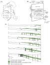 Figure 1. (a) Location of study area and cross-section lines. (b) Lithostratigraphy of study area. Stratigraphy data from various sources, including Moore (1964; 1996), Rose (1972), and Garner and Young (1976). (c) Cross section illustrating Edwards aquifer strata and faults.
End_Page 136------------------------
REFERENCES
Garner, L.E., and K.P. Young, 1976, Environmental geology of the Austin area: an aid to urban planning: The University of Texas at Austin, Bureau of Economic Geology Report of Investigations No. 86, 39 p.
Moore, C.H., 1964, Stratigraphy of the Fredericksburg division, south-central Texas: The University of Texas at Austin, Bureau of Economic Geology Report of Investigations No. 52, 48 p.
Moore, C.H., 1996, Anatomy of a sequence boundary-Lower Cretaceous Glen Rose/Fredericksburg, Central Texas Platform: Gulf Coast Association of Geological Societies Transactions, v. 46, p. 313-320.
Rose, P.R., 1972, Edwards Group, surface and subsurface, Central Texas: The University of Texas at Austin, Bureau of Economic Geology Report of Investigations No. 74, 198 p.
End_of_Record - Last_Page 137-------
ACKNOWLEDGMENTS AND ASSOCIATED FOOTNOTES
1Bureau of Economic Geology, John A. and Katherine G. Jackson School of Geosciences, The University of Texas at Austin, University Station, Box X, Austin, Texas 78713
2Woodruff Geologic Consulting, Inc., 711 W. 14th Street, Austin, Texas 78701
Copyright © 2003 by The Gulf Coast Association of Geological Societies