About This Item
- Full text of this item is not available.
- Abstract PDFAbstract PDF(no subscription required)
Share This Item
The AAPG/Datapages Combined Publications Database
GCAGS Transactions
Abstract
Abstract: The Princess Discovery—Sub Salt Gulf of Mexico: Challenges of Sub-Salt Imaging in a Fast-Paced Sub-Sea Development: Abstract
Abstract
This paper will give (1) a brief overview of the Princess Field and its setting in the Mars Basin in the Gulf of Mexico, (2) discuss the strategy and maturation of the sub-salt seismic imaging and (3) analyze the impact on the field development.
The Princess discovery is located in 3700 ft of water on the northern flank of the Mars Basin on blocks MC 765 and 766 adjacent to the Ursa field (Fig. 1). Shell is the operator for BP, ExxonMobil and ConocoPhillips. Drilled in the year 2000 on a poorly imaged sub-salt truncation trap, the discovery well penetrated stacked Upper Miocene turbidite reservoirs.
Given the large uncertainty associated with the sub-salt setting, the development system was chosen to cater for many different outcomes. This resulted in a four-well 15,000 psi capable dual flowline sub-sea tieback to Ursa, which can be expanded in the future. First production was achieved late 2002 initially through a well drilled to Princess from the Ursa Tension Leg Platform (TLP), followed late in the year 2003 by the first production through the sub-sea system, some 3 ![]() years after discovery. Challenges that were met during the development not only pertained to the large subsurface uncertainty, but also to the complexity of drilling high angle extended reach wells through shallow hazard zones and depleted reservoirs. The Princess Field is currently (April 2005) producing approximately 45 MBOPD and approximately 95 MMSCFD through four wells from two different reservoirs.
years after discovery. Challenges that were met during the development not only pertained to the large subsurface uncertainty, but also to the complexity of drilling high angle extended reach wells through shallow hazard zones and depleted reservoirs. The Princess Field is currently (April 2005) producing approximately 45 MBOPD and approximately 95 MMSCFD through four wells from two different reservoirs.
The Princess Field is hidden completely underneath the East Antares salt body. At the time of discovery, the existing 3D data yielded no sedimentary details of the field or even the position of the large Antares salt overhang (Fig. 2). The discovery well was targeted on a limited depth-migrated long cable 2D image. A large range in the discovery volumes reflected the uncertainty associated with the limitations of seismic imaging below salt and the upside potential in untested stratigraphy and a possible waterflood. To support initial appraisal and development activities the first 3D image was obtained through executing a Pre-Stack Depth Migration (PSDM) on existing 1988 seismic data. This survey proved to be in a reasonable orientation to illuminate sub-salt, but lacked the offset range to provide more than a localized image of the field. Consequently a 3D seismic survey tailored to the specific sub-salt setting was acquired. This dataset has undergone various rounds of reprocessing using a number of pre-stack depth migration algorithms and velocity models (Fig. 3). Evaluation of this survey, integrated with well results and borehole seismic data, has provided a step change in the further characterization of the field. The seismic image at Princess is still evolving with technology in pursuit of further development opportunities in the field.
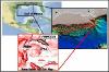 Figure 1. Princess Field location map.
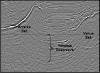 Figure 2. 3D time migrated image at the time of Princess discovery (N40W acquisition).
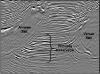 Figure 3. Current 3D pre-stack depth migrated image from dedicated N30E acquisition.
Acknowledgments and Associated Footnotes
1 Shell Exploration and Production Company, New Orleans
2 Shell Exploration and Production Company, New Orleans
3 Shell Exploration and Production Company, New Orleans
Copyright © 2006 by The Gulf Coast Association of Geological Societies