About This Item
- Full TextFull Text(subscription required)
- Pay-Per-View PurchasePay-Per-View
Purchase Options Explain
Share This Item
The AAPG/Datapages Combined Publications Database
Journal of Sedimentary Research (SEPM)
Abstract
Depositional Environment and Sequence Stratigraphy of Miocene Deltaic Cycles Exposed along the Jerudong Anticline, Brunei Darussalam
Stefan Back (1), Christopher K. Morley (1), Michael D. Simmons (2), Joseph J. Lambiase (1)
ABSTRACT
Kilometer-scale prograding clinoforms associated with deltas are rarely seen in outcrop; however, one such example is found in a Miocene sand-shale sequence exposed along the Jerudong anticline in Brunei Darussalam. Regional sequence stratigraphic interpretation shows that large clinoforms at the base of the Miocene Belait delta represent a succession of at least three major sand-shale sequences. The stratigraphically highest and best exposed sequence exhibits large slumps and sharp-based detached sand bodies at its base. Accumulation of these units most likely occurred during a relative sea-level lowstand. An overlying 1-1.5 km thick shale unit is interpreted to have developed during subsequent transgressive and early highstand conditions. Rapid progradation of thick sand-dominated shoreface deposits characterizes the late highstand systems tract. The clinoforms below show similar depositional geometries: slumps and thin blankets of shallow-marine sandstones mark the individual bases, shales and mudstones succeed, and progradational shoreface and tidal deposits form the top of each clinoform. New sedimentological and micropaleontological data document that all sediments (regardless of whether sand- or shale-dominated) formed in a shoreface to shelfal setting in front of a mud-rich delta. This differs from previous studies interpreting a continental-slope to deep-marine depositional environment for all shale-dominated units, and
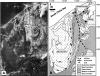 FIG. 1. A) Landsat satellite composite image of NE Brunei Darussalam (after Sandal 1996) and B) geological map (after Wilford 1961). The Belait Formation is dominated by shallow-marine shoreface and tidal sandstones. The Setap Shale Formation (Setap Shales) is mainly composed of shelfal mudstones and shales. Note pronounced progradational geometries at the base of the Belait Formation on the eastern margin of the Belait Syncline. Black boxes indicate locations of Figures 2 and 4.
End_Page 913------------------------
indicates that kilometer-scale clinoforms can develop entirely on the continental shelf in water depths less than 200 m.
Pay-Per-View Purchase Options
The article is available through a document delivery service. Explain these Purchase Options.
| Watermarked PDF Document: $14 | |
| Open PDF Document: $24 |