About This Item
- Full TextFull Text(subscription required)
- Pay-Per-View PurchasePay-Per-View
Purchase Options Explain
Share This Item
The AAPG/Datapages Combined Publications Database
AAPG Special Volumes
Abstract
Pub. Id:
First Page:
Last Page:
Book Title:
Article/Chapter:
Subject Group:
Spec. Pub. Type:
Pub. Year:
Author(s):
Fig. 1. Diagrammatic relief map to show some important topographic and structural features of Southern California.
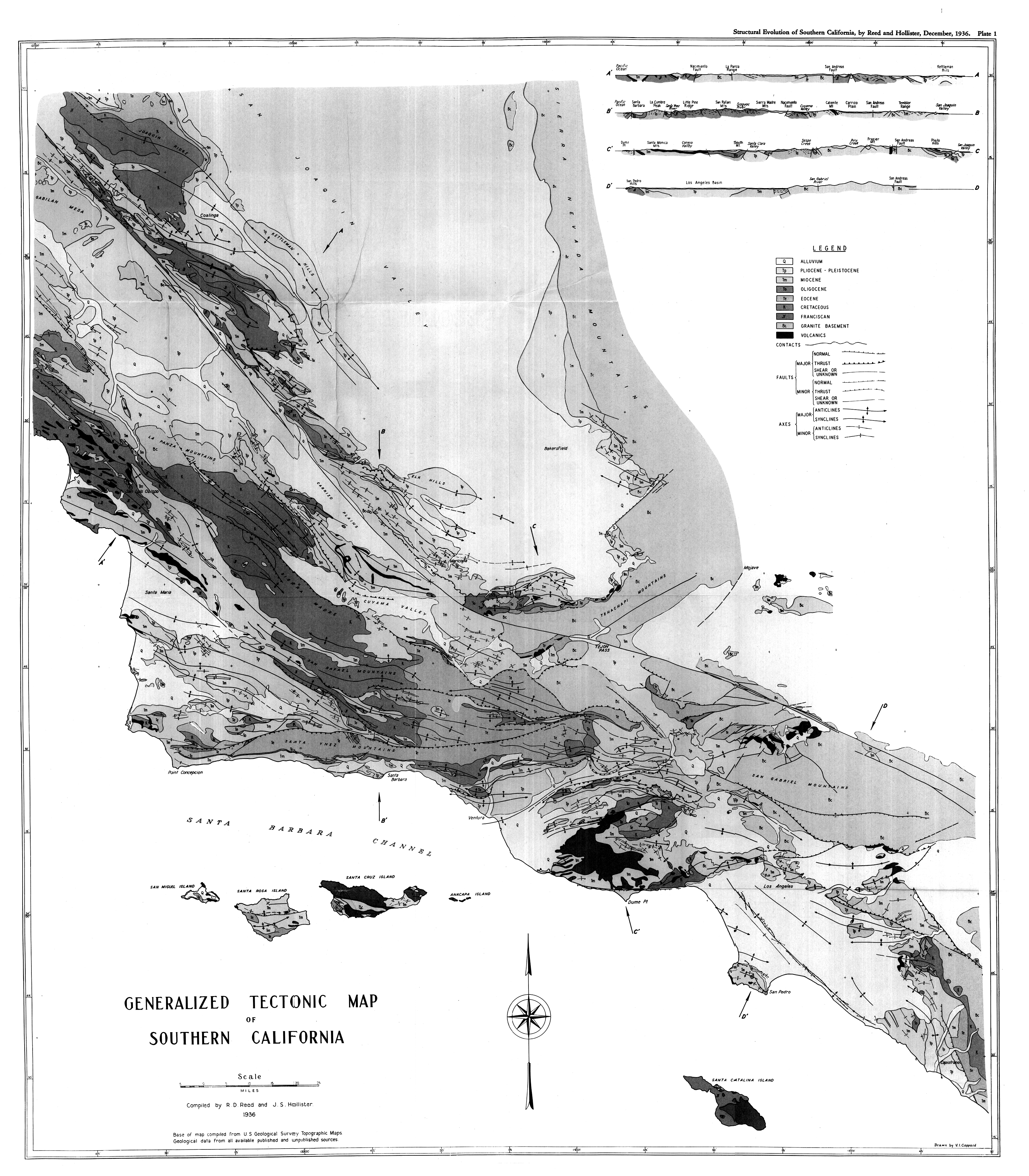
Fig. GENERALIZED TECTONIC MAP OF SOUTHERN CALIFORNIA - Oversized Image :click to view
Preface:
The structure of the Coast Ranges has been a subject of interest ever since the first geological expeditions came to California. A structure section from San Francisco to the Mother Lode was published as early as 1851. The geologists engaged in the surveying of routes for a Pacific Railroad about that time furnished additional structural information a little later. The first State Geological Survey, under the leadership of Dr. John B. Trask, gave some attention to the "Coast Mountains," but chiefly to their soils and mineral resources. During the sixties the Whitney survey sent men throughout the Coast Ranges and furnished a great deal of sketchy structural information.
About 1880 the State Mining Bureau was organized and the United States Geological Survey first sent men to work in California. Members of both these organizations have continued to give more or less attention to problems of Coast Range structure ever since. Their prime interest at first was in ore deposits and later in oil, but structural problems were involved in both. Shortly after 1890 H. W. Fairbanks published several structure sections along the lines of trails from one mining prospect to another in the San Rafael Mountain district. G. F. Becker gave many interesting structural data in connection with his study of the Coast Range quicksilver deposits. With the opening of the twentieth century, Eldridge, Arnold, Johnson, Anderson, and their associates and successors began mapping arge areas in the Coast Ranges in connection with increasing interest in oil possibilities. Even before this time, professors of geology in the University of California and Stanford were mapping quadrangles and studying structural problems in central California, but it was a long time before such work was extended to Southern California. In 1904 Fairbanks published the San Luis Folio, the only one that has yet appeared within our limits.
Of all the different types of work, Southern California received an important share only of that devoted to oil prospects. During the first 20 years of the present century most of this work was done by members of the United States Geological Survey, who published their results in a series of valuable bulletins, many of them provided with colored geological maps. Since 1920 nearly the whole of Southern California--as the term is used in the following discussion--has been mapped in considerable detail by oil geologists and others, but publication has been sporadic and incomplete. Structural problems have been foremost in the minds of the men engaged in this work, and
End_Page VII------------------------
many publications dealing with structural details have appeared. Many other structural problems and structural hypotheses are known and have been vigorously discussed by the men interested in them, even though nothing has been published about them.
From this historical sketch it will be obvious that any structural interpretation of Southern California must be based largely on the work of oil geologists; and that the adequacy of the data in different provinces will depend on how attractive each province has seemed to the oil-hunters. Thus Tertiary areas have in general been carefully mapped, Cretaceous areas less so, and pre-Cretaceous areas hardly at all.
In undertaking to discuss the structure of Southern California we have been limited partly by our data and still more definitely, perhaps, by our interests. We are not greatly attracted by some structural problems that seem fundamental to many geologists. The history of a structure interests us more than its mechanical cause. To call attention to this bias, we call our study "structural evolution." From the viewpoint of many of our colleagues we probably seem to be dealing only with the raw material of structural geology. We hope nevertheless that these men of different taste will be interested in our attempt to classify this raw material and present as much as possible of it in the form of maps, sections, charts, and diagrams.
This book is in a sense a sequel to Geology of California which contains only brief and casual discussions of the subject of structural evolution. In order to write the present account we found it necessary to compile many geologic data, some of which did not exist at the time the earlier book was written. This new information and some new ideas that developed during the acquisition and compiling of new and old information have led to conclusions not always in harmony with those previously expressed. In such cases we have tried to avoid consistency-at-any-price, and have stated the views that seem most in harmony with the facts now known to us.
Many of our present views have been more or less strongly held by many local geologists for years. In appropriating them and stating them as our own, we would avoid claiming them as original. As a matter of fact, we do not know which, if any, of the hypotheses and opinions we now hold are original with us. All of them are to be considered ours only in the sense that we now believe them to be more probable than the alternatives that have occurred to us.
The tectonic map, in particular, is a compilation and not an original work. It includes material drawn from nearly every published
End_Page VIII-----------------------
map available to us that shows geological data for any part of the area. For the areas of which no published maps exist we have drawn upon dozens of friends. At the risk of seeming partial, we wish to mention N. L. Taliaferro, H. G. Schenck, C. L. Gazin, Paul F. Kerr, W. D. Kleinpell, R. M. Kleinpell, T. Clements, A. I. Gregersen, E. R. Baddley, J. E. Eaton, and the late D. B. Seymour, all of whom have contributed important field data for larger or smaller areas. Our debt to these and many other friends and associates is very great.
In preparing the stratigraphic and other data shown in maps and charts and discussed in the text, we have likewise drawn upon all available sources of information. Some of our debts are acknowledged at appropriate places, but many others exist. Our chief excuse for not making greater effort to acknowledge specific obligations in more detail is that to do so would add very considerably to the bulk of our text. Another reason of much weight is the practical impossibility of remembering correctly how and when we obtained facts and ideas, the acquisition of which has covered several years and has involved hundreds of conversations with scores of geologists.
To our predecessors in the field of structural interpretation we wish to pay our respects in this place. Our plan of work and our desire to attain conciseness forbade making lengthy discussions of their work. We have nevertheless made use of the results of their labors, have appropriated some of them and rejected others, and been influenced even by the results we rejected, just as we expect our successors to do with our results. It would be an interesting task to write a history of structural interpretation in California, but it is not the task we set for ourselves in the present work.
Dr. Hans Ashauer drew a considerable number of our maps and diagrams; from his extensive knowledge of European geology and of the ideas of European geologists he was also of great assistance to us in our attempts to classify and interpret Coast Range phenomena. Mr. J. E. Eaton put us greatly in his debt by a critical reading of the manuscript. Mr. V. Coppard drew the geological map and many of the text figures. Many other friends and associates contributed in different ways.
Among recent writers on the problems of structural interpretation we are particularly indebted to three: Professor W. H. Bucher, author of The Deformation of the Earth's Crust; Professor S. von Bubnoff, author of Grundprobleme der Geologie; and Professor Hans Stille, author of Grundfragen der vergleichenden Tektonik. To the last-named geologist our debt is of so special a character that we have attempted to acknowledge it by dedicating this study to him.
End_Page IX-------------------------
For permission to make the investigation upon which our text is based, and to publish some of the scientific results, we are deeply indebted to The Texas Company, and particularly to Mr. J. A. Bermingham, vice-president and manager of the producing department for California.
R. D. REED
J. S. HOLLISTER
LOS ANGELES, CALIFORNIA
September, 1936
Errata:
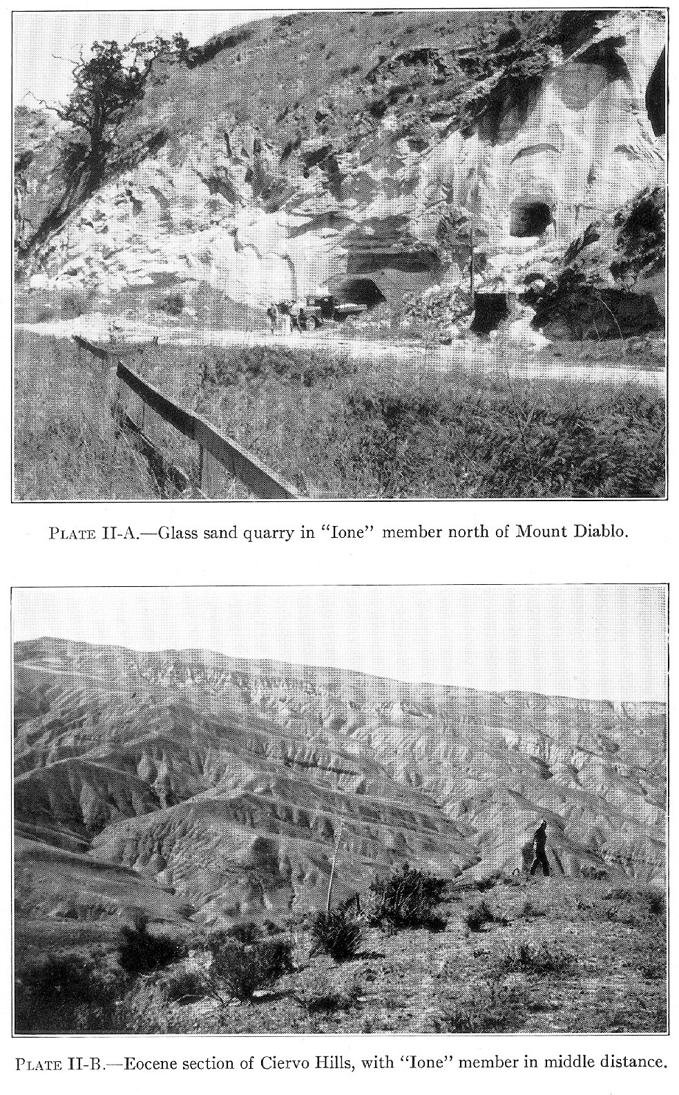
(1) Fig. 2, p. 3. The black splotches 20 miles north of Los Angeles are smudges and do not represent Franciscan. Small masses of granite shown near Bakersfield and four small Franciscan areas south of Los Angeles are known from wells, not from outcrops.
(2) Figs. 9 and 10, pp. 20 and 21. "F" indicates megafossil horizon, "f" microfossil horizon, "V" vertebrate fossil horizon.
(3) P. 49, fourth line from bottom: "at" should be "as."
(4) P. 53, line 4. This promised discussion is in the following chapter, which was separated from "this chapter" months after the writing of this sentence.
(5) P. 61. According to M. N. Bramlette (Bull. Amer. Assoc. Petrol. Geol., Vol. 18, No. 12 (December, 1934), P. 1569), the Big Blue equivalent belongs in the sandstone series immediately above the "Upper Variegated."
(6) Plate VIII-B, opp. p. 98: "on" in second line of title should be "of."
(7) Fig. 44, p. 119. This structure section represents conditions at the end of the Miocene--not present structure.
Pay-Per-View Purchase Options
The article is available through a document delivery service. Explain these Purchase Options.
| Watermarked PDF Document: $14 | |
| Open PDF Document: $24 |