About This Item
- Full TextFull Text(subscription required)
- Pay-Per-View PurchasePay-Per-View
Purchase Options Explain
Share This Item
The AAPG/Datapages Combined Publications Database
West Texas Geological Society
Abstract
Front Matter, Abstracts: West Texas Geological Society: Resource Plays in the Permian Basin: Resource to Reserves
 Figure.
| Section One: Technical Papers Table of Contents | |
|---|---|
| Editor’s Note: This Publication is divided into three sections (Technical Papers, Presentations, and Virtual Posters). Each section has its own Table of Contents with links to the items in that section. | |
| Front Cover | |
| Inside Cover: Permian Basin Stratigraphic Column | |
| i. | Reference Page |
| iii. | Section One Table of Contents (Alphabetical by Author) |
| v. | 2006/2007 WTGS Officers and 2006 Fall Symposium Committee Chairmen |
| viii. | 2006 Fall Symposium Sponsors |
| ix. | WTGS President’s Message |
| x. | General Chairman’s Message |
| xi. | A Note from the Technical Chairman |
| xii. | Letter from the Editor |
| Technical Papers | |
| 1. | George B. Asquith - Modeling the DEW Plot [Rt/Rw versus Rxo/Rmf] in Vuggy Reservoirs Using the Maxwell-Garnett Equation and the Lucia (1995) Petrophysical Classes |
| 9. | Mark Beach - Critical Reservoir Property Data for Shale Gas Exploration |
| 10. | Daniel Benedict - Ongoing Research in the Area of Tight Gas Sands: The FAST Consortium |
| 11. | Tom Bratton - New Wireline Sonic Technology for all Disciplines |
| 12. | Ronald F. Broadhead - Mississippian Strata of Southeastern New Mexico: Distribution, Structure and Hydrocarbon Plays |
| 27. | Eric D. Carlson and Tim E. Ruble - Devonian Oil and Gas Source in NW Paraguay San Alfredo Group Shales |
| 28. | Robert M Cluff - Barnett Shale-Woodford Shale Play of the Delaware Basin – Is it Another Giant Shale Gas Field in Texas? |
| 30. | Richard B. Coffin - Methane Hydrate Exploration: A Geochemical Focus Coupled with Geophysical Site Surveys |
| 32. | Daniel R. Cook - Separating Gas Reefs from Water Reefs in 3D Seismic Carbonate Plays of the Permian Basin |
| 34. | Daniel R. Cook and John M. Warn - Contrast Enhancement of 3D Seismic in the Rockies to Separate Sand from No-Sand |
| 35. | David J. Entzminger, Mark Sonnenfeld, Lyn Canter, Steve Gardner, and Gary Nordlander - What Do You Do, when Asked to Squeeze More Oil Out of an Old Field, Keystone, South Field, Winkler County, Texas |
| 36. | Juan-Mauricio Florez-Nino - Rock Physics Diagnostics of Siliciclastic Deposits |
| 37. | Brian Fuller and Marc Sterling - Reservoir Imaging with 3D VSP Shear Wave Data |
| 38. | Beatriz Garcia-Fresca and F. Jerry Lucia - Outcrop and Subsurface Comparison of Lithology Distributions in the Permian San Andres Formation-Implications for a Dolomitization Model |
| 50. | Chad Hartman - Recent Issues Associated With The Determination Of the Sorbed Phase Storage Capacity In Shales - Assessing the Viability of Shale Gas Plays |
| 51. | Peter Holterhoff - Evolving Depositional Sequences of the Cisco and Albany Groups, Eastern Shelf, Midland Basin: Icehouse vs. Transitional Greenhouse Architectures and Implication for Reservoir Heterogeneity |
| 53. | John C. Horne - Conventional Wisdom and Unconventional Plays |
| 55. | Daniel M. Jarvie - Exploring for and Producing Shale Gas: Application of Detailed Geochemical Data in Ascertaining Prospectivity and Producibility |
| 57. | Charles Kerans - Play Types and Production Characteristics of San Andres Reservoirs – The Original Permian Basin Resource Play |
| 59. | Rick Lewis - Evaluation of Gas Shale Reservoirs |
| 60. | Heloise B. Lynn and Walter S. Lynn - Azimuthal Variations in Reflection Seismic Data: Measurements Governed by the In-Situ Horizontal Stress Field and/or Vertical Aligned Fractures |
| 71. | Greg Meszaros and Paul Boonen - LWD Geosteering and Natural Fracture Identification in Horizontal Wells in Unconventional Reservoirs |
| 80. | Dr. Jennifer L. Miskimins - Unconventional Versus Conventional Reservoir Stimulation: What Are the Differences and the Challenges? |
| 84. | Seiichi Nagihara - Dust, Wind and Fire – Monitoring Natural Hazards on the Southern High Plains with MODIS Satellites |
| 86. | James Page - Results of Propellant Fracturing in a Colton Sandstone Block |
| 87. | Mark Pawlewicz - 1-D Burial History Modeling in the Permian Basin, Southeastern New Mexico and Western Texas |
| 88. | Ted Playton and Charles Kerans - Latest Wolfcampian Tectonism as a Control on Early Leonardian Carbonate Slope Channel Complexes, Victorio Flexure, West Texas |
| 104. | Scott R. Reeves (Presented by Reinaldo Gonzalez) - Probabilistic Reservoir Performance Forecasting for Unconventional Gas Reservoirs |
| 105. | Stephen C. Ruppel, Robert G. Loucks, Jeffrey Kane, and Wayne Wright Depositional History and Stratigraphy of the Barnett Shale in the Fort Worth Basin: Implications for the Permian Basin |
| 106. | Sam Z. Scott and Charles Kerans - Outcrop-Constrained Characterization of Along-Strike Variability in San Andres Formation Clinoforms: Last Chance Canyon, New Mexico |
| 107. | Jake Sharp - Upper Pennsylvanian and Lower Permian Phylloid Algal Mound Reservoirs, Southeastern New Mexico |
| 114. | Mark D. Sonnenfeld, Cynthia E. Black, K. Lyn Canter, David J. Entzminger, Stephen P. Gardner, David T. Greene, J. Stephen Harrell and Sue T. Reid - Development History and Reservoir Characterization of the “Would Have Limestone:” A Leonardian Toe-of-Slope Debris Flow Complex |
| 116. | Mark Tomasso, Florence L. Bonnaffé, David R. Pyles, Renaud Bouroullec, and David C. Jennette - Outcrop versus Seismic Architecture of Deep-Water Deposits: A Comparison Along a Slope-to-Basin Transect of the Brushy Canyon Formation, West Texas |
| 117. | Bob Trentham - The Delaware Mountain Group in the Sheffield Channel as a Target for CO2 Sequestration, Pecos County, Texas |
| 119. | Willis W. Tyrrell, Jr., Alvin H. Smith, John A. Diemer, and Gorden L. Bell, Jr. - Can Cisuralian Series (Leonardian and Wolfcampian) Boundaries be Mapped Regionally in the Northern Delaware Basin Area, New Mexico and West Texas? |
| 121. | Willis W. Tyrrell, Jr., Alvin H. Smith, John A. Diemer, and Gorden L. Bell, Jr. - Operational Wireline Log-Defined Cisuralian (Leonardian – Wolfcampian) Boundaries in the Northern Delaware Basin Area, New Mexico and West Texas |
| 146. | Mike Uland, James Gilman, and Hai-Zui Meng - Reservoir Characterization and Production Modeling |
| 147. | Doug Walser - Induced Fracture Azimuth and Stimulated Network Size Determination in West Texas Barnett and Woodford Shale Wildcatting |
| 148. | Patrick Walsh - Petroleum Resources of the Lower Brushy Canyon, Secretary of the Interior’s Potash Area, Southeast New Mexico |
| Standalone TIFF file – Garcia-Fresca and Lucia Plate # 1 | |
| Section Two – Presentations (in a Separate File with its own Table of Contents) | |
| Section Three – Posters (in a Separate File with its own Table of Contents) | |
2005 / 2006 WTGS Officers
| President | Peter H. Lufholm | Saga Petroleum |
| 1st Vice President | Tim Hunt | University Lands |
| 2nd Vice President | Rick Doehne | University Lands |
| Secretary | Cindy Bowden | Kinder Morgan CO2 Co. |
| Treasurer | Anita Jones | Cimarex |
| President Elect | Russell P. Richards | Great Western Drilling Co. |
| Executive Director | Paula Mitchell | West Texas Geological Society |
2006 Fall Symposium Committee Chairmen
| General Chairman | Greg Hinterlong | Chevron |
| Technical Chairman | Denise M. Cox | Independent Consultant |
| Editor | Michael Raines | PetroSource Energy Co. |
| Publicity Chairman | Rick Doehne | University Lands |
| Exhibitors’ Chairman | Sam Samford | Suttles Logging |
| Arrangements Chairman | Harvin Broughton | Schlumberger |
| Judge/Moderators’ Chairman | Teri McGuigan | Independent |
| Registration | Paula Mitchell, Patricia Blackwell, and DeDe Plank | |
President’s Message
The West Texas Geological Society would like to welcome you to the 2006 Fall Symposium “Resource Plays in the Permian Basin: Resource to Reserves.” This also marks our 80th Anniversary as an organization which began in 1926 in San Angelo, Texas. It wasn’t until 1952, when WTGS merged with the Midland Geological Society, that the Society as we know it today was formed. Since its inception, the Society has strived to provide for its members the latest techniques and thoughts concerning the finding and exploitation of the reservoirs of the Permian Basin. This year is no exception. We are continuing to build on last year’s theme of “Unconventional Reservoir Technology and Strategies” in presenting this year topics on low porosity or poorly connected porosity reservoirs, evaluation and completion aspects of shale gas plays, and play assessment, including log analysis rock physics, and seismic technology as applied to fractured and shale gas reservoirs.
This year also marks our first venture into a purely digital Symposium publication. As with all new endeavors we have encountered our share of frustrations. I am confident that you will find the forthcoming DVD as informative as our past publications. I am excited in that this format allows the Society to include more color illustrations in larger formats which were otherwise cost prohibitive in past publications. We have also included (augmenting the submitted papers, when allowed) the speaker’s PowerPoint presentations with notes, also in a PDF format.
I want to recognize and thank the speakers who have taken the time and effort to present at this years Symposium, without which we wouldn’t be here today. The exhibitors and sponsors have provided a great service to the Society by their support. Please show your appreciation by taking the time to review what they have to offer.
I would like to congratulate the Symposium Committee, Chaired by Greg Hinterlong for doing an exemplary job of putting together this pertinent but diverse program. Please join me in expressing your appreciation to all of the committee members. Special thanks go to Paula Mitchell and Pat Blackwell, without whose efforts the Symposium would not be a success.
Pete Lufholm
General Chairman’s Message
The cyclic nature of the petroleum industry has brought us back to “dust off” the Permian Basin for another look for hydrocarbons. The last downturn depleted manpower as significantly as reserves. By providing a forum for new ideas and application of new technologies, those remaining in the industry and those new to it will find just the right spark to find the new reserves. With the collection of tools and talent in one location, odds are good the right people and ideas will meld. The topics of this year’s symposium should enable us to push from the comfortable to the innovative in our quest for new reserves. It is my firm belief significant reserves remain within the basin despite the total number of wells already drilled. The first step to finding hydrocarbons in the ground is to see them in your mind. Our industry owes a debit of thanks to the many men and women who gave of their time and talents to make this symposium possible.
Gregory D. Hinterlong
Chevron
General Chairman
2006 WTGS Fall Symposium
Technical Chairman’s Note
This year’s Symposium addresses the hot topic of Resource Plays. As the Symposium name, “From Resource to Reserves” implies, we are addressing the vagaries of resource plays from depositional models and play concepts - to drilling and resource appraisal - to completion technology - to reserve reporting.
Our sessions reach out to the many disciplines that make a resource play successful. Carbonate and clastic sessions offer an opportunity to examine depositional components of poorly connected porosity and low permeability. The petrophysics and geophysics sessions address the technology cornerstone of resource play appraisal and development. Talks on horizontal drilling, logging tools, petrophysics, rock physics, geophysics, and completions stress the continual learning process that goes hand and hand with new technology developed for resource plays. It is interesting to note that Wall Street has opted to trade geologic risk in conventional plays for technological risk in unconventional plays.
This year’s Symposium also offers a special session on the “Reservoir Aspects of Shale Gas Plays.” From the Keynote Speaker’s perspective as a current Delaware Basin shale gas player, through state of the art coring, geochemistry, petrophysics, geophysics, reservoir modeling, and completions, it is a power-packed session addressing the risks and rewards of the Delaware Basin shale play.
I want to extend a sincere thank you to all the presenters who made time during an extraordinarily busy year to participate in this year’s Symposium. Your research and technology inspire all of us who work in the Permian Basin to continue the adventure from resource to reserves!
Denise M Cox
2006 WTGS Fall Symposium
Technical Chairman
Letter from the Editor
Introduction
Welcome to the 80th Anniversary of the West Texas Geological Society and the inaugural “fully digital” edition of the Symposium Volume. WTGS has seen a great many firsts since its official inception in San Angelo in 1926 (See Publication No. 73-62 for a review through 1968.) Many of these have led to valuable additions to WTGS, industry, science, local and state governments and/or our fellow citizens. Although it may be unrealistic to expect to contribute as much as the early giants of our Society, perhaps we will look back on this conversion and see a stepping stone to more easily accessible data for our members and future industry workers. In that same spirit of progress, WTGS President Pete Lufholm announced that our historical publications (many of which are out of print) are now available in PDF format, so our conversion away from paper is well underway.
The Logo
The traditional WTGS logo was first introduced as the emblem of the 1938 Mid-Year meeting of the AAPG in El Paso (hosted by WTGS). The logo was designed by Mr. H. Hilton Kaderli, a clerk / typist / draftsman for Skelly Oil Company (see Publications No. 38-4 and 73-62). The emblem captures the essence of a drawing (Figure 1) on the last page of the 1938 Program (No. 38-4). The drawing was an excellent reflection of the significance of field trips, and was captioned with the expression “This is what it was all about.” Because the drawing and the emblem really did capture what it was (and still is) all about, WTGS adopted the emblem in 1939, and it has remained unchanged over these 67 years, except for certain website applications, wherein the central circle has been extracted and used by itself.
 Figure 1. Page 63 from WTGS Publication No. 38-4. Is this the inspiration for our current Logo? It does reflect all of the elements of a good field trip, and is especially reminiscent of the landscapes of far West Texas. The spirit of this image is distilled in the traditional WTGS Logo.
A lengthy internet search by the editor’s wife, Sue Raines, indicated that Pearl (like the 30th Anniversary) or Diamond (like the 50th and 75th Anniversaries) is the symbol of the 80th Anniversary, so a “Pearl” theme was chosen. The editor drew two major variations of two major design concepts, one of which was a “necklace” theme suggested by Technical Chairman Denise M. Cox. The final 80th Anniversary Logo (Figure 2) was chosen by the WTGS Board and Symposium Committee Chairmen. It is a pearl necklace with the traditional WTGS Logo as the centerpiece. The choice of the pearl necklace is an appropriate symbol for the entire region at this point in history as well, considering the “string of pearls” concept popular with Greenhouse Gas researchers and politicians interested in geologic carbon sequestration and the reflection of that image in the Permian Basin. (The existing CO2 delivery infrastructure is the “chain” and the oil field storage sites are the “pearls.”) Like real pearls, old worn out oil fields start as irritants but years later become valuable commodities. In the case of the oil fields, the value comes with the addition of potential Enhanced Oil Recovery projects brought on by the increased availability and decreased cost of CO2, that might come about thanks in large part to incentives for capture and storage of anthropogenic CO2. Other projects like the potential FutureGen site near Odessa may bring even more value to the “pearls.”
 Figure 2. The 80th Anniversary Celebration: A string of pearls adds to the 67-year old traditional Logo to mark this occasion. Shading and highlights emphasize that our continuity with the past provides the light for today’s vision.
The traditional logo captures the essence of the 1938 drawing, but is more representative of all areas of the Permian Basin.
About Publication # 06-117 (A Virtual Book on DVD)
This DVD is set up as a virtual book in two sections, each with its own table of contents. Each table of contents has been set up with links to the author’s starting page. Section One is the traditional technical paper section, where authors may publish a paper, an extended abstract (with or without figures), or a standard abstract. This section was prepared before the symposium, and this is what will be available for those who wish to have a hardcopy (at reproduction cost, in black and white format) during the symposium. Section One is arranged in alphabetical order by first author’s last name. One oversized Plate (in tiff format) from the Garcia-Fresca and Lucia paper is included separately. Section Two is a copy of the author’s talk or virtual poster presentation (scaled at 3’ by 4’). These presentations are the actual PowerPoint© shows given by the authors during the symposium, and include the author’s notes (if any) for each slide. In order to make reference easier, slides / pages in Section Two continue from Section One. Section Two is in the order the presentations were actually given, and are therefore generally grouped by topics / themes. Since each author may have two entries by the same title in the digital book (one for the paper and one for the presentation), it is suggested that both sets of page numbers (separated by a comma) be included in the reference.
In addition to technical papers and author presentations, our DVD sponsor, Weatherford, Wireline Division (briefly Precision Energy, which merged the companies Computalog, Inc. and Reeves Wireline, Inc.) will be providing tool specifications and/or charts as separate file(s) on the DVD. Although these items are currently available from multiple sources, it is suggested that they be referenced as if they were supplements to Publication No. 06-117, since many of the sources may be difficult for future workers to readily locate.
This year, all convention luncheon speaker, Mr. Arlen Edgar, an independent geologist and prospector from Midland, will be presenting an Ethics course that qualifies for the license renewal requirements of the Texas Board of Professional Earth Scientists. Although he has no technical paper in Section One, Mr. Edgar has agreed to allow his presentation to be included in Section Two. Similarly, a few other speakers were not able to include an article in the technical session, but may have a presentation available. In other cases, certain authors only had permission to show (not publish) their talk. In those cases, the abstract (if any) may be the only information available to non-attendees.
Personal Thoughts
As worldwide production peaks, demand continues to increase, tensions between nations rise, and adequate alternative energy sources remain decades away, the need for domestic energy supply (in every nation) will continue to intensify. How can we meet these demands? Simple - we must remove hydrocarbons more efficiently from old fields and tap into reserves previously by-passed or technologically unrecoverable. So how do we do that? We can: use advanced recovery techniques; better understand the plumbing in our existing reservoirs; and produce products or look in places we have traditionally avoided. That, my friend, is what this year’s symposium is all about. So, let us learn from each other and seek out those hidden pearls.
Good Hunting!
Michael A. Raines
Editor, 2006 Fall Symposium
Critical Reservoir Property Data for Shale Gas Exploration
Mark Beach, TICORA Geosciences, Inc.., [email protected]
Shale gas resource plays have become an important unconventional exploration and production target for the petroleum industry. Acquisition of critical reservoir property data is required to make sound decisions regarding the commercial viability of prospective shale gas plays. Each shale gas reservoir is unique, situated at some point between the spectrum of rock types that differentiate coal and tight gas plays. As a triple porosity system, shale gas reservoirs possess the ability to store gas by compression (as free gas in open macro-porosity and fracture systems), by sorption (adsorbed gas on surface area of micro- and mesoporosity), and in solution (dissolved gas in formation fluids). Recent advancements in the assessment of sorption behavior and “routine” core analysis (porosity, permeability and fluid saturation) are applicable to shale reservoir characterization. Unfortunately, there are no universally recognized standards for these technologies. This study will identify data sets that are routinely acquired to characterize gas shale properties and identify those areas where additional work is needed.
Ongoing Research in the Area of Tight Gas Sands: The FAST Consortium
Daniel Benedict, M.S. Candidate, Colorado School of Mines, [email protected]
The Fracturing, Acidizing, Stimulation Technology (FAST) Consortium, housed at the Colorado School of Mines, is sponsoring several ongoing research projects targeting the area of hydraulic fracturing stimulation. The mission of FAST is to perform practical research in the area of oil and gas well stimulation that can be directly applied for the enhancement of hydrocarbon production while providing the opportunity for graduate students to work on industry-sponsored projects. This poster provides a synopsis of the various research areas and results from the FAST Consortium that relate specifically to tight gas sand completion and stimulation techniques. One project focuses on height containment of hydraulic fractures in the fluvial environments of the Piceance Basin of Colorado and the Green River Basin of Wyoming. This project concentrates on detailed stimulation modeling and determination of essential field data acquisition. A second laboratory-based project, also focused on height containment, concentrates on the interaction of hydraulic fractures with “natural” fractures. The third project centers on “slickwater” fluid transport of hydraulic fracturing proppants in tight gas sands, as well as, shale gas systems. A fourth project is focused on improving the industry’s understanding of hydraulic fracture reorientation in relationship to changing effective stresses which can have a large effect on reserve recovery in tight gas situations.
New Wireline Sonic Technology for all Disciplines
Tom Bratton, Schlumberger, [email protected]
Wireline sonic technology is advancing rapidly. New data and techniques are extending the historical solutions beyond the realm of the geophysicist. Sonic logs are now contributing to petrophysics by identifying which zones will produce gas and which zones will produce water. They contribute to geology by providing unambiguous discrimination of drilling induced fractures from open natural fractures. Sonic logs contribute to geomechanics by quantifying the different sources of anisotropy such as stress. Several different applications will be presented that show how multiple disciplines can benefit from this new technology.
Devonian Oil and Gas Source in NW Paraguay San Alfredo Group Shales
Eric D. Carlson, P.G. [email protected] - Skype: aecarlson77224 and Dr. Tim E. Ruble, Humble Instruments & Services, Inc., [email protected]
Recently acquired (2006) geochemical data from the CDS-GM-05-5001 well in NW Paraguay confirm that the Devonian San Alfredo Group is a prospective source for oil and gas generation. Analyses of headspace gases, sidewall cores, and cuttings from a depth range of 500 m (1640 ft) to 1,597 m (5,240 ft) have been used to assess hydrocarbon generation potential and pore fluids. Using TEGC (thermal extraction gas chromatography), measurable hydrocarbons were recovered from all SWC samples analyzed. In six cuttings samples from the Devonian, the TOC (total organic carbon) decreases from 1.59% at 897 m (2, 943 ft) Measured Depth (MD) to 0.88% at 1,597 m (5,240 ft) MD. At that depth, kerogen is estimated to have undergone 64% conversion, based on declines in the HI (hydrogen index) with increasing depth. Original organic matter type is interpreted to be a mixture of oil / gasprone Type II / III marine kerogen from Rock-Eval data. Pristane / phytane ratios and the distribution of alkanes suggest a low sulfur marine shale source with dominant Type II organic matter, deposited under oxic to suboxic conditions. There are no indications of secondary alteration of these hydrocarbon fingerprints by biodegradation, water washing, or contamination. A calculated maturity depth profile suggests that the conventional oil window extends from above the shallowest Devonian sample at 750.5 m (2,462 ft) to a depth of 1,780 m (5,840 ft) MD. A straight-line projection below the well places the top of the dry gas window at 2,900 m (9514 ft) MD. In contrast, the TOC of overlying Carboniferous samples is inadequate for generating hydrocarbons. Projection of the linear maturity depth profile to the surface supports a post-Carboniferous erosional event in this well and elsewhere in NW Paraguay. In general, the tops and bases of the hydrocarbon windows of NW Paraguay are relatively flat, and cut across lithological and chronostratigraphic boundaries. Devonian oil and gas generation is associated with formation pore pressure between 9.5 and 12.3 pound per gallon mud weight. This source is the lateral stratigraphic equivalent of Devonian shales of eastern Bolivia, and has similar properties.
Methane Hydrate Exploration: A Geochemical Focus Coupled with Geophysical Site Surveys
Richard B. Coffin, Naval Research Laboratory, [email protected]
The Naval Research Laboratory, through wide spectra of national and international collaborations, is participating in gas hydrate exploration in a variety of coastal regions. Sites that have been recently studied include, Cascadia Margin, Texas-Louisiana Shelf, Hikurangi Margin along the northeastern coast of New Zealand and the Mid Chilean Margin. Hydrate exploration and research combines geochemical parameters from piston coring and heatflow probing with deep sediment seismic profiles to survey hydrate distribution and biogeochemical cycling of the hydrate gas. Research topics addressed in this project include coastal sediment geoacoustic and geotechnical properties, geochemical evaluation of vertical gas flow to predict deep sediment deposits, gas source variations within and between coastal regions, microbial cycling of methane, and the contribution of the gas to water column carbon cycling. Seismic surveys are applied to determine coastal regions with strong BSRs and BSR blanking regions and constrain interpretation of the geochemical data. Piston cores are analyzed for hydrate presence, pore water and sediment chemistry and the source of the methane in the hydrates. Heatflow is measured for analysis of the vertical fluid migration and is coupled with the seismic and geochemical data.
Geochemical parameters for the pore water data include methane, sulfate, chloride and dissolved inorganic carbon concentrations (DIC) and stable carbon isotope ratios of methane and DIC. Pore water geochemical data are plotted for comparison of methane and sulfate concentrations to assess the varying degrees of vertical methane fluxes and resulting methane oxidation. DIC concentrations and stable carbon isotope analysis are used to assist in the interpretation of the sulfate and methane profiles. High variation of chloride in vertical profiles indicates the presence of hydrates in the piston cores. Stable carbon isotope analysis is used to determine if methane is thermogenic or biogenic in origin and interpret biological cycling of the gas. Radiocarbon isotope coupled with stable carbon isotope analysis is applied to trace the methane cycling through biogeochemical cycles in the sediment and pore water. A thorough survey of gas cycling requires analysis of organic and inorganic carbon pools in the sediment and pore water, isotope analysis of microbial biomarkers and variations in community diversity.
This presentation will cover results from studies on the recent and current sites in which NRL is involved in collaborative exploration. Key results from the field surveys include: 1) Large variation in the vertical methane flux through sediments that is coupled with “wipe out zones” in the BSR and active fluid migration. In some regions sulfate is limited relative to the vertical methane flux, resulting in the contribution of energy to the water column. 2) Influence of physical and biological parameters on the pore water sulfate profile. 3) Relatively small spatial scale variation in methane sources. 4) Corresponding vertical variation in carbon isotope signatures of dissolved organic carbon and methane that correlate with the analysis of microbial community diversity and biomarkers.
Separating Gas Reefs from Water Reefs in 3D Seismic Carbonate Plays of the Permian Basin
Daniel R. Cook, Seismic Insight, Inc., [email protected]
Seismic Insight, Inc. conducted a study to determine the feasibility of using a new software technology, termed Event Resolution Imaging (ERI), to use 3D seismic data to separate gas wells from water wells. A further aim of the study was to determine whether or not Event Resolution Imaging could be employed to separate Economic gas wells from Non-Economic gas wells by analyzing 3D seismic data. These studies were carried out by using ERI to optimally combine 3D seismic waveform information with well production information to produce a Contrast Map.
The basic function of Event Resolution Imaging, as applied to 3D seismic data, is to use the well production information as labels for the 3D seismic waveform information. ERI uses production labeled seismic traces to find contrast signals within the 3D seismic data that provide robust separations between good wells and bad wells, or State A wells and State B wells.
In Event Resolution Imaging, the individual seismic traces in the vicinity of existing bore holes are analyzed to discover useful patterns in the 3D seismic data which robustly discriminate between any two states; state A and state B. For example, state A could represent an Economic gas well and state B could represent a Non-Economic gas well. As yet another example, state A could represent a high production oil well and state B could represent a low production oil well, or dry hole. In this way, Event Resolution Imaging employs mathematical information found in 3D seismic data to separate two distinct states, state A and state B, based on the known characteristics and the known production levels of existing wells.
In some ways, Event Resolution Imaging behaves like a neural network in that it learns from the seismic traces around existing wells. However, strictly speaking, ERI does not employ neural network technology to do its learning because it does not use back propagation or gradient descent. In addition, ERI does not use traditional discriminant analysis, linear regression, non-linear regression or any type of algorithm which attempts to minimize a least squares equation in order to minimize the metric distance between target values and actual values.
What Event Resolution Imaging does do is rely upon a computationally intensive method of simple counting and sorting, thereby employing the awesome power of the modern computer to simply step into, and sort through, a large number of separation landscapes, with each landscape being spanned by a number of features, characteristics or mathematical attributes of the 3D seismic signal. Attributes such as amplitude, frequency and phase relationships are encoded in signal features via an “Interpret-ation Key” which are composed via appropriate feature weights to generate a composite attribute value or activation value which is plotted on a Key Activation Plot (KAP).
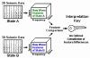 Figure 1. ERI Learning Process
Contrast Enhancement of 3D Seismic in the Rockies to Separate Sand from No-Sand
Daniel R. Cook, Seismic Insight, Inc., [email protected]
John M. Warn, Stephens Energy Co., [email protected]
Seismic Insight, Inc. conducted a study to determine the feasibility of using a new software technology, termed Event Resolution Imaging (ERI), to use 3D seismic data to separate Sand wells from No-Sand wells. A further aim of the study was to determine whether or not Event Resolution Imaging could be employed to separate Economic gas wells from Non-Economic gas wells by analyzing 3D seismic data. These studies were carried out by using ERI to optimally combine 3D seismic waveform information with well production information to produce a Contrast Map or Contrast Volume.
The creation of a 3D Contrast Volume shows the optimal composition of 3D seismic waveform information and well production information to generate a 3D Contrast Volume. The basic function of Event Resolution Imaging, as applied to 3D seismic data, is to use the well production information as labels for the 3D seismic waveform information. ERI uses production-labeled seismic traces to find contrast signals within the 3D seismic data that provide robust separations between good wells and bad wells, or State A wells and State B wells.
![]() Figure 1. Creation of a 3D Contrast Volume
Figure 1. Creation of a 3D Contrast Volume
What Do You Do, when Asked to Squeeze More Oil Out of an Old Field, Keystone, South Field, Winkler County, Texas
David J. Entzminger,1
Mark Sonnenfeld,1
Lyn Canter,2
Steve Gardner,1
Gary Nordlander,1
1 Whiting Oil an Gas, Inc.
2 Applied Geoscience Inc.
Squeezing more hydrocarbons out of an old field means that we go back to the basics and look at the rocks. Keystone, South was discovered in 1948 by Gulf Oil Company. The field produces from the Lower Clear Fork, Wichita, Wolfcamp, Mississippian, Devonian, Silurian, McKee, and Ellenburger. Most of the 7.55 MMBOE has been produced from the Lower Clear Fork reservoir. Primary production from typical Leonardian reservoirs in the Permian Basin is about 8-15% and another 5-12% from secondary recovery.
In 2004, Whiting Oil and Gas Corporation purchased the Keystone South, Field from Crownquest. In an effort to capitalize on the acquisition, 12 wells were drilled testing various ideas in and around the field with nine specifically targeting the Lower Clear Fork and Wichita. The production results from this drilling program varied significantly. Management asked, “is this all that we can expect?”
During the drilling program, 639 feet of core were taken. Modern logs suites were run. Wells were mudlogged, and several completion strategies were attempted. We went back to the rocks for answers to the mixed program results. After reviewing 525 feet of Lower Clear Fork core from four wells, a picture of the Lower Clear Fork reservoir emerged. Paleostructure influences reservoir facies distribution, lithology (limestone vs dolomite percentages), and karsting. It also affects the present day structure that contributes to where the highest oil saturation occurs. Understanding the facies, reservoir rocks distribution and structural influences help: explain the program results, define areas of future development, point to recompletion and stimulation opportunities, and improve water-flood performance.
Rock Physics Diagnostics of Siliciclastic Deposits
Juan-Mauricio Florez-Nino
iReservoir.com, [email protected]
Sandstones and shale present characteristic trends in cross plots of P-wave velocity - porosity (Vp-Φ). Assuming similar fluid saturation, the slope of the variation in velocity with respect to the change in porosity can be used to diagnose the geologic and geomechanical factors controlling velocity. Geologic factors are mineral composition, compaction, cementation, pressure solution, clay content, mm- to cm-scale fabric, and sorting. Main geomechanical factors are effective confining pressure and presence of microcracks. The trends of these different variables can be predicted based on both empirical and heuristic rock physics models. This way, we can use rock-physics diagnostics to identify the geologic and geomechanical variables con-trolling the elastic properties of reservoir rocks.
In addition to this, lithofacies successions from diverse depositional environments show distinctive patterns in various rock-physics planes (Vp - Φ, Vp - density and porosity - Vclay). These patterns are the consequence of textural and compositional variations in the mm- to cm-scale fabric associated with the mechanics of deposition, and coeval post-depositional processes like bioturbation. Four clear examples of decameter-scale lithofacies sequences are documented:
-
fluvial deposits from the Miocene of Colombia show an inverted-V pattern indicative of mm- to cm-scale dispersed fabric in mixed lithofacies;
-
a fining-upward lithofacies sequence of mud-rich deep water deposits from offshore West Africa shows a linear trend associated with mm- to cm-scale horizontally laminated sand-clay mixtures;
-
sand-rich deep water deposits from offshore Gulf of Mexico present a pattern resulting from the scarcity of mixed lithofacies; and
-
a coarsening-upward lithofacies sequence of shallow marine deposits from Colombia presents evidence of both dispersed and horizontally laminated mixed lithofacies, with predominating dispersed mixtures generated by bioturbation.
Rock-physics models provide the framework to differentiate, based on well log data, the effects of lithofacies, fluid saturation, and pressure on the elastic properties of rocks.
Reservoir Imaging with 3D VSP Shear Wave Data
Brian Fuller, HiPoint Reservoir Imaging, [email protected]
Marc Sterling, HiPoint Reservoir Imaging, [email protected]
Within the past year downhole seismic receiver equipment has become available that provides higher data recording capacity and significantly higher signal fidelity than many previously available downhole receiver systems. The recording equipment has allowed highquality shear wave reflections to be recorded in 2D VSP and 3D VSP datasets. Shear wave reflections are in the form of P-S converted reflections and S-S reflections. The shear wave VSP data has been processed to create 3D P-S and 3D S-S reflection images. The availability of S-wave reflections provides the potential to extract reservoir properties that cannot be extracted from P-wave reflection data alone.
Recent Issues Associated With The Determination Of the Sorbed Phase Storage Capacity In Shales - Assessing the Viability of Shale Gas Plays
Chad Hartman, TICORA Geosciences, Inc., [email protected]
Many of the techniques and methods used to determine sorbed phase storage capacity in coals do not translate well when analyzing fine grained sedimentary rocks such as shales. Shales differ greatly from coals, consisting mostly of mineral matter and containing mobile oils, clays, silts and very little organic carbon. Furthermore, most shale reservoirs have temperature and pressure regimes that are rarely encountered in coals.
Shales tend to have matrices far more complex than that found in coals. Geochemistry, mineralogy, free gas porosity, Tmax values and TOC are key variables that can be utilized to define the total gas storage capacity in shales. These key parameters will be discussed and data will be presented to show various correlations and relationships associated with them and total gas storage capacity. None the less, the knowledge and concepts understood, that help the oil and gas industry to define the viability of a shale play, are far outweighed by what is not yet understood. Some of these shortcomings and remaining hurdles will be discussed.
When performing volumetric isotherm analysis, the only data acquired are pressure and temperature data over time. Utilizing an equation of state, material balance equations are used to determine how many moles have sorbed to the rock matrix for a given equilibrium pressure. Historically, researchers investigating the sorbed gas storage capacity in coals came to understand that the measured isotherm required a correction factor to compensate for the decrease in available porosity as sorption increases. Data will be presented that brings into question the viability / necessity of such a correction factor when analyzing shales.
Unlike coals, that are generally shallow, thin, and cool in the geological setting, shales can often be quite thick and deep, having reservoir temperatures and pressures upwards of 300 °F and 12,000 psia respectively. Sorption isotherm analysis only holds value if the experiment is conducted at conditions that reflect in-situ reservoir parameters. The logistics of performing isotherms on shales that have such extreme reservoir properties is quite complex and often not practical, yet the desire for such data still remains. Strategies are presented that allow the sorbed storage capacity data of extreme reservoir conditions to be acquired while remaining within the practical bounds of current instrumentation technology.
Evolving Depositional Sequences of the Cisco and Albany Groups, Eastern Shelf, Midland Basin: Icehouse vs. Transitional Greenhouse Architectures and Implication for Reservoir Heterogeneity
Peter Holterhoff, Department of Geosciences, Texas Tech University, [email protected]
The geological record can be grossly divided into time intervals dominated by “greenhouse” or “icehouse” climate regimes. Greenhouse climate periods are characterized by warm Boreal climates and a lack of continental glaciation. The product of this climate regime is low amplitude, high frequency (Milankovitch band: 20 – 400ka) global eustasy. Thus, green-house depositional systems should be dominated by a nested hierarchy of accommodation drivers, with low amplitude, high frequency changes in relative sea–level modulated by higher amplitude, longer term accommodation trends. The resulting depositional sequences should be com-posed of well–organized parasequence sets building large–scale sequences. Alternatively, icehouse climate regimes are characterized by well–developed continental glaciation resulting in pronounced high amplitude, high frequency global eustasy. In this case, icehouse depositional systems should record high amplitude, high frequency changes in relative sea-level that can overwhelm or mask lower frequency signals. This should produce stratal packages with significant lithofacies juxtaposition and numerous unconformities, resulting in complex, small-scale sequences.
This study seeks to compare the sequence architectures and lithofacies composition of Cisco Group strata, deposited during the fully icehouse Late Pennsylvanian and earliest Early Permian, to Albany Group strata, deposited during the later Early Permian transition into greenhouse conditions. Preliminary examination of outcrop and the literature reveals patterns consistent with that predicted by the models described above. Cisco Group sequences of the upper shelf region are thin and composed of well-developed open shelf carbonates with fusulinids and / or condensed, conodontrich shale in the transgressive systems tract / maximum flooding horizon. These flooded-shelf lithofacies often abruptly overlie paleosols or incised valley fills representing exposed shelf conditions during lowstands. High-stands are composed of relatively thin shoaling carbonate or siliciclastic depositional systems. Albany Group sequences stand in strong contrast, as distinct drowned shelf or condensed section lithofacies are not developed in the upper shelf region. Instead, inner platform carbonate para-sequences stack to form thick aggradational packages that modulate with coastal and alluvial siliciclastic depositional systems. These parasequence sets stack to form thick depositional sequences.
Age-equivalent strata in the subsurface of the northern Midland Basin display similar stratal patterns and sequence architectures. “Wolfcamp” platform and margin systems are highly variable while the Wichita systems are well defined. This contrasting style of organization has a significant impact on reservoir development.
Conventional Wisdom and Unconventional Plays
John C. Horne, Norwest/Questa Engineering, [email protected]
Throughout the history of oil and gas exploration, “conventional wisdom” has retarded new ideas in the hunt for unfound oil and gas resources. This has provided opportunity for explorationists too dumb or naïve to know they should not go against “conventional wisdom.” In the 1890s, “conventional wisdom” said there was no oil in East Texas. Wrong! In The 1920s, everybody knew there were no hydrocarbons in West Texas. Wrong again! The oil and gas industry is replete with examples of how oil and gas was found in the minds of people unwilling to accept “conventional wisdom.”
In retrospect, most of the oil and gas found in the latter part of the 19th Century and well into the 20th Century were the “low hanging fruit.” the easily found reserves. How-ever, at the time of discovery, many of the explorationists’ ideas were considered radical. Now, they seem conventional and rather mundane. Twenty-twenty hindsight is always perfect!
In the latter part of the 20th Century and to the present, the industry has moved toward more unconventional reservoirs to replace production as the United States oil and gas reserves began to decline precipitously. Because the price of oil and gas remained low, operators looked for plays that had a high potential for success and were repetitive with respect to drilling and completion technology. In most instances, the unconventional plays were already known, but “conventional wisdom” said they could not be successful. “Everybody knows sandstones in the deeper parts of basins are too tight to be economic reservoirs.” “Sure, coals make a little gas, but permeability is too low and storage capacity is not sufficient to provide an economic reservoir.” “Yeah, source shales generate hydrocarbon, but they never have enough porosity and permeability to provide economic wells.” Ultimately, the success of these resource plays depended on “best practices” drilling and completion technology. Sometimes, the technology was innovative and new, while other times it was the application of established technology in new ways.
These resource plays have evolved in an accelerating and overlapping timeframe from tight sandstones to coal bed methane, to oil and gas shale reservoirs. In each instance, the play was known, but “conventional wisdom” indicated it could not be economically successful. Some successes (tight sandstones and shale plays) were due to advances in technology or rethinking of drilling and completion strategies. Other plays (coal bed methane) were successful initially due to tax credits.
Early resource plays such as the tight sandstones evolved slowly, partially due to low energy prices. Mostly, however, it was due to “conventional wisdom” indicating it could not be successful. Once proven successful, the rush was on to lease land and develop the resource. However, not all companies were successful or manage to establish a position in the play. As new unconventional resource plays evolved, those that missed on the previous plays were determined to establish themselves in the new plays. Thus, each new unconventional play has evolved more rapidly than the previous. As a result, the latest resource play (gas shales) has large portions of available land already leased.
For this reason, the obvious question is, what is the next unconventional resource play? Ask yourself the question, where are there large known hydrocarbon resources? Then, ask your-self the question, does conventional wisdom indicate that it cannot be economically successful? The third question should be is the technology available to make the play successful? The answer to these questions will lead you to the next unconventional play. Come hear where that takes me.
Exploring for and Producing Shale Gas: Application of Detailed Geochemical Data in Ascertaining Prospectivity and Producibility
Daniel M. Jarvie, Humble Geochemical Services, [email protected]
Production of hydrocarbons from source rocks is classified as an unconventional resource primarily due to productive hydrocarbons being produced from very low permeability, low porosity shales. Shales can be oil productive, but require higher pressures or a high degree of fracturing to obtain commercial oil flow rates (e.g., Bakken, Monterey). Source rocks can be good reservoirs for gas, although trade-offs between flow rates and gas yields must be considered in the economics of development. High flow rate systems such as the Barnett Shale of the Ft. Worth Basin contain highly mature, high TOC marine shale organic matter that derives gas from two processes – directly from organic matter decomposition and secondarily, from secondary cracking of generated oil that is retained in the source rock network. Gas is stored primarily in micro-reservoirs that are isolated pore spaces associated with the change in volume from organic matter conversion or micro-fractures induced from generation or other alteration processes.
Typical shale gas systems are typically Devonian or Mississippian in age with the Devonian being very high in TOC and generally higher maturity than Mississippian shales. Higher TOC contributes both increased quantity of hydrocarbons, but also increased porosity due to organic matter conversion. Other shales such as Permian and Pennsylvanian shales in West Texas and Oklahoma will also likely prove to be viable reservoirs for gas since they are often shallower, but at gas window thermal maturity, in areas where the Devonian and Mississippian systems may be too deep to pursue given present-day constraints on drilling and associated costs.
Lower maturity shales such as the Devonian New Albany Shale in Kentucky are proving to be viable thermogenic shale gas systems, but they contain lower recoverable amounts of gas quite simply due to gas being derived from incipient gas generation from organic matter. These systems are viable primarily due to depth and lower drilling costs.
Many shale systems also contain conventional reservoirs or tight gas sands. The Delaware Basin is one such intriguing hydro-carbon system, as it a combination system with conventional systems (up to 15% of which have been by-passed based on estimates by Exxon in 2000) and unconventional shale gas systems, such as the Barnett and Woodford shales, and tight gas sands such as found in Haley Field in Loving County and elsewhere.
In the Delaware and Palo Duro basins, shale gas success has been difficult to achieve for a variety of reasons. While the Penn. shales of the Palo Duro Basin do not show high TOC and thermal maturity, Barnett and Woodford shales of the Delaware Basin do suggest a high degree of organic matter conversion such that EURs should be even higher than what has been achieved in the prolific shale gas system of the Ft. Worth Basin. Seismic data will likely be more important in the Delaware and other basins due to faulting and the need to stay in zone for horizontal drilling and avoidance of Ellenberger water.
Play Types and Production Characteristics of San Andres Reservoirs – The Original Permian Basin Resource Play
Charles Kerans, Department of Geological Sciences, The University of Texas at Austin [email protected]
The San Andres Formation of the Permian Basin has accounted for 9.7 Billion bbl of cumulative production from 120 reservoirs each with greater than 1 MMB cumulative production (Dutton et al, 2006). This resource, though all from one “formation,” produces from a wide spectrum of different stratigraphic architectures, facies, and both primary and secondary pore networks. Characterization of these facies-production relationships supported infill in the 80’s and 90’s and more recently have encouraged hydraulic fracturing of low permeability facies.
The San Andres Formation is the carbonate-dominated shelf record of two composite sequences (P5CS and P6CS) and 10 high-frequency sequences (L7-L8, G1-G9). Basin-restricted Brushy Canyon sandstones comprise G5-7 HFS of the P6CS lowstand. Cherry Canyon Tongue sandstones represent the LST-early TST G9 HFS. The Lower San Andres composite sequence (P5CS) initiated in latest Leonardian (Kungurian) time with a global transgression. Only minor reservoir development is associated with these TST sequences (L7, L8) because intra-San Andres seals are generally lacking. The majority of the giant San Andres fields, including Wasson, Slaughter-Levelland, Seminole, and Goldsmith, all produce from the P5CS highstand sequence set (G1-G4) with top-seals being formed by prograding evaporites. Large San Andres fields developed in the Upper San Andres composite sequence (P6CS) include reservoirs like Vacuum, Monument, and Maljamar near the San Andres terminal shelf margin on the Northwest Shelf, where the karst overprint is minimal due to evaporite plugging. Karst-modified platform-margin fields on the NW (Hobbs) and SE (Yates) corners of the Central Basin Platform where evaporites have been removed by late diagenesis are characterized by complex dual-porosity systems.
Within this stratigraphic framework it is possible to recognize five broad stratigraphic / architectural styles, including:
-
inner ramp carbonate-evaporite cycles (Slaughter-Levelland-type - P5 TSS-HSS);
-
mid-ramp dolomitic cyclic mud-dominated to grain-dominated high-frequency cycles (Wasson - type – P5 HSS);
-
ramp crest to outer ramp grainstone complexes, typically co-producing with Gray-burg cycles (Vacuum-type – P6 HSS),
-
mid- to outer-ramp mixed limestone and dolostone bioclastic shelf grain-rich facies and buildups (Cowden Deep-type – P5 TSS); and
-
karst-modified grain-rich ramp-crest cycles on structural highs (Yates-Hobbs type P6 HSS).
Using published studies and regional log and seismic analyses, major (>1MMB) San Andres fields can be placed into this stratigraphic framework and their reservoir architecture and performance characteristics predicted to a first order. To effectively exploit San Andres reservoirs, it is necessary to predict reservoir response with advanced recovery techniques through an understanding of stratigraphic position / paleo-geographic setting.
Evaluation of Gas Shale Reservoirs
Rick Lewis, Schlumberger, [email protected]
The mature, organic-rich source rocks that have expelled much of the hydrocarbons that have been produced from conventional reservoirs in the United States now represent both developed reserves and potential resources. Shale gas has become an attractive target because it represents a huge resource (500 to 780 TCF) and the higher prices for gas lessen the economic challenges of its development. Multiple operators are currently leasing and evaluating shale gas properties throughout the United States. If these formations can be economically developed, many thousands of wells will be drilled in this region during the next decade.
Key reservoir parameters for shale gas deposits include: 1) thermal maturity, 2) adsor-bed gas fraction, 3) reservoir thickness, 4) total organic carbon (TOC) content, and 5) free gas fraction within the pores and fractures. The adsorbed gas fraction resides on kerogen, insoluble organic matter, within the shales. Kerogen is characterized by very low density, low Pe, slow acoustic velocities and, typically, high gamma ray activity due to uranium concentration. Kerogen is generally quantified as TOC.
A complete shale gas log evaluation requires calibration to core for thermal maturity and a metric to equate TOC to adsorbed gas. The best data for the latter is a Langmuir isotherm(s) that provides a characteristic gas pressure and volume measured at a specific temperature.
A robust shale gas interpretation package has been developed utilizing the Platform Express and Elemental Capture Spectroscopy sonde (ECS) logging tools. The ECS is key to this package as it provides gamma-ray independent clay content plus a matrix density that compensates for the variable lithology typical of gas shale. ELANPlus is used to quantify kerogen, this value is converted to TOC based on thermal maturity, and the Langmuir isotherm(s) are used to calculate adsorbed gas. Porosity and gas saturations are calculated via ELANPlus, and the resulting free gas volume is converted to SCF/ton at reservoir conditions. Cumulative adsorbed and free gas is provided in BCF/section. This provides critical information as to the richness of the shale resources that is used to evaluate completion effectiveness.
Results of Propellant Fracturing in a Colton Sandstone Block
James Page, M.S. Candidate, Colorado School of Mines, [email protected]
Using “high energy” materials to stim-ulate production has been practiced in the oilfield since early in the industry’s history with materials such as nitroglycerin and napalm. Technology has now evolved to where such items are no longer “explosive” in nature, but rather create “deflagration” burns. Such is the case of high-energy propellants, where a highly energetic material is burned in the well-bore and the gasses and energy released cause the rapid pressurization and breakdown of the formation. This breakdown is capable of generating multiple fractures with certain geometric properties.
To investigate the effects of propellant-induced stimulation in low permeability, unconventional-type reservoirs, a large scale laboratory test was designed and conducted at the TerraTek, Inc. laboratories in Salt Lake City, Utah. A propellant named Arcite 368M, manufactured by Atlantic Research Corporation, was deflagrated in a 30” x 30” x 36” Colton Sandstone block that was loaded in a poly-axial stress frame to predetermined reservoir conditions. The block contained several pressure probes imbedded in the block and located in the wellbore that were capable of sampling at extremely high rates (milliseconds) to capture the full response of the propellant burn.
This poster discusses the test design, test execution, and the results from both generated-fracture geometry and pressure response viewpoints. The results show verification of some propellant fracture theories and provide insight into the effects of propellant deflagration in certain tight gas reservoir applications.
1-D Burial History Modeling in the Permian Basin, Southeastern New Mexico and Western Texas
Mark Pawlewicz, U.S. Geological Survey, [email protected]
Burial history models for 16 boreholes in the Delaware and Midland Basins, and the Central Basin Platform of the Permian Basin, southeast New Mexico, and western Texas, calibrated using vitrinite reflectance (Ro), provide a means to evaluate the burial and thermal history of the most significant petroleum province in the United States.
Results imply that the earliest petroleum generation began in Late Pennsylvanian time for the Woodford Shale in the northern Delaware Basin and during Early to Late Permian time for other areas in the region. An exception is along the northern margin of the Midland Basin, where the Woodford Shale is in the early stages of petroleum generation. Twelve of the 16 wells achieved temperatures high enough to generate gas; the earliest maturation conditions (1.2 %Ro) for gas generation exist for Ordovician Simpson Group strata in the south-central Midland Basin.
The modeling implies that: (1) in the Delaware Basin, the Woodford Shale, Barnett Shale, “Wolfcampian strata,” Bone Spring Limestone, and Delaware Mountain Group are in the oil window, and all but the Delaware Mountain Group have passed through the oil window; (2) in the Midland Basin, the Simpson Group, Woodford Shale, Barnett Shale, “Wolfcampian strata,” and Spraberry Formation are within the oil and gas windows except for the Spraberry Formation; (3) for the eastern margin of the Central Basin Platform, the Simpson Group, Woodford Shale, Barnett Shale, and “Wolfcampian strata” are within the oil and gas windows, whereas the Clear Fork Group is only in the oil window; (4) on the western margin of the Central Basin Platform, all formations have passed into the gas window.
Probabilistic Reservoir Performance Forecasting for Unconventional Gas Reservoirs
Scott R. Reeves, [email protected]
(Presented by Reinaldo Gonzalez, [email protected])
Advanced Resources International, Inc.
Unconventional gas reservoirs, including tight sands, coalbed methane and gas shales, are by nature statistical plays – they are (generally) characterized by large numbers of wells with (usually) considerable well performance variability due to reservoir heterogeneity. This creates a challenge for assessing economic viability, particularly in a plays’ early stages when little long-term production data exists upon which to base long-term project development decisions. A workflow has therefore been developed to address this business challenge and allow better decision-making, particularly in the early stages of play evolution.
The work-flow involves a combination of reservoir simulation, Monte-Carlo simulation, geostatistics and evolutionary strategy optimization technology, and can be applied at various stages of project development – pre-drill, with some reservoir data, or with some production data. In essence, probability distributions for various reservoir parameters of importance are developed, and integrated Monte-Carlo and reservoir simulation production forecasts, incorporating geostatistical methods, are generated. Development economics are then assessed using the results of 100’s or 1,000’s of individual production forecasts, thereby incorporating well performance variability into the process, and providing estimates of dry-hole rates. Cross-correlation analysis of the results also allows identification of the most important reservoir parameters to EUR, and thus provides guidance on where the greatest technical risks exist such that data collection efforts can be designed to mitigate them in a focused manner.
When some production data is available, evolutionary strategy and Monte-Carlo simulation methods are applied to identify the range of input variables that result in an acceptable history-match to calibrate the model and distributions of input variables, thus forming a solid foundation upon which base the prod-uction forecasting. Lacking that, actual (measured) reservoir data is used or, in the least favorable case, analogy and/or experience.
The advantages of this work-flow over existing methods are that it provides a range of probabalistic production outcomes, based (in some cases) on robustly developed input prob-ability distributions, incorporates geostatistical uncertainty, and can identify areas of uncertainty and technical risk. This presentation will present the work-flow in detail, as well as several actual examples of its application to unconventional gas reservoirs.
Depositional History and Stratigraphy of the Barnett Shale in the Fort Worth Basin: Implications for the Permian Basin
Stephen C. Ruppel, [email protected]
Robert G. Loucks, [email protected]
Jeffrey Kane, [email protected]
Wayne Wright, [email protected]
Bureau of Economic Geology, Jackson School of Geosciences, The University of Texas at Austin
Successful exploitation of the Barnett Shale as a target for unconventional gas production in the Fort. Worth Basin has spurred new interest in the Barnett and related formations throughout Texas. This interest is especially great in the Permian Basin where thick, black “shale” successions are present in the Devonian (Woodford), Mississippian (Barnett), Pennsylvanian, and Permian (Wolfcamp). Study of cores (more than 25 cores) and outcrops in the Fort Worth Basin area provide key insights into the sedimentology, facies, and depositional setting of the Barnett and a strong basis for interpreting the Barnett and similar rocks in the Permian Basin.
The Barnett of the Fort Worth Basin is a thick (up to 1000 ft) succession dark-colored, laminated, siliceous mudrocks and interbedded calcareous mudrocks. Sedimentary structures, fauna, flora, and chemistry indicate these rocks were deposited in a sediment-starved, below storm wave-base setting under restricted, anoxic or dysoxic conditions by settling, hemipelagic mud plumes, dilute turbidites, and debris flows. Both the Barnett (reportedly up to 2000 ft thick) and the Woodford (up to 700 ft thick) in the Permian Basin formed under similar conditions along the southern margin of the Laurussian paleocontinent. Although similar in most respects to the Barnett of the Fort Worth Basin, both Permian Basin shale successions appear to be relatively clay-rich and silica poor. Preliminary examination of seismic data through the Barnett reveals a clinoformal architecture, which is consistent with downslope, gravity-driven deposition. This implies that conventional, wireline log-based internal correlations of these rocks, and by extension the Barnett and Woodford of the Permian Basin, may be inaccurate.
Outcrop-Constrained Characterization of Along-Strike Variability in San Andres Formation Clinoforms: Last Chance Canyon, New Mexico
Sam Z. Scott, [email protected]
Charles Kerans, [email protected]
Department of Geological Sciences, Jackson School of Geosciences, The University of Texas at Austin,
Our current understanding of clinoform systems is largely based on descriptions and interpretations of two-dimensional outcrop photopans and seismic data. Observations from modern carbonate slopes, subsurface seismic data, and complex 3-D outcrops all illustrate a great deal of along-strike variability exists in these settings; however characterization of these observations has been a challenge. Recent advances in modeling techniques developed for use with LIDAR (light detection and ranging) provide a means of preserving and utilizing information contained in non-planar outcrop surfaces for generation of geologically accurate 3D models. Such advances permit the documentation of along-strike variability in San Andres – age clinoforms exposed in Last Chance Canyon (LCC) New Mexico. These data facilitate extension of existing sequence stratigraphic models into three dimensions and thereby provide a link between depositional processes and the response of clinothem geometry to cyclic accommodation trends.
Last Chance Canyon, in the central Guadalupe Mountains, is well know for spectacular canyon exposures cut both parallel and perpendicular to regional depositional dip and reveals significant along-strike variability in outer-shelf, slope and toe of slope environments. A combination of measured sections, detailed photomosaic mapping, and approximately 18 sq km (6 sq mi) of LIDAR coverage was used to move our understanding of LCC into 3D. Alongstrike variability is indicated in the field area by (1) Differing thicknesses of clinothem bodies across canyon walls, (2) Locally varying progradation directions within mounded fusulinid banks, (3) Non uniform partitioning of siliciclastic and carbonate facies parallel to depostional strike, (4) and topographically-high fusulinid banks punctuated by low areas that serve as conduits for export of sediment across the clinoform breakpoint. These observations are suggestive of a sinuous surface near the clinoform breakpoint with average horizontal wavelengths of 200 to 250 meters (656 to 820 feet) and vertical amplitudes of between 15 and 20 meters (49 and 66 feet). Outcrop exposures of probable 4th order high frequency sequences (HFS) in Last Chance Canyon occur, at or near, the scale of flow units in hydrocarbon reservoirs of the prolific Permian Basin and thus provide an additional template which may be applicable to San Andres – age reservoirs located in outer-shelf and slope settings.
Development History and Reservoir Characterization of the “Would Have Limestone:” A Leonardian Toe-of-Slope Debris Flow Complex
Mark D. Sonnenfeld1, [email protected]
Cynthia E. Black2, [email protected]
K. Lyn Canter3, [email protected]
David J. Entzminger1, [email protected]
Stephen P. Gardner1, [email protected]
David T. Greene4, [email protected]
J. Stephen Harrell5, [email protected]
Sue T. Reid6, [email protected]
1.Whiting Oil and Gas Corp.
2.Oxy Permian
3.Applied Geoscience, Inc.
4.Enerplus Resources (USA) Corporation
5.Harrell Resources, LLC and CrownQuest Operating, LLC
6.Consulting Geologist
The Would Have Field was discovered when LCS reentered the Cobra Guitar #1 (a 1996 Fusselman test) in February, 2001. The 5,700’ reentry was based on log analysis and an interpretation that the original DST was inconclusive with respect to reservoir fluids. Crown-Quest acquired the field in 2003 from LCS, at which time aggressive development was initiated. Waterflood operations commenced in May, 2004 on the Guitar Consolidated lease on the western side of the field. Whiting Oil and Gas acquired the property October, 2004 and has essentially completed delineating this 2000 acre field. Waterflood implementation, conformance work, and realignment is still in progress under the Guitar Consolidated lease to the west, and a “Would Have East Unit” was approved in the second quarter of 2006, with water injection scheduled to start in late 2006 with four initial water injection wells. Without factoring in ongoing waterflood optimization, EUR projections are in the range of 68 MBOE per well. There are 58 wells, 5 of which produce solely from the “Dillard Limestone” which immediately overlies the Would Have Limestone.
Two whole cores, numerous rotary side-wall cores, and subsurface mapping including both 2D and 3D seismic all suggest that the Would Have Limestone producing interval is a deepwater, toe-of-slope debris flow complex situated approx 12 mi from its coeval shelf margin to the east and accumulated in a long-term depositional low. While informally termed “Lower Clearfork,” the Leonardian Would Have detrital and surrounding basinal facies could be more appropriately termed “Bone Spring” (invoking Delaware Basin nomenclature...) and may be time-equivalent to Lowermost San Andres rather than the Clearfork. While the overall Would Have Limestone can be imaged seismically, the package includes a much thicker upper Would Have Limestone composed of dense, black hemipelagic lime mudstone with multiple sparse skeletal-spiculitic wackestone intercalations (cm-scale) and no effective matrix porosity. The upper interval is, however, prone to fracturing, lost circulation, and consequent intriguing invasion profiles on resistivity logs. This widespread upper unit is interpreted as a toe-of-slope to lowermost slope “apron” that drapes the underlying “pay-prone” interval.
The lower Would Have Limestone has a much sparser aerial distribution and is the “pay-prone” interval composed of skeletal lime packstone-grainstone representing multiple, amalgamated sediment gravity flow events. Diverse upper slope through outer-shelf derived fauna include crinoids, brachiopods, fusulinids (Leonardian), and peloids, with subordinate green algae and ooids. No basal erosion is indicated and the composite “pay prone” interval had convex-upward relief after deposition. The “pay-prone” interval is an important mapping unit. Although thick (>5’) debris flow accumulation is a prerequisite for pay development, it does not guarantee net effective pay because of the important role of secondary porosity (skeletal MO and VU). The “pay-prone” interval is characterized by anomalously clean GR<18api and shows a remarkably linear east to west trend 1 mi. wide by 3.5 miles in dip direction. The pay averages 14 feet thick with about 9.3% average porosity and 14% average water saturation. No evidence of compartmentalization has been seen in the field. Similar, but much narrower producing trends exist within one mile to the north (Chaney Field) and south (Would Have South). Each mappable trend is a debris flow complex, possibly all emanating from a single slope-bypass conduit. The limits of Would Have Field are defined by an abrupt “pay-prone” pinchout updip to the east, more gradual change to nonamalgamated debris flows along depositional and structural strike to the north and south, and deterioration of reservoir quality and gradual onset of water production downdip to the west. An additional debris flow unit, informally termed the Dillard Limestone, produces locally but is much patchier and more limited in aerial extent.
The overall waterflooding pattern is being realigned from a 9-spot to an east-west oriented line-drive to counteract premature breakthrough along an easterly-westerly permeability trend coincident with present day N55E maximum horizontal compressive stress. The fracture-prone upper Would Have Lime-stone and, to a lesser extent, the underlying shale have proved to be conduits for water breakthrough. The dense upper limestone was commonly completed early in the field’s life due to its occasionally attractive invasion profile. Additional conformance measures are currently being pursued, primarily polymer treatments with some mechanical methods in the injection wells. Mechanical workovers to shut-off out-of-zone perforations (above the “pay-prone”) in some producing wells may be considered in the future.
Outcrop versus Seismic Architecture of Deep-Water Deposits: A Comparison Along a Slope-to-Basin Transect of the Brushy Canyon Formation, West Texas
Mark Tomasso1, [email protected]
Florence L. Bonnaffé,1, [email protected]
David R. Pyles2, [email protected]
Renaud Bouroullec1, [email protected]
David C. Jennette3, [email protected]
1.Bureau of Economic Geology, John A. & Katherine G. Jackson School of Geosciences, University of Texas at Austin
2.Department of Geology and Geological Engineering, Colorado School of Mines
3.Apache Corporation
The stratigraphy of deep-water reservoirs is commonly interpreted using seismic data. Exploration-grade seismic data are typically acquired with peak frequencies varying from 30 to 60 Hz, giving average vertical stratigraphic resolution of between ~23 m or 75 ft (30 Hz) to 11 m or 36 ft (60 Hz) in siliciclastic sediments. Many stratigraphic bodies (for example, architectural elements and beds) cannot be resolved with these data. Seismic forward modeling of deep-water outcrop analogs provides a method by which this uncertainty can be addressed. Seismic forward modeling is a process by which a seismic image is constructed from outcrops, where architectural elements, bedding, and facies are known. One of the key strengths of this technique is the ability to bridge the gap between concepts learned about stratigraphic architecture in outcrop analogs and lower-resolution seismic data sets.
We present seismic forward models of five exposures from the Brushy Canyon Formation of west Texas. The exposures span an upper slope to basin-floor transect through the depositional system. Each outcrop contains unique stratal architecture and facies related to its position on the physiographic profile. The seismic forward models were constructed using geologic interpretations from lidar (light detection and ranging) data, stratigraphic columns, photopanels, and paleocurrent measurements, and were generated at several peak frequencies (30, 60, and 125 Hz). The resulting seismic forward models can be compared to outcrop interpretations, allowing a direct comparison between outcrop and seismic architecture. Additionally, the outcrop and seismic architecture of each of the five models can be compared to address changes in seismic facies associated with their different positions on the physiographic profile.
The Delaware Mountain Group in the Sheffield Channel as a Target for CO2 Sequestration, Pecos County, Texas
Dr. Bob Trentham, Center for Energy and Economic Diversification, University of Texas of the Permian Basin, [email protected]
The FutureGen Project has focused attention on the Delaware Mountain Group in the Sheffield Channel in Pecos County. The search for a site for sequestration of CO2 in a saline brine aquifer focused on the middle Guadalupian basinal siliciclastics due to their reservoir properties, depth (3000-5000’), vertical seals, capacity to sequester CO2, location on University Lands, and proximity to the FutureGen plant site at Penwell and the CO2 pipeline infrastructure. It is proposed that as many as 18 wells, covering 6,300 acres, be drilled for sequestration purposes.
The east west trending Sheffield Channel is a Permian age feature which borders the southern edge of the Central Basin Platform. It is also the site of some of the largest, deep lower Paleozoic, Delaware Basin structural gas fields. The Pecos County sequestration site is situated on the transition between the clastic dominated shallow Sheffield Channel and the carbonate dominated Central Basin Platform.
The pre-Permian geology is dominated by the overthrust of the Central Basin Platform over the Delaware Basin, with wells penetrating multiple repeat and overturned sections of Ellenburger through Upper Mississippian. The site is at the western terminus of the Pennsylvanian shelf which rims the Fort Stockton Uplift. It is immediately west of Wolfcamp carbonate gas production and south of Permo-Penn Granite Wash production. These producing horizons are all deeper than the proposed sequestration interval. Queen oil and gas production, above the target interval, has been established to the northeast and east of the sequestration site. There is presently no production from the target intervals on the sequestration site.
The Delaware Mountain Group in the Sheffield Channel is composed of the Brushy Canyon and Cherry Canyon intervals only. The upper Cherry Canyon may be absent in the sequestration area. Bell Canyon clastics are not present as the post-Grayburg Goat Seep sea level fall and associated development of the Goat Seep Reef closed the channel to clastic deposition. In the sequestration area, the deep structure has impacted sand distribution within the Brushy and Cherry Canyon intervals. The sands onlap onto the Fort Stockton uplift and rapidly terminate to the north. This provides the updip seal for the sequestered CO2.
Unlike the Delaware Mountain Group in the Delaware Basin, the sands of the Brushy Canyon and Cherry Canyon in the Sheffield Channel trend east-west and are sourced from the east, northeast and south. The sands are fine to medium grained with some intervals described on sample logs as being “loose sands.” A Cherry Canyon core to the west of the sequestration area contains abundant bioturbation.
Can Cisuralian Series (Leonardian and Wolfcampian) Boundaries be Mapped Regionally in the Northern Delaware Basin Area, New Mexico and West Texas?
Willis W. Tyrrell, Jr., Consulting Geologist, [email protected]
Alvin H. Smith, Consulting Geologist, [email protected]
John A. Diemer, Department of Geography and Earth Sciences, University of North Carolina at Charlotte, [email protected]
Gorden L. Bell, Jr., Guadalupe Mountains National Park, [email protected]
The answer to the title question is generally no for precise boundaries and generally yes for wireline log-defined operational boundaries for the “tops” of the Leonardian and Wolfcampian stages. The base of the Wolf-campian Stage, however, is generally a contro-versial log pick in our northern Delaware Basin and adjacent Northwest Shelf study area. In addition to inconsistent basal boundary picks in the published literature and the common lumping of strata in the “Permo – Penn,” this basal Permian log pick is even more controversial because the Bursum Formation is now considered uppermost Pennsylvanian rather than lowermost Permian.
Our poster reviews the Cisuralian Series operational boundaries that can be mapped regionally using wireline log signatures. Two new regional cross sections show our current boundary interprettations. The west - east cross section (27 logs) ties the Algerita Escarpment area on the Diablo Platform to the east flank of the Central Basin Platform and the west end of the 1991 West Texas Geological Society (WTGS) regional cross section. The southwest – northeast cross section (25 logs) ties published Sierra Diablo stratigraphy to the WTGS 1984 and 1964 regional cross sections and traverses the Young North Bone Spring field area where a published modern seismic line illustrates the controversial shelf to basin Cisuralian Series relationships.
Cisuralian Series wireline log-defined operational boundaries used on our cross sections are listed below. Most have been long used by explorationists. The operational “tops” on the Northwest Shelf are not correlative with the operational “tops” in the Northern Delaware Basin
Operational Cisuralian boundaries in the shelf facies:
-
Top Leonardian = top Glorieta Member of Yeso Formation (actual top is within the overlying lower San Andres Formation).
-
Top Wolfcampian = top of the “Wolfcamp Limestone” (locally this wireline log pick may be a facies change).
-
Base Wolfcampian = top Pennsylvanian or pre-Pennsylvanian (this pick is locally difficult or impossible using wireline log signature alone).
Operational Cisuralian boundaries in the basin facies:
-
Top Leonardian = top of the Cutoff Formation (assuming it is regionally present above the Bone Spring Formation).
-
Top Wolfcampian = base of the 3rd Bone Spring Sandstone (actual top is at or near the base of 4th Bone Spring Limestone or condensed section of the Abo Formation where it can be recognized).
-
Base Wolfcampian = top of upper Pennsylvanian condensed section that is commonly characterized by higher radio-activity and resistivity.
Reservoir Characterization and Production Modeling
Mike Uland, [email protected]
James Gilman, [email protected]
Hai-Zui Meng, [email protected]
iReservoir.com, Inc
All shale-gas resource plays are not created equal. Some shale-gas plays are, or will be commercial successes, and some will not. Even within the current commercial successful shale-gas plays, there are both economic geologic sweet-spots and bypassed areas now made commercial as a result of technology advances. This presentation covers workflow elements of shale-gas reservoir characterization and integrated production modeling that aid in the quantification of new play resources, and percentages that might be convertible to future reserves.
Although limited, there is sufficient shale-gas reservoir characterization, drilling and completion designs, and historical production data from several different shale-gas plays to establish an adequate body of analog data for many scoping activities. New venture groups can use such data as TOC, Scf / Ton, ’netpay cutoffs,’ estimated BHP, initial production tests, and rules-of-thumb that worked elsewhere to screen prospective new acreage for possible unconventional shale-gas reserves. This approach may be sufficient to enter the play, but as drilling commences in new areas, reservoir characterization and production modeling can help evaluate the range of future reserve uncertainty.
True integration of each technical discipline’s data is essential to constructing a reliable shale-gas model for predicting future reserve ranges. Major tasks include: Reservoir Characterization, 3-D Geomodel Construction, Reservoir Performance Calibration, and Flow Prediction. This integrated model can then be utilized to evaluate a number of potential development scenarios from which optimization can be achieved. It is critical that basic geologic and engineering details be integrated before reserve predictions are evaluated using dual-porosity (fracture + matrix + adsorbed) flow simulators, generally for a number of reservoir development scenarios.
Reservoir predictions from flow simu-lators based on integrated reservoir descriptions are far more reliable than those generated with a less integrated approach. Cross validation of matrix and fracture rock properties, special core analysis, lithofacies, mud logs, and open and cased hole logs is key before constructing a depositional 3D geo-model. Subsequent flow simulation requires calibration to micro-seismic hydro-frac data, and early well performance. Such integrated reservoir characterization and calibrated flow simulation can help reduce uncertainty on step-out and infill shale-gas development programs.
Induced Fracture Azimuth and Stimulated Network Size Determination in West Texas Barnett and Woodford Shale Wildcatting
Doug Walser, Pinnacle Technologies, [email protected]
Efforts to determine the viability of mature Shale deposits in the Delaware and Marfa Basins have met with mixed results. Though it is now evident that extractable hydrocarbons are present in both the Barnett and Woodford shales, it is not clear whether or not these reserves are recoverable at rates that make fiscal sense in the current commodity pricing environment. Efforts have been taken to shorten the learning curve associated with the development of this resource. A case for up-front expenditures relating to the optimization of reserve recovery acceleration is presented. In order to minimize learning curve expenditures, initial wild-catting activities should include:
-
Induced fracture network azimuth determination in the first (or early) wellbores. Indirect and near-wellbore methods may not be sufficient to accomplish this task.
-
Adoption of applicable wildcatting and completions strategies that have proven successful in the Fort Worth Basin Barnett Shale should be considered. Though there are differences between the plays, there are enough similarities that expertise in the Fort Worth Basin can indeed have a substantial impact in lowering overall “science” costs.
-
Efforts to maximize the Stimulated Reservoir Volume (SRV) should be undertaken very early in the wildcatting / completion process. The value of measuring SRV and comparing it to like scenarios will be addressed.
This presentation covers the current industry methods that are being used in the Delaware Basin and Marfa Basin to determine induced fracture azimuth and network geometries. Similarities and differences between Fort Worth Basin and West Texas will be covered. Specific recommendations for wildcatting and “science” strategies will be discussed.
![]() Plate 1. OUTCROP AND SUBSURFACE LITHOLOGY COMPARISON OF THE PERMIAN SAN ANDRES FORMATION
Plate 1. OUTCROP AND SUBSURFACE LITHOLOGY COMPARISON OF THE PERMIAN SAN ANDRES FORMATION
© 2024 West Texas Geological Society
Pay-Per-View Purchase Options
The article is available through a document delivery service. Explain these Purchase Options.
| Watermarked PDF Document: $16 | |
| Open PDF Document: $28 |