The AAPG/Datapages Combined Publications Database
AAPG Bulletin
Figure
AAPG Bulletin; Year: 2022; Issue: March DOI: 10.1306/07132120084
Return to Full Text
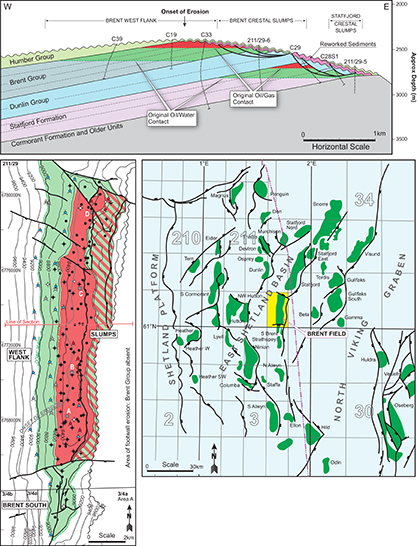
Figure 14.
Diagram depicting the main structural elements and fields of the Brent province in the East Shetland Basin. West-east seismic line and plan view images of the Brent field contrasting the relative structural simplicity and stratigraphic truncation that characterizes its western flank with the complexity of footwall areas (Bowen, 1975, 1992; Struijk and Green, 1992; Taylor et al., 2004). Rotation and subaerial exposure adjacent to the major structure-defining normal fault to the east led to the development of a footwall-mounted fault-scarp degradation complexes consisting of fault-bound compartments and slumps (Taylor et al., 2004). Understanding of the latter was a significant challenge but an important one to resolve during the latter stages of production when proportionately more oil lay in the field’s attic. The advances in deviated drilling technology and seismic imaging meant that many of these areas were drained successfully adding important reserves to the fields.
Figure 14. Diagram depicting the main structural elements and fields of the Brent province in the East Shetland Basin. West-east seismic line and plan view images of the Brent field contrasting the relative structural simplicity and stratigraphic truncation that characterizes its western flank with the complexity of footwall areas (Bowen, 1975, 1992; Struijk and Green, 1992; Taylor et al., 2004). Rotation and subaerial exposure adjacent to the major structure-defining normal fault to the east led to the development of a footwall-mounted fault-scarp degradation complexes consisting of fault-bound compartments and slumps (Taylor et al., 2004). Understanding of the latter was a significant challenge but an important one to resolve during the latter stages of production when proportionately more oil lay in the field’s attic. The advances in deviated drilling technology and seismic imaging meant that many of these areas were drained successfully adding important reserves to the fields.