The AAPG/Datapages Combined Publications Database
AAPG Bulletin
Full Text
![]() Click to view page images in PDF format.
Click to view page images in PDF format.
AAPG Bulletin, V.
DOI: 10.1306/07132120084
Geological controls on petroleum plays and future opportunities in the North Sea Rift Super Basin
John R. Underhill1 and Nick Richardson2
1Centre for Exploration Geoscience, Institute of GeoEnergy Engineering, School of Energy, Geoscience, Infrastructure & Society, Heriot-Watt University, Edinburgh Campus, Riccarton, Edinburgh, United Kingdom; present address: Interdisciplinary Centre for Energy Transition, School of Geosciences, Meston Building, King’s College, Aberdeen University, Aberdeen, United Kingdom; [email protected]
2Oil & Gas Authority (OGA), Aberdeen, United Kingdom; [email protected]
ABSTRACT
The North Sea Super Basin is a trilete rift system located in the maritime waters of the United Kingdom, Norway, Denmark, Germany, and the Netherlands. Created after a phase of regional thermal doming in the Middle Jurassic, the rift basin consists of the Viking Graben, Central Graben, and Moray Firth Basin and their surrounding platform areas. Synrift extensional activity occurred during the Upper Jurassic followed by postrift thermal subsidence from the Cretaceous to the present day. The basin’s main Upper Jurassic (Humber or Viking Group) source rocks were deposited contemporaneously with rifting. Their subsequent subsidence history led to progressive maturation, initially focused in the grabens, but becoming ever more extensive with time. Maximum burial of the Upper Jurassic occurs at the present day leading to the efficient charge of a diverse array of overlapping plays. The only exception occurs in western parts of the Moray Firth rift arm, where Cenozoic uplift arrested the maturation of Upper Jurassic source intervals. However, Middle Jurassic (paralic), Lower Jurassic (marine), and Middle Devonian (continental) lacustrine source rocks reached maturity there too and created an additional local petroleum system. The North Sea’s reservoirs span the entire geological column and all of the post-, syn- and prerift megasequences. Despite being stratigraphically older, the Devonian–Middle Jurassic (prerift) reservoirs receive charge because the Upper Jurassic source rocks lie structurally deeper in the graben.
Since oil first flowed from the North Sea in 1975, 15 fields have been found to contain more than 1 billion BOE in recoverable reserves and more than 95 billion BOE have been extracted to date, making it one of the most significant petroleum basins in the world. Production from the area allowed the United Kingdom and Norway to exceed their energy needs and become net exporters for two decades. However, rates have declined significantly, and the rift system is now considered to be a mature petroleum province. Despite the smaller volumes and reduced size of accumulations, companies continue to seek, identify, and drill prospects that will extend the life of the basin. The continued exploration activity and field development has led to an estimate that approximately 10–20 billion bbl of oil equivalent remains to be developed. With many fields now depleted, efforts are increasingly focused upon decommissioning and the repurposing and reemergence of the basin for an alternative (renewable) low-carbon future that faces the energy transition and challenge to meet stringent net zero emission targets. These include the evaluation of safe subsurface storage sites for carbon dioxide, hydrogen, methane, and compressed air, and the development of new energy integration projects such as coupled blue hydrogen, green hydrogen, platform electrification using wind turbines, geothermal energy, gas-to-wire, and geothermal initiatives. The latter will all become increasingly important as the basin addresses the energy transition and challenge to meet net zero emission targets.
INTRODUCTION AND CONTEXT
Super basins are defined as those sedimentary basins from which more than 5 billion BOE have been produced and at least 5 billion BOE of reserves and undeveloped resources have also been identified (Sternbach, 2018, 2020). As such, they host the most prolific and efficient petroleum systems in the world. Several prospective sedimentary basins occur in the northwestern European continental shelf, yet only two meet the criteria that allows them to be classified as global super basins. One is the Anglo-Polish trough (also referred to as the Southern Permian Basin), which stretches from eastern England to Poland via the Netherlands, Germany, and Denmark (Figure 1). The other is the North Sea rift system, which largely straddles the international borders of the United Kingdom, Norway, and Denmark (Figure 1). The hydrocarbon volumes extracted from both of these super basins places them in the top 25 productive basins of all time.
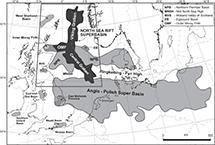 Figure 1. Map showing the geographical extent of the main petroleum systems of the northwestern European continental shelf and the position of the North Sea Rift Super Basin in relation to the Anglo-Polish Super Basin (or Southern Permian Basin), its Northern Permian Basin counterpart, and other significant petroleum systems such as the West Shetlands, East Irish Sea, Wessex, and Weald Basins. The North Sea rift’s petroleum system encompasses the three rift arms (Viking Graben, Central Graben and Moray Firth) as well as the Egersund Basin and Inner Moray Firth outliers.
The aim of this paper is to describe the key factors that control and underpin the exploration history, petroleum systems, and volumes that lead to the North Sea rift being classified as a global super basin. The basin’s geological success is founded on the presence of one major and several minor source rocks (Cornford, 1998), multiple reservoir play levels, occurrence of excellent regional top, and intraformational seals. The oil and gas traps display a variety of structural styles, an ideal timing of maturation after trap formation, and the occurrence of highly efficient migration pathways. The result of the favorable disposition of the geological elements has led to successful development of clastic and carbonate reservoirs, the stratigraphy for which spans the Phanerozoic (Figure 2) throughout the rift system (Figure 3).
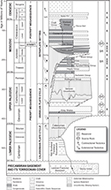 Figure 2. Stratigraphic column depicting the main plate cycles, unconformity-bound tectono-stratigraphic (pre-, syn-, and postrift) megasequences, the occurrence of key source rock intervals, and the predominant reservoir plays in the basin. The prospective sedimentary reservoirs range in age from the Devonian to the Eocene. Although they are predominantly clastic depositional systems, upper Permian (Zechstein Group) and Upper Cretaceous (Chalk Group) carbonates also make a contribution to production in the central North Sea. E = Eocene; O = Oligocene; P = Paleocene.
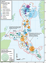 Figure 3. The geographical extent of the distribution of fields classified by reservoir age and size with the field volumes illustrated by relative diameter of the circles. Fifteen of the rift’s fields contain recoverable reserves of more than 1 billion BOE (BBOE), and a further 10 have recoverable reserves in excess of 700 million BOE (MMBOE). Seven of the largest fields sit in the Norwegian Sector: Troll, which contains more than 11 BBOE, Ekofisk (4.6 billion [B] barrels), Statfjord (4.4B), Oseberg (3.4B), Johan Sverdrup (2.7B), Gullfaks (2.5B), and Snorre (2B). The other three lie in the United Kingdom sector: Forties (2.9M), Brent (2.7B), and Ninian (1.3B). As well as showing where the largest fields reside, the diagram serves to demonstrate that the fields hosting Middle Jurassic reservoirs dominate the North Viking Graben and Paleocene ones are the most significant in the Central Graben. The mapped extent of the Upper Jurassic Humber Group sourced petroleum system and the Devonian-sourced “outliers” in the Inner Moray Firth rift arm and Egersund Basin are highlighted. 2P = proven plus probable reserves.
As well as its immediate impact for the economies of the United Kingdom, Norway, and Denmark, exploration for and production from the North Sea has been a major stimulus for understanding the generic development of rift systems. The knowledge obtained through seismic acquisition and drilling activity in the super basin has been deployed to great effect in other extensional settings (Davison and Underhill, 2012), and several seminal papers resulted from the studies in the North Sea that have had global applicability to rift systems. Examples include those with impact on sedimentary basin evolution (e.g., McKenzie, 1978), subsidence and compaction trends (Sclater and Christie, 1980; White and Latin, 1993; Nadin et al., 1995), seismic and sequence stratigraphy (e.g., Vail et al. 1984; Underhill 1991a, b; Galloway et al., 1993; Partington et al., 1993a, b; Rattey and Hayward, 1993), plume-related volcanism and rifting (Underhill and Partington, 1993, 1994), salt tectonics (halokinesis; Penge et al., 1993; Davison et al., 2000a, b), clastic depositional systems (Johnson and Stewart, 1985), and injectites (Hurst et al., 2005), among others. The stratigraphy, geological evolution and exploration history of the North Sea has been comprehensively documented in a series of landmark publications (Woodland 1975; Illing and Hobson 1981; Rønnevik et al., 1983; Brooks and Glennie 1987; Abbots, 1991; Hardman, 1992; Parker 1993; Steel et al., 1995; Glennie, 1998a; Fleet and Boldy 1999; Evans et al., 2003; Gluyas and Hitchens, 2003; Doré and Vining, 2005; Vining and Pickering, 2010; Bowman and Levell, 2018; Goffey and Gluyas, 2020), each of which contain an extensive set of references.
Significant advances in technology through enhanced seismic acquisition, processing, and imaging together with improved drilling methods have contributed to an ever-increasing understanding of the subsurface geology. The progressive sharpening of geological concepts resulting from the research in the North Sea combined with technological advances and the construction of robust engineering networks of fields and pipeline infrastructure provided the platform upon which to explore and develop the super basin. The very same solid technical foundation, engineering, and drilling technology and infrastructure now offers new opportunities to extend its life and major efforts are not only going in to near-field exploration (NFE) or infrastructure-led exploration but also toward repurposing the basin to face the low-carbon energy transition in an effort to meet net zero emissions targets.
Finally, having largely stable and attractive fiscal (tax) regimes (Brzozowska et al. 2003), regular licensing rounds, a relatively rapid turnover of fallow acreage leasehold, a governmental demand for indigenous oil and gas to guarantee secure supply, and the public release of data have all helped to promote its exploration, appraisal, development, and production history (Brennand, 1984; Brennand et al., 1990).
EARLY HISTORY OF LICENSING AND EXPLORATION
There had been a long history of exploration success in several onshore areas of northwestern Europe prior to the development of the North Sea. Over the course of the twentieth century, petroleum systems were well established in the East Midlands, Midland Valley of Scotland, and Lancashire in the United Kingdom (Figure 1) (Lees and Cox, 1937; Lees and Taitt, 1945) as well as parts of Germany and the Netherlands. The latter provided the catalyst for offshore exploration in the North Sea with the drilling of the Slochteren-1 well in 1959 and Ten Boer-1 well 4 yr later that discovered and appraised the giant Groningen gas field in northern Holland (Stauble and Milnus, 1970; de Jager and Visser, 2017). Its discovery renewed speculation that oil and gas reserves might be present in offshore basins beneath the North Sea.
Despite new-found interest in moving exploration activity offshore, there was no practical way of doing so because the prerequisite legislation to govern licensing was not in place and only a few isolated wells were drilled in undisputed nearshore “territorial” waters that extended 5–20 km from the coast. Control over deeper waters that extended to the edge of the continental shelf, defined by the 200-m isobath, was contested by nation states. Because the North Sea lay in shallower depths, the countries with a coastal boundary followed rules laid down by the 1958 Geneva Convention, whereby equidistance outward from the nearest opposed coastline defined the median line. Significantly, that agreement meant that seismic surveys could be acquired prior to licensing arrangements being in place and the first offshore survey was shot in Danish waters in 1963 using 50-lb dynamite charges, and some 14,000 km had already been acquired by 1967 (Childs and Reed, 1975).
The Continental Shelf Act (Legislation.gov.uk, 1964) was passed by the United Kingdom Parliament in 1964 and set out the rules for offshore licensing at the time. Similar laws were ratified in Denmark and Germany in the same year, in Norway in 1965, and finally, in the Netherlands in 1968. Although there was consistency in defining quadrants by 1° of latitude and 1° of longitude, there were important differences in the shape and size of individual license blocks. The United Kingdom subdivided their quadrants into 30 blocks of approximately 200 km2; Norway decided to have larger subdivisions and defined 12 blocks in each quadrant, each of which are approximately 500 km2. Denmark settled upon 32 blocks per quadrant, and the Netherlands and Germany both went for 18.
Having agreed the size of license blocks and a procedure for exploration and exploitation in offshore waters, the United Kingdom led the way by launching the First Seaward Licensing Round on September 17, 1964. The outcome of the applications saw 53 licenses consisting of 394 blocks awarded to 51 companies that formed part of 22 joint venture consortia. The first Norwegian licensing round for offshore exploration was held in 1965 and included 278 of the 346 blocks available for award. The first offshore licensing round in the Netherlands was held in 1968. By way of contrast, in Denmark, the first and sole initial concession was granted to A. P. Møller-Maersk back in 1962 and covered the entire offshore area. That was subsequently amended in 1981 and paved the way for the first Danish offshore licensing round to take place in 1984. No formal licensing rounds have been held in offshore waters of Germany and individuals, corporate bodies or commercial partnerships have been able to apply at any time.
The first well drilled on United Kingdom licensed acreage was Amoseas’ 38/29-1 well, which was spudded in the Dogger Bank area on December 26, 1964. Drilled some 200 km east of the English coast, in what is now recognized as the mid North Sea high (i.e., outwith the North Sea rift system as it would now be defined), it was plugged and abandoned as a dry hole. Twelve other wells followed, all of which were drilled farther south in the shallow waters of the southern North Sea. The fourth well, British Petroleum’s (BP) 48/6-1, discovered gas in Permian (Rotliegende) sandstones (in what was to become the West Sole field) in 1965, thus paving the way for the offshore part of the Anglo-Polish Basin to be opened up. It was soon followed by gas discoveries by Conoco (Viking), Shell and Amoco (Leman and Indefatigable), and Phillips Petroleum (Ann and Deborah). Arco made a further discovery in Triassic sandstones in 1966 (Hewett field; Cumming and Wyndham, 1975).
Exploration moved north into the central North Sea and led to the first oil discoveries being made in the North Sea rift system itself in Danish waters at Anne (1966), Roar and Tyra (1968), and Arne (1969). In Norway, early discoveries made at Valhall (1967) and Cod (1968) were followed by success at the giant Ekofisk field by Phillips Petroleum in December 1969. The latter discovered oil in lower Cenozoic (Danian) and Upper Cretaceous carbonate reservoirs contained in a broad, open anticline created by salt movement (halokinesis) of upper Permian (Zechstein Group) evaporites.
The first oil to be discovered in the United Kingdom sector came when Amoco drilled Paleocene clastics at the Montrose field and BP followed suit by discovering the giant Forties field in the same reservoir interval in October 1970. In the same month, Shell discovered oil in upper Paleozoic (Permian) reservoirs at Auk field, and the following year, Hamilton did likewise at the Argyll field (Pennington, 1975). Because it was oil rather than gas that was discovered, all of these discoveries proved to be the game changer that really triggered the appetite for further frontier exploration in deeper, less hospitable waters of the northern North Sea. So, with an active oil-prone petroleum system proven and multiple levels to explore, the race to acquire acreage in the North Sea gathered pace and subsequent licensing rounds were keenly contested. As a consequence, licenses were offered over large swaths of the United Kingdom Continental Shelf (UKCS).
Although very few of the blocks in the northern North Sea initially attracted bids, one exception was the Shell/Esso joint venture, who bid for, and were awarded, block 211/29 in the third Licensing Round in 1970, with a commitment to acquire seismic data and drill a well. Early explorers had little understanding of the stratigraphy that they might encounter. However, rather than this being a deterrent, there was genuine excitement and much speculation in the Shell/Esso joint venture as to what the drill bit might encounter especially in a seismically opaque package lying beneath a prominent unconformity (originally termed the “X horizon” by operators in the early years of exploration). Some interpreters suggested that the surface represented a nonconformity and predicted that wells would encounter nonprospective igneous or metamorphic basement below similar to the Scottish Highlands and Norway either side of the North Sea (Bowen, 1975). Those of a more optimistic mindset drew encouragement from the fact that the initial seismic data showed some dipping reflectors beneath the unconformity (Bowen, 1975, 1992). They also drew attention to best-fit restorations of the Atlantic (e.g., Bullard et al., 1965), which placed the area closer to rift systems of East Greenland (Haller, 1971), where many of the stratigraphic, sedimentary, and structural components of a prospective petroleum system were recognized (Birkelund and Perch-Nielsen, 1969; Surlyk et al., 1971, 1974; Surlyk and Birkelund, 1972; Surlyk, 1978).
Drilled in 1971, at a location some 500 km north-northeast of Aberdeen, the 211/29-1 well was at the time the most northerly offshore exploration well. Its target was an elongate four-way closure of the so-called X horizon defined using a sparse grid of two-dimensional seismic data (Bowen, 1975). Its outcome was to confound the skeptics, however, since it proved that major oil-bearing Middle Jurassic clastic reservoirs lay beneath the “X,” which was rechristened and thereafter referred to as the Base Cretaceous unconformity. With the fourth Licensing Round imminent, the well was quickly completed in the Lower Jurassic and kept on a very strict tight-hole status so as not to alert competitor companies to the significance of the find. The subsequent appraisal and testing only occurred in 211/29-2, which not only found a 545 ft oil column but also located a deeper Triassic–Lower Jurassic (Statfjord Formation) reservoir, albeit water-bearing at this location. The latter was to add pay at Brent and prove to be a major reservoir in other fields across the province including the Statfjord field from which it took its name.
The Brent discovery stimulated exploration activity for similar targets in the East Shetland Basin on the western flank of the North Viking Graben during the aforementioned fourth United Kingdom offshore licensing round. That round remains the only one in which financial bids were required and opened in public. Such was Shell/Esso’s desire for more prime acreage in the same area that they tabled a bid of £21 million to secure block 211/21, which subsequently proved to be some £13 million higher than the next nearest bid for it. Encouraged by the success seen in the United Kingdom northern North Sea, the Norwegian authorities made a special award of blocks 33/9 and 33/12 in the area in August 1973. The subsequent drilling campaign led to the discovery of numerous giant fields either side of, and in some cases straddling, the border between the United Kingdom and Norway in what became known as the “Brent province.” These included the discovery of Cormorant (1972), Thistle (1972), Ninian (1974), Statfjord (1974), Snorre (1974), Heather (1976), and Gulfaks (1978) in the northern North Sea. Major discoveries were also made during the same period at Beryl (1972) in the South Viking Graben, and Beatrice (1976) in the Inner Moray Firth.
Despite being found after the initial oil discoveries in the province, the honor of being the first North Sea oil producer belongs to the Permian (Rotliegende and Zechstein Group) reservoirs of Argyll field, with the first oil on stream via a tanker in the Thames Estuary in June 1975. Development of Paleogene reservoirs of the central North Sea occurred in parallel to Argyll though and soon led to oil flowing through the Forties Pipeline System to Cruden Bay and Hound Point near Edinburgh later the same year. Oil from the Brent province came on stream on November 25, 1978, through the Sullom Voe terminal on the Shetland Islands.
GEOLOGICAL EVOLUTION
The exploration activity that has occurred over the past six decades has provided a wealth of data upon which to extend geological observations and interpretations from onshore outcrops to the subsurface of the North Sea (e.g., Woollam and Riding, 1983; Vollset and Dore, 1984; Partington et al., 1993a; Hesketh and Underhill, 2002), and the definition of new lithostratigraphic units in the offshore (e.g., Rhys, 1974; Deegan and Skull, 1977 etc.). Conversely, the integration of the seismic, well, and core data acquired in the pursuit of petroleum reserves in the buried rift has added massive value to the understanding of the tectonic, stratigraphic, and sedimentological development and evolution of northwestern Europe. The rich database also provides the foundation upon which to evaluate sites for safe subsurface storage of carbon dioxide (CO2), hydrogen, and methane gas as the basin evolves to face a low-carbon future.
Integration of the subsurface data from onshore and offshore areas with field studies has demonstrated that the North Sea domain was preceded by and sited upon two complete Phanerozoic (Caledonian and Variscan) plate tectonic cycles (Figure 2), both of which involved the construction (rift-drift), subduction, accretion of major (Iapetus and Rheic) oceans and their destruction through continental collision and mountain building (Ziegler, 1982, 1990a; Glennie and Underhill 1998; Underhill, 2003).
Since the end of the (Permian–Carboniferous) Variscan orogeny, the area has lain in an intraplate setting and, hence, only been affected by intraplate processes that have primarily taken the form of extension and contraction (structural inversion) caused by far-field (intraplate) stresses driven by Alpine (Tethyan) and Atlantic deformation. The early Cenozoic could arguably be considered an exception to this general intraplate setting, however, since the stratigraphic development of the British Isles was more closely associated with the opening of the north Atlantic Ocean that propagated north at that time. Sea-floor spreading was initiated in the early Eocene, leading to creation of oceanic crust, and continental drift between Greenland and northwestern Europe, a process that continues to the present day. The main tectonic consequences largely take the form of diffuse extension and structural inversion caused by the compressional reactivation of former normal faults and deformation caused by thermal effects associated with the generation and decay of mantle plumes under the North Sea and in Iceland.
The Caledonian Plate Cycle
The early Paleozoic history of the British Isles and North Sea areas was dominated by the late Cambrian–late Silurian, Athollian (former Grampian), and Caledonian orogenies, which are the tectonic products of continent-ocean, continent-continent collision, and major transpression (Glennie and Underhill, 1998). Prior to these events, the North Sea area comprised three different continental fragments (Avalonia, Baltica, and Laurentia) that were widely separated by the southwest-northeast–striking Iapetus ocean and the northwest-southeast–striking Tornquist Sea. Closure of the Iapetus ocean is thought to have been diachronous and achieved by both northwest- and southeast-directed subduction (Phillips et al., 1976) and continental suturing and resulted in the creation of the Laurussia mega-continent.
The collisional processes led to the formation of a major (Caledonian) mountain range that stretched from the southern United States to eastern Canada (Appalachians) through northern Britain to the northern end of the Greenland-Scandinavia craton. The line of closure is marked by a northeast-southwest-striking suture that can be traced from the Shannon Estuary in western Ireland through Northern Ireland, beneath the Solway Firth and Northumberland trough to the northeastern coast of England. The so-called “Iapetus suture” passes out into the North Sea, to meet its Tornquist counterpart at a triple junction in the central North Sea before reappearing in Norway. Each plate is characterized by different crustal rheology, something that is readily apparent from seismic tomography (Crowder et al., 2020). Reactivation of the structural trends was to be a significant factor in later deformation. The final stages of Caledonian collision were accompanied by the intrusion of Early Devonian granites that subsequently played an important role in creating extensional fault blocks during the periods of Carboniferous and Late Jurassic extension.
The Variscan Plate Cycle
The Variscan plate cycle lasted from the Devonian to the late Carboniferous. It began with a phase of Devonian rifting initially driven by intramontane collapse of the Caledonian Mountains and the creation of the Rheic ocean to the south. The structural configuration of the British area appears to have been partially controlled by the occurrence and reactivation of Caledonian and other basement lineaments together with the presence of the aforementioned granitic plutons (Underhill et al., 1988; Corfield et al., 1996). An east-west–striking passive continental margin developed across much of southern parts of England and Wales that consisted of south-dipping normal fault systems (Glennie and Underhill, 1998). To the north, a series of intracontinental extensional half graben characterized the East Midlands and northern England. Where the basement lineaments or the margins of Caledonian granitic intrusions were not favorably oriented to take up dip-slip extensional displacement, strike- or oblique-slip deformation resulted across northern Britain (Underhill et al., 1988, 2008; Corfield et al., 1996).
Continental sequences dominate the synrift depocenters of northern Britain (e.g., the Midland Valley of Scotland; Underhill et al., 2008), reflecting their proximity to the Caledonian Mountains from which they were derived. More southerly depocenters are characterized by marine sequences, with those of northern England dominated by fine-grained clastics (e.g., the Bowland and Hodder Shales) that form source rocks that charge petroleum systems in the East Irish Sea Basin, East Midlands, and southern North Sea (Besly, 2018). The same units also create shale gas targets (e.g., in Lancashire, Yorkshire, and Nottinghamshire). Farther south, the lower Carboniferous depocenters are dominated by carbonates that line the northern margin of the Rheic ocean and pass southward into basinal mudstones of Devon and Cornwall (Ziegler, 1982, 1990a, b).
The Variscan orogeny marked the subduction, accretion, and eventual closure of the Rheic ocean and the creation of the supercontinent Pangaea. It led to the former passive continental margin being telescoped to form a mountain belt and a northward-tapering, flexural foreland (foredeep) basin, the depocenter for which stretched from southwestern Ireland through southern Wales, to Kent, the Ardennes of Belgium and beyond. The effects of the contractional deformation and associated metamorphism place effective limits on the southern extent of Devonian and Carboniferous play fairways leading to the exploration potential being severely challenged and extremely limited in southwestern England and the Western Approaches.
Farther north, the intracratonic extensional and strike-slip basins of central and northern parts of the United Kingdom, such as the Midland Valley of Scotland, Bowland Basin, Widmerpool Gulf, Edale trough, and Northumberland Basin, accommodated Variscan deformation through the contractional reactivation (structural inversion) of the former extensional faults and regional uplift (Underhill et al., 1988, 2008; Fraser and Gawthorpe, 1990; Underhill and Brodie, 1993; Corfield et al., 1996; Anderson and Underhill, 2020). Footwall closures, inversion structures, intrabasinal folds, and stratigraphic truncation that resulted from the extensional and subsequent contractional events contribute to the formation of prospective traps in the Carboniferous play (e.g., in the East Midlands and southern North Sea; Fraser and Gawthorpe, 1990; Corfield et al., 1996).
Intraplate Deformation
The early Permian extension led to extensive, rift-related volcanism and igneous intrusion across northwestern Europe in Norway (the Oslo graben), Poland, Germany, the Netherlands, the Midland Valley of Scotland, the occurrence of the Whin Sill igneous complex across northeastern England, and volcaniclastic sediments in Devon (the Exeter Volcanic Series). Two, elongate, east-west–striking intracratonic basins were created, separated by the mid North Sea high (Glennie, 1998b; Ziegler 1982, 1990a, b; Brackenridge et al., 2020). Commonly referred to as the Northern and Southern Permian (or Anglo-Polish) Basins, their development initially hosted an extensive succession of aeolian and fluvial red beds belonging to the Rotliegende Group that gave way to a succession of carbonate-evaporite cycles ascribed to the Zechstein Group. Although the latter forms an extensive top seal for Rotliegende reservoirs in the area, basin-margin Zechstein Group carbonates also form reservoirs locally in the North Sea rift, as exemplified by production at Auk and Argyll in the Central Graben (Brennand and Van Veen, 1975; Trewin et al., 2004).
Extensional activity was renewed in the Triassic, with the development of numerous half-graben depocenters in areas such as the East Irish Sea Basin, Wessex Basin, Worcester graben, Cheshire Basin, and Vale of Eden. The United Kingdom basins form part of a wider pattern of distributed rifting that extends across the North American seaboard (e.g., Newark Basin) and Norway (e.g., the Stord and Egersund Basins, where there was accompanying igneous activity). The Triassic Period of extensional basin development was initially dominated by postrift thermal subsidence, which was accompanied by the development of widespread salinas and mudflats ascribed to the Mercia Mudstone Group onshore and the equivalent units that are ascribed to the Haisborough Group offshore (e.g., Rot, Muschelkalk, and Keuper halites and mudstones).
Continued subsidence led to marine waters returning to the northwestern European continental interior in the Lower Jurassic (Hettangian) for the first time since the upper Carboniferous, a period of more than 115 m.y. The transgression was more pronounced in areas where extension and growth faulting occurred such as in the Cleveland, Weald, and Wessex Basins and on the Ninian-Hutton fault, which controlled thickness and facies distribution of the Statfjord and Dunlin Formations in the East Shetland Basin. Data from basins in Denmark and offshore Britain suggest that marine incursion came from the south, with gradual onlap of marine strata to the north. This regional pattern supports the interpretation of a southerly dipping paleoslope toward a shoreline that was located up to 350 km southward of proximal fluvial environments in the North Viking Graben (Ryseth, 2001).
The period of Triassic–Early Jurassic postrift subsidence and transgression was terminated by a phase of latest Early Jurassic–Middle Jurassic doming, which reset the whole depositional system and controlled subsequent basin rifting and thermal subsidence history (Ziegler, 1982, 1990a, b, 1992; Underhill and Partington, 1993, 1994). Accompanied by igneous activity (the Rattray Volcanic Series; Dixon et al. 1981; Quirie et al., 2019), the uplift was centered on the central North Sea and is interpreted to have resulted from the development of a warm, diffuse, and transient plume head that created “the North Sea dome” (Figure 4) (Underhill and Partington, 1993, 1994). Ammonite faunas demonstrate that the dome created a barrier between Arctic and Tethyan (sub-Mediterranean) waters, which complicated regional stratigraphic correlations (Morton et al., 2020). The North Sea dome also created a quaquaversal pattern of drainage was established with the progressive outward progradation of significant volumes of fluvio-deltaic sediments derived from erosion of central areas (Figure 4). The resultant major deltaic wedge created the main Brent Group reservoir play fairway in the East Shetland Basin of the northern North Sea (Budding and Inglin, 1981; Eynon, 1981; Graue et al., 1987; Helland-Hansen et al., 1992) on the northern flank of the North Sea dome (Figure 4) (Underhill and Partington, 1993, 1994).
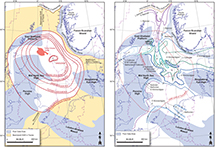 Figure 4. Diagram showing the extent of the Middle Jurassic North Sea dome and record of subsequent transgression along the nascent rift arms (modified after Underhill and Partington, 1993, 1994). E = Early; L = Late; M = Middle.
The initial deflation of the dome occurred in the Middle to Upper Jurassic (Bathonian–Oxfordian) following igneous and volcanic activity (Underhill and Partington, 1993, 1994). Its collapse led to the progressive yet punctuated (subseismic) onlap along the nascent rift arms prior to more substantive (seismic-scale) normal faulting (Figure 4) (Underhill and Partington, 1993, 1994), the effect of which was to create a triple junction intersection at the center of the thermal dome. The trilete rift system’s formation, deflation, and collapse not only drove Late Jurassic to earliest Cretaceous extensional tectonics but also led to deep-water sedimentation along the graben axes (Underhill and Partington, 1993, 1994).
Seismic interpretations ably demonstrate that the Viking Graben, Central Graben, and Moray Firth were all characterized internally by extensional fault-block rotations leading to the formation of major three-way fault-bound structural traps (Beach, 1984; Badley et al., 1988; Yielding, 1990; Underhill, 1991b; Yielding et al., 1992; Underhill, 1998, 2003). The clear inference taken from this is that each rift arm was dominated by dip-slip extension (Davies et al., 2001), meaning that there is no need to accommodate the deformation in a single regional slip vector (cf. Roberts et al., 1990; Bartholomew et al., 1993; Erratt et al., 1999), thus ruling out the need to appeal to major strike- or oblique-slip movement in two of the three rift arms.
The occurrence and strike of the Permian–Triassic faults had long been supposed to have contributed to Upper Jurassic fault activity through reactivation. However, improvement in seismic technologies and imaging have revealed that the two sets of extensional faults commonly have a different strike and dip polarity, implying that they were largely independent of one another (Tomasso et al., 2008) and only a few Upper Jurassic faults can be attributed to the reactivation of Permian–Triassic faults. As a result, the trilete North Sea rift is now thought to be largely independent from and superimposed on older structures with the thickest Triassic depocenters (e.g., the Stord Basin) occurring to the east under the Horda platform (Tomasso et al., 2008).
The phase of Late Jurassic extensional basin development was followed by a phase of Cretaceous–Cenozoic postrift thermal subsidence leading to the development of a saucer-shaped basin superimposed on the three rift arms (Figure 5) to create a typical “steer’s horn” cross-sectional basin geometry (Figure 6). The synrift-postrift boundary is commonly taken to be marked by the Base Cretaceous unconformity. Although it is a very prominent seismic horizon event, its name was ascribed as a consequence of the early wells, and more detailed studies now demonstrate that it does not coincide with the Jurassic–Cretaceous boundary and is not even an unconformity in the basin depocenters. Instead, it represents a condensed stratigraphic interval in the rift arms and the erosional unconformity is confined to footwall highs and the basin margins (Rawson and Riley, 1982).
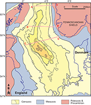 Figure 5. Depth to Base Cenozoic showing the elongate nature of the North Sea Basin’s postrift fill. The lines of section correspond to the cross sections shown in Figure 6.
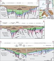 Figure 6. Three regional west-east–striking (dip) cross sections across the North Sea rift system illustrate the basin’s three main (pre-, syn-, and postrift) tectono-stratigraphic megasequences. The main rift-related platform-graben structural domains such as the Shetland platform, the East Shetland Basin, the Viking Graben, the Horda platform and Norwegian shelf, Utsira high, Stord Basin, Western platform, Western trough, Forties Montrose high, Eastern trough, Jaeren high and Egersund Basin are all highlighted. The cross sections serve to illustrate how migration out from the stratigraphically younger, but structurally deeper Upper Jurassic (synrift) source rock can fill-and-spill into rotational fault blocks housing prerift reservoirs, their synrift counterparts in half-graben hanging-wall depocenters and into reservoirs belonging to the typical “steer’s horn” postrift section too.
Source rocks belonging to the Upper Jurassic, Kimmeridge Clay, and Heather Formations of the Humber, Viking, and Vestland Groups were buried sufficiently deeply to mature during the postrift phase of subsidence (Cornford, 1998). That led, in turn, to petroleum migration out from the deepest parts of the basin to charge reservoirs contained within sealed traps through updip fill-and-spill that has made the North Sea Basin the prolific oil and gas province that it has become (Goff, 1983; Burley, 1993). Additional source rock potential of Middle Devonian and Lower and Middle Jurassic occurs in the Inner Moray Firth, where it cosourced waxy crude found in the Beatrice field and its satellites.
The development of the Atlantic Ocean had a profound effect on the northwestern European shelf in general and the North Sea in particular. Cretaceous extension linked to the northeastward propagation and eventual onset of sea-floor spreading in the north Atlantic Ocean in the early Eocene led to a series of northeast-southwest–striking sedimentary basins being formed, the most notable of which is the Faroe-Shetland Basin (Lamers and Carmichael, 1999). Although that basin is also prospective and contains the largest single oil pool in the United Kingdom in the 7 billion bbl Clair field (Coney et al., 1993; Johnston et al., 1995; Witt et al., 2010), it has a distinctive structural history and its total volumes fall well short of those in the North Sea.
The Magnus field represents an example of a structure lying in the North Sea Rift Super Basin that resulted from the postdepositional footwall uplift of Upper Jurassic deep-water clastic reservoirs driven by Cretaceous extension. The far-field effects of Atlantic rifting also drove structural inversion during the Lower Cretaceous and the formation of anticlinal traps during the Lower Cretaceous including those containing prospective Upper Jurassic (synrift) clastics of the Brae trend in the South Viking Graben.
The subsequent development of the Iceland hotspot, the northward propagation of the North Atlantic, and instigation of sea-floor spreading between northwestern Europe and Greenland have all impacted the North Sea. The inception of the mantle plume led to the creation of the North Atlantic Large Igneous Province (Mussett et al., 1988) and significant igneous underplating of the continental crust. Underplating led to Cenozoic exhumation of large parts of the British Isles and punctuation of the postrift subsidence by periods of uplift in western areas (Nadin et al., 1995) that is particularly well documented in the western part of the North Sea rift (the Inner Moray Firth; Hillis et al., 1994; Thomson and Underhill, 1993), where progressively older subcrop patterns occur (Guariguata-Rojas and Underhill, 2017). The associated fault reactivation also added to the structural complexity and was largely detrimental to petroleum prospectivity (Argent et al., 2000) and affects the carbon storage potential of saline aquifers in the area (Guariguata-Rojas and Underhill, 2017).
The creation of oceanic crust between Greenland and northwestern Europe during the Eocene, combined with the effects of Tethyan (Alpine and Pyreneean) collision (Ziegler, 1987), has led to additional phases of compressional on the Atlantic margin (e.g., Tuitt et al., 2010) and in the neighboring plate interiors thereafter. Numerous Mesozoic Basins experienced basin inversion with the formation of major anticlines as a consequence (e.g., the Wessex Basin [Colter and Harvard, 1981; Underhill and Paterson, 1998; Underhill and Stoneley, 1998], the Weald Basin [Butler and Pullan 1990], the Cleveland Basin, and in the southern North Sea [e.g., Glennie and Boegner, 1981; Ziegler, 1982, 1990a, b; Van Hoorn, 1987; Badley et al., 1989]). Although the North Sea appears to have escaped the most significant effects of the deformation, it is still characterized by punctuated subsidence, localized uplift, and fault reactivation.
The Overprint and Impact of Climate Change, Continental Drift, and Eustasy
Although the aforementioned tectonic history and consequent sedimentary responses are significant, it is important to underline that the changing pattern of crustal fragmentation and reunification occurred against a backdrop of an overall slow northward passive drift of the continents with consequences for climate. This drift took the North Sea area from south of the equator prior to the Carboniferous to its present location over halfway from the equator to the northern pole (Habicht, 1979; Smith et al., 1981). The inexorable northward-drift had a pronounced effect on fauna and on sedimentation as the area passed through successive latitudes and climatic belts.
The development of major ice sheets in the polar regions provided an additional impact on climate that modified the effects of Britain’s northerly drift. During the Phanerozoic, the Earth’s climate appears to have oscillated between a state of global warming and incubation (“greenhouse conditions”) and one of global cooling and refrigeration during which ice sheets grew and dominated the poles (“icehouse conditions”). In total, seven oscillations appear to have occurred with greenhouse conditions prevailing during the early Cambrian–Late Ordovician (570–458 Ma), early Silurian–early Carboniferous (428–333 Ma), and late Permian–early Cenozoic (258–55 Ma). Conversely, icehouse climate affected the late Proterozoic–early Phanerozoic (800–570 Ma), Late Ordovician–early Silurian (458–428 Ma), early Carboniferous–late Permian (333–258 Ma), and early Cenozoic onward (55 Ma to the present day).
Several factors also combined to control global (eustatic) sea levels through the Phanerozoic, but they were particularly responsive to changes in the size of ocean basins resulting from variations in sea-floor spreading rates, periods of continental deformation, and times of high sediment supply. In combination, climate and eustasy influenced the nature of sedimentation by determining the extent to which continental land masses were flooded, the depth of water in oceans and the degree of water circulation within and between basins. The variation in global sea level has largely mirrored the climate through time as exemplified by the glacio-eustatic cyclothems that controlled Carboniferous deposition and Late Cretaceous warming that drove global sea levels to their highest levels during the Phanerozoic with the creation of marine seaways and chalk deposition over large areas of the continental interior.
THE NORTH SEA RIFT’S PETROLEUM SYSTEM
A petroleum system encompasses all of the essential elements (source, reservoir, seal, and overburden rock) processes (trap formation, generation-migration-accumulation) and all genetically related petroleum that originated from one pod of active source rock and occurs in shows, seeps, or accumulations (Magoon and Dow, 1994). The geographical extent of a petroleum system is commonly delineated by a line within which all fields, discoveries, shows, and seeps ascribed to a specific source rock occur. The following sections describe the key elements of the North Sea rift’s petroleum system and the controls on its main reservoir play fairways. Comparison between the three rift arms highlights significant differences in the distribution of the prospective reservoirs, the controls on which we will attempt to explain.
Source Rocks
The key to the success of any petroleum province is the occurrence and maturity of an extensive, thick, and rich source rock. In the North Sea rift, pride of place goes to source horizons within the Kimmeridge Clay (Draupne) and Heather Formations, which form component parts of the Humber (Viking) Group (Barnard and Cooper, 1981; Chung et al., 1992; Cornford, 1998; Isaksen et al., 2002). Deposition of the Upper Jurassic source intervals was contemporaneous with Upper Jurassic synrift fault activity and their gentle (postrift) subsidence led to thermal maturation and petroleum migration occurring from the early Cenozoic to the present day. The effect was to set up a highly efficient petroleum system in the North Sea Basin, whereby extensional fault blocks created traps containing reservoir-seal pairs that received its petroleum charge from neighboring kitchen areas (Goff, 1983; Burley, 1993).
Although the Upper Jurassic sources dominate, there is a recognition from geochemical analyses that other sources also contribute to some fields. High total organic carbon characterizes parts of the Lower Jurassic (Dunlin and Lias Groups), Permian (Zechstein Group), Carboniferous (Dinantian and Namurian) Bowland Shale, and the Middle Devonian sedimentary sequences. Additional source intervals include the Middle Jurassic Sleipner and Brora Coal Formations, the upper Carboniferous (Pennsylvanian) Coal Measures Group, the lower Carboniferous (Mississippian) Scremerston Coal Group of northeastern England, the West Lothian Oil Shale in the Midland Valley of Scotland (Underhill et al., 2008), and the Middle Devonian lacustrine (fish-bearing) Eday Shale claystones of the Orcadian Basin. The latter makes a significant contribution in western parts of the Moray Firth rift, where Upper Jurassic source intervals are too shallow and cool to be mature, creating a petroleum system that charges the Beatrice field and its satellites (Peters et al., 1989). The occurrence of the waxy lacustrine source rocks even necessitated the construction of a dedicated refinery at Nigg to handle the waxy crude derived from the Middle Devonian source rocks.
Sedimentary Play Fairways
Paleozoic and Older Reservoirs
A variety of upper Paleozoic and older rock formations host petroleum in several parts of the North Sea (Figure 7), albeit without forming any giant fields in their own right. Their distribution is almost exclusively confined to upstanding areas lying on the graben flanks or in intrabasinal horst blocks, especially those that lie within the inner confines of the uplift resulting from the North Sea dome, which saw the removal of its Lower Jurassic sedimentary cover (Underhill and Partington, 1993, 1994). Fields that exemplify the contribution that upper Paleozoic prerift reservoirs play include the basement contribution to Emerald (Stewart and Faulkner, 1991), Devonian sandstones (e.g., in the Buchan field), Carboniferous (e.g., in the Fyfe field), upper Permian (Rotliegende Group) sandstones (and Zechstein carbonates) in the Auk field (Figure 8) (Heward, 1991), and upper Permian (Zechstein Group) carbonates that rimmed the Northern Permian Basin (e.g., in the Argyll, Claymore, and Ettrick fields; Amiri-Garroussi and Taylor, 1987).
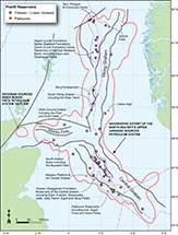 Figure 7. Distribution of Paleozoic, Triassic–Lower Jurassic (prerift) plays in the North Sea rift system. The occurrence of the fields is primarily controlled by deep-seated footwall erosion during Upper Jurassic rifting (e.g., at Snorre), the rotation and transection of Triassic rift depocenters (e.g., Alwyn North), the presence of long-lived intrabasinal highs (e.g., Buchan), and doming of the North Sea during the Middle Jurassic that removed the Lower Jurassic from much of the area. Clastic Upper Triassic and Lower Jurassic sediments belonging to the Banks Group (e.g., Statfjord Formation) and Dunlin Groups (e.g., Cook Formation) form important reservoirs in the East Shetland Basin, and the Orrin Formation forms the lower part of the prospective interval in the Beatrice field of the Inner Moray Firth.
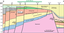 Figure 8. Geological cross section through the Auk field of the central North Sea (Brennand and Van Veen, 1975; Trewin et al., 2004). The field was among the earliest oil discoveries made and was a springboard for exploration in the North Sea rift. The structures consist of extensional tilted fault blocks that house Paleozoic reservoirs. Their charge is derived from maturation of Upper Jurassic Kimmeridge Clay Formation source rocks that lie in the adjacent graben areas. OWC = oil-water contact.
Triassic Reservoirs
Prospective Triassic reservoirs occur in the East Shetland Basin and Central Graben areas (Figure 7). They were initially discovered in heavily eroded tilted fault blocks of the northern North Sea. Examples of the play include the Snorre field, where its component parts show progressive subcrop toward the paleo-crest situated in the northeast of the field (Figure 9). The mismatch between the deepest levels of erosion and its present-day closure is thought to be a consequence of Cretaceous to present-day subsidence that led to a southerly migration in closure (Roberts et al., 2019). Other notable fields containing Triassic reservoirs in extensional fault blocks in the northern North Sea include Alwyn North, South and North Cormorant, Eider, Penguin, Strathspey, and Tern.
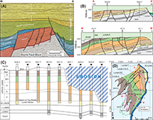 Figure 9. Montage showing the main elements of the Triassic play at Snorre in the East Shetland Basin (Modified after Hollander, 1987 and Nystuen et al., 1989). (A) West-east regional line illustrating the tilted fault-block geometry at Snorre. (B–D) The internal architecture, chronostratigraphic relationships, and resultant subcrop patterns that are consistent with the occurrence of a paleofootwall high in the north-east of the field. The fact that the present-day closure does not match the subcrop patterns reflects the fact that the locus of postdepositional subsidence migrated north during the postrift interval to set up the present-day closure in a different place than the original (synrift) footwall high was located. BCU = Base Cretaceous unconformity; L = Lower; M = Middle; TVDSS = true vertical depth subsea; U = Upper.
The discovery of the deeper potential at Alwyn North resulted from the drilling of a bold exploration well (by Lasmo) to test a deeply eroded footwall crest to an Upper Jurassic fault, in a neighboring block to the east. The discovery of a large column of condensate in the 3/10b-2 well led Total and their joint venture partners to deepen three development wells in Alwyn North to test and appraise the opportunity beneath the Brent and Statfjord reservoirs that were nearing the end of their productive life (Underhill, 2003). Having proven the existence of a large field below, Total subsequently acquired surrounding acreage to extend the play.
A notable characteristic of the Triassic sequences found on the flanks of the Viking Graben is the common occurrence of easterly-thickening packages, some of which form distinctive half-graben wedges (e.g., the Stord Basin; Tomasso et al., 2008). Interpretations on the East Shetland Basin demonstrate that the Triassic half grabens thicken in an easterly direction and are, thus, inconsistent with westward thickening expected if they were controlled by the easterly-dipping normal faults that were active during Upper Jurassic extension. Restoration for the subsequent effect of Upper Jurassic synrift activity have demonstrated that Triassic depocenters were controlled by faults with a different strike and dip from the Jurassic ones that transect them and bring the prospective Triassic reservoirs into closure. Integration of detailed facies mapping shows that their basin fill was analogous to those seen in the East African rift at the present day (Figure 10A). The sweet spot for exploration occurs where clastics that form part of the thin end of the half-graben wedge lie in the footwall of the Upper Jurassic extensional tilted fault block (Figure 10B), in positions where there is direct access to charge from the Kimmeridge Clay Formation kitchen in the adjacent hanging wall.
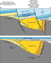 Figure 10. West-east–striking schematic section and interpretations that demonstrate the occurrence and their depositional architecture of Triassic half grabens. The diagram highlights the way in which Triassic depositional patterns have been transected by Upper Jurassic normal faults and rotated to form part of the footwall closure. Knowledge of the restored structural geometry and sedimentology are important in assessing reservoir presence and their exploration potential as demonstrated at Alwyn North and neighboring fields in the East Shetland Basin.
Major Triassic plays also exist in the central North Sea. They differ from those developed to the north largely because of the role that mobile Zechstein Group salt plays in controlling its original deposition and its impact on postdepositional structure. The two main effects the presence of the Zechstein evaporites have are in driving thin-skinned tectonics with fault detachment and through synsedimentary halokinesis activity. The latter promoted the development of thick pods of shale belonging to the Smith Bank Formation described by Erratt et al. (1999, 2010) and Helgeson (1999), the grounding of which led to compaction and bowing of overlying Buntersandstein and Skagerrak Formation (McKie et al., 2010) with the creation of fields such as Heron, Marnock, Seagull, and Skua (Figure 11). Sedimentological descriptions of the Skagerrak Formation reservoirs demonstrate that they form part of a terminal fluvial drainage systems as part of a southerly prograding wedge deposited in a semiarid climate (McKie et al., 2010). Unlike with the Smith Bank Formation that lies beneath, salt withdrawal network appears to have had little influence on primary drainage patterns in the Skaggerak, suggesting that the main controls on deposition were more regional albeit with local drainage networks controlled by and lying between Smith Bank Formation interpods.
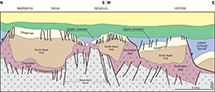 Figure 11. West-east–striking cartoon cross section across the Marnock, Seagull, and Heron fields of the central North Sea. The geology of the area is different from that of the East Shetland Basin, largely because it is located above upper Permian (Zechstein Group) evaporites of the Northern Permian Basin. Their occurrence not only controlled the formation of pods of shale ascribed to the Smith Bank Formation but also caused significant deformation of the Triassic (Skagerrak Formation) and localized deposition of younger reservoirs (e.g., Upper Jurassic, Fulmar Formation) that characterize the area.
In the Central Graben, traps preserve more complete stratigraphies beneath the late Cimmerian unconformities than their counterparts on the platform. The Culzean, Egret, Elgin, Franklin, Jade, Jasmine, Joanne, Judy, Puffin, and Shearwater fields are all examples of areas of Upper Jurassic tilted extensional fault blocks containing Skaggerak reservoirs. As with the northerly areas, the Triassic basins have been transected by later rift events. They also show a high degree of rotation resulting from thin-skinned extensional detachment in (e.g., Hodgson et al., 1992), or the mobility (halokinesis) of upper Permian, Zechstein Group evaporites that lie below.
In contrast to the grabens, higher units including the Skagerrak reservoir are rarely if ever preserved beneath the upper Cimmerian on the neighboring Western and Jaeren platforms. Instead, “grounded” pods containing only the older Smith Bank Formation are developed, leading to diminished prospectivity in all but the marginal and terraced areas as in the Gannet (C, E, and F) fields.
Upper Triassic–Lower Jurassic
The absence of sediments resulting from erosion driven by the North Sea dome means that Upper Triassic–Lower Jurassic and play fairways are more prevalent in the Viking Graben, northern North Sea, and western parts of the Moray Firth rift arm (Figure 12), where more stratigraphy is preserved beneath the mid-Cimmerian unconformity (Underhill and Partington, 1993, 1994). A rise in base level led to a transition from continental red beds in the Upper Triassic through marginal marine deposition before the establishment of fully marine conditions in the Lower Jurassic. The depositional changes are well recorded by the sedimentology and paleogeography of the (Rhaetian–Sinemurian) Statfjord Formation (Macdonald and Halland, 1993; Steel, 1993; Ryseth and Ramm, 1996; Husmo et al., 2003), which forms a significant lower reservoir in many of the fields in the East Shetland Basin. Although locally fault controlled, the formation can be subdivided into the Raude, Eriksen, and Nansen Members, which record the progressive flooding of an intracratonic (epeiric) basin (Røe and Steel, 1985; Steel, 1993).
 Figure 12. Distribution of Middle Jurassic prerift plays. The most significant fairways belong to the Brent Group hosted in rotated and eroded fault blocks of the East Shetland Basin and its Horda platform counterpart on the flanks of the Viking Graben. Exploration potential also occurs in the South Viking Graben, Central Graben, and Moray Firth in places where Middle Jurassic (Pentland Group and Brora Coal Formation) nonmarine paralic clastics were deposited. Igneous and volcanic rocks of the Rattray Volcanic Series occur in central parts of the basin and resulted from the development of a transient plume, the effects of which led to the formation of the mid Cimmerian unconformity, beneath which there is a concentric pattern of subcrop.
Other Lower Jurassic reservoirs also characterize the northern North Sea and occur encased within the younger (Hettangian-Aalenian) shale-prone Dunlin Group (Steel, 1993; Marjanac, 1995; Marjanac and Steel, 1997; Husmo et al., 2003). Derived primarily from easterly sources (Steel, 1993; Charnock et al., 2001), the Amundsen, Johansen, and Cook Sandstone Formations all contribute to the reservoir plays in Norway (e.g., in Gullfaks, Knarr, and Oseberg). However, the Cook Formation extends over the median line to make a minor contribution to production at Brent too. The preservation of Lower Jurassic sequences ascribed to the Orrin Formation made a contribution to the reservoirs contained in the Beatrice field in the Inner Moray Firth (Linsley et al., 1980; Stevens, 1991). Those on the Horda platform also make a minor contribution to reserve estimates in the Johan Sverdrup field and the Johansen Formation is also subject to investigation as a site suitable for carbon storage (the Northern Lights project).
Middle Jurassic
The Middle Jurassic Brent Group forms the main reservoir in several giant fields in the North Sea including 4 of the top 10 fields: Statfjord, Oseberg, Gulfaks, and Brent itself. Sedimentologically, the Brent Group reservoirs formed part of a major deltaic wedge that prograded north in response to runoff from, and a lowstand (or falling stage) forced regressive systems tract driven by, the doming in the central North Sea (Figure 13) (Underhill and Partington, 1993, 1994; Went et al., 2013). The clastic sedimentary sequence consists of five main lithostratigraphic units, the Broom, Rannoch, Etive, Ness, and Tarbert Formations, the first letters of which combine to make the acronym, Brent. They reflect the various stages in a regressive-transgressive (progradational-retrogradational) depositional cycle with the best reservoir facies characterizing the Etive shoreface sequences (Figure 13).
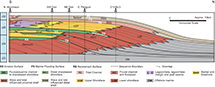 Figure 13. Cartoon depicting the depositional architecture along a north-south strike transect of the Brent delta, the formation of which is believed to be consistent with a forced regression driven by uplift associated with doming of the central North Sea and formation of the mid Cimmerian unconformity. The subsequent deflation of the dome-initiated transgression toward the south, recorded by backstepping of the Tarbert Formation and younger intervals (such as the Hugin Formation). Diagram has been redrawn after Went et al. (2013).
Although rarely seen on seismic data, evidence for thickness and facies changes in wells demonstrate a degree of synsedimentary control especially toward the latter stages of Brent Group deposition (e.g., in the upper parts of the Ness and in the Tarbert Formations (Underhill et al., 1997; Davies et al., 2000). The early extensional fault movement this implies occurred as the North Sea dome started to deflate (Underhill and Partington, 1993) and heralded the formation of the Viking Graben along which marine transgression occurred (Mitchener et al., 1992; Rattey and Hayward, 1993).
As extensional activity increased, fluvio-deltaic deposition was replaced by backstepping, shallow-marine, and deeper-water sedimentary systems belonging to the Humber Group, which form the immediate seal, and tilted fault-block structures were created. As extensional activity increased, fluvio-deltaic deposition was replaced by backstepping, shallow-marine, and deeper-water sedimentary systems belonging to the Humber Group, which form the immediate seal to the Brent Group reservoirs. Tilted fault-block structures were formed, the postdepositional rotation of which created the combined structural and stratigraphic traps for fields in the East Shetland Basin, such as Brent, Statfjord, Strathspey, and Ninian (Figure 14). The extensional activity also led to the erosion of the Brent Group over the crest of the major tilted fault block structures and additional structural complexity through the creation of fault scarp degradation complexes during Upper Jurassic, most notably on the eastern flanks of the Ninian (Underhill et al., 1997), Brent (Bowen, 1975, 1992; Struijk and Green, 1992; Taylor et al., 2004; Figure 14), Statfjord (McLeod and Underhill, 1999) and Strathspey fields (Leach, 1999).
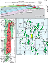 Figure 14. Diagram depicting the main structural elements and fields of the Brent province in the East Shetland Basin. West-east seismic line and plan view images of the Brent field contrasting the relative structural simplicity and stratigraphic truncation that characterizes its western flank with the complexity of footwall areas (Bowen, 1975, 1992; Struijk and Green, 1992; Taylor et al., 2004). Rotation and subaerial exposure adjacent to the major structure-defining normal fault to the east led to the development of a footwall-mounted fault-scarp degradation complexes consisting of fault-bound compartments and slumps (Taylor et al., 2004). Understanding of the latter was a significant challenge but an important one to resolve during the latter stages of production when proportionately more oil lay in the field’s attic. The advances in deviated drilling technology and seismic imaging meant that many of these areas were drained successfully adding important reserves to the fields.
More proximal parts of the delta also host sandstones that form important shallow-marine and paralic reservoirs including the Hugin, Sleipner, and Beryl Formations in the South Viking Graben (e.g., in the fields bearing the same names), the Pentland Formation in the Central Graben (e.g., in Shearwater), and the Brora Coal Formation in the Inner Moray Firth (e.g., in the Beatrice field [Linsley et al., 1980; Stevens, 1991; Stephen et al., 1993]) (Figure 12). Although some exploration has occurred to the north of the Brent delta, the occurrence of a lowstand basin floor fan play outboard of the delta has yet to be proven, perhaps reflecting that the sedimentary system formed on a gently shelving slope resulting in an attached shoreline.
Upper Jurassic
Upper Jurassic plays are contained within the Humber or Viking Groups of the United Kingdom and Norway respectively (Figure 15). They consist of two main parts: (1) shallow-marine, shelfal, and shoreface systems; and (2) deeper-water gravity flows and mass transport complexes.
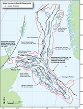 Figure 15. Distribution of the Upper Jurassic synrift plays and their associated extensional fault systems. Deflation of the North Sea dome leads to the shallow-marine depositional systems backstepping to concentrate the fairways in the Witch Ground graben and South Halibut Basins of the Outer Moray Firth, southern parts of the Viking Graben (including the Beryl embayment), and in and on the margins of the Central Graben and Horda platform. The onset on major rifting subsequently leads to the development of basin-margin submarine fan aprons in the South Viking Graben and the erosion of footwall highs in the East Shetland Basin. Many of the tilted fault blocks of the Brent province develop shoreline clastic fringes to an island archipelago and deep-water turbidite reservoir sandstones on their dip-slopes and neighboring hanging-wall depocenters.
The shallow-marine reservoirs characterize the Callovian, Oxfordian, and lower Kimmeridgian. They include the Hugin, Fulmar, Scott, and Piper Formations in the United Kingdom and record short periods of progradation in what is otherwise dominated by backstepping toward the central North Sea. The main driver for the retrogradational stack of shallow-marine deposition was transgression resulting from accelerated subsidence as the North Sea dome collapsed (Underhill and Partington, 1993; Davies et al., 1996). However, normal faulting associated with the onset of rift activity also played a part in controlling reservoir distributions, thicknesses, and facies prior to their incorporation in large, tilted fault blocks (Fraser et al., 2003).
Progressive normal fault growth and linkage created large, tilted fault blocks within and on the immediate flanks of the trilete rift system, which grew in length and increased their displacement during the course of the extensional episode (McLeod and Underhill, 1999; Dawers and Underhill, 2000; McLeod et al., 2000, 2002; Cowie et al., 2005). The resultant footwall closures that characterize the extensional fault blocks host the aforementioned prerift Brent Group, Cook Formation, and Statfjord Formation reservoirs (Figure 15).
The development of the fault blocks also led to shallow-marine deposition being instigated around exposed blocks to create an island archipelago during the main (upper Kimmeridgian and Volgian–Tithonian) phase of rift activity. The resultant subaerial exposure of the Brent Group and older formations led to their flushing and leaching by meteoric waters, something that commonly enhanced their reservoir properties (Ashcroft and Ridgway, 1996). In addition, many of the fault blocks experienced gravity-collapse to create a series of footwall-mounted fault scarp degradation complexes that proved to be a challenge to produce from during the late life of the fields (e.g., Ninian [Underhill et al., 1997; Brent [Taylor et al., 2004]). Basinward migration in the locus of extension and accelerated rift-related subsidence (Gupta et al., 1998) led to deepening of the Viking Graben relative to the structures of the East Shetland Basin, something that subsequently aided petroleum charge via fill-and-spill from basinal kitchens.
Active normal faulting led to proximal coarse clastic apron of breccio-conglomerates and axial sandstones forming large hanging-wall and basinal plays in the South Viking Graben (Figure 16). The most notable examples line its western margin to create the “Brae trend.” The fields that make up the play comprise South, Central, North, and East Brae, Toni, Tiffany, Thelma, Pine, Larch, Oak, and Sycamore. The fields occur in a series of anticlines formed through postdepositional (Lower Cretaceous) contractional reactivation (structural inversion) of the precursor normal faults. More axial areas of the basin also received clastic supply routed through major graben margin relay zones to create the Miller, East Miller, and Kingfisher fields. Charge was generated from the subsequent subsidence of the Kimmeridge Clay Formation to create a self-sourcing, self-sealing petroleum system in the South Viking Graben. Onshore analogues for the play exist in a narrow coastal strip between Brora and Navidale near Helmsdale on the northeastern Scottish coastline, the only part of the North Sea rift system that rises to outcrop in the basin.
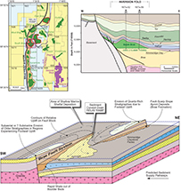 Figure 16. Montage showing the depositional setting for Upper Jurassic (synrift) deposition along the active margins of the South Viking Graben and Moray Firth Basin. The cross section depicts the proximal-distal facies relationships seen in the Brae trend. The interdigitation between the coarse clastic apron and the sandstones in the basin axis are thought to reflect different sedimentary entry points from the immediate basin-margin and supply through a major relay ramp between two overlapping extensional faults, respectively (Erratt, 1993). OWC = oil-water contact; TVDSS = true vertical depth subsea.
Syntectonic deposition sets up several stratigraphic plays where Upper Jurassic sandstones dip their toes into, or are encased within, mature kitchen areas, notably at the Buzzard field in the Outer Moray Firth (Ray et al., 2010; Taylor et al., 2020; Figure 17). Other synrift reservoir exemplars occur elsewhere in the western rift arm (e.g., Piper, Ettrick, and Galley fields [Williams et al., 1975; Boote and Gustav, 1987; Hurst et al., 1996]), in the South Viking Graben (e.g., Kingfisher and Miller fields), the Fulmar field (Johnson et al., 1986) and other discoveries in the Central Graben (e.g. Erratt, 1993; Price et al., 1993) and its western margin (e.g. Wakefield et al., 1993; Stewart et al., 1999), and the East Shetland Basin (e.g., Vigdis, Tordis, and Cladhan fields [Dahl and Solli, 1993; Dawers et al., 1999; Williams et al., 2020]).
 Figure 17. West-east seismic line illustrating the westerly pinch out of Upper Jurassic sequences that lead to the creation of a major stratigraphic trap that houses the Buzzard field (Ray et al., 2010; Taylor et al., 2020), the main sandstone reservoirs for which are encased within the Kimmeridge Clay Formation source rock and seal. Although immature at Buzzard itself, the Kimmeridge Clay is mature to the east and charge of the stratigraphic trap occurs because the reservoir sandstones dip their toes into the kitchen area. Depth track in feet. C.I = contour interval; CP = central panel; GR = gamma ray.
The platform areas that surround the main rift system also experienced shallow-marine deposition during the latter stages of the Oxfordian–Kimmeridgian (Volgian). The most notable examples include Sognefjord Formation, which forms the main reservoir in the supergiant Troll field (Figure 18) (Vollset and Doré, 1984; Dreyer et al., 2005; Holgate et al., 2013) and intra-Draupne sandstones situated around the Horda platform, Jæren, and Utsira highs (e.g., at Johan Sverdrup; Figure 19) (Olsen et al., 2017; Rønnevik et al., 2017), which create significant reservoir play fairways on the eastern flanks of the Viking Graben. Similarly, depositional systems characterizing the eastern margins to the Central Graben are ascribed to the Ula Formation and act as reservoirs in the Ula and Gyda fields.
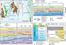 Figure 18. Plan view, cross section, and stratigraphy of the Troll field. Located in the Horda platform area, the field consists of three main fault-bound compartments in which oil and gas is hosted by Upper Jurassic shallow-marine reservoirs belonging to the Viking Group (Holgate et al., 2013). As well as being the largest discovery in the North Sea rift, the neighboring license forms Norway’s first Carbon Storage Exploration License (EL 001), which will see injection into the Lower Jurassic Johansen Formation (Fm). CCUS = exploratory carbon capture, utilization and storage well; Grp = Group; MFS = maximum flooding surface; MSL = mean sea level; SYS. = system.
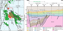 Figure 19. West-east cross section across the Johan Sverdrup field, a giant oil discovery located in a block awarded in the Norwegian First Round but which remained undiscovered until 2010 (Rønnevik et al., 2017). The field hosts stacked reservoirs in the Upper Jurassic, Statfjord and Zechstein. The main reservoirs represent Upper Jurassic synrift sequences located in a bifurcating channel system that lies above a Triassic half graben. The Upper Jurassic depositional system drained northwest off the platform into the Viking Graben from which charge has migrated in during the late Cenozoic to present day to fill a closure created by early Cenozoic structural inversion of the basin-bounding precursor normal fault. Grp = Group; TWT = two-way traveltime.
Lower Cretaceous
Most of the major extensional structures became dormant toward the end of the Upper Jurassic and, unlike in the neighboring Atlantic Margin, with the notable exception of the Outer Moray Firth and Magnus area, relatively few structures display evidence of normal faulting that extended into the Lower Cretaceous. Nevertheless, the role of Upper Jurassic rifting continued to have a major influence and the consequent stratigraphic architecture was consistent with that of a postrift infill and drape of its remnant, and sometimes significant (kilometer-scale), rift bathymetry. Continued erosion of the hinterland and platform areas led to clastic supply into the basin, most notably in the Witch Ground graben and South Halibut trough areas of the Outer Moray Firth (e.g. Bisewski,1990), where a notable reservoir play fairway exists in which several discoveries have been made (Wilson et al., 2005) (Figure 20).
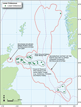 Figure 20. Distribution of Lower Cretaceous play fairways. Their concentration in the Moray Firth rift arm is a reflection of the proximity of the western sources. The main reservoir systems largely populate a depocenter on the southern side of the Halibut horst, but also include areas of the horst itself (e.g., the Captain field), the faulted margins of which were reactivated during early Cenozoic uplift.
Initially proven by the discovery of biodegraded low-API (heavy and viscous) oil in the Captain field on the Halibut horst and the Claymore and Scapa fields on its northern flank (Figure 21A), the Lower Cretaceous play really took off in the 1990s when a series of successes were recorded on its southern side. Originally termed the “Kopervik trend,” facies and stratigraphic relationships have demonstrated that the depositional system comprises three main clastic reservoirs: the Punt, Coracle, and Captain Sandstone Members, all of which were derived from western areas (Argent et al., 2000, 2005). The eastern extent of the fairway is determined by shale-out beyond the Brittania field, and no equivalents have yet to be found in the Central Graben. The successful appraisal of the play has led to field developments at the Atlantic, Blake, Cromarty, Goldeneye (Figure 21B), and Hannay fields (Jeremiah, 2000; Law et al., 2000; Wilson et al., 2005). Following the cessation of production at Goldeneye, significant efforts have been made to repurpose the depleted field as a carbon storage site (Stewart and Marshall, 2020). Similar efforts are also being made at the Atlantic and Cromarty fields to the west with a view to hooking them up to the St. Fergus terminal in northeastern Scotland.
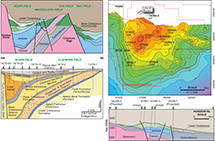 Figure 21. Examples of fields with Lower Cretaceous reservoirs resulting from the early postrift infill of remnant rift bathymetry. The Scapa and Claymore fields lie in the Witch Ground graben located on the northern side of the Halibut horst (Harker et al., 1991) and represent examples of coarse clastic infill of a major extensional half graben (modified after Sinclair and Riley, 1995). The Goldeneye field lies in the South Halibut trough located to the south of the Halibut horst and is part of the Kopevik fairway that also contains the depleted Atlantic and Cromarty fields, which together with Goldeneye are now being examined as potential carbon storage sites (Stewart and Marshall, 2020). CAC = central area Claymore; GOC = gas-oil contact; GYA = Goldeneye development well; NAC = northern area Claymore; N.P. = Formation not penetrated; TVDSS = true vertical depth subsea.
Upper Cretaceous and Lower Paleocene Carbonates
Being fine grained (micritic) in nature, Upper Cretaceous Chalk is not a naturally good reservoir. Furthermore, its burial leads to mechanical compaction, pressure solution, and calcite reprecipitation, all of which are detrimental to reservoir properties. Despite these challenges, Upper Cretaceous and lower Paleocene (Danian) Chalks are the host to a cluster of oil and gas fields in the Central Graben (Megson, 1992; Figure 22), including the Ekofisk, Machar, Mungo, and Pierce fields, where mobilization of Zechstein Group salt has created diapirs or pillows in its overburden. There has also been success in the Rembrandt and Vermeer fields in the Dutch sector (van Lochem, 2018).
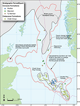 Figure 22. Distribution of Upper Cretaceous play fairways. The majority of fields cluster around the southern half of the Central Graben, Upper Cretaceous and lower Paleocene chalks occur. The domal and periclinal structures hosting the carbonate reservoirs have been created by salt mobility (halokinesis) of the buried upper Permian Zechstein Group that form a suite of diapirs and pillows. The limit of Upper Cretaceous Chalk Group play is controlled in part by its northward transition into shales of the Shetland Group.
The play is dependent upon access to charge (Cornford, 1994) primarily through vertical leakage resulting from seal failure of deeper reservoirs and the creation of preferential migration routes. This may occur via faults but also because of hydraulic top seal failure in the absence of any through-going deep-seated faults. As such, chalk fields are primarily found in the areas of highly overpressured deeper sections that lack a Paleocene clastics lying directly above since they act as a thief zone in such areas. The change in Upper Cretaceous deposition toward the north is characterized by replacement of the Chalk Group by mudstones belonging to the Shetland Group, something that limits the extent of the play (Figure 22). The Shetland Group forms the supracrop to the Base Cretaceous unconformity over large parts of the East Shetland Basin, where it forms the top seal to many of the fields in the Brent province such as above the Snorre (Figure 9) and Brent fields.
Critical factors that aid production at each field are the development of a radial and concentric fracture network that can enhance permeability (e.g., at Gorm in Danish waters; Freeman et al., 2015) and the presence of resedimented chalks that were reworked off the bathymetric high, both of which are consequences of ballooning diapirs (Megson, 1992; Megson and Hardman, 2001). A lack of significant lateral migration exists in the Chalk because of insufficient formation scale permeabilities away from the aforementioned fracture networks, which can present a major petroleum engineering challenge.
Paleocene Clastics
A dramatic change in sedimentation occurs in the Paleocene with clastic deposition replacing carbonates, the supply of which was largely from the west and funneled along the Moray Firth rift arm (Parker, 1975; Ahmadi et al., 2003). Well subsidence curves record the effects of the uplift and show the variable effects associated with the development of the Iceland plume in advance of Atlantic Ocean opening (Figure 23). The uplift reached its maximum elevation during the late Paleocene, and western areas of the Moray Firth are characterized by progressive subcrop and fault displacement of Cretaceous and Jurassic sequences toward the Scottish coast (Figure 24). The subcrop attests to the permanent effect of early Cenozoic uplift resulting from underplating beneath northern Britain (Guariguata-Rojas and Underhill, 2017). Some (Upper Jurassic) synrift precursor faults experienced reactivation to accommodate the uplift (Argent et al., 2002). The tilt and forced regression that resulted is recorded by rotation, progradation, offlap, incision, and systematic variation in well burial curves in the Outer Moray Firth (Milton et al., 1990; Hillis et al., 1994) and the development of paleogeomorphic traps on the East Shetland platform (e.g., the Bentley and Bressay discoveries; Underhill, 2001).
 Figure 23. Burial curves depicting the variation in basin subsidence that characterizes the North Sea rift system. While areas to the east experience fairly continuous subsidence and are at their greatest depth of burial today, more westerly ones record the effects of transient and permanent uplift, something that leads to progressive subcrop of early Cenozoic and older sediments toward the Scottish coastline. The occurrence of Upper Jurassic exposures along a narrow coastal strip between Brora and Helmsdale in northeastern Scotland represent the only place where the synrift sediments can be inspected in the field.
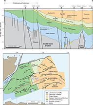 Figure 24. Geological cross section and plan view geologic map showing the evidence for early Cenozoic uplift and fault reactivation in the western part of the Moray Firth rift arm (Guariguata-Rojas and Underhill, 2017). The transient nature of uplift is illustrated by the development and drowning of a dendritic drainage network that incised into easterly prograding deltaic foresets in the Outer Moray Firth. Fm = Formation; Undiff. = undifferentiated.
The products of the regional erosion were shed eastward to create an extensive deep-water clastic depositional system that dominated the Paleogene (Stewart, 1987; Galloway et al., 1993; Hartog Jager et al., 1993; Ahmadi et al., 2003) that includes the giant Forties field (Warmsley, 1975; Hill and Wood, 1980). The occurrence of the Fladen Ground Spur promontory to the northeast of the Moray Firth rift arm led to the main sediment transport pathways being deflected southeast to create an extensive reservoir play fairway in the Central Graben (Figures 25, 26) (Stewart, 1987; Ahmadi et al., 2003). Detailed analysis of its internal architecture by core description, well-log analysis, and the use of seismic attributes has demonstrated that the fairway contains numerous linear channel belts (Figure 26) (Whyatt et al., 1992). Their occurrence had a particularly important control on exploration success since better reservoir systems are set within lower quality interfluves, something that was not initially recognized (Figure 26) (Whyatt et al., 1992). The latter had consequences in early exploration, not least for the Nelson field in block 22/8, where one of the first wells in the basin was interpreted to lie beyond the southeastern limit of the Forties sandstone fan and plugged and abandoned with oil shows as a result (Whyatt et al., 1992).
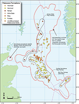 Figure 25. Distribution of Paleocene play fairways. The reservoir occurrence after the peak of transient uplift attests to the continued role of sediment supply to form deep-marine turbidite play fairways that include Forties, Arbroath, Montrose and Nelson.
 Figure 26. Diagram depicting the role that sandstone channel distribution had in controlling the extent of exploration success within the lower Paleocene, Forties Sandstone Member play in the central North Sea (Parker, 1975; Ahmadi et al., 2003). The recognition that the channel complexes were of finite width was fundamental in the discovery and exploitation of many fields in the area and was especially important in the successful appraisal and development of the Nelson field (e.g. Rose et al., 2020 and references therein). Lower diagram modified after Whyatt et al. (1992). Bal = Balder; CRET = Cretaceous; Ekof. = Ekofisk; Fm = Formation; Maastr. = Maastrichtian; Mau = Maureen; Roga = Rogaland; Se = Sele; TD = total depth.
Thin-bed pay has been successfully produced at Forties and its satellite fields. From 2004 to 2012, more than 100 bypassed pay targets were drilled in the decade after operatorship passed BP to Apache to establish a late life plateau of 50,000–60,000 BOPD (Rose and Pyle, 2015; Rose et al., 2020). In recent years, efforts have also been made to extend the play into more distal parts of the depositional system where they increase in complexity as the sand body architecture decreases in size, turbidites are thin-bedded, have a lower net-to-gross ratio, and are less channelized (Hempton et al., 2005). Several field developments have resulted including those at Blane and Starling.
The fact that thick reservoir sequences run along the axis of a buried intermediate ridge (the Forties-Montrose high) suggests that it had a limited role in controlling synsedimentary deposition. However, it evidently contributed to the postdepositional formation of the closure because of compactional drape or structural rejuvenation. Significant closures also occur above or around salt diapirs and pillows (e.g., at Machar [Sayer et al., 2020]; Figure 27), some of which had a demonstrable role in creating bathymetric relief that controlled deposition (Davison et al., 2000a) and in compartmentalizing the field through the development of radial fault patterns (Davison et al., 2000b). Finally, halokinesis also appears to have had a role in folding some of the synrift normal faults (e.g., at Shearwater; Figure 28).
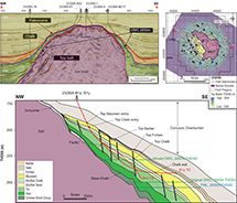 Figure 27. Cross sections and plan view image of the Paleocene trap of the Machar field that has been created on the flanks of an upper Permian (Zechstein Group) evaporite diapir (Sayer et al., 2020). FWL = free-water level; OWC = oil-water contact; TD = total depth; TVDSS = true vertical depth subsea.
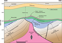 Figure 28. Cross section across the Shearwater field illustrating how late-stage (Cenozoic) halokinesis has led to refolding of the field-defining normal fault, rotation of the main field with consequent steep dips, and the creation of a hanging-wall anticline devoid of reservoir section to the east.
Eocene Clastics
The North Sea rift system continued to experience transgression during the lower (Ypresian) to middle (Lutetian and Bartonian) Eocene as subsidence resumed following the transient phase of uplift that peaked in the Paleocene. The initial stages of base-level rise are recorded by the Balder Formation, a water-lain volcanic deposit, the source of which was the Iceland plume. The intercalation of clastic and volcanic sediments is well illustrated by the Balder field itself. Significantly, despite the renewed flooding of the basin margins, denudation of the hinterland and punctuated relative sea-level variation was enough to maintain a high sediment flux. The resultant clastic supply created prospective Eocene reservoir play fairways in the South Viking Graben, which host the Frigg field and the Nuggets cluster (Figure 29). Additional play fairways also exist on the western flank of the Central Graben, where the Tay Sandstone Member forms the main reservoir in the Gannet and Guillemot fields (e.g., Armstrong et al., 1987; Banner et al., 1992) (Figure 29). Continued sea-level rise eventually led to the cutoff in clastic supply and development of a regional seal.
 Figure 29. Distribution of Eocene play fairways. Although sediment supply was dropping off as basin subsidence drove base-level rise, transgression, and reduced levels of sediment supply, sandstones continued to reach the basin to form important reservoirs. Middle Eocene clastic reservoirs represent the last main prospective interval before drowning of the basin margins cut off sediment supply and the deposition of a regional seal. Undif. = undifferentiated.
An unusual byproduct of the renewed subsidence was postdepositional remobilization of fluidized sediment from a buried sandstone parent, which have been termed “injectites.” The clastic dewatering of overpressured reservoirs produced a trellis network of dykes, sills, and wings in the overburden (Figure 30) (Jonk et al., 2005; Erratt et al., 2010; Wild and Briedis, 2010). The resultant architecture and inherently complex plumbing system means that they are not only difficult to charge but can also present significant development challenges. Identifying “top porosity” in the injectites of the North Sea has been particularly difficult and has compromised hydrocarbon columns extending into deeper massive reservoirs in many instances (Erratt et al., 2010). In the case of the Leadon field, this was a root cause of the underperformance of the asset and production only lasted for 5 yr. However, in other cases, injectites have displayed excellent reservoir characteristics with porosities in excess of 35%, permeabilities up to 7 d and accommodated long hydrocarbon columns.
 Figure 30. Diagram showing the location of the main suite of fields with injectite reservoirs in the South Viking Graben. Cross section through the fields highlight their complex three-dimensional geometry with the formation of wings that cross normal stratal boundaries (modified from Wild and Briedis, 2010).
Many of the fields that are characterized by injectites lie to the south of Frigg (Figure 30), in an area covering the South Viking Graben (e.g., Graue, Gryphon, Harding, Jotun, Leadon, and Maclure fields of the United Kingdom; Graue, Jotun, and Volund fields in Norway [Huuse et al., 2004; Hurst et al., 2015]; and the Alba field in the Outer Moray Firth [Duranti et al., 2002]). Recent advances in seismic acquisition and processing technology, coupled with rock physics analysis enabling derisking and fluid characterization, have led to continued active exploration and development of such targets.
PETROLEUM SYSTEMS
As the aforementioned account of the main reservoir’s shows, there is a plethora of play fairways in the North Sea rift (Parsley, 1984; Pegrum and Spencer, 1990; Spencer et al., 1996; Johnson and Fisher, 1998), which spans the stratigraphic column to create several different but overlapping petroleum systems. As with other successful global rift systems (Mann et al., 2003; Davison and Underhill, 2012), the key to their exploration potential is that they occur within several traps created by extension, structural inversion, halokinesis, compensational stacking, and compactional drape, all of which predated source rock maturation and charge (Cornford, 1998).
In the case of the North Sea, the postrift history of almost continuous gentle, thermal subsidence (Wood and Barton, 1983; Barton and Wood, 1984) leads to maturation being instigated in the Late Cretaceous. From that critical moment to the present day, petroleum migration has occurred over ever larger areas, with structures close to the deeply buried grabens receiving charge and being filled first before spill from them led to updip charge of shallower structures located toward the basin margins.
The charge of extant traps containing multiple reservoir-seal pairs makes for a highly efficient and effective petroleum system, the main elements of which can be summarized in an events chart (Figure 31). It is important to stress that the charge of prerift reservoirs does not imply downward migration but rather serves to illustrate that the fill of stratigraphically older formations is by virtue of the fact that they lie in more structurally elevated positions than the Upper Jurassic Kimmeridge Clay Formation source rock from which the oil and gas was derived.
 Figure 31. Petroleum systems events chart summary for the North Sea Rift Super Basin. The key to the prolific success of the basin is the fact that multiple reservoir-seal pairs occur in traps that were extant before postrift subsidence led the main Upper Jurassic source rock to become mature. As such, the North Sea shares characteristics with other highly prospective global rifts.
DISTRIBUTION OF PETROLEUM RESERVES AND RESOURCES
The geographical limits of the North Sea rift’s petroleum system encompasses the north-northeast to south-southwest–striking Viking Graben, the northwest-southeast–striking Central Graben, and the west-east–striking Moray Firth rift arms and their neighboring platforms. The Viking Graben hosts the largest density of giant fields, followed by the Central Graben. The Moray Firth contains the fewest fields, something that largely reflects the detrimental effects of increasing amounts of uplift and fault reactivation to the west with the large fields mainly concentrated in the Outer Moray Firth. The variation in petroleum resources may be directly attributable to differences in the geological evolution and relative timing of deformation in each rift arm and whether the basin’s postrift subsidence history is punctuated by events that create additional traps, leading to kitchen areas being switched off, structures being breached (e.g., in western parts of the Moray Firth), and biodegradation of oil (e.g., in the marginal, East Shetland, and Western platform areas).
Few attempts have been made to compile reserve figures exclusive to and for the whole North Sea Rift Super Basin with most previous studies having been undertaken on a country-by-country basis. In this paper, we have sought to take a holistic view and to document the total discovered volumes for the rift province as a whole and to illustrate, compare, and contrast the relative contribution driven primarily by the geology.
From the North Sea Rift Super Basin, 95.6 billion BOE have been produced to date, 53 billion BOE of which has been extracted from Norway, 36.8 billion BOE from the United Kingdom, and 5.8% from Denmark (Figure 32). Analysis of the data allows for comparisons to be made for each rift arm, tectono-stratigraphic megasequence, and reservoir stratigraphy (Figure 33). Taken as a whole, it is evident that Middle Jurassic prerift plays and Paleocene postrift plays are the main contributors to the success of the super basin with Upper Jurassic synrift plays also playing a significant role compared to the other reservoir play fairways (Figure 33).
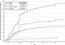 Figure 32. Comparison of proven and probable reserves for the North Sea Rift Super Basin and the relative contribution by country.
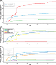 Figure 33. Comparison of proven and probable reserves for each (A) rift arm; (B) tectono-stratigraphic megasequence; and (C) stratigraphical interval. Middle Jurassic, Upper Jurassic, and Paleocene reservoirs have contributed the largest amounts overall.
When the contribution of each tectono-stratigraphic interval is broken out for each area, the data clearly demonstrate how the variation in geology controls the volumes and value in different parts of the basin (Figure 34). In the northern North Sea, prerift plays are dominant (Figure 34A), followed by a significant contribution from synrift plays, thanks largely to the giant Troll and Johan Sverdrup fields in Norway. In contrast, postrift reservoirs are in the ascendency in the central North Sea followed by synrift ones (Figure 34B). In the third rift arm, the Moray Firth Basin, the major petroleum contribution comes from Upper Jurassic (synrift) reservoirs, followed by postrift ones (Figure 34C).
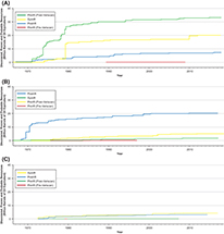 Figure 34. The relative contribution of proven and probable reserves by tectono-stratigraphic megasequence for each of the three rift arms: (A) Viking Graben; (B) Central Graben; and (C) Moray Firth. Whereas prerift reservoirs are the major contributor in the Viking Graben, the postrift contributes the most in the Central Graben, and the synrift is dominant in the Moray Firth.
The presence of significant overpressure (e.g., Giles et al., 1999), distribution of deep reservoirs, and its impact upon seal integrity, hydrocarbon column-length, and remigration dominated exploration thinking as activity increasingly focused upon the Central Graben after the initial burst of activity in the Brent province (Cayley, 1987; Gaarenstroom et al., 1993; Nicholson and Cayley, 1998; Helgeson, 1999; Erratt et al., 2005). Although significant in terms of reserves, the “Brent era” proved to be a comparatively short-lived chapter in the history of the basin. The challenges that are associated with the greater geological complexity developed in the central North Sea explains the decline in success rates and discovered volumes that has characterized the basin ever since (Erratt et al., 2010). However, it is important to note that the high-pressure high-temperature Triassic and Jurassic plays of the Central Graben continue to yield globally significant discoveries, even at such an advanced stage, with recent discoveries likely to be in excess of 100 million BOE ultimately recoverable resources at Glengorm (discovered 2019) and Isabella (discovered 2020).
The North Sea basin is expected to produce a further 10 to 20 billion BOE by 2050 (Oil and Gas Authority, 2019). Most of the super basin’s giant fields were discovered in the first decade of exploration and they have contributed to more than half of the total production in the basin (Figure 35). This is consistent with many other basins and simply reflects the fact that the biggest structures were recognized and drilled first.
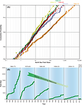 Figure 35. Graphical representation of field sizes for the five decades of the North Sea’s exploration history. (A) The average field size was 285 million bbl over the period 1964–1983, 57 million bbl between 1984 and 2003, and 48 million bbl between 2004 and present. (B) Plot showing the decline curves for each decade from illustrating the progressive drop in resources exhibited by the basin.
A comparison with petroleum provinces in neighboring areas shows the North Sea Rift Super Basin’s oil and gas contribution dwarfs all the other United Kingdom provinces, with the exception of the Anglo-Polish Basin and West Shetlands. The total production from the UKCS is approximately 52 billion BOE, meaning the North Sea rift has contributed more than 70% of the United Kingdom’s total oil and gas. Similarly, the North Sea rift province also makes a far more significant contribution than either the Norwegian Sea or Barents Sea in Norway.
A review of the volumes produced demonstrates that the northern and central North Sea dominate, something that in turn leads to Norway and the United Kingdom being much more significant beneficiaries than Denmark. At the end of 2019, 262 fields were in production in the North Sea Rift Super Basin (177 in the United Kingdom, 66 in Norway, and 19 in Denmark). Although several fields have been brought on stream in Norway and the United Kingdom in the past decade, no discoveries have been developed in Denmark.
The production profile shows that there was a consistent increase through the last two decades of the twentieth century in all areas (Figure 35). In the United Kingdom, offshore production peaked at 5.34 million bbl of oil equivalent per day (BOEPD) in January 2000, the vast majority of which (3.63 million BOEPD) was produced from the North Sea Rift Super Basin. However, by January 2020, United Kingdom production rates had dropped to 1.32 million BOEPD (458 million BOE for the year 2019) prior to an upswing following the hook up of the Buzzard field. The latter was the United Kingdom’s largest producer at 116,000 BOEPD in January 2020, but has since dropped to third behind Franklin and Culzean fields. By way of comparison, production from the Brent field peaked at 679,556 BOEPD in February 1984 and at 587,472 bbl of oil equivalent per day from Forties in December 1978 (i.e., five times that of Buzzard three decades later).
EXTENDING THE LIFE OF THE MATURE BASIN
Conventional Exploration Opportunities
After 50 yr of exploration activity, the North Sea rift has evolved from a frontier basin to a mature oil and gas province, and although production has declined from historic highs at the turn of the twenty-first century, it continues to be an important source of petroleum in the United Kingdom and Norway. However, declining production efficiency, rising costs, and the investment challenges associated with the rapid fall of the oil price in 2014 led North Sea operators to shelve field developments, sell assets, and suspend their exploration programs. The supply chain suffered and rigs lay idle. It was at this point that the UK government initiated a review under the chairmanship of Sir Ian Wood with the aim of identifying, tackling, and solving the issues associated with barriers to activity. One outcome of the subsequent “Wood Review” (Wood, 2014) was to recommend the formation of a new regulatory body in the United Kingdom, the Oil & Gas Authority (OGA), which came into being in 2015. The OGA has made significant progress in regenerating the North Sea by making the UKCS a more competitive and attractive place to explore and develop. In particular, the OGA have encouraged enhanced asset stewardship, stimulated exploration, and seeded technological innovation in the basin. In doing so they have produced a roadmap for the super basin (Figure 35) that promotes collaboration with the aim to extend the life of and repurpose the basin as it transitions to supporting a low-carbon economy. These measures have placed the basin in a better position to withstand the worst effects of the COVID-19 pandemic and the associated fall in oil and gas prices in 2020, supported by the strong fundamentals of a globally competitive fiscal regime and operating metrics (average operating costs of approximately $15.5/BOE; production efficiency at 80%), and a new collaborative culture that is embracing change.
The OGA’s primary objective has been on maximizing economic recovery from all areas of the UKCS, including the North Sea rift. This objective, the central obligation, was updated in 2021 to add the obligation for operators and licensees in the UKCS to assist in meeting net zero targets, including through direct emissions reduction initiatives and carbon capture and storage projects (OGA, 2021). Historic efforts to revitalize exploration activity included the new, more flexible, “innovate” licensing regime, the acquisition of modern government-funded seismic data in frontier areas, enhanced asset stewardship with a published set of expectations and best practices for industry, broader reporting and disclosure of public data sets, the establishment of a new National Data Repository, and the support of collaborative academic and industry research projects to work up data and deliver insights. As part of the resource maturation and regulatory process, the OGA encouraged operators to drill NFE opportunities around producing fields, collaborate for infrastructure-led exploration, renew the search for high-impact prospects, and undertake work programs, fulfill firm obligations, or relinquish licenses in a timely manner, so that they can be offered and relicensed to new operators. It is worth adding that the basin is dominantly a conventional one by virtue of it being located offshore, the cost of chasing unconventional plays makes it prohibitively expensive to prosecute and to date, beyond hydraulic fracturing of some tight reservoirs, shale oil and gas has not been a focus for any operators.
Prior to 2020, the OGA’s work was beginning to pay off through increased industry activity in licensing rounds, a pick-up in drilling activity and exploration and appraisal well commitments, and the number of stranded assets now being developed and brought on stream. The last few years have also seen significant (>100 milion BOE) new hub-potential discoveries being made (e.g., Glengorm) and added production from over 30 new United Kingdom fields since the OGA was created, many of which are in the North Sea Super Basin. Based on known reserves, current estimates are that United Kingdom’s cumulative oil and gas production over the period 2016–2050 will now be 3.9 billion BOE higher than predictions made in 2015. It is clear, however, that unless oil prices rise and remain sufficiently high, many small and technically challenging discoveries will be left undeveloped, and reserves will be stranded. Without further investment in exploration, production is predicted to decline more rapidly, with current estimates of 0.76 million BOPD in 2035 (Oil and Gas Authority, 2020).
Even using the most conservative of the Climate Change Committee (2020) estimates for the oil and gas volumes countries like the United Kingdom require to fuel their economies, the amount of indigenous oil and gas produced will leave them short of their needs (Figure 36) and, thus, largely dependent upon imports, with all the consequences for energy security that entails. Domestic production in northwestern European countries also tends to have significantly lower emissions intensity than imported sources from elsewhere across the world; for example, liquid natural gas imports can be more than twice as emissions intense (59 kgCO2e/BOE) as the United Kingdom or Norwegian gas (22 kgCO2e/BOE and 18 kgCO2e/BOE, respectively) (Oil and Gas Authority, 2019). It therefore makes sense from a climate change perspective to maximize low-intensity domestic oil and gas while reducing the demand for higher-carbon imports and to drive that domestic supply to even better performance by taking additional measures such as reducing flaring and venting through, for example, offshore platform electrification from nearby renewable (wind farm) sources.
 Figure 36. Cumulative production curves for the United Kingdom and Norway for the period 1965–2050 showing how the peak in their production occurred around the turn of the Century. It is evident from the graph that the North Sea Super Basin is largely on a path of decline. Mature field management, near-field, and infrastructure-led exploration opportunities are likely to have primacy and may help reduce the rate of decline. The plot also shoes the production forecast for the UK out to 2050 and the roadmap to achieve zero net emissions. The tension between a demand to address carbon emissions and the need to continue to fuel a part of the economy through some, albeit less, oil and gas means that there will be an inevitable and increasing need for the United Kingdom to import from external sources, something that would lead to an increase in the country's carbon footprint.
Although interest in exploration has continued in the United Kingdom and Norway, it has dropped off significantly in Denmark and only one single application was received in the most recent license rounds. The decline in exploration activity combined with concern over carbon emissions led the Danish government to abandon future oil and gas exploration, and there will not be any further licensing rounds in Denmark. The UK government has subsequently reaffirmed as part of the North Sea Transition Deal (Department for Business, Energy and Industrial Strategy, 2021) that “an orderly transition is crucial to maintaining our energy security of supply, supporting high-value jobs, and safeguarding the expertise necessary to achieve a lower carbon future” and that future oil and gas licensing rounds will only be run with a “Climate Compatibility Checkpoint” to ensure alignment with wider climate objectives.
Repurposing and Reemergence of the North Sea Rift Basin for the Low-Carbon Energy Transition
As the North Sea’s petroleum resource has diminished, focus has shifted toward field abandonment, the decommissioning of the platforms and pipelines, and the considerable costs thereof. Furthermore, increasing attention has been paid to the need to decarbonize industrial clusters of northwestern Europe and its energy system that has led to the possibility that many depleted fields and their infrastructure could be used for green, renewable, low-carbon initiatives. These have included the identification of safe subsurface carbon, hydrogen, and methane gas storage solutions, wind farm construction, and the use of the basin’s geothermal heat sources (e.g., Department for Business, Energy and Industrial Strategy, 2020).
Significant efforts have been made to get carbon sequestration off the ground in recent years. Equinor (formerly Statoil) have been injecting CO2 into the Utsira Formation saline aquifer above the Sleipner field since 2006 (Furre et al., 2017). During late 2019 to early 2020, an exploration well (31/5-7), termed Eos, was drilled in the EL001 “Aurora” license (Figure 18). It forms part of the Northern Lights project that will see CO2 injection into the Lower Jurassic Johansen Formation saline aquifer reservoir that was encountered directly beneath the Troll field (Figure 18). The well proved that the formation has good quality flow characteristics, and may be suitable for injection of approximately 1.5 million tons of CO2 (MtCO2)/yr; Norwegian Petroleum Directorate, 2020).
Several attempts have also been made to initiate carbon storage in the United Kingdom sector. The first project was championed by BP in the early 2000s. They proposed to inject CO2 into the Miller field. Since the accumulation contained CO2 naturally, it was proven that it could retain it on geological time scales. Furthermore, because of its CO2 content, the platform and pipelines had been deliberately designed to cope with the highly corrosive effects of carbonic acid, a natural byproduct of the reaction between CO2 and aquifer waters. The thought was that CO2 injection could enhance oil recovery while simultaneously locking up CO2 in the ground. However, failure to win UK government support ultimately led to the project being abandoned in 2007 and the field was decommissioned.
The second major push for carbon sequestration occurred in 2010–2012 when the UK government held a competition to find the best offshore geological sites. Two projects made it to the final round, the White Rose Project, which promoted the use of a closure termed Endurance that contained a Triassic Bunter Sandstone Formation reservoir in the southern North Sea, and the Goldeneye field, which lay in the Lower Cretaceous Captain Sandstone Formation play fairway in the Moray Firth. Despite extensive studies being carried out (e.g., Marshall et al., 2017), the competition was abandoned in 2015 and the opportunity lost.
A third attempt is being made to resuscitate carbon storage in the North Sea. Centered on the aforementioned Goldeneye field, plus the Atlantic and Cromarty fields, within the same Captain Sandstone play fairway, the Acorn project is evaluating the risks and development options for storing carbon emissions from the St. Fergus Refinery near Peterhead in storage sites within this open aquifer complex. These fields have the advantage of being recently abandoned but not yet decommissioned and benefit from the Miller field’s CO2 export pipeline running nearby. The Endurance carbon store has also seen a renewed focus, led by the Northern Endurance Partnership (Net Zero Teeside and ZeroCarbon Humber), and new carbon storage licenses have recently been issued to Eni across the Hamilton and Lennox fields in Liverpool Bay and Harbour Energy’s V Net Zero project in the southern North Sea. Several additional carbon capture, utilization, and storage (CCUS) projects are also in the pipeline, which will further contribute to the large-scale deployment of CCUS that is an essential requirement to abate industrial and power emissions at the scale necessary to meet the scenarios laid out in the United Kingdom’s Sixth Carbon Budget (Climate Change Committee, 2020).
Additional carbon sequestration projects are looking into whether other depleted fields might serve to reduce emissions from the main industrial hubs that circle the North Sea (e.g., Rotterdam, Humber, Teesside, Grangemouth) or farther afield (e.g., Merseyside and southern Wales). The overall aim in the United Kingdom and Norway is to build up significant CO2 storage capacity to serve the region’s major industrial clusters and make a significant contribution to emissions abatement in accordance with national and international net zero climate goals. The United Kingdom is aiming to achieve a total injection rate of at least 130 MtCO2/yr by 2050, with a total storage capacity of approximately 3.9 gigatonnes of carbon dioxide to sequester carbon from current industrial processes, but also to support the development of carbon-neutral Blue Hydrogen schemes that will act as a stepping stone to support the infrastructure for longer-term Green Hydrogen schemes (Oil & Gas Authority, 2020, 2021). Several depleted fields in the North Sea were examined to see if they present a hydrogen storage option with a view to it being introduced into the gas network or to support transportation.
A significant effort is being made to decarbonize the electricity system, and this has resulted in large swathes of the seafloor now hosting windfarms. Some decommissioned platforms have also been redesigned to capture wind energy (e.g., at the Beatrice field in the Inner Moray Firth). In addition, other active platforms are expected to be connected to offshore windfarms for power supply (e.g., the Snorre and Gullfaks platforms that are expected to be linked to the Hywind Tampen floating offshore windfarm; Norwegian Petroleum Directorate, 2019). Other renewable activities include the use of geothermal energy contained in hot waters that circulate in buried reservoirs and solar energy sources to help heat and power offshore installations with the aim of making them self-sustaining and less reliant on the grid. A successful translation to face a low-carbon future will lead to the life of the North Sea Rift Super Basin being extended and its reemergence to face the challenge of net zero.
CONCLUSIONS
The trilete North Sea rift system is a prolific petroleum super basin that has produced 95.6 billion BOE to date. The rift straddles international borders and has contributed significantly to the economic prosperity of the United Kingdom, Norway, Denmark, Germany, and the Netherlands. Although the rift basin’s petroleum system is dominated by Upper Jurassic source rocks belonging to the Humber Group, it is characterized by a rich play diversity with reservoirs spanning the whole stratigraphic column and each of its component (pre, syn-, and postrift) tectono-stratigraphic megasequences contribute to its commercial success. The main reservoirs comprise the fluvio-deltaic and shallow-marine reservoirs of the prerift (Middle Jurassic) Brent Group, postrift (Paleocene) deep-water clastic systems of the Forties Formation in the Central Graben, and synrift (Upper Jurassic) clastics in the Viking Graben and its margins. A disproportionate number of fields occur in the Central and Viking Grabens, reflecting a contrast in their subsidence history leading to their greatest depth of burial today while the Moray Firth rift arm experienced varying degrees of transient to permanent uplift toward the west that curtailed source rock maturation.
After six decades of exploration and production, it is recognized that the petroleum province is mature and largely creamed. However, some exploration opportunities remain and the prospects that lie close to existing fields or infrastructure are the most likely to be developed first, since commercial and fiscal terms continue to be favorable, and small discoveries can be extremely valuable. There is also an increasing awareness that the North Sea is well placed to contribute to decarbonizing industrial hubs that exist on its margins. It is anticipated that its subsurface will be repurposed for the low-carbon energy transition to help address the challenge of net zero emissions. Carbon capture and storage has occurred at Sleipner since 1996, and other pioneering low-carbon projects are being progressed (e.g., the Northern Lights/Longboat and Acorn projects). In addition, recent wind power developments and geothermal energy derived from buried reservoirs have a potential to provide local sources of electricity and heat that will reduce the basin’s carbon footprint. Taken together, it is evident that the continued exploration and development of the hydrocarbon resources, coupled with the use of novel, sustainable renewable energy technologies have a potential to extend the life of the province and lead to its rejuvenation as a low-carbon basin. As such, the North Sea seems likely to continue to be an important energy hub and site for subsurface gas storage serving the needs of the countries that border it and beyond.
ADDITIONAL WEB RESOURCES
https://www.ogauthority.co.uk/media/5942/oga_reserves__resources_report_2019_jk.pdf, accessed November 30, 2020.
https://www.ogauthority.co.uk/news-publications/publications/2019/oga-overview-2019, accessed November 30, 2020.
https://factpages.npd.no/, accessed March 12, 2021.
https://npdfactpages.npd.no/, accessed March 12, 2021.
https://ens.dk/en/our-responsibilities/oil-gas/reports-oil-and-gas-activities, accessed October 21, 2020.
AUTHORS
John R. Underhill is the director of the Interdisciplinary Centre for Energy Transition and professor of geoscience and energy transition at Aberdeen University, Scotland. He is the academic executive director of the Centers of Doctoral Training in Oil & Gas and in GeoNetZero. He populates the Scottish Science Advisory Council and United Kingdom’s (UK) Exploration Task Force. John is a recognized expert on the North Sea Basin and is leading efforts to repurpose it for carbon storage and the energy transition. He has been an AAPG member for almost 40 years during which time he has received AAPG’s George C. Matson, Grover E. Murray Distinguished Educator, and Ziad Beydoun awards as well as the Geological Society’s Lyell Medal and their Energy Group’s Silver Medal. He is the corresponding author of this paper.
Nick Richardson leads the Exploration and New Ventures team for the UK OGA. He has a B.A. degree in geology from Oxford University, an M.Sc. degree from The University of Edinburgh, and a Ph.D. from ETH Zurich. Nick worked for Shell, Maersk Oil, and Dana Petroleum prior to joining the OGA in 2016.
ACKNOWLEDGMENTS
This paper was first presented at the AAPG Super Basins Conference in Houston in March 2018. J.R.U. acknowledges Charles Sternbach, Claudio Bartolini, and AAPG Editor Robert K. Merrill for their encouragement and invitation to publish the outcomes of the study. We thank Duncan Erratt and the editors of the thematic set for their constructive and helpful reviews. The paper builds upon the work undertaken by numerous students based in the Grant Institute of Earth Science at The University of Edinburgh and in the Centre for Exploration Geoscience in the Institute of GeoEnergy Engineering at Heriot-Watt University. Shell is thanked for financial support for the Wouter Hoogeveen Laboratory in which some of the work was undertaken and for supporting J.R.U.’s participation in the AAPG Super Basins meeting. Paul Renaut (Sparos Graphics) is thanked for drafting the diagrams. The UK OGA, Norwegian Petroleum Directorate, and Danish Energy Agency are thanked for the publication of analyses derived from the resource assessments for their respective offshore areas, available on their websites under the relevant licenses. We thank the staff who support the OGA’s National Data Repository, whose dedication has enabled the public release of UK data on which many of our interpretations are based. Nick Richardson’s contribution has been approved by the operations director of the OGA. The authors also acknowledge and credit the staff of the OGA and predecessor organizations (Department for Business, Energy and Industrial Strategy; Department of Energy and Climate Change; Department for Business, Enterprise and Regulatory Reform; Department of Trade and Industry, etc.) for the skill and care that they have exercised, and continue to exercise, in maximizing the value of the North Sea and wider United Kingdom Continental Shelf for the benefit of the nation.