The AAPG/Datapages Combined Publications Database
AAPG Bulletin
Figure
AAPG Bulletin; Year: 2023; Issue: August DOI: 10.1306/04042322097
Return to Full Text
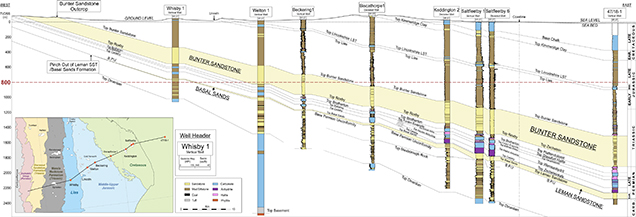
Figure 9.
Southwest-northeast–oriented cross section based on a well correlation that transects the English coastline and onshore outcrop patterns (inset). The Bunter Sandstone Formation is shown to crop out to the west of Lincoln, whereas the Leman Sandstone Formation pinches at a depth of approximately 400 m to the west of Whisby. The Bunter Sandstone Formation and the Leman Sandstone Formation onshore rise to shallower depths than the 800 m depth contour, which is the minimum burial for potential carbon capture and storage sites. This well correlation contains information from the Oil and Gas Authority and other third parties, British Geological Survey materials (© United Kingdom Research and Innovation, 2022), and data from the UK Onshore Geophysical Library. This figure includes content supplied by IHS Markit (Copyright © IHS Markit, 2022. All rights reserved). BPU = Base Permian unconformity; LST = limestone; MID. = Middle; SST = sandstone; TVDSS = true vertical depth subsea.
Figure 9. Southwest-northeast–oriented cross section based on a well correlation that transects the English coastline and onshore outcrop patterns (inset). The Bunter Sandstone Formation is shown to crop out to the west of Lincoln, whereas the Leman Sandstone Formation pinches at a depth of approximately 400 m to the west of Whisby. The Bunter Sandstone Formation and the Leman Sandstone Formation onshore rise to shallower depths than the 800 m depth contour, which is the minimum burial for potential carbon capture and storage sites. This well correlation contains information from the Oil and Gas Authority and other third parties, British Geological Survey materials (© United Kingdom Research and Innovation, 2022), and data from the UK Onshore Geophysical Library. This figure includes content supplied by IHS Markit (Copyright © IHS Markit, 2022. All rights reserved). BPU = Base Permian unconformity; LST = limestone; MID. = Middle; SST = sandstone; TVDSS = true vertical depth subsea.