The AAPG/Datapages Combined Publications Database
AAPG Bulletin
Figure
AAPG Bulletin; Year: 2023; Issue: November DOI: 10.1306/10152221163
Return to Full Text

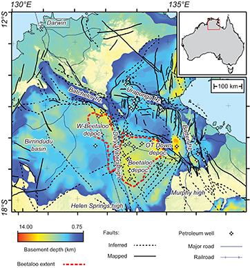
Figure 1.
Location of the study area. This basement depth map highlights the extent of the greater McArthur area and the location of the Beetaloo Sub-basin. Note the occurrences of the deepest depocenters in structurally complex areas and over the Beetaloo Sub-basin. (Data from Frogtech Geoscience, 2018; Beetaloo Sub-Basin extend from Williams, 2019). depoc. = depocenter; f.z. = fault zone; W-Beetaloo = western Beetaloo.

Figure 1.
Location of the study area. This basement depth map highlights the extent of the greater McArthur area and the location of the Beetaloo Sub-basin. Note the occurrences of the deepest depocenters in structurally complex areas and over the Beetaloo Sub-basin. (Data from Frogtech Geoscience, 2018