The AAPG/Datapages Combined Publications Database
AAPG Bulletin
Figure
AAPG Bulletin; Year: 2025; Issue: April DOI: 10.1306/03182524012
Return to Full Text
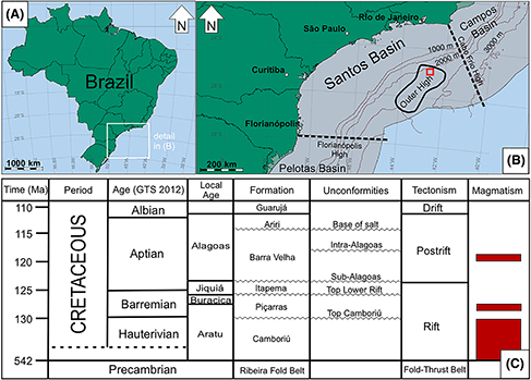
Figure 1. Santos Basin location and stratigraphic chart. (A) Map of Brazil with location of the Santos Basin at the southeastern coast of Brazil, inside the white square. Internal Brazilian state borderlines are in black. (B) Location of the studied oil field (red square) within the Santos Basin outer high (thick solid black line). The basin is limited by the Cabo Frio high on the northeast and the Florianópolis high on the southwest (dashed lines). (C) Stratigraphic chart of Santos Basin showing the position of the Barra Velha Formation, the main reservoir of the Brazilian pre-Salt fields. The Ariri Formation is formed by evaporites and is a regional seal for the oil fields within the Barra Velha Formation. Main magmatic events, tectonic phases, and unconformities are shown on the right side (modified from Moreira et al. [2007], Buckley et al. [2015], and Wright [2022]). GTS = geological time scale.
Figure 1. Santos Basin location and stratigraphic chart. (A) Map of Brazil with location of the Santos Basin at the southeastern coast of Brazil, inside the white square. Internal Brazilian state borderlines are in black. (B) Location of the studied oil field (red square) within the Santos Basin outer high (thick solid black line). The basin is limited by the Cabo Frio high on the northeast and the Florianópolis high on the southwest (dashed lines). (C) Stratigraphic chart of Santos Basin showing the position of the Barra Velha Formation, the main reservoir of the Brazilian pre-Salt fields. The Ariri Formation is formed by evaporites and is a regional seal for the oil fields within the Barra Velha Formation. Main magmatic events, tectonic phases, and unconformities are shown on the right side (modified from Moreira et al. [2007], Buckley et al. [2015], and Wright [2022]). GTS = geological time scale.