About This Item
- Full text of this item is not available.
- Abstract PDFAbstract PDF(no subscription required)
Share This Item
The AAPG/Datapages Combined Publications Database
GCAGS Transactions
Abstract
Abstract: River Morphology as an Indicator of the Baton Rouge Fault, Louisiana: Abstract
Abstract
Rivers that are in perfect equilibrium have smooth, concave-upward stream profiles and a steadily decreasing slope index (SL), (SL = slope × cumulative segment length). When subjected to tectonic changes, even subtle, they respond by changing their river pattern. The non-equilibrium condition is reflected in irregularities in the stream profile and by non-decreasing SL-indices. A gradient drop in the substratum causes a river to lose its energy. A meandering river may respond to a gradient drop by lowering its sinuosity, i.e. straighten, or by evolving into a braided river. If the river experiences a gradient increase in the substratum, on the other hand, its energy will increase. When the river gradients increases meandering rivers tend to increase their sinuosity, whereas braided rivers may change into a meandering pattern.
This study focuses on rivers that cross the Baton Rouge fault system, which consists of active growth fault segments located in southern Louisiana. The study area is well exposed on shaded relief maps derived from high-resolution (Digital Elevation Model) DEM data collected by LIgth Detection And Ranging (LIDAR) technology, which have removed the vegetation from the elevation data (Fig. 1). The region is therefore an excellent area for studies of alluvial river response to normal faulting.
The sinuosity changes, slope indices and longitudinal profiles for five rivers that cross the Baton Rouge fault system have been examined. The relief across the fault scarps varies between 0.75 and 4 meters, and the rivers cross the scarps in at nearly perpendicular angle. Irregularities in the stream profiles indicate that the rivers are generally not in equilibrium. This is also supported by changes in the downstream sinuosity (stream length/straight length) and by non-decreasing slope indices. The sinuosity peaks are typically located immediately downstream from fault scarps and are likely due to the gradient increase across the scarp. This is illustrated in the case of the Amite River shown in Figure 2. In areas where faults are overlapping and closely spaced, there are only small or no changes in sinuosity across scarps. This is likely due to interaction or linking of the faults such that each fault takes up a lesser portion of the deformation. Anomalies also occur in the vicinity of river confluences, which cause increases in both the sinuosity and the SL-index.
Channel sinuosity, slope index and stream profile are useful tools when locating or examining Gulf Coast faults. Furthermore, knowledge of patterns of displacement distribution across overlapping faults helps to determine whether faults are interacting in some manner.
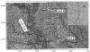 Figure 1.
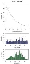 Figure 2. Amite River
Acknowledgments and Associated Footnotes
1 Department of Earth & Environmental Sciences, Tulane University, New Orleans, Louisiana 70118
2 Department of Earth & Environmental Sciences, Tulane University, New Orleans, Louisiana 70118
3 Department of Earth & Environmental Sciences, Tulane University, New Orleans, Louisiana 70118
This work is supported by an American Chemical Society-Petroleum Research Fund grant (# 38724-G8) to N. Dawers. We also acknowledge the State of Louisiana, in particular the Louisiana Oil Spill Coordinator's Office, and LSU for making LIDAR data in Louisiana publicly available.
Copyright © 2006 by The Gulf Coast Association of Geological Societies