About This Item
- Full text of this item is not available.
- Abstract PDFAbstract PDF(no subscription required)
Share This Item
The AAPG/Datapages Combined Publications Database
Southeast Asia Petroleum Exploration Society (SEAPEX)
Abstract
Abstract: New Airborne Gravity Gradiometry, Gravity and Magnetic Data over the Mannar & Cauvery Basins
Introduction
At the end of 2021, Bell Geospace acquired 14,000 line-kilometres of airborne full tensor gravity gradiometry (FTG), gravity and magnetic data over Sri Lanka’s offshore western Cauvery and Mannar basins (Figure 1). The lines were flown 1 km apart and ties 5 km. Water depth in the Cauvery basin doesn’t exceed 30 m and makes it a particularly suited area for FTG. This data provides new insights into the structural and tectonic history of the region, as well as on the hydrocarbon potential, particularly in Cauvery where modern 3D seismic is non-existent and exploration relies on vintage 2D lines.
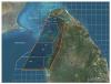 Figure 1. Air-FTG survey over the Cauvery and Mannar basins, flight lines are 1 km spaced and ties 5 km apart. PDASL exploration license blocks are indicated in white.
Basement and overlying basin shape complexity are clearly imaged. NE basin forming structures are displaced by both NNW and NW trending regional faults. Together with ENE and WNW trending fault patterns we evidence the complex development of the region providing insight on the prospectivity of these two important basin areas offshore Sri Lanka.
Geological background
The Geology of onshore Sri Lanka is primarily of Precambrian age, dominated by high-grade metamorphism. On the transition zone to the west, Miocene limestones outcrop and are present at shallow depths in Cauvery. Cauvery, Mannar and the Lanka basins to the South were formed during successive failed rift events, and associated rift-related subsidence, which were initiated during late Jurassic, at the break-up of East-West Gondwana and the Indian subcontinent moving apart from SE Africa. Later, in the early Cretaceous ~130 Ma ago, it is inferred that the partial separation of India and Sri Lanka resulted in a near 30 degree clockwise rotation which contributed to further opening. In addition to rift-subsidence, the early Cretaceous saw rifting induced volcanism which has been observed in the Barracuda and Pearl-1 wells in Mannar but the extent is still poorly mapped, yet critical for exploration.
Structural analysis of FTG gravity and magnetic data
Gravity anomalies reflect density contrasts within the subsurface. The gravity anomaly, Tz, and its tensor components (Tzz, Txx, Tyy, Txy, Txz, Tyz) respond differently to density distribution with depth. The gravity anomaly is more sensitive to deeper sources, associated with longer wavelength in the signal, whilst the gravity tensor components respond to shallower density contrasts, and produce shorter wavelengths. Both are combined to produce a full spectrum gravity anomaly, Tze, which takes advantage of both sensors strength to image the entire density distribution. In the Cauvery and Mannar basins, these are dominated by higher density rocks of the Precambrian basement at depth, and the Miocene limestones in the shallower subsurface, particularly within Cauvery.
The magnetic data detects basement and volcanic rocks with a high mafic content and, like, the gravity also show sensitivity to the deeper geology. The dominant fault trends evident from the magnetics are oriented ENE in the offshore over Cauvery, but more NE for the onshore and again over Mannar. A regional scaled set of NW oriented faults appear to displace the underlying basement fabric beneath both Cauvery and Mannar.
Both the gravity and tensor data show a strong NE-SW trend in the northern half of the survey over Cauvery and are associated with the rifting episodes, where highs and lows in the NE corner of the survey area are interpreted as being associated with horst and graben structures on the Precambrian basement. Regional structures between anomalies are also defined, where a WNW-ESE trend cross cuts the survey, showing a sense of displacement on the series of NE-SW trending anomalies.
Other regional fault trends include a NNW oriented system that impacts both Cauvery and Mannar. Two significant gravity lows are aligned along this regional trend at the northern end of Mannar. Their gravity expression points to the presence of deep synforms containing low-density material interpreted as sedimentary troughs. The corresponding tensor data reveals internal structural complexity defining a set of linear fault blocks forming the western part of Mannar and shallow pockets of low-density material within Cauvery.
These regional scaled NW & NNW structures show clear intersection with the ENE and NE oriented structures and together define the complex structuring within the Cauvery and Mannar basins. Localised potential for closed structural fault block presence are mappable in the tensor data; and where proximal to the primary trends, help delineate primary migratory pathways from deeper source rocks in Mannar to the south or Cauvery to the north.
Basement depth and volcanic layer
A basement depth map has been derived from depth profile analysis and 3D modelling of the gravity and magnetic data. Basement deepens from the onshore where it is near surface to depths from 2,500m to greater than 5,000m beneath Mannar. A volcanic layer is also identified at depths from 1,000m to 3,500m in the Mannar, but is not uniform.
The magnetic basement is generally shallow in the eastern and northern regions beneath Cauvery. Near shore, magnetic sources are very shallow, well within the sedimentary section. Iron-rich formations have been mapped both onshore Sri Lanka and southern India. These are interpreted as the source to the very short wavelength magnetic anomalies. Basement deepens beneath Mannar as predicted by the gravity data.
In addition to basin-forming events, Late Cretaceous basalt and diabase intrusive rocks intersect the clastic sedimentary section, especially in the Mannar Basin. Strong evidence for a basalt layer in the southern region of the survey area is supported by a significant EW trending magnetic anomaly. The overall higher magnitude in magnetic response for this volcanic layer sets it apart from the rather low amplitude magnetic anomaly character for the basement to the north and onshore.
Inversion of the FTG, gravity and magnetic data identifies depth and rock property relationships across the area and identify both high density and high susceptibilities for the interpreted volcanic sequences in Mannar. Basement is modelled otherwise with density and susceptibility ranges more akin of felsic / granitic composition.
Summary and Conclusions
FTG, gravity and magnetic data were acquired over Sri Lanka’s offshore, over the Cauvery and Mannar basins. The data image a complex suite of structural elements. The detailed survey resolves important structures which have not previously been imaged in public domain satellite derived or in marine gravity data. Both the Cauvery and Mannar basins have a set of NE-trending, basement controlled, first order crustal lineaments. These set up local areas of basement uplift and depression. The gradiometry data are particularly diagnostic for mapping local grabens and mini-basins which are of notable interest for exploration. Fault patterns pertinent to tracking potential migratory pathways and defining potential for closed structures presence are easily mapped.
Inversion of the magnetic and both the FTG and gravity datasets identifies basement depth and composition.
Acknowledgments and Associated Footnotes
1 Colm Murphy: Bell Geospace Ltd,; [email protected]
2 Richard Farnell: Bell Geospace Ltd,
3 Michal Ruder: Wintermoon Geotechnologies, Inc.
4 Gaud Pouliquen: Bell Geospace Ltd,
5 Chris Bellamy: Bell Geospace Ltd,
Colm Murphy is Chief Geoscientist with Bell Geospace, the leading providers of FTG Gravity gradiometry data solutions to the industry. He leads the team that assesses FTG’s application on projects, designing the work programmes and delivering optimal solutions leading to informed geological decisions ranking areas for exploration potential. Colm is both a geologist and geophysicist specialising in gravity, magnetics and FTG data workflows for efficient exploration. He holds a PhD from the University of Galway, Ireland and 30 years industry experience working FTG, gravity and magnetic data solutions for Energy, Geothermal and Mineral exploration projects world-wide.
Copyright © 2023 by Southeast Asia Petroleum Exploration Society (SEAPEX)