The AAPG/Datapages Combined Publications Database
AAPG Bulletin
Figure
AAPG Bulletin; Year: 2021; Issue: October DOI: 10.1306/04232120046
Return to Full Text
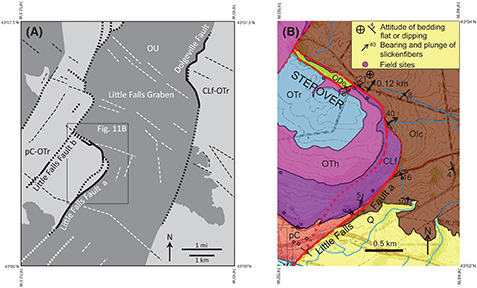
Figure 11.
(A) Simplified geologic map of the Little Falls quadrangle (location of (A) shown in Figure 2 as dashed white box labeled “Fig. 11A”). Heavy, solid black lines indicate known fault locations, tics on downthrown side; heavy black or white short-dashed lines indicate inferred fault locations. Thin black or white long-dashed lines indicate topographic lineaments. Black box labeled “Fig. 11B” indicates approximate location of (B). Figure after Agle et al. (2005, 2006a, b), Jacobi et al. (2005). (B) Geologic map of fault stepover area of Little Falls Fault. Location of map is shown by labeled box in (A). Figure after Agle et al. (2005), Jacobi et al. (2005). Red lines = fault traces; solid red lines = less than 15 m uncertainty; dashed = approximate; dotted = inferred; CLf = Cambrian Little Falls Dolostone; ODo = Ordovician Dolgeville Formation of the Utica Group; OIc = Ordovician Indian Castle Formation of the Utica Group; OTh = Ordovician Tribes Hill Formation; OTr = Ordovician Trenton Group; OU = Ordovician Utica Group; pC-OTr = Proterozoic rocks and overlying section of Cambrian Potsdam Sandstone through Ordovician Trenton Group (the Cambrian–Ordovician Great American carbonate bank of Landing, 2012); Q = Quaternary.
Figure 11. (A) Simplified geologic map of the Little Falls quadrangle (location of (A) shown in Figure 2 as dashed white box labeled “Fig. 11A”). Heavy, solid black lines indicate known fault locations, tics on downthrown side; heavy black or white short-dashed lines indicate inferred fault locations. Thin black or white long-dashed lines indicate topographic lineaments. Black box labeled “Fig. 11B” indicates approximate location of (B). Figure after Agle et al. (2005, 2006a, b), Jacobi et al. (2005). (B) Geologic map of fault stepover area of Little Falls Fault. Location of map is shown by labeled box in (A). Figure after Agle et al. (2005), Jacobi et al. (2005). Red lines = fault traces; solid red lines = less than 15 m uncertainty; dashed = approximate; dotted = inferred; CLf = Cambrian Little Falls Dolostone; ODo = Ordovician Dolgeville Formation of the Utica Group; OIc = Ordovician Indian Castle Formation of the Utica Group; OTh = Ordovician Tribes Hill Formation; OTr = Ordovician Trenton Group; OU = Ordovician Utica Group; pC-OTr = Proterozoic rocks and overlying section of Cambrian Potsdam Sandstone through Ordovician Trenton Group (the Cambrian–Ordovician Great American carbonate bank of Landing, 2012); Q = Quaternary.