The AAPG/Datapages Combined Publications Database
AAPG Bulletin
Figure
AAPG Bulletin; Year: 2021; Issue: October DOI: 10.1306/04232120046
Return to Full Text
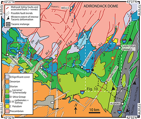
Figure 2.
Geology map of the Mohawk Valley region, New York State, that displays the Mohawk Valley faults and associated faults. These faults sustained significant motion during the Taconic Orogeny. (Approximate location of Figure 2 shown as the green box in Figure 1). Geology generally from US Geological Survey website (US Geological Survey, 2016) and from Fisher (1980). Taconic mélange, Taconic allochthon, and Taconic intense deformation bands from Kidd (in Jacobi et al., 2016). Faults modified from Cushing and Ruedemann (1914), Fisher (1980), Bradley and Kidd (1991), Kidd et al. (1995), Hayman and Kidd (2002a, b), Cross et al. (2004), Agle et al. (2005, 2006a), and Jacobi et al. (2005), and generally follow those in O’Hara et al. (2017). Possible faults (indicated by black dashed outline of semitransparent fill) are modified from Jacobi (2002) and are based primarily on lineaments, several of which are coincident with known faults to the north. Red and yellow star indicates approximate location of core discussed in text. Large numbers in italics (1–5) indicate locations of grabens discussed in text. Black solid circle on Hoffmans Fault indicates location of kinematic indicators displayed in Figure 15. Labeled, white dashed boxes indicate locations of Figures 10 and 11A. Figure modified from Jacobi and Ebel (2019). Fault name abbreviations: Do = Dolgeville; E-G = East Galway; Eph = Ephrata; E-S-A = East Stone Arabia; Fo = Fonda; G-L = Galway Lake; Ho = Hoffmans; Hrk = Herkimer; L-F = Little Falls; Man = Manheim; M-C = Mother Creek; No = Noses; S-M = Saratoga-McGregor; Sp = Sprakers; T-H = Tribes Hill; W-G = West Galway; System name abbreviations: C = Cambrian; C-O = Cambrian–Ordovician; O = Ordovician; Q = Qal (Quaternary alluvium).
Figure 2. Geology map of the Mohawk Valley region, New York State, that displays the Mohawk Valley faults and associated faults. These faults sustained significant motion during the Taconic Orogeny. (Approximate location of Figure 2 shown as the green box in Figure 1). Geology generally from US Geological Survey website (US Geological Survey, 2016) and from Fisher (1980). Taconic mélange, Taconic allochthon, and Taconic intense deformation bands from Kidd (in Jacobi et al., 2016). Faults modified from Cushing and Ruedemann (1914), Fisher (1980), Bradley and Kidd (1991), Kidd et al. (1995), Hayman and Kidd (2002a, b), Cross et al. (2004), Agle et al. (2005, 2006a), and Jacobi et al. (2005), and generally follow those in O’Hara et al. (2017). Possible faults (indicated by black dashed outline of semitransparent fill) are modified from Jacobi (2002) and are based primarily on lineaments, several of which are coincident with known faults to the north. Red and yellow star indicates approximate location of core discussed in text. Large numbers in italics (1–5) indicate locations of grabens discussed in text. Black solid circle on Hoffmans Fault indicates location of kinematic indicators displayed in Figure 15. Labeled, white dashed boxes indicate locations of Figures 10 and 11A. Figure modified from Jacobi and Ebel (2019). Fault name abbreviations: Do = Dolgeville; E-G = East Galway; Eph = Ephrata; E-S-A = East Stone Arabia; Fo = Fonda; G-L = Galway Lake; Ho = Hoffmans; Hrk = Herkimer; L-F = Little Falls; Man = Manheim; M-C = Mother Creek; No = Noses; S-M = Saratoga-McGregor; Sp = Sprakers; T-H = Tribes Hill; W-G = West Galway; System name abbreviations: C = Cambrian; C-O = Cambrian–Ordovician; O = Ordovician; Q = Qal (Quaternary alluvium).