The AAPG/Datapages Combined Publications Database
AAPG Bulletin
Full Text
![]() Click to view page images in PDF format.
Click to view page images in PDF format.
AAPG Bulletin, V.
DOI: 10.1306/09142221207
Exploration benchmarking to establish the potential of two hydrocarbon plays in the Pelotas and Punta del Este Basins, offshore Uruguay
David A. Pollitt1 and Shaoqing Sun2
1C&C Reservoirs, Houston, Texas; [email protected]
2C&C Reservoirs, Houston, Texas; [email protected]
Abstract
This study uses minimal prior information to place into context the exploration potential for two prospects that lack well information in the Pelotas and Punta del Este Basins, offshore Uruguay. Prospect A is representative of a typical prospect within the Cretaceous turbidite play, interpreted to be charged by marine Aptian shales, with an Albian sandstone reservoir sealed by Cenomanian shales during a regional transgression, trapped in a structural-stratigraphic trap. Prospect B is representative of a typical prospect within the Cretaceous shallow-marine sandstone play, charged by Barremian lacustrine shales into Maastrichtian reservoirs, sealed by transgressive Paleocene shales, in stratigraphic pinch-outs and/or subunconformity truncation traps.
Prospects A and B were benchmarked using four filters that restricted analogues to similar hydrocarbon type, reservoir age, depositional environments, and trapping mechanisms. The resulting analogue population can be used to reduce uncertainty and quantify the potential of the prospects. Prospect A’s interpretation is on the high side of the analogue distribution since both the productive area and original oil in place do not exceed the 10th percentile of observed data of the analogue data set. Significant uncertainty exists for prospect B as currently defined, but analysis of the context of the play and prospect suggests that the appropriate conditions exist to be a viable play.
This workflow can be used in a variety of low-data situations to increase confidence in interpretation and decrease risk by narrowing uncertainty. This study demonstrates that methodical and critical application of analogues can quantitatively augment available data with information based on historical performance, instead of relying on subjective and qualitative individual and team experience of similar analogues.
INTRODUCTION
The aim of this study is to objectively quantify the hydrocarbon resource potential of the Uruguayan Pelotas and Punta del Este Basins using analogue benchmarking of prospects in the two primary plays. These plays have been identified by prior work as the most likely to be successful and have prompted the only offshore drilling in recent years (Rodriguez et al., 2019). The intent of this study is not to define the chance of success for individual prospects or plays, but rather to place previous work that describes the hydrocarbon potential of offshore Uruguay in the context of similar prospects and plays worldwide. This type of analysis serves as quality assurance on the accuracy of technical predictions, including highlighting potential gaps, issues, and biases. This paper summarizes findings from ongoing research to quantify predictions and outcomes on a parameter, volume, and uncertainty basis.
Analogue Benchmarking
Analogue methods play a significant role in both the assessment of resource potential and as a basis for reserves estimation, particularly during exploration and appraisal phases of an asset’s life, when information from direct measurement is limited and typically at a minimum (Sidle and Lee, 2010). However, frequently, analogue analysis is a qualitative process that can depend heavily on individual, team, and company experience (Hodgin and Harrell, 2006). Consequently, there is little formalization and consistency of application, and this can result in both bias and an absence of analytical repeatability (Milkov, 2015). Further, this subjectivity inherent to the process limits the capacity to learn from best practices and mistakes (Milkov and Samis, 2020). This is in direct contrast to other aspects of the exploration and appraisal workflow, where much effort has been applied to imposing objectivity and removal of bias, particularly in the estimation of resource and the calculation of reserves (Society of Petroleum Engineers, 2018).
In situations where prior information is limited, such as predrill exploration or even preseismic exploration, geoscientists and engineers have more leeway in developing permissible alternatives. Such alternatives may be predicated solely on limited information, such as the age of the target formation, tectonic setting, and likely lithology based upon paleogeography and basin dynamics. As more information becomes available, the number and variation of permissible alternatives decreases. This reduction in possibility and uncertainty commonly decreases inversely with the number of well penetrations of the reservoir throughout a field’s life. The use of structured analogue benchmarking early in a field’s life can reveal new or previously missed opportunities for value creation and increase the chances for a favorable outcome without any appreciable cost or risk in the application of the method. More broadly, systematic benchmarking of trends, such as portfolios of reservoirs or plays, is vital to improving predictive concepts through the quantitative identification of common themes of success and causes of failure (Milkov, 2021).
As data on a prospect or asset increase, analogues provide a valuable mechanism for quality assurance of assumptions throughout the exploration and production lifecycle (Sun et al., 2021). Initial technical work and data collection can be tested against the efficacy of methods employed by analogues, helping to frame a problem and identify likely critical risks and uncertainties. As technical understanding matures, benchmarking can be used to calibrate a prospect’s or asset’s potential, both assisting in the selection of parameters, and providing the basis for their use as inputs to volumetric assessments. Finally, statistics derived from appropriate use of analogue benchmarking is a powerful method of quality assurance, providing a key reality check for important and costly decisions (Milkov, 2020).
Use of Analogues in Frontier Exploration
Fundamental geoscience in the form of interpretation and analysis is commonly the basis for identifying and characterizing resource potential during exploration prior to drilling. Historical drilling results can be used to test the ideas and techniques used by geoscientists during risking and assessment. However, in frontier exploration where prior drilling information is limited, such as offshore Uruguay, accurate assessments cannot be formed by nearby drilling alone, and analogous information must be used from beyond the local area.
The complementary relationship of fundamental geoscience analysis combined with global and local calibration to analogue data has long been recognized and implemented, albeit commonly in a qualitative and subjective manner. Petroleum geoscientists and engineers regularly make predictions about plays, prospects, reservoirs, potential hydrocarbon recovery, and well performance. Typically, this is achieved by applying concepts and workflows to subsurface data sets. The veracity of the interpretation made by geoscientists is commonly only realized with the drilling of an exploration well. This then provides information on how useful the applied technology was and how complete the understanding of the subsurface is. Analogue benchmarking, used appropriately, can provide a valuable form of quality assurance of assumptions, without the expense of an exploration well. If the proposed parameters for a prospect are beyond the range of similar prospects worldwide, then doubt should form as to the likelihood of the assessment being accurate. At the least, this kind of analysis forces detailed quantification of assumptions and an explicit assessment of their probability. With enough accurate analogue data, trends and opportunities can be understood on both a local and global basis (Milkov and Navidi, 2020). Given a suitably large sample size, this data can further be used to calibrate concepts and tools, as well as provide a basis for future predictions.
Exploration for new hydrocarbon resources requires confidence that a new well will be successful. This confidence is derived from quantitative and semiquantitative sources, such as direct and indirect measurement of the subsurface, and qualitative sources, such as the experience of the geoscientists and engineers involved. Although established methods have emerged for establishing the risk and uncertainty associated with quantitative sources, it is typically more difficult to quantify with any certainty the degree of risk and uncertainty derived from qualitative sources. Frequently, overconfidence results in the risk associated with defining a too-narrow range of outcomes, and an unrepresentative chance of success. Recent work has focused on reducing conscious and unconscious bias in exploration and production decision-making (Milkov, 2015, 2021; Peel and White, 2016). The rigorous and unbiased application of analogue benchmarking, when used appropriately and with context provided by prior geological information and experience, is an effective tool at eliminating bias and for the examination of assumptions. It prompts the consideration of viable alternatives and scrutinizes alternate routes to creating value through objective characterization, leading to better decisions.
Benchmarking predrill assumptions against the results observed in a global analogue data set should form an integral part of prospect maturation workflow. This information can enhance the knowledge of groups of subject-matter experts that may be prone to cognitive bias (Baddeley et al., 2004; Rudolph and Goulding, 2017). Significant variation of the benchmarked parameter from the average of analogues, or wide ranges themselves, are permissible but should be evaluated critically. Comparisons made on an analogue basis can be used to better identify, evaluate, and prioritize opportunities by making clear where bias has led to an over- or underestimation of uncertainty, risk, and volumes. The trends observed in the analogue data set, although not a guarantee of future performance for any individual field, represent a statistically significant sample to understand the probability distribution of equivalent fields, and can therefore be considered representative of future outcomes on an aggregate basis. A further advantage of using a robust database of analogues is that there is no dependency between the observed data and the comparator data set, which could exist when using local analogues exclusively.
Geological Setting
The Punta del Este Basin and the southern part of the Pelotas Basin, both offshore Uruguay, and part of the South Atlantic volcanic passive margin, are relatively unexplored compared with nearby basins on the South Atlantic margin (Figure 1). Conjugate margin rift basins of West Africa and Brazil were initially formed by extension during the Early Cretaceous, as the South American plate began to separate and rotate clockwise from Africa (Stoakes et al., 1991). Within the present-day Brazilian sector, 20 exploration wells were drilled in the Pelotas Basin prior to 2017 (Conti et al., 2017). In contrast, the only well drilled to date in the Uruguayan sector of the Pelotas Basin was the Raya-X1 well in 2016, whereas two wells (Lobo-1 and Gaviotin-1) have been drilled in the Uruguayan shallow-water part of the offshore Punta del Este Basin in 1976 (Morales et al., 2017a; Rodriguez et al., 2019).
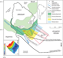 Figure 1. Map depicting the extent of the Pelotas and Punta del Este Basins (modified after Soto et al., 2011), the study area, and the line of sections for Figures 2 and 3. Depth map (inset, lower left) depicting top basement courtesy of Administración Nacional de Combustibles, Alcohol y Pórtland.
Despite the paucity of well data in an area of more than 130,000 km2, numerous seismic surveys have allowed detailed study of the basin evolution (Preu et al., 2012; Rossello et al., 2018) and sedimentary sequence (Viera Honegger et al., 2018; Kirby et al., 2021). Major stratigraphic unconformities have been recognized along with primary structural elements of deformation. Prerift, synrift, and the Cretaceous postrift sedimentary sequences differ significantly between the two basins, whereas the Cenozoic postrift is more homogeneous (Morales et al., 2017b; Viera Honegger et al., 2018).
Prerift Gondwanan Paleozoic sediments are preserved as relicts after uplift and subsequent denudation during the late Hercynian Orogeny. Two synrift stages have been identified in the Punta del Este Basin, whereas only the later stage is apparent in the Pelotas Basin. During the initial synrift, in the Late Jurassic to earliest Cretaceous, half grabens bounded by northwest-southeast faults developed. During later extension in the Early Cretaceous, antithetic faulting developed parallel to the margin in a northeast-southwest orientation, resulting in the development of smaller half grabens (Soto et al., 2011; Steventon et al., 2019).
In the Pelotas Basin, the synrift megasequence fills in half graben structures in the proximal part of the basin. Distally, this megasequence is characterized by seaward-dipping reflectors (SDRs) (Fontana, 1990). The postrift megasequence is dominated by marine sedimentation separated into shelfal, transgressive, and regressive sequences by Bueno et al. (2007). This postrift sedimentation is dominated by a sedimentary wedge that thickens seaward (Paton et al., 2017). In the Punta del Este Basin, Cretaceous postrift strata are primarily deposited in a regressive systems tract, with periodic progradational wedges (Conti et al., 2017; Viera Honegger et al., 2018). This contrasts with the Pelotas Basin, where sedimentation is primarily within an aggradational–retrogradational systems tract (Figure 2). The Cenozoic postrift interval is retrogradational in both basins (Conti et al., 2017; Morales et al., 2017b; Viera Honegger et al., 2018).
 Figure 2. Representative seismic line indicating the major stratigraphic intervals associated with different tectonic regimes (Conti et al., 2017). The seismic polarity is Society of Exploration Geophysicists standard. The line of this section is shown in Figure 1. Sea-floor bathymetry after Becker et al. (2009). Seismic data courtesy of the Administracion Nacional de Combustibles, Alcohol y Portland and ION Geophysical. SDR = seaward-dipping reflector.
Significant attention has been afforded in recent years to the hydrocarbon potential of offshore Uruguay (e.g., Saunders et al., 2013; Penn et al., 2016). Recent high-quality seismic data have identified multiple possible reservoirs, traps, source rocks, and direct hydrocarbon indicators in the basin (Morales et al., 2017a, 2020; Rodriguez et al., 2019).
Seismic interpretation has led to several workers proposing deltaic processes as the most likely source of potential plays (Hernández-Molina et al., 2016; Conti et al., 2017; Morales et al., 2017a). Many likely reservoirs were deposited by common mechanisms in passive-margin, mixed-source deltaic systems, including those of basins in the West African conjugate margin (Beglinger et al., 2012). This includes highstand sands deposited within prograding clastic wedges, shelf-edge sequences deposited during aggradation, and lowstand slope fan sands.
The onshore Parana Basin has been used as a local analogue of a proven petroleum system equivalent to prerift offshore plays (Conti et al., 2017). Half grabens of the synrift have been interpreted as possibly containing lacustrine source rocks (Scaife and Ferro, 2011). The SDRs within the Cretaceous sequence have been interpreted as a possible reservoir interval (Conti et al., 2017), benefitting from a potentially widespread Aptian–Albian source rock, with the main risk being the presence of high-quality reservoirs. Analogous reservoirs within the proven petroleum system of the Orange Basin (Namibia) are aeolian sandstones interbedded with volcanic rocks (Conti et al., 2017; Samakinde et al., 2021). In the postrift megasequence, Conti et al. (2017) identified three potential marine source rocks related to maximum flooding surfaces. This study also highlights multiple siliciclastic reservoirs within the postrift megasequence and regional shale seals deposited during maximum flooding events in the Cenomanian–Turonian, Paleocene, and Miocene. Conti et al. (2017, p. 23) conclude that the “post-rift petroleum systems present a higher hydrocarbon potential compared to those of the pre-rift and syn-rift megasequences.”
Most of the traps identified in these basins are stratigraphic traps, including pinchout traps, turbidite sedimentary bodies, and channels. Migration pathways are noted as a critical risk (e.g., Conti et al., 2017), but several studies note the presence of significant throughgoing faults associated with postrift tectonism that may act as migration pathways for Lower Cretaceous source rocks to charge postrift Cretaceous reservoirs, and Paleocene source rocks, if mature, to charge Cenozoic reservoirs (Franke et al., 2007; Tomasini et al., 2011; Creaser et al., 2017).
METHODOLOGY
Primary Data
The primary data for this study were provided by the Administración Nacional de Combustibles, Alcohol y Pórtland (ANCAP), Uruguay. The ANCAP is the state-owned company with responsibility for Uruguayan hydrocarbon resources. The ANCAP provided data and interpretation for one anonymized undrilled exploration prospect for each of the two plays to be analyzed: prospect A and prospect B (Figure 3). The identified prospects were specifically selected to be representative of the play in general, and not represent an extreme for any key parameter (Rodriguez et al., 2019).
 Figure 3. Schematic cross sections indicating notional position of petroleum system elements within an idealized shelf–basin transect across (A) prospect A and (B) prospect B (modified after Gristo et al., 2021). Interpretation by the Administracion Nacional de Combustibles, Alcohol y Portland. The line of the section is shown in Figure 1.
Prospect A is representative of a typical prospect within the Cretaceous turbidite play, interpreted to be charged by marine Aptian shales, with an Albian sandstone reservoir sealed by Cenomanian shales during a regional transgression (Figure 3A). The trapping mechanism is envisaged to be a combination structural-stratigraphic trap related to the channels and depositional geometry of the turbidite system and postrift throughgoing faults (Figure 4).
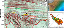 Figure 4. Northwest-southeast dip seismic line across prospect A showing the geometry of the mapped stratigraphic pinchout trap (Gristo et al., 2021). Maps to the right show the study area (top) and the prospect outline (bottom). The seismic polarity is Society of Exploration Geophysicists standard. The black lines on the seismic data are faults (interpretation by Administracion Nacional de Combustibles, Alcohol y Portland). The black lines on the upper inset map are exploration block boundaries. The red line is the line of section. The thick black line on the lower inset map corresponds to the extent of the interpreted amplitude versus offset anomaly displayed on the seismic cross section (yellow area that is arrowed on the seismic cross section), and the thin lines are depth contours of the seafloor. Seismic data and interpretation courtesy of the Administracion Nacional de Combustibles, Alcohol y Portland. OFF = offered exploration block; TWT = two-way traveltime.
Prospect B is representative of a typical Cretaceous shallow-marine sandstone play. It is interpreted to be charged by Barremian lacustrine shales into Maastrichtian reservoirs (Figure 3B). The different charge model is based on the more proximal setting of the trapping geometries, overlying half grabens formed from earlier rifting, which are postulated to be “kitchens” of hydrocarbon maturation. Prospect B is interpreted to be sealed by transgressive Paleocene shales. Stratigraphic pinch-out and/or subunconformity truncation are interpreted to be the main trapping mechanisms (Figure 5). These can be formed in several ways, including differential compaction and also tectonic inversion related to the uplift of the Polonio high, which separates the Punta del Este and Pelotas Basins (Morales et al., 2017b).
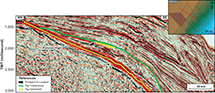 Figure 5. Northwest-southeast dip seismic line across prospect B showing the geometry of the mapped subunconformity truncation trap (Gristo et al., 2021). The inset map shows the study area and the line of section (heavy red line). The seismic polarity is Society of Exploration Geophysicists standard. Seismic data and interpretation courtesy of the Administracion Nacional de Combustibles, Alcohol y Portland. TWT = two-way traveltime.
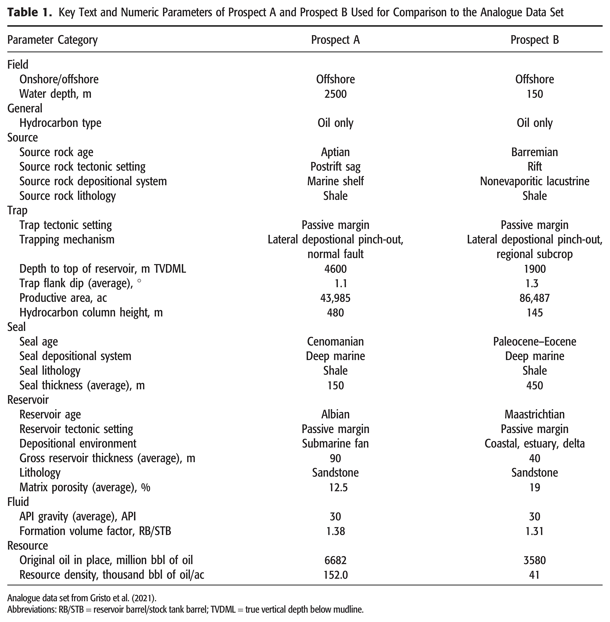
Predrill assumptions for prospect A and prospect B include geologic and engineering parameters related to each hydrocarbon play element, such as hydrocarbon type, API gravity, formation volume factor (FVF), gross reservoir thickness, matrix porosity, depth to top of reservoir, trap flank dip, productive area, and hydrocarbon column height. Derived parameters, in that they are dependent on other factors such as original oil in place (OOIP) and resource density, were also calculated and used in this study. Contextual information, such as tectonic setting, trapping mechanism, geologic age, and depositional environment, for each petroleum system element were also included. Crucially, the provided data is primarily derived from indirect measurements within the study area, because direct measurement from wells is limited. The data used for comparison to the analogue data set are given in Table 1.
Analogue Database
The analogue data used by this study comes from a proprietary database of global reservoirs, compiled using more than 50,000 open-domain publications. This data set includes samples from every significant petroleum basin, play, and reservoir type. The information used to compile this analogue knowledge base is standardized and parameterized into approximately 400 variables for each reservoir. This parameterization is supported using detailed field and reservoir case studies. Each field case study details how and why the prospect was drilled and the basin genesis and source rock, and contains a detailed description of the structure and trap definition, reservoir characteristics, and fluid properties. It also details resources as well as human factors in field development, including development strategy, reservoir management practices, and improved recovery techniques applied and their outcomes. Using a holistic classification scheme allows consistent and appropriate comparisons to be made on an equal basis between analogues—colloquially, “comparing apples to apples” (Sun et al., 2021).
Benchmarking Workflow
The workflow used herein attempts to provide an accurate, objective, and repeatable way of conducting analogue analysis and benchmarking. The workflow consists of five key steps: (1) define problems and objectives, (2) consistently document knowledge, (3) choose relevant analogues, (4) benchmark targets or characterize analogues, and (5) identify best practices (Figure 6). Problems of differing nature and for different objectives require different sets of analogues. The workflow advocates starting with a broad set of parameters to find a wide range of analogues, then narrow the selection as appropriate to focus on the specific critical issue (Sun and Pollitt, 2022). This workflow is intended to introduce a simple, practical, and effective solution to removing the bias that currently exists in the use of analogue information.
 Figure 6. Flowchart describing key steps in the analogue benchmarking workflow used in this study, along with descriptions of critical activities during each step.
Analysis was conducted by comparing predrill assumptions for prospect A and prospect B to outcomes from analogous reservoirs on a parameter basis. The identified analogue populations generally have at least 30 data points to ensure comparisons are statistically significant and avoid bias caused by low sample size. This has particular importance when examining parameters that exist at the extreme of the distribution, such as very high net-to-gross reservoirs or reservoirs with a very large trapping container.
Analogue Selection
Thirty-three analogous reservoirs were identified for prospect A using three conditions: (1) offshore oil reservoirs, (2) submarine fan depositional environment of Cretaceous and Cenozoic age, and (3) specific stratigraphic trapping mechanisms (lateral depositional pinch out, clastic macroform, and erosional trough-fill). The analogue reservoirs identified according to these criteria, along with key text and numeric parameters used for benchmarking analysis are summarized in Table 2.

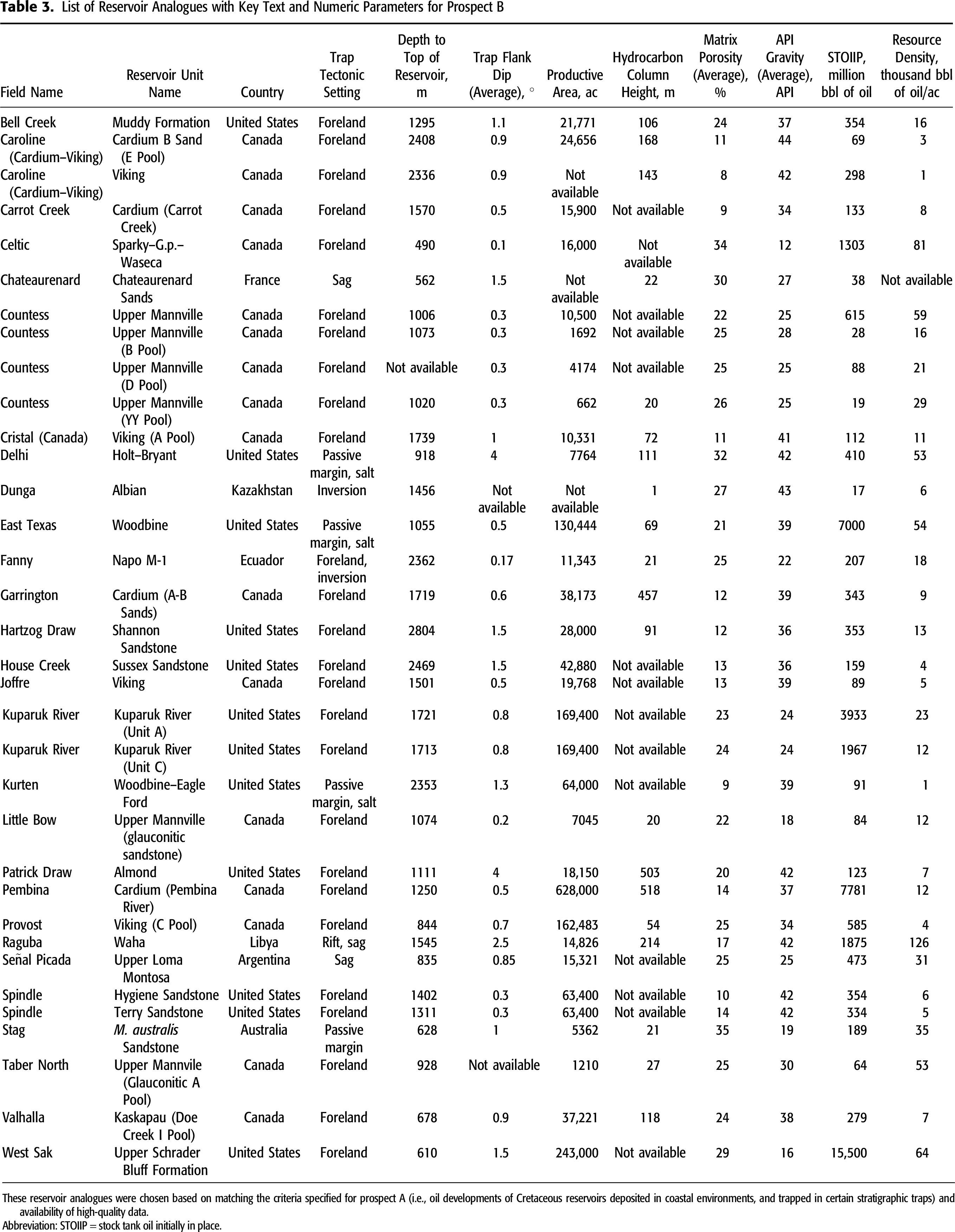
Thirty-four analogous reservoirs were identified for prospect B using three conditions: (1) onshore or offshore oil reservoirs, (2) coastal depositional environment of Cretaceous age (shoreline-shelf, estuary, delta), and (3) specific stratigraphic trapping mechanisms (lateral depositional change, subunconformity truncation, onlap onto erosional surface, erosional trough-fill). The analogue reservoirs identified according to these criteria, along with key text and numeric parameters used for benchmarking analysis are summarized in Table 3.
For both prospects, condition 1 restricts the search to the relevant fluid phase. Condition 2 restricts the search purely to geologically similar types of reservoirs constrained by depositional environment and reservoir age. Condition 3 constrains the trapping conditions to those envisaged by the play concept.
Eight key parameters were identified and used to benchmark prospect A and prospect B. These include parameters critical to assessing hydrocarbon in place, such as matrix porosity, fluid properties such as API gravity and FVF, and parameters critical to the trapping geometry such as hydrocarbon column height and trap flank dip. The OOIP, productive area, and resource density were also used as parameters for benchmarking. Several key measures are used to characterize the distribution and provide statistical context to the position of the benchmarked prospects. They include the mean, median, and probabilities of exceedance of percentiles (P10, P50, and P90). By studying the resulting analogue population, observations can then be made about the likely parameter distribution, uncertainty, and ultimately, the potential of the identified prospect based on similar analogues discovered elsewhere in the world.
RESULTS
Prospect A: Cretaceous Turbidite Reservoir Play
Benchmarking results are presented in terms of the relation of the benchmarked parameter from prospect A relative to the distribution from analogous reservoirs, expressed as a percentile (Table 4). Minimum and maximum values for the analogue data set are given, along with the geometric mean.

A convenient way to understand the full range of uncertainty for the studied parameters is to examine where the prospect falls in the statistical distribution of selected analogues (percentile). Otis and Schneidermann (1997) and Otis and Haryott (2010) described a methodology to determine an appropriate P10/P90 (P10–P90 ratio) for parameter distributions as a guideline in quantifying uncertainty. If a P-value for a given parameter for the prospect is at an extreme of the distribution (less than the P90 or greater than the P10), then this can be considered unlikely as it is rarely observed amongst the analogue population and it is therefore prudent to test the validity of assumptions for that parameter value.
The values from prospect A for trap flank dip, API gravity, and FVF are at the 84th, 50th, and 30th percentile, respectively. Benchmarking in this case indicates that these are reasonable assumptions given the limited knowledge about the petroleum system.
Matrix porosity for prospect A is interpreted by the ANCAP as 12.5%, where matrix porosity is defined as the P50 value for porosity at the burial depth of the reservoir using porosity–depth relationships for sandstone reservoirs (Ehrenberg and Nadeau, 2005; Rodriguez et al., 2019). Based on the analogue population, the matrix porosity value for prospect A (12.5%) is at the 100th percentile, meaning all analogue reservoirs exceed this value. Based on empirical burial-depth trends alone, a case can be made that the interpretation of porosity is underestimated in prospect A because empirical burial-depth trends do not account for situations of overpressure in reservoirs (Figure 7A). Unless there are specific reasons to expect a degradation of the intrinsic depositional porosity of the reservoir and combined with the possibility of overpressure in prospect A, it would be reasonable to assume a higher porosity, or at least a wider possible porosity range, for prospect A that more closely follows the analogue porosity distribution trend in Figure 7A.
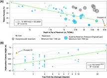 Figure 7. Graphs showing data from submarine-fan stratigraphic trap analogues and prospect A. (A) Burial-depth relationship for analogous reservoirs with normal pressure gradient (overpressured analogues include Mars, Who Dat, Pompano, and Ram-Powell fields in United States and Erha field in Nigeria). (B) Hydrocarbon column height versus trap flank dip. Boundary lines are projected on the same plane as the trend line based on the furthest minimum and maximum analogue outliers. Prospect A lies above the maximum analogue boundary line. k = thousand; R2 = coefficient of determination; TVDML = true vertical depth below mudline.
The productive area of prospect A was mapped from seismic data as the maximum possible closure (Gristo et al., 2021). Based on both the productive areas and OOIP of samples in the analogue population, prospect A lies at the 3rd percentile, and indicates that the productive area is potentially overestimated. It is likely, based on these data, that the true productive area is therefore smaller, and caution should be applied in determining productive area (and OOIP) primarily from seismic data.
Further consideration to the relationship between hydrocarbon column height and trap flank dip is given in Figure 7B. Based on the trends observed in analogues, careful thought should be given to the most likely hydrocarbon column height for prospect A. The modeled height (480 m) sits close to the P10 from analogues; however, analogue benchmarking suggests that this is not likely for a prospect with a low trap flank dip (meaning the trap would be spread over an anomalously large area compared to analogues). This further reiterates that, based on analogues, the overall trapping geometry is likely to be smaller than currently modeled. This is likely to have positive economic implications because any potential development will be concentrated in a smaller area.
Both the trap tectonic setting and trapping mechanism of prospect A are compatible with those of submarine-fan analogues. The most common tectonic setting for the submarine-fan lateral depositional pinchout trap development is passive margin, followed by salt and sag (Figure 8A).
 Figure 8. Histogram depicting the frequency of occurrence for trap tectonic setting. (A) Prospect A is dominated by passive margin, salt, and sag. (B) Prospect B is dominated by foreland basin analogues.
Prospect B: Cretaceous Shallow-Marine Sandstone Pinchout Trap Play
Benchmarking results are presented in terms of the relation of the benchmarked parameter from prospect B relative to the distribution from analogous reservoirs, expressed as a percentile (Table 5). From these results, an initial observation can be made that all eight parameters for prospect B fall within the P90–P10 range of analogues and therefore suggest that the interpretation and assumptions made for this prospect are broadly reasonable. Porosity in prospect B is defined as the P50 value at the burial depth of the reservoir using porosity–depth relationships for sandstone reservoirs (Ehrenberg and Nadeau, 2005; Rodriguez et al., 2019). This results in a reasonable assumption for porosity at the P62 of analogous reservoirs (Table 5). Given the prospect’s trap flank dip (1.3°), both the original hydrocarbon column height and productive area are reasonable (Figure 9).
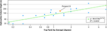 Figure 9. Hydrocarbon column height versus trap flank dip crossplot for the shallow-marine sandstone stratigraphic trap analogues. Prospect B follows the trend line. Blue circles indicate parameter values from analogue reservoirs. R2 = coefficient of determination.
Despite the interpreted thick top seal for prospect B, benchmarking by analogues suggests seal is the critical risk for this prospect. Prospect B is interpreted to be a Late Cretaceous stratigraphic pinchout trap sealed by transgressive Paleocene shales. During the Late Cretaceous and Paleocene the Pelotas and Punta del Este Basins were passive margin basins with broadly quiescent tectonics. However, most coastal, shallow-marine sandstone stratigraphic traps occur in foreland basins since they require a reversal of regional dip in response to thrust tectonic events to create an effective updip seal (Figure 8B). In a passive margin, this situation typically does not exist because uniform subsidence into the basin prevents the inversion necessary to generate stratigraphic traps. Stratigraphic traps in passive margin settings for this play concept occur much less frequently (Figure 8B), with only four analogous examples in the data set (Stag field, Australia, and Delhi, East Texas, and Kurten fields, United States). These fields require combination trapping with either a structural component (e.g., Stag field) or regional truncation of strata (e.g., Delhi, East Texas, and Kurten fields). These analogous fields from diverse geographic settings can provide insight into successful trapping configurations in similar structural and stratigraphic settings.
For instance, within the Pelotas and Punta del Este Basins, the Cretaceous sedimentary sequence can be observed on seismic data to pinch out in a shoreward direction against the Polonio high uplift (Figures 1, 5). Evidence of channel incision and erosion of underlying strata also exists (Creaser et al., 2017; Steventon et al., 2019). In addition, the Cretaceous–Paleogene boundary in the offshore basins of Uruguay is characterized by an important unconformity, with the depocenter relocating to deep water in the Pelotas Basin (Morales et al., 2017b). These pieces of evidence give confidence that, despite the less frequent occurrence of these types of stratigraphic traps in passive margin settings, the appropriate conditions exist such that the occurrence for prospect B can be considered likely.
This interpretation is supported by data from analogues (for example, the four analogous passive-margin fields identified in Figure 8B). In East Texas field (OOIP of 6 billion bbl of oil), for example, subunconformity truncation trapping is analogous to the trapping mechanism postulated for prospect B in both character and geometry. East Texas field is therefore a case study in the potential trapping mechanism for prospect B. Hydrocarbons in the East Texas field are contained in a subunconformity trap along the partly eroded edge of the middle–Upper Cenomanian Woodbine Group situated on the homoclinal west flank of the Sabine uplift. The Woodbine Group sandstones were deposited on an eroded surface of the Lower Cenomanian Buda Formation of the Washita Group, the erosion resulting from an initial rise of the Sabine uplift. The relative rise of the Sabine high was probably gradual and continuous during the period of Woodbine deposition (Ambrose et al., 2009), but a discrete second episode of uplift removed the Woodbine Group from the upper reaches of the high (Halbouty and Halbouty, 1982). A third episode, dating to the period between the deposition of the Turonian Eagle Ford Group and the Coniacian–Santonian Austin Group, created the unconformity trap for the East Texas field. Along this regional unconformity, progressing eastward from the axis of the East Texas Basin, the Eagle Ford Group is removed by erosion up to the western limit of the East Texas field, with the Woodbine Group sands increasingly eroded eastward from top to bottom so that their complete disappearance defines the eastern limit of the field.
The sequence of deposition and repeated erosion and tectonic inversion at the East Texas field gave rise to the specific conditions within which a subunconformity truncation trap could exist. Similar conditions in the Pelotas and Punta del Este Basins, including pinch out against the Polonio High and later inversion during the latest Cretaceous–Paleogene, indicate that there is potential for these trapping mechanisms to exist offshore Uruguay via a similar genesis.
DISCUSSION
Examination of prospect A and prospect B, taken as “type” examples of prospects within their respective plays, against a carefully selected analogue population based on strict geological criteria and analyzed using an objective workflow, can serve to reduce risk and constrain uncertainty prior to obtaining direct measurement data on these plays through the drilling of wells. As previously stated, if the proposed parameters for a prospect are beyond the range of similar prospects worldwide, then doubt should form as to the likelihood of the assessment being accurate.
The source petroleum system element is perhaps the most challenging to benchmark due to the uncertainty inherent in determining viable sourcing for a play prior to exploration drilling. Global and regional analogues can help, however, even in the absence of well data in the target basin (Eastwell et al., 2018). Evidence from conjugate passive margins, separated by plate tectonics, but sharing similar stratigraphy, is a key source of analogue information. For instance, on the conjugate margin to the Pelotas and Punta del Este Basins, recent work has determined that Aptian source rocks are regionally extensive from the Luderitz and Walvis Basins in Namibia to the southern margin of the Orange Basin in South Africa. The Aptian source rock is interpreted as ubiquitously present, but with varying thickness in these basins. For instance, two main depocenters have been mapped in the Walvis Basin, divided by a northwest-southeast–trending outer high basement ridge (Intawong and Hodgson, 2017).
These basins, like the Pelotas and Punta del Este Basins on the other side of the Atlantic, have a rifted crustal architecture that becomes increasingly magma rich (evidenced by SDRs) toward the distal areas of the basin. The SDRs in these basins were erupted as the Atlantic opened and formed an outer, high feature before turning into true oceanic crust (Paton et al., 2017; Reuber et al., 2019). The Aptian source deposited on either side of this high is noted by workers as possessing a distinct seismic response—a soft top associated with a decrease in acoustic impedance and a hard base with a low frequency character, characteristic of a type IV amplitude versus offset anomaly (Davison et al., 2018; Eastwell et al., 2018; Hodgson et al., 2021). Further, recent data from the Graff-1 well, offshore southern Namibia, confirmed the presence of a working petroleum system in the Orange Basin, in a slope channel system with a stratigraphic trap (Blakeley, 2022; Van Der Spuy and Sayidini, 2022).
Global analogues, although not directly comparable for source presence or quality, can augment the data from the conjugate margin and provide valuable insight into the potential to charge similar trapping configurations. For instance, one of the passive-margin analogues identified for prospect B, Stag field (Figure 8B) has no mature source rocks in the immediate vicinity of the field, suggesting hydrocarbons have migrated laterally and updip, in several phases, from a source kitchen in the adjacent Lewis trough (Crowley and Collins, 1996). Similarly, the other three passive margin analogues identified in Figure 8B—that are the only successful examples of this trapping style in passive margins within the data set—all indicate that a lateral migration component was a key factor in charging these fields. Delhi field has no mature hydrocarbon source rocks in the immediate vicinity of the field, and it has been proposed that migration was mostly updip from more deeply buried shales, with lateral migration also probable (Sassen, 1990). In the East Texas field, peak oil generation occurred in the Eocene, with oil migrating northward along the Harris Sandstone member of the Eagle Ford Group that forms a continuous sandstone conduit connecting the Eagle Ford source kitchen and the East Texas field (Phillips and Swift, 1985). The Kurten field is also considered to have an Eagle Ford source and is immediately updip of the limit of the Eagle Ford source rock oil window, implying a lateral charge component (Phillips and Swift, 1985).
The use of regional analogues from the conjugate margin combined with evidence from global analogues that suggests lateral migration is a common process by which to charge stratigraphic pinchout traps (in the case of prospect B) can give confidence in assessing the risk associated with the source petroleum system element and be used to constrain uncertainty for future identified prospects within this play.
Global analogues also provide valuable insight for the other petroleum system elements, reservoir, seal, and trap, and these can be used to inform on risk and uncertainty, both for individual prospects and at the play level. For the studied parameters in prospect A, several are close to or below the P10: hydrocarbon column height, productive area, and OOIP (Table 4). This indicates that the closure is larger than most analogues, with a larger column height and consequently, a large OOIP. A prospect with so large a column height and area should however be treated with caution since it could indicate there is a greater seal risk (potential for breaches over a large area). For the studied parameters in prospect B, few are at or close to an extreme P-value (greater than the P10 or lower than the P90), suggesting that the interpretation and assumptions made for this prospect are reasonable. The interpreted porosity, trap flank dip, original hydrocarbon column height, and productive area are reasonable given the range suggested by analogues, and all fall comfortably within the analogue distribution. As with prospect A, OOIP is at the higher end of the distribution, and given the otherwise reasonable parameters for reservoir and trap, caution should be taken in assuming a high OOIP without a justifiable rationale for the assumptions inherent to the interpretation.
During exploration, a primary purpose of benchmarking a concept or prospect is to prompt a rigorous and holistic questioning of a priori and empirical assumptions. The trends observed in the analogue data set, although not a guarantee of future performance for a given prospect, represent an opportunity to understand the probability distribution of equivalent fields. When systematically chosen analogues are used in addition to the primary data available, they serve to constrain the realm of the possible and to generate insight that is otherwise not available from either local data alone or the prior experience of interpreters. Objective analogue benchmarking has been used here to help calibrate risk and uncertainty, aiding future explorers in the efficient development of hydrocarbon resources.
CONCLUSIONS
This study uses minimal prior information, eight parameters derived from indirect information, to place into context the exploration potential for two prospects without well information in the Pelotas and Punta del Este Basins, offshore Uruguay. Prospects A and B were benchmarked using filters that restricted analogues to similar hydrocarbon type, reservoir age, depositional environments, and trapping mechanisms. By studying the resulting analogue population, assessments are made regarding the uncertainty and potential of the prospects based on similar analogues discovered elsewhere in the world.
Prospect A’s interpretation can be said to be on the high side of the analogue distribution since both the productive area and OOIP lie below the P10 of those from analogues. Hydrocarbon column height also lies above the maximum analogue boundary line for its low trap flank dip. Future work could be conducted, such as detailed seismic mapping, to define closure and therefore maximum possible column height and area to further constrain the potential of this prospect or justify the current interpretation on the high side of the analogue distribution.
The interpreted parameters for prospect B can be said to be reasonable, in that all the studied eight parameters are within the P90–P10 of the analogue population for a given parameter. Significant uncertainty in seal integrity exists for this prospect as currently defined. However, detailed analysis of the context of the play and prospect based on seismic geometry suggests that the appropriate conditions exist such that the occurrence for prospect B can be considered likely. Details from four geographically remote but geologically similar traps demonstrates the utility of appropriate analogue benchmarking through the illustration of three discrete trapping mechanisms in geologically similar settings that are demonstrably capable of trapping commercially significant volumes of hydrocarbons. Future work should focus on isolating the specific trapping conditions related to prospect B in the context of these direct analogues to reduce the uncertainty currently present in the prospect’s definition.
REFERENCES CITED
Ambrose, W. A., T. F. Hentz, F. Bonnaffe, R. G. Loucks, L. F. Brown Jr., F. P. Wang, and E. C. Potter, 2009, Sequence-stratigraphic controls on complex reservoir architecture of highstand fluvial-dominated deltaic and lowstand valley-fill deposits in the Upper Cretaceous (Cenomanian) Woodbine Group, East Texas field: Regional and local perspectives: AAPG Bulletin, v. 93, no. 2, p. 231–269, doi:10.1306/09180808053.
Baddeley, M. C., A. Curtis, and R. Wood, 2004, An introduction to prior information derived from probabilistic judgements: Elicitation of knowledge, cognitive bias and herding, in A. Curtis and R. Wood, eds., Geological prior information: Informing science and engineering: Geological Society, London, Special Publications 2004, v. 239, p. 15–27, doi:10.1144/GSL.SP.2004.239.01.02.
Becker, J. J., D. T. Sandwell, W. H. F. Smith, J. Braud, B. Binder, J. Depner, D. Fabre, , 2009, Global bathymetry and elevation data at 30 arc seconds resolution: SRTM30_PLUS: Marine Geodesy, v. 32, no. 4, p. 355–371, doi:10.1080/01490410903297766.
Beglinger, S. E., H. Doust, and S. Cloetingh, 2012, Relating petroleum system and play development to basin evolution: West African South Atlantic basins: Marine and Petroleum Geology, v. 30, no. 1, p. 1–25, doi:10.1016/j.marpetgeo.2011.08.008.
Blakeley, I., 2022, Graff-1: On the cusp of hydrocarbon success in Namibia, accessed May 12, 2022, http://www.geoexpro.com/articles/2022/03/graff-1-on-the-cusp-of-hydrocarbon-success-in-namibia.
Bueno, G. V., A. Zacharias, S. Oreiro, J. Cupertino, F. Falkenhein, and M. M. Neto, 2007, Bacia de Pelotas: Boletim de Geociencias da Petrobras, v. 15, no. 2, p. 551–559.
Conti, B., J. A. de Jesus Perinotto, G. Veroslavsky, M. G. Castillo, H. de Santa Ana, M. Soto, and E. Morales, 2017, Speculative petroleum systems of the southern Pelotas Basin, offshore Uruguay: Marine and Petroleum Geology, v. 83, p. 1–25, doi:10.1016/j.marpetgeo.2017.02.022.
Creaser, A., F. J. Hernández-Molina, G. Badalini, P. Thompson, R. Walker, M. Soto, and B. Conti, 2017, A Late Cretaceous mixed (turbidite-contourite) system along the Uruguayan Margin: Sedimentary and palaeoceanographic implications: Marine Geology, v. 390, p. 234–253, doi:10.1016/j.margeo.2017.07.004.
Crowley, J., and E. S. Collins, 1996, The Stag oilfield: The APPEA Journal, v. 36, no. 1, p. 130–141, doi:10.1071/AJ95008.
Davison, I., K. Rodriguez, and D. Eastwell, 2018, Seismic detection of source rocks, accessed May 12, 2022, http://www.geoexpro.com/articles/2018/12/seismic-detection-of-source-rocks.
Eastwell, D., N. Hodgson, and K. Rodriguez, 2018, Source rock characterization in frontier basins—A global approach: First Break, v. 36, no. 11, p. 53–60, doi:10.3997/1365-2397.n0131.
Ehrenberg, S. N., and P. H. Nadeau, 2005, Sandstone versus carbonate petroleum reservoirs: A global perspective on porosity-depth and porosity-permeability relationships: AAPG Bulletin, v. 89, no. 4, p. 435–445, doi:10.1306/11230404071.
Fontana, R. L., 1990, Desenvolvimento termomecânico da Bacia de Pelotas e parte sul da Plataforma de Florianópolis, in G. P. Raja Gabaglia and E. J. Milani, eds., Origem e Evolução das Bacias Sedimentares: Rio de Janeiro, Petrobras, p. 377–400.
Franke, D., S. Neben, S. Ladage, B. Schreckenberger, and K. Hinz, 2007, Margin segmentation and volcano-tectonic architecture along the volcanic margin off Argentina/Uruguay, South Atlantic: Marine Geology, v. 244, no. 1–4, p. 46–67, doi:10.1016/j.margeo.2007.06.009.
Gristo, P., B. Conti, P. A. Rodríguez, R. Novo, J. Marmisolle, and H. de Santa Ana, 2021, Evaluación de recursos prospectivos de petróleo y gas en Uruguay: Montevideo, Uruguay, Exploración y Producción, Administración Nacional de Combustibles, Alcoholes y Portland, 131 p.
Halbouty, M. T., and J. J. Halbouty, 1982, Relationships between East Texas field region and Sabine uplift in Texas: AAPG Bulletin, v. 66, no. 8, p. 1042–1054.
Hernández-Molina, F. J., M. Soto, A. R. Piola, J. Tomasini, B. Preu, P. Thompson, G. Badalini, , 2016, A contourite depositional system along the Uruguayan continental margin: Sedimentary, oceanographic and paleoceanographic implications: Marine Geology, v. 378, p. 333–349, doi:10.1016/j.margeo.2015.10.008.
Hodgin, J. E., and D. R. Harrell, 2006, The selection, application, and misapplication of reservoir analogs for the estimation of petroleum reserves: Society of Petroleum Engineers Annual Technical Conference and Exhibition, San Antonio, Texas, September 24–27, 2006, SPE-102505-MS, 15 p., doi:10.2118/102505-MS.
Hodgson, N., K. Rodriguez, and J. Davies, 2021, South Africa poised for exploration greatness. accessed May 12, 2022, http://www.geoexpro.com/articles/2021/11/south-africa-poised-for-exploration-greatness.
Intawong, A., and N. Hodgson, 2017, Deepwater turbidites offshore Namibia shown to provide high-quality reservoir sands, accessed May 12, 2022, https://www.offshore-mag.com/geosciences/article/16755987/deepwater-turbidites-offshore-namibia-shown-to-provide-highquality-reservoir-sands.
Kirby, A., F. J. Hernández-Molina, P. Rodriguez, and B. Conti, 2021, Sedimentary stacking pattern of plastered drifts: An example from the Cenozoic on the Uruguayan continental slope: Marine Geology, v. 440, 106567, 24 p., doi:10.1016/j.margeo.2021.106567.
Milkov, A. V., 2015, Risk tables for less biased and more consistent estimation of probability of geological success (PoS) for segments with conventional oil and gas prospective resources: Earth-Science Reviews, v. 150, p. 453–476, doi:10.1016/j.earscirev.2015.08.006.
Milkov, A. V., 2020, Forecasting abilities of individual petroleum explorers: Preliminary findings from crowdsourced prospect assessments: Journal of Petroleum Geology, v. 43, no. 4, p. 383–400, doi:10.1111/jpg.12771.
Milkov, A. V., 2021, Reporting the expected exploration outcome: When, why and how the probability of geological success and success-case volumes for the well differ from those for the prospect: Journal of Petroleum Science Engineering, v. 204, 108754, 8 p., doi:10.1016/j.petrol.2021.108754.
Milkov, A. V., and W. C. Navidi, 2020, Randomness, serendipity, and luck in petroleum exploration: AAPG Bulletin, v. 104, no. 1, p. 145–176, doi:10.1306/05061918128.
Milkov, A. V., and J. M. Samis, 2020, Turning dry holes from disasters to exploration wisdom: Decision tree to determine the key failure mode for segments in conventional petroleum prospects: AAPG Bulletin, v. 104, no. 2, p. 449–475, doi:10.1306/05061918229.
Morales, E., H. K. Chang, M. Soto, F. S. Corrêa, G. Veroslavsky, H. de Santa Ana, B. Conti, and G. Daners, 2017a, Tectonic and stratigraphic evolution of the Punta del Este and Pelotas basins (offshore Uruguay): Petroleum Geoscience, v. 23, no. 4, p. 415–426, doi:10.1144/petgeo2016-059.
Morales, E., H. K. Chang, M. Soto, G. Veroslavsky, B. Conti, H. de Santa Ana, and F. Corrêa, 2017b, Speculative petroleum systems of the Punta del Este Basin (offshore Uruguay): Brazilian Journal of Geology, v. 47, no. 4, p. 645–656, doi:10.1590/2317-4889201720170078.
Morales, E., B. Conti, M. Soto, and B. Viera-Honegger, 2020, Risks inherent in the Cenozoic stratigraphic plays in basins of the Uruguayan continental margin: Marine and Petroleum Geology, v. 112, 104072, 13 p., doi:10.1016/j.marpetgeo.2019.104072.
Otis, R., and P. Haryott, 2010, Calibration of uncertainty (P10/P90) in exploration prospects: AAPG Search and Discovery article 40609, accessed May 10, 2022, https://www.searchanddiscovery.com/pdfz/documents/2010/40609otis/ndx_otis.pdf.html.
Otis, R. M., and N. Schneidermann, 1997, A process for evaluating exploration prospects: AAPG Bulletin, v. 81, no. 7, p. 1087–1109.
Paton, D., J. Pindell, K. McDermott, P. Bellingham, and B. Horn, 2017, Evolution of seaward-dipping reflectors at the onset of oceanic crust formation at volcanic passive margins: Geology, v. 45, no. 5, p. 439–442, doi:10.1130/G38706.1.
Peel, F. J., and J. White, 2016, Do technical studies reduce subsurface risk in hydrocarbon exploration: And if not, how do they add value?, in M. Bowman, H. R. Smyth, T. R. Good, S. R. Passey, J. P. P. Hirst, and C. J. Jordan, eds., The value of outcrop studies in reducing subsurface uncertainty and risk in hydrocarbon exploration and production: Geological Society, London, Special Publications 2016, v. 436, p. 247–259, doi:10.1144/SP436.4.
Penn, L., G. Scaife, and R. Spoors, 2016, Perfect Atlantic analogues, accessed September 13, 2021, http://www.geoexpro.com/articles/2016/05/perfect-atlantic-analogues.
Phillips, S., and D. J. P. Swift, 1985, Shelf sandstones in the Woodbine–Eagle Ford Interval, East Texas: A review of depositional models in R. W. Tillman, D. J. P. Swift, and R. G. Walker, eds., Shelf sands and sandstone reservoirs: Tulsa, Oklahoma, SEPM, p. 503–558, doi:10.2110/scn.85.13.0503
Preu, B., T. Schwenk, F. J. Hernández-Molina, R. Violante, M. Paterlini, S. Krastel, J. Tomasini, and V. Spieß, 2012, Sedimentary growth pattern on the northern Argentine slope: The impact of North Atlantic deep water on southern hemisphere slope architecture: Marine Geology, v. 329–331, p. 113–125, doi:10.1016/j.margeo.2012.09.009.
Reuber, K., P. Mann, and J. Pindell, 2019, Hotspot origin for asymmetrical conjugate volcanic margins of the austral South Atlantic Ocean as imaged on deeply penetrating seismic reflection lines: Interpretation, v. 7, no. 4, p. SH71–SH97, doi:10.1190/INT-2018-0256.1.
Rodriguez, P. A., S. Ferro, and R. Weijermars, 2019, Probabilistic techno-economic appraisal of prospective hydrocarbon resources in five turbidites, offshore Uruguay: Offshore Technology Conference Brasil, Rio de Janeiro, Brazil, October 29–31, 2019, OTC-29929-MS, 49 p., doi:10.4043/29929-MS.
Rossello, E. A., G. Veroslavsky, H. de Santa Ana, and P. Rodríguez, 2018, Geology of the Río de la Plata and the surrounding areas of Argentina and Uruguay related to the evolution of the Atlantic margin: Journal of South American Earth Sciences, v. 83, p. 147–164, doi:10.1016/j.jsames.2017.12.010.
Rudolph, K. W., and F. J. Goulding, 2017, Benchmarking exploration predictions and performance using 20+ yr of drilling results: One company’s experience: AAPG Bulletin, v. 101, no. 2, p. 161–176, doi:10.1306/06281616060.
Samakinde, C. A., J. M. van Bever Donker, R. Durrheim, and M. Manzi, 2021, Hydrocarbon generation and migration from Barremian–Aptian source rocks, northern Orange Basin, offshore western South Africa: A 3D numerical modelling study: Journal of Petroleum Geology, v. 44, no. 2, p. 187–208, doi:10.1111/jpg.12785.
Sassen, R., 1990, Lower Tertiary and Upper Cretaceous source rocks in Louisiana and Mississippi: Implications to Gulf of Mexico crude oil: AAPG Bulletin, v. 74, no. 6, p. 857–878, doi:10.1306/0C9B23B7-1710-11D7-8645000102C1865D.
Saunders, M., S. Bowman, and L. Geiger, 2013, The Pelotas Basin oil province revealed, accessed September 13, 2021, http://www.geoexpro.com/articles/2013/12/the-pelotas-basin-oil-province-revealed.
Scaife, G., and S. Ferro, 2011, Prospectivity of Uruguay offshore basins: First Break, v. 29, no. 11, p. 73–75, doi:10.3997/1365-2397.29.7.55666.
Sidle, R. E., and W. J. Lee, 2010, An update on the use of reservoir analogs for the estimation of oil and gas reserves: SPE Economics & Management, v. 2, no. 2, p. 80–85, doi:10.2118/129688-PA.
Society of Petroleum Engineers, 2018, Petroleum resources management system: Richardson, Texas, Society of Petroleum Engineers, SPE-194053-WP, 57 p.
Soto, M., E. Morales, G. Veroslavsky, H. de Santa Ana, N. Ucha, and P. Rodríguez, 2011, The continental margin of Uruguay: Crustal architecture and segmentation: Marine and Petroleum Geology, v. 28, no. 9, p. 1676–1689, doi:10.1016/j.marpetgeo.2011.07.001.
Steventon, M. J., C. A.-L. Jackson, D. M. Hodgson, and H. D. Johnson, 2019, Strain analysis of a seismically imaged mass-transport complex, offshore Uruguay: Basin Research, v. 31, no. 3, p. 600–620, doi:10.1111/bre.12337.
Stoakes, F. A., C. V. Campbell, R. Cass, and N. Ucha, 1991, Seismic stratigraphic analysis of the Punta del Este Basin, offshore Uruguay, South America: AAPG Bulletin, v. 75, no. 2, p. 219–240, doi:10.1306/0C9B278B-1710-11D7-8645000102C1865D.
Sun, S., and D. A. Pollitt, 2022, An empirical analog benchmarking workflow to improve hydrocarbon recovery: SPE Reservoir Evaluation & Engineering, v. 25, no. 2, p. 349–366, doi:10.2118/208612-PA.
Sun, S., D. A. Pollitt, S. Wu, and D. A. Leary, 2021, Use of global analogues to improve decision quality in exploration, development, and production: AAPG Bulletin, v. 105, no. 5, p. 845–864, doi:10.1306/10262019250.
Tomasini, J., H. de Santa Ana Álvarez, B. Conti, S. Ferro, P. Gristo, J. Marmisolle, E. Morales, P. Rodriguez, M. Soto, and G. Veroslavsky, 2011, Assessment of marine gas hydrates and associated free gas distribution offshore Uruguay: Journal of Geological Research, v. 2011, 326250, 7 p., doi:10.1155/2011/326250.
Van Der Spuy, D., and B. Sayidini, 2022, Offshore Namibia discovery signals bright future for South Africa oil and gas, accessed May 12, 2022, https://explorer.aapg.org/story/articleid/62613.
Viera Honegger, B., E. Morales, M. Soto, and B. Conti, 2018, Seismic stratigraphy of the Eocene–Lower Oligocene in the Uruguayan continental margin: Journal of Sedimentary Environments, v. 3, no. 4, p. 290–306.
AUTHORS
David A. Pollitt is director of geoscience for C&C Reservoirs, a role he assumed in August 2019. Prior to this, he spent 12 years working for Chevron Corporation. Pollitt holds a B.Sc. degree and a Ph.D. in carbonate sedimentology and numerical modeling, both from Cardiff University, as well as an M.B.A. from Durham University. Pollitt is a Certified Petroleum Geologist and a United Kingdom Chartered Geologist. He is the corresponding author of this paper.
Shaoqing Sun holds a B.Sc. degree in petroleum geology from Daqing Petroleum Institute, northeastern China, and a Ph.D. in reservoir geology from University of Reading, United Kingdom. Sun’s career portfolio includes being senior geoscientist for Petroleum Information (1990–1992) and consulting geologist for Chevron Corporation (1993–1994). He founded C&C Reservoirs in January 1995 and currently holds the position of chief geoscientist.
ACKNOWLEDGMENTS
The authors would like to acknowledge the support of Administración Nacional de Combustibles, Alcoholes y Portland, particularly Pablo Gristo, Bruno Conti, and Pablo Andrés Rodriguez, for their assistance in providing relevant data for this study. We thank C&C Reservoirs for allowing access to its proprietary global field and reservoir knowledge base for this publication. We also thank the AAPG editors, as well as reviewers Alexei Milkov and Luis Carlos Carvajal-Arenas for their constructive comments and suggestions that substantially improved the manuscript. We are grateful to Rena Yan, Joanna Jiang, and Ricardo Sotto for their help in the preparation of the manuscript.