The AAPG/Datapages Combined Publications Database
AAPG Bulletin
Figure
AAPG Bulletin; Year: 2021; Issue: October DOI: 10.1306/04232120046
Return to Full Text
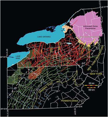
Figure 1.
Folds and faults in the Appalachian Basin of New York and Pennsylvania. Red lines in New York State = faults from Jacobi (2002). Yellow lines in New York State = faults from Rickard (1973). Green lines in New York State = anticline axes of folds above the Silurian evaporite section from Wedel (1932). Green lines in Pennsylvania = axes of folds above the Silurian evaporite section from Beardsley et al. (1999). White dashed polygon labeled “3D” in Pennsylvania indicates the general location of Figures 4–6, 8. White dashed box labeled “3D” in New York State indicates the general location of Figures 9–15. Green box in New York State indicates approximate location of Figure 2. Red area in northern Pennsylvanian labeled “K” indicates the center of the Kane gravity high (from Lash and Engelder, 2011; after Parrish and Lavin, 1982). Area outlined by yellow dashes labeled “OA” in northern Pennsylvania shows where the Middle Devonian Oriskany Sandstone is absent (from Kostelnik and Carter, 2009). Green region in western Pennsylvania and New York labeled “USA” signifies where the Middle Devonian Union Springs Member of the Marcellus Formation is absent (from Lash and Engelder, 2011). Labeled, blue, dashed lines indicate the center of selected northwest-striking cross-strike discontinuities. “B” indicates Bradford County. B-B = Blairsville–Broadtop Lineament; H-G = Home–Gallitzen Lineament; L-A = Lawrenceville–Attica Lineament; P-W = Pittsburgh–Washington Lineament; T-M = Tyrone–Mt. Union Lineament; U = unnamed lineament; W = Washington County Lineament (from Harper, 1989).
Figure 1. Folds and faults in the Appalachian Basin of New York and Pennsylvania. Red lines in New York State = faults from Jacobi (2002). Yellow lines in New York State = faults from Rickard (1973). Green lines in New York State = anticline axes of folds above the Silurian evaporite section from Wedel (1932). Green lines in Pennsylvania = axes of folds above the Silurian evaporite section from Beardsley et al. (1999). White dashed polygon labeled “3D” in Pennsylvania indicates the general location of Figures 4–6, 8. White dashed box labeled “3D” in New York State indicates the general location of Figures 9–15. Green box in New York State indicates approximate location of Figure 2. Red area in northern Pennsylvanian labeled “K” indicates the center of the Kane gravity high (from Lash and Engelder, 2011; after Parrish and Lavin, 1982). Area outlined by yellow dashes labeled “OA” in northern Pennsylvania shows where the Middle Devonian Oriskany Sandstone is absent (from Kostelnik and Carter, 2009). Green region in western Pennsylvania and New York labeled “USA” signifies where the Middle Devonian Union Springs Member of the Marcellus Formation is absent (from Lash and Engelder, 2011). Labeled, blue, dashed lines indicate the center of selected northwest-striking cross-strike discontinuities. “B” indicates Bradford County. B-B = Blairsville–Broadtop Lineament; H-G = Home–Gallitzen Lineament; L-A = Lawrenceville–Attica Lineament; P-W = Pittsburgh–Washington Lineament; T-M = Tyrone–Mt. Union Lineament; U = unnamed lineament; W = Washington County Lineament (from Harper, 1989).