The AAPG/Datapages Combined Publications Database
AAPG Bulletin
Full Text
![]() Click to view page images in PDF format.
Click to view page images in PDF format.
AAPG Bulletin, V.
DOI: 10.1306/04232120046
Relay ramps and rhombochasms in the northern Appalachian Basin: Extensional and strike-slip tectonics in the Marcellus Formation and Utica Group
Robert Jacobi,1 Joel Starr,2 Craig Eckert,3 Charles Mitchell,4 and Alan Leaver5
1Department of Geology, University at Buffalo, Buffalo, New York; [email protected]
2Peola Energy Resources, Pittsburgh, Pennsylvania; [email protected]
3Geologic Consultant, Bradfordwoods, Pennsylvania; [email protected]
4Department of Geology, University at Buffalo, Buffalo, New York; [email protected]
5Retired, Mars, Pennsylvania; [email protected]
ABSTRACT
Newly identified relay ramps and rhombochasms in the northern Appalachian Basin (NAB) require significant revision to the structural style, structural timing, and hydrocarbon ![]() migration
migration![]() components of the basin evolution model for the NAB. Relay ramps demonstrate that Neoacadian (Devonian) extensional tectonics affected the Devonian Marcellus Formation, earlier than the accepted Alleghanian (Carboniferous–Permian) tectonics. Relay ramps also confirm Ordovician Taconic extension affected the Ordovician Utica Group. Rhombochasms and possible Riedel shears in the Utica Group suggest a component of orogen-parallel, strike-slip motion during the Taconic Orogeny.
components of the basin evolution model for the NAB. Relay ramps demonstrate that Neoacadian (Devonian) extensional tectonics affected the Devonian Marcellus Formation, earlier than the accepted Alleghanian (Carboniferous–Permian) tectonics. Relay ramps also confirm Ordovician Taconic extension affected the Ordovician Utica Group. Rhombochasms and possible Riedel shears in the Utica Group suggest a component of orogen-parallel, strike-slip motion during the Taconic Orogeny.
In western Pennsylvania, a three-dimensional (3-D) seismic survey reveals that relay ramps terminate straight segments of faults and kink bands along the southeast borders of asymmetric, Salina Group “salt” pillows. The relay ramps are consistent with a local extensional environment associated with evaporite and mud or mudstone withdrawal and transport. Devonian sediments infill the grabens linked with the salt pillows, indicating that the grabens and associated faults initiated during the Devonian Neoacadian orogeny. Since the faults predate hydrocarbon generation, they were potentially ![]() migration
migration![]() pathways for hydrocarbons.
pathways for hydrocarbons.
In New York State, Ordovician (Taconic) rhombochasms in the NAB are inferred from (1) grabens observed in 3-D seismic surveys that occur at right stepovers of northeast-striking faults south of the New York promontory on the Taconic Laurentian margin and (2) grabens mapped at the surface that occur at left stepovers of north-northeast–striking faults north of the New York promontory. The opposite sense of inferred motion north and south of the promontory is compatible with Taconic escape tectonics away from the New York promontory.
INTRODUCTION
In the northern Appalachian Basin, anticlines (Figure 1) that lie structurally above the decollement in the Silurian Salina Group, as well as salt-collapse synclines, are generally believed to have developed during the Carboniferous to Permian Alleghanian orogeny (e.g., Frey, 1973; Harrison et al., 2004; Sak et al., 2012; Molofsky et al., 2013; Mount, 2014; Gillespie et al., 2015). The anticlines are generally thought to have been generated in response to foreland-directed slip on the decollement in a compressive stress regime (e.g., Mount, 2014). This stress regime resulted from the collision of Laurentia with Gondwana (e.g., Hatcher, 2005).
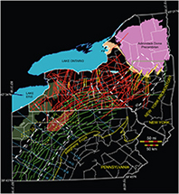 Figure 1. Folds and faults in the Appalachian Basin of New York and Pennsylvania. Red lines in New York State = faults from Jacobi (2002). Yellow lines in New York State = faults from Rickard (1973). Green lines in New York State = anticline axes of folds above the Silurian evaporite section from Wedel (1932). Green lines in Pennsylvania = axes of folds above the Silurian evaporite section from Beardsley et al. (1999). White dashed polygon labeled “3D” in Pennsylvania indicates the general location of Figures 4–6, 8. White dashed box labeled “3D” in New York State indicates the general location of Figures 9–15. Green box in New York State indicates approximate location of Figure 2. Red area in northern Pennsylvanian labeled “K” indicates the center of the Kane gravity high (from Lash and Engelder, 2011; after Parrish and Lavin, 1982). Area outlined by yellow dashes labeled “OA” in northern Pennsylvania shows where the Middle Devonian Oriskany Sandstone is absent (from Kostelnik and Carter, 2009). Green region in western Pennsylvania and New York labeled “USA” signifies where the Middle Devonian Union Springs Member of the Marcellus Formation is absent (from Lash and Engelder, 2011). Labeled, blue, dashed lines indicate the center of selected northwest-striking cross-strike discontinuities. “B” indicates Bradford County. B-B = Blairsville–Broadtop Lineament; H-G = Home–Gallitzen Lineament; L-A = Lawrenceville–Attica Lineament; P-W = Pittsburgh–Washington Lineament; T-M = Tyrone–Mt. Union Lineament; U = unnamed lineament; W = Washington County Lineament (from Harper, 1989).
In this paper, we present three-dimensional (3-D) seismic data from western Pennsylvania that suggest extensional structures in the Appalachian Basin developed earlier, during the Devonian Neoacadian orogeny. These newly identified structures, which affected the Marcellus Formation, include relay ramps at the termination of border faults along the southeastern margins of the anticlines. Our conclusion that Neoacadian extensional tectonics affected the Marcellus Formation in the northern Appalachian Basin is an outgrowth of our research conducted between 2012 and 2015 (Jacobi et al., 2012, 2013, 2015) and is consistent with the recent Gao et al. (2020) suggestion that Devonian deformation occurred in central Pennsylvania.
We interpret outcrop data in New York State (Figure 2) to suggest that relay ramps also occur in the Ordovician Trenton Group. An extensional stress regime inferred from these relay ramps is consistent with proposed normal fault motion that affected the Trenton Group and overlying Utica Group during the Ordovician Taconic Orogeny (e.g., Cushing and Ruedemann, 1914; Fisher, 1980; Bradley and Kidd, 1991; Jacobi and Mitchell, 2002). However, newly interpreted 3-D seismic and outcrop data in New York State also suggest that rhombochasms (releasing bends) involve the Trenton and Utica Groups. These features indicate that a component of orogen-parallel, strike-slip Taconic motion also affected the Trenton and Utica Groups. Such motion has not been previously proposed for the Taconic convergent faults in the Mohawk Valley of New York State.
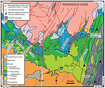 Figure 2. Geology map of the Mohawk Valley region, New York State, that displays the Mohawk Valley faults and associated faults. These faults sustained significant motion during the Taconic Orogeny. (Approximate location of Figure 2 shown as the green box in Figure 1). Geology generally from US Geological Survey website (US Geological Survey, 2016) and from Fisher (1980). Taconic mélange, Taconic allochthon, and Taconic intense deformation bands from Kidd (in Jacobi et al., 2016). Faults modified from Cushing and Ruedemann (1914), Fisher (1980), Bradley and Kidd (1991), Kidd et al. (1995), Hayman and Kidd (2002a, b), Cross et al. (2004), Agle et al. (2005, 2006a), and Jacobi et al. (2005), and generally follow those in O’Hara et al. (2017). Possible faults (indicated by black dashed outline of semitransparent fill) are modified from Jacobi (2002) and are based primarily on lineaments, several of which are coincident with known faults to the north. Red and yellow star indicates approximate location of core discussed in text. Large numbers in italics (1–5) indicate locations of grabens discussed in text. Black solid circle on Hoffmans Fault indicates location of kinematic indicators displayed in Figure 15. Labeled, white dashed boxes indicate locations of Figures 10 and 11A. Figure modified from Jacobi and Ebel (2019). Fault name abbreviations: Do = Dolgeville; E-G = East Galway; Eph = Ephrata; E-S-A = East Stone Arabia; Fo = Fonda; G-L = Galway Lake; Ho = Hoffmans; Hrk = Herkimer; L-F = Little Falls; Man = Manheim; M-C = Mother Creek; No = Noses; S-M = Saratoga-McGregor; Sp = Sprakers; T-H = Tribes Hill; W-G = West Galway; System name abbreviations: C = Cambrian; C-O = Cambrian–Ordovician; O = Ordovician; Q = Qal (Quaternary alluvium).
After an introduction to relay ramps and rhombochasms (releasing bends), this paper focuses on the following elements: (1) 3-D seismic data from western Pennsylvania that display relay ramps in the Devonian Onondaga Limestone, which underlies the Marcellus Formation (see Figure 3 for stratigraphic column); (2) application of the relay-ramp concept to possible analogues in the Cambrian–Ordovician outcrop belt in the Mohawk Valley of New York State; (3) 3-D seismic data that may indicate rhombochasms and Riedel shears in the Ordovician Trenton and Utica Groups in New York State; and (4) possible rhombochasm analogues in the Proterozoic to Utica outcrop belt in the Mohawk Valley region, New York State.
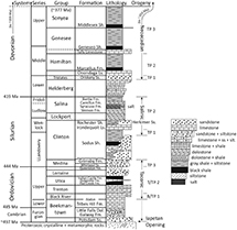 Figure 3. Generalized stratigraphic column for the northern Appalachian Basin stratigraphic section discussed in the text. Tectophase (TP), Blountian tectophase (B/TP), and Taconic tectophase (T/TP) from Ettensohn (1985, 2004, 2005, 2008) and Ettensohn and Brett (2002). Dashed arrow in the orogeny column indicates early tectonic events (back to ca. 505 Ma) that can be regarded as Taconic, even though they occurred offshore from the Laurentian margin (e.g., Macdonald et al., 2014, 2017). The Alleghanian orogeny occurred during Carboniferous–Permian times (off the figure). Radiometric age dates for the stratigraphic periods are from Walker et al. (2018). Note that “∼497” refers to the base of the upper Cambrian Potsdam Sandstone (Ss.) (the Cambrian Period extends back to ca. 541 Ma). Also note that Iapetan opening occurred circa 620–550 Ma (e.g., O’Brien and van der Pluijm, 2012; van Staal et al., 2013), during the time represented by the unconformity below the Potsdam Ss. Radiometric age date for the approximate end of Neoacadian is from Jacobi et al. (2018). The lithologic stratigraphic portions of the column are primarily after Smith and Nyahay (2005) and Nyahay et al. (2007). Dol. = Dolostone; Fm. = Formation; Ls. = Limestone; Sh. = Shale; slt. = siltstone; ss = sandstone.
A final objective is to illuminate the following eight implications of these newly recognized structural features. (1) Initial deformation in the section above the Silurian Salina Group in western Pennsylvania was related to the Devonian Neoacadian orogeny, not the Carboniferous–Permian Alleghanian orogeny. (2) Since the Neoacadian faults predate oil and gas generation, these faults were likely ![]() migration
migration![]() pathways for hydrocarbon away from the source beds. (3) Many of these faults above the Salina Group are in approximate alignment with faults below the Salina Group that extend down to Proterozoic rocks; these deeper faults are generally reactivated Neoproterozoic–Cambrian Iapetan-opening faults. The spatial relationship between faults below and above the Salina Group suggests that fault-block motion below the Salina evaporite influenced the deformation above the Salina Group and in some cases led to slumping with minimal downslope translation (since the faults above and below the evaporite remain approximately aligned). (4) Rhombochasms in the Ordovician Trenton and Utica Groups in New York State indicate a component of orogen-parallel strike-slip motion during the Ordovician Taconic Orogeny. (5) The high fracture porosity commonly associated with rhombochasms and Riedel shears make such features in the Ordovician Trenton and Utica Groups exploration targets. (6) The faults in New York State can have significantly different motion histories, even within the same fault system. Such varying fault motion histories result from differing reactivation responses to at least seven different tectonic episodes from Neoproterozoic Iapetan opening through the Ordovician Taconic Orogeny to Cretaceous uplift. (7) Such contrasting motion histories can result in significantly different fluid
pathways for hydrocarbon away from the source beds. (3) Many of these faults above the Salina Group are in approximate alignment with faults below the Salina Group that extend down to Proterozoic rocks; these deeper faults are generally reactivated Neoproterozoic–Cambrian Iapetan-opening faults. The spatial relationship between faults below and above the Salina Group suggests that fault-block motion below the Salina evaporite influenced the deformation above the Salina Group and in some cases led to slumping with minimal downslope translation (since the faults above and below the evaporite remain approximately aligned). (4) Rhombochasms in the Ordovician Trenton and Utica Groups in New York State indicate a component of orogen-parallel strike-slip motion during the Ordovician Taconic Orogeny. (5) The high fracture porosity commonly associated with rhombochasms and Riedel shears make such features in the Ordovician Trenton and Utica Groups exploration targets. (6) The faults in New York State can have significantly different motion histories, even within the same fault system. Such varying fault motion histories result from differing reactivation responses to at least seven different tectonic episodes from Neoproterozoic Iapetan opening through the Ordovician Taconic Orogeny to Cretaceous uplift. (7) Such contrasting motion histories can result in significantly different fluid ![]() migration
migration![]() histories, which in turn can result in strong compartmentalization. (8) Divergent Taconic strike-slip patterns on opposite sides of the New York promontory may reflect escape tectonics away from the buttress of the promontory.
histories, which in turn can result in strong compartmentalization. (8) Divergent Taconic strike-slip patterns on opposite sides of the New York promontory may reflect escape tectonics away from the buttress of the promontory.
Relay Ramps and Rhombochasms
Fault stepovers link individual fault segments in all the major groups of faults (normal, strike slip, and reverse). In extensional regimes, normal-fault segments can be linked by relay ramps, which have been recognized around the world (see reviews by Faulds and Varga, 1998, and Fossen and Rotevatn, 2016), including, for example, in the United Kingdom (e.g., Peacock and Sanderson, 1994); Canyonlands, United States (e.g., Trudgill and Cartwright, 1994; Commins et al., 2005; Pless, 2014); Basin and Range province in Oregon, United States (Crider, 2001); Mexico (Xu et al., 2011); Spain (Soliva et al., 2006); Italy (Di Bucci et al., 2006; Soliva et al., 2008); western Turkey (Gürboğa, 2014); the North Sea (e.g., Dawers and Underhill, 2000; McLeod et al., 2000); Greenland (Peacock et al., 2000); onshore Africa (e.g., Morley, 2002); and offshore Africa (e.g., Dutton and Trudgill, 2009). Linked normal-fault segments have also been modeled extensively (e.g., Acocella et al., 2005; Hus et al., 2005; Soliva et al., 2006, 2008; Whipp et al., 2016). However, to our knowledge, no relay ramps have been reported or modeled for the Northern Appalachian Basin, for either the Ordovician Trenton and Utica Groups or the Devonian Onondaga Limestone and Marcellus Shale. The lack of reported examples is largely because of a lack of continuous outcrop and, until recently, a lack of 3-D seismic surveys.
Rhombochasms (or releasing bends) develop at fault stepovers in strike-slip regimes. Rhombochasms have been recognized in orogenic belts around the world (e.g., Mann et al., 1983; see Mann, 2006, for a worldwide review). Additionally, rhombochasms have been modeled extensively (e.g., Choi et al., 2011; Mitra and Paul, 2011). However, no rhombochasms have been reported previously in the northern Appalachian Basin.
We report in this paper the first identification of both relay ramps and rhombochasms in the northern Appalachian Basin. These newly recognized structures have implications for deciphering the tectonic development of the basin. The relay ramps that occur above the Silurian evaporites of the Salina Group suggest that the deformation associated with these relay ramps developed initially in an extensional environment, not in a compressional environment as commonly envisioned (e.g., Sak et al., 2012; Mount, 2014; Gillespie et al., 2015). Furthermore, the proposed Late Devonian age of the relay ramps suggests that these fault systems were active during the Neoacadian orogeny, at least 50 m.y. before the commonly accepted age of structural development related to the Alleghanian orogeny (e.g., Frey, 1973; Harrison et al., 2004; Sak et al., 2012; Molofsky et al., 2013; Mount, 2014; Gillespie et al., 2015). Our proposed older age of fault initiation signifies that the faults would have been already in existence when oil generation occurred in the northern Appalachian Basin (Jacobi et al., 2012, 2013, 2015, 2018). The faults thus would have been potential conduits for oil and gas ![]() migration
migration![]() out of the Devonian black shales up into the higher Devonian sandstones like the Elk and Bradford (Jacobi et al., 2012, 2013).
out of the Devonian black shales up into the higher Devonian sandstones like the Elk and Bradford (Jacobi et al., 2012, 2013).
The proposed Ordovician rhombochasms indicate local transtensional deformation with a component of strike-slip, orogen-parallel motion in the foreland during the Ordovician Taconic Orogeny. Knowledge of the stress distributions that resulted in the transtensional deformation can not only help inform interpretations of the foreland basin tectonic history but also promote predictions of such details as the timing and orientation of fracture systems in the basin.
The importance of information concerning fracture network characteristics, including orientation, timing of development, and fracture aperture and sealing, has been recognized for decades in oil and gas exploration and in other fluid ![]() migration
migration![]() studies, such as contaminant
studies, such as contaminant ![]() migration
migration![]() and geothermal projects (e.g., Christie-Blick and Biddle, 1985; Zoback, 2010; Vignaroli et al., 2013). Recognition of rhombochasms can lead to highly productive fracture plays, since the local transtensional environment that characterizes a rhombochasm results in localized areas of relatively high fracture porosity (e.g., Christie-Blick and Biddle, 1985; Cunningham and Mann, 2007; Zoback, 2010; Mitra and Paul, 2011). The stepover faults and associated fracture networks will be at unexpectedly high angles to the general trends of the orogen-parallel fault systems (e.g., Mitra and Paul, 2011). Localized fracture plays related to Taconic rhombochasms most likely occur in other parts of Appalachian Basin where a component of Taconic strike-slip motion occurred.
and geothermal projects (e.g., Christie-Blick and Biddle, 1985; Zoback, 2010; Vignaroli et al., 2013). Recognition of rhombochasms can lead to highly productive fracture plays, since the local transtensional environment that characterizes a rhombochasm results in localized areas of relatively high fracture porosity (e.g., Christie-Blick and Biddle, 1985; Cunningham and Mann, 2007; Zoback, 2010; Mitra and Paul, 2011). The stepover faults and associated fracture networks will be at unexpectedly high angles to the general trends of the orogen-parallel fault systems (e.g., Mitra and Paul, 2011). Localized fracture plays related to Taconic rhombochasms most likely occur in other parts of Appalachian Basin where a component of Taconic strike-slip motion occurred.
Mohawk Valley Faults, Eastern New York State
The Mohawk Valley in eastern New York State has been a natural laboratory for more than 100 yr for those studying the Cambrian–Ordovician and its tectonic framework in the basin (e.g., Cushing and Ruedemann, 1914). Moreover, the region was the incubator, along with Newfoundland, for the seminal land-based plate tectonic models (Bird and Dewey, 1970). The Mohawk Valley continues to be an important area for contributions to evolving Taconic plate models (e.g., Macdonald et al., 2017; Jacobi and Mitchell, 2018). This importance reflects the fact that the Mohawk Valley is one of the few places along the eastern flank of the Appalachian Basin where the Cambrian–Ordovician sedimentary section and Taconic faults are exposed at the surface and where the relationships between stratigraphy and Taconic faulting can be examined in outcrop. Both the large-scale and small-scale elements and their geometries can be studied and linked when building a model for subsurface exploration in the eastern half of the Appalachian Basin. For that reason, we discuss the Ordovician structure of the Mohawk Valley in some detail and present new interpretations of that geology. The geology interpretations and models presented in this paper will promote a better understanding of what structures and structural effects might be expected for those who are working in the Ordovician Trenton–Black River and Utica targets of the Appalachian Basin.
The dominant faults in the Mohawk Valley strike north to northeast (Figure 2) and have been regarded as Ordovician Taconic normal faults based on field stratigraphic relationships (see reviews by Bradley and Kidd, 1991; Jacobi and Mitchell, 2018; Jacobi and Ebel, 2019). In the 1980s, eastward subduction-zone models suggested that the normal faults were related to plate flexure and plate subsidence as the Laurentian plate entered the subduction zone during the Taconic Orogeny (e.g., Jacobi, 1981; Rowley and Kidd, 1981; Stanley and Ratcliffe, 1985; Bradley and Kidd, 1991). More-recent models proposed that the faults are related to Taconic retro-arc foreland basin subsidence (e.g., Macdonald et al., 2014, 2017; Jacobi and Mitchell, 2018), although limited eastward subduction during final continent-arc collision also may have taken place.
The age of the Mohawk Valley faults was thought to be Ordovician (Taconic), based on several considerations. (1) The faults were assumed to die out upsection (to the south) in the Ordovician Utica Group and overlying Schenectady Formation of the Lorraine Group (e.g., Fisher, 1980). (2) The faults were believed to not offset the Silurian unconformity (e.g., Bradley and Kidd, 1991). (3) Conglomerates in the Ordovician Black River and Trenton Groups are localized adjacent to the faults (Bradley and Kidd, 1991). (4) On the horst west of Noses Fault, the missing Trenton Group suggested uplift between Beekmantown and Utica time of deposition (e.g., Ruedemann, 1912; Fisher, 1980; Bradley and Kidd, 1991). (5) Ordovician slump folds in the Trenton and Utica were thought to reflect tectonic instability (Kay, 1937; Fisher, 1979; Bradley and Kidd, 1991; Jacobi and Mitchell, 2002; Jacobi et al., 2002). (6) Ordovician growth fault geometries were inferred from large-scale map patterns (Bradley and Kidd, 1991) and from cross sections utilizing outcrop biochronology and tephrochronology (Jacobi and Mitchell, 2002, 2018).
The first consideration above is unconvincing because poor outcrop and imprecise stratigraphy did not promote fault recognition where the faults were thought to die out. The second consideration is also tenuous since regional mapping, especially in covered areas, could not recognize small offsets of the Ordovician–Silurian contact. The following four considerations do not preclude fault motion prior to, or subsequent to, Ordovician Taconic movement. In fact, the motion history of the Mohawk Valley faults is considerably more complex than originally presumed, based on both recent field research and interpretations of two-dimensional (2-D) and 3-D seismic reflection data, (e.g., Bosworth and Putman, 1986; Jacobi, 2002, 2011, 2012; Valentino et al., 2012).
Many of the faults initiated during Neoproterozoic–Cambrian Iapetan-opening times. Some were reactivated at the time of the Cambrian–Ordovician boundary. All were reactivated during the Ordovician Taconic Orogeny, and some were reactivated during the Silurian Salinic, Devonian Neoacadian, and Carboniferous–Permian Alleghanian orogenies, as well as during Cretaceous uplift and more-recent times (for detailed reviews, see Jacobi, 2010; Jacobi and Mitchell, 2018; Jacobi and Ebel, 2019).
Interpretations of 3-D seismic surveys presented in this paper confirm that significant Paleozoic motion on most of the faults indeed ended during the Taconic Orogeny (for location of seismic surveys southwest of the Mohawk Valley, see Figure 1). Interpretations of the same 3-D seismic surveys also suggest, however, that faults with similar orientations, and in some cases, within the same fault system, have different timings of cessation and sense of slip (Jacobi, 2011, 2012). Some of these reactivated faults offset the entire Cambrian–Devonian sedimentary section, signaling Alleghanian and possibly more-recent motion.
In this paper, we present a relay-ramp interpretation for Cushing and Ruedemann’s (1914) mapping along the Saratoga-McGregor Fault and for fault blocks to the northwest (e.g., Kidd et al., 1995). This interpretation supports the more than 100-yr traditional view that the Mohawk Valley faults are normal faults. However, results from recent field work (Schweigel et al., 2015, 2017) and from recent 3-D seismic surveys (Jacobi, 2012) presented in this paper suggest that some of the Mohawk Valley faults also sustained a component of strike-slip motion. An implication of the strike-slip component is that in a strike-slip regime, rhombochasms can form at fault stepovers, given the appropriate sense of motion and sense of stepover (e.g., Christie-Blick and Biddle, 1985). Rhombochasms can lead to anomalously thick sedimentary sections and anomalously high fracture porosity that would affect oil and gas production and contaminant transport (e.g., Zoback, 2010).
Differing fault timings and differing senses of motion on the Mohawk Valley faults suggest that apparent fault motion histories based on a few data points should not be extrapolated with a high degree of confidence to entire networks of faults in the northern Appalachian Basin. Such generalizations can lead to incorrect assumptions concerning the fault motion history of individual faults and consequent faulting factors such as timing of hydrocarbon and hydrothermal ![]() migration
migration![]() along faults (Jacobi, 2012). The different timings of fault motion can lead to significant local compartmentalization.
along faults (Jacobi, 2012). The different timings of fault motion can lead to significant local compartmentalization.
RELAY RAMPS ON THE DEVONIAN ONONDAGA LIMESTONE IN A 3-D SEISMIC SURVEY, PENNSYLVANIA
The 3-D seismic survey discussed in this paper is located in western Pennsylvania (Figure 1). Asymmetric anticlines with faulted southeast limbs are prominent features in the time-structure map and isometric view of the Devonian Onondaga Limestone (Figure 4) and are typical of the region. The anticline cores consist of Silurian evaporite, mudstone, and siltstone (Jacobi et al., 2013, 2015). Yoked, generally narrow synclines and grabens occur southeast of the anticlines. The folds and associated faults are commonly ascribed to Alleghanian (Carboniferous–Permian) deformation related to foreland-directed slip above the Silurian evaporite section (e.g., Sak et al., 2012; Molofsky et al., 2013; Mount, 2014). However, Jacobi et al. (2013, 2015) proposed that these structures initiated during the Devonian Neoacadian orogeny. In this model, the structures initiated in response to limited gliding and slumping of Silurian Salina units (and overlying units) down a paleoslope that was directed southeasterly toward the hinterland. The locations of the slump (scarp) faults commonly are approximately aligned with faults that affect the section below the Salina Group. These deeper faults demarcate fault blocks with different dips and subsea elevations of the Silurian Lockport and deeper reflectors. The deeper faults extend down to Iapetan-opening-Rome trough faults that display growth faults geometries. The slumping in the Silurian–Devonian section was apparently related to reactivations of these Iapetan structures. Alleghanian reverse faults and kink bands that affect the Devonian and Carboniferous section also are aligned with the structurally deeper faults. This alignment suggests that the later Alleghanian deformation also was guided by the deeper structures (e.g., Jacobi, 2002; Scanlin and Engelder, 2003; Jacobi et al., 2013, 2015).
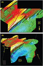 Figure 4. (A) Time-structure map on the Devonian Onondaga Limestone in a three-dimensional (3-D) seismic survey. The seismic survey is located within the white dashed polygon in Pennsylvania in Figure 1. Northeast-striking black lines indicate major faults at the Onondaga Limestone level. Anticline axis (red line) that is mapped in the near-surface and surface Carboniferous coal measures (more than 1 mi [>1.6 km] above the Onondaga surface) swings from one Onondaga anticline to the next. Contour interval is 8 ms (∼17 m [∼56 ft]). The color ramp is from white and yellow = high to blue = low. The small white blocks in the image are areas of no data (“cut-outs”). (B) Isometric view of the Onondaga Limestone surface shown in (A), looking north. Significant relay ramps are numbered 1–5. The number 4 refers to the relay ramp partially hidden in this isometric view. The 3-D seismic survey is located within the white dashed polygon in Pennsylvania in Figure 1. Horizontal scale is correct at the front of the isometric view. The vertical “up” arrow is approximately 175 m (∼575 ft) in the approximate center of the isometric view. This surface is in the depth domain. The depth domain was calculated by using well ties between formation tops and interpreted horizons to build a
 ![]() velocity
velocity![]() model that allowed us to convert the time domain (in (A)) to depth (B).
model that allowed us to convert the time domain (in (A)) to depth (B).
The northeast-striking faults that border the anticlines are distinctly straight segments at the Onondaga stratigraphic level (Figure 4). In contrast, the axes of near-surface to surface anticlines, more than a mile (>1600 m) above the Onondaga structures, swing from one Onondaga anticlinal crest to another (see red line marking a mapped surface fold axis in Figure 4A). These shallow anticline axes were mapped from the disposition of near-surface Carboniferous coal measures and from surface units (e.g., Socolow, 1980; Beardsley et al., 1999; Faill and Nickelsen, 1999). The sharp bends in the mapped surface-anticline axes thus mark fault stepovers in the deeper section. The bends also suggest that local cross-strike discontinuities (CSDs) inferred from surface fold disruptions are controlled by the deeper stepovers and relay ramps.
The northeast-striking fault segments are soft linked by distinct unbreached relay ramps at various scales (the larger relay ramps are numbered in Figure 4B). In the 3-D seismic survey, most of the fault systems that offset the Onondaga reflector appear to be normal faults (Figure 5), as might be expected from the proposed presence of relay ramps. The faults that extend upsection from the Tully reflector, however, are thrust faults (Figure 5). Similar thrusts have been recognized farther north in the basin by Mount (2014), although Mount (2014) suggested that the thrusts extend unbroken down into the Salina Group.
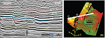 Figure 5. (A) Dip section in the three-dimensional (3-D) seismic survey across faults in the westernmost part of the 3-D seismic survey (for location see (B)). The three labeled faults (A–C) appear to be normal faults, and the throw on fault B is approximately 40 ms. (∼85 m [∼280 ft]). The normal fault locations are denoted in (B). The number 5 indicates relay ramp 5 in Figure 4B. A selected thrust fault is marked by the red dashed line; this fault has an apparent dip of approximately 16° and a true dip of approximately 28°. The thrust offsets the Tully and Sonyea reflectors. Seismic data used in this interpretation are courtesy of and owned by Seitel. (B) Locations of the three faults (A–C) and the seismic section that are displayed in (A) are shown on an isometric view of the northwestern part of the Onondaga surface that is displayed in Figure 4B. Fault A is the southeastern boundary fault of relay ramp 5 in Figure 4B and (A) and (B).
The amount of throw on the Onondaga reflector varies along the strike of the faults. At the cross-section location (Figure 5), fault B has a throw of approximately 40 ms (∼85 m [∼280 ft]), but the throw increases to the southwest. Maximum fault throw on the Onondaga reflector along the central fault southwest of relay ramp no. 3 is approximately 427 m (∼1400 ft) and declines near relay ramp no. 3 (Figure 4B). The displacement profile along central faults (Figure 6) linked by relay ramp no. 4 (Figure 4B) does not yield a ![]() constant
constant![]() cumulative throw across the linkage zone of the relay ramp no. 4 (Figure 6), which suggests that the faults are soft linked; that is, the fault segments are not splay linked at depth (e.g., Childs et al., 2003). The inferred soft link is consistent with the seismic section in Figure 5A where the individual faults (A, B, and C) are not connected at depth.
cumulative throw across the linkage zone of the relay ramp no. 4 (Figure 6), which suggests that the faults are soft linked; that is, the fault segments are not splay linked at depth (e.g., Childs et al., 2003). The inferred soft link is consistent with the seismic section in Figure 5A where the individual faults (A, B, and C) are not connected at depth.
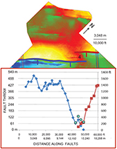 Figure 6. Profiles of fault throw. The upper panel shows the color-coded fault locations and relay ramp no. 4 on the time-structure map of the Devonian Onondaga Limestone; this map is the central and northwestern parts of Figure 4A. The color ramp is from white and yellow = high to blue = low. The lower panel displays the profiles of fault throw along the strike of the two color-coded faults linked by relay ramp no. 4. The azure blue circles indicate the cumulative throw of the red and blue faults in the region of the relay ramp.
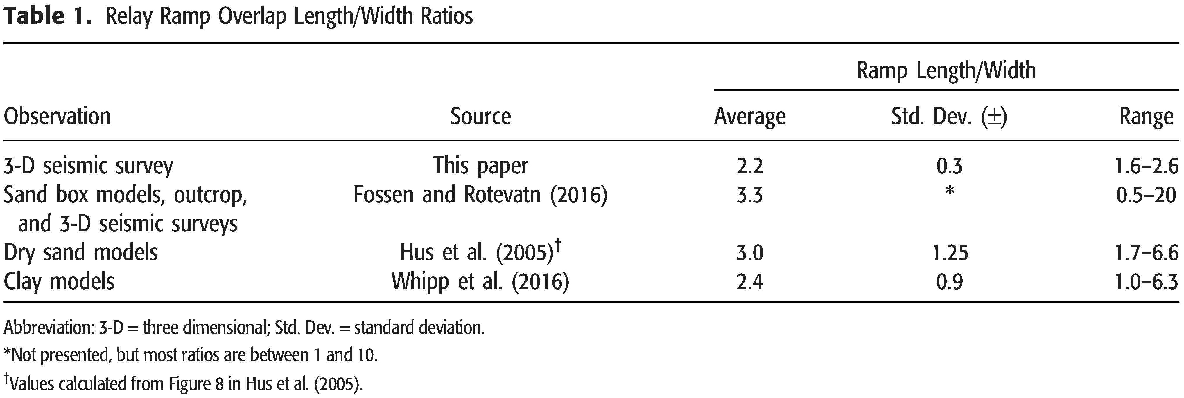
The overlap length/width ratio of relay ramps is dependent upon fault length, fault throw, physical properties, and mechanical thickness (e.g., Fossen and Rotevatn, 2016). The length/width ratios of relay ramps in models, outcrops, and 3-D seismic surveys are fairly ![]() constant
constant![]() over nine orders of magnitude of fault overlap lengths (Table 1; Hus et al., 2005; Fossen and Rotevatn, 2016; Whipp et al., 2016). The overlap length/width ratios of the seven larger relay ramps in the 3-D seismic survey have an average of 2.2 with a standard deviation of 0.33 and a range from 1.7 to 2.9. These ratios are within the range found for dry sand models, clay models, and natural examples (see Table 1; Hus et al., 2005; Fossen and Rotevatn, 2016; Whipp et al., 2016).
over nine orders of magnitude of fault overlap lengths (Table 1; Hus et al., 2005; Fossen and Rotevatn, 2016; Whipp et al., 2016). The overlap length/width ratios of the seven larger relay ramps in the 3-D seismic survey have an average of 2.2 with a standard deviation of 0.33 and a range from 1.7 to 2.9. These ratios are within the range found for dry sand models, clay models, and natural examples (see Table 1; Hus et al., 2005; Fossen and Rotevatn, 2016; Whipp et al., 2016).
Ramp widths are commonly approximately half the mechanical thickness (Soliva et al., 2006; Fossen and Rotevatn, 2016). The average half width of the five labeled relay ramps in the 3-D seismic survey (Figure 4B) is 764 m (standard deviation = 122 m). Since the present thickness between the base of the relay ramp at the deformed Salina Group and the Tully Limestone is on the order of 300 m, it is probable that the mechanical layer included at least the Helderberg to Tully interval and may have included strata higher in the section. Thus, fracturing related to the relay ramp formation such as localized fracture intensification domains (e.g., O’Hara et al., 2017) along the faults and localized cross joints can be expected to affect both the Marcellus and Geneseo black shales.
The average dip of the seven larger relay ramps in the 3-D survey is approximately 3° (with a standard deviation of 1.5°), and the average maximum dip is approximately 5°, with a standard deviation of 1.5°. These low dips are consistent with the generally unbreached nature of the relay ramps, as observed in seismic slices through the 3-D survey. Elsewhere relay ramps appear to become breached (faulted) as the deformation increases to maximum dips on the order of 13°–18° (see Fossen and Rotevatn, 2016, for a review). Rotation of the relay ramp dip azimuth away from colinearity with the strike of the faults as the fault tips progressively interact is also common elsewhere (see Fossen and Rotevatn, 2016, for a review). Such rotation is observed only to a limited extent in the 3-D seismic survey (Figure 4). The limited rotation is also consistent with the unbreached nature of the relay ramps.
Longitudinal (strike) seismic sections along the length of the relay ramps in the 3-D seismic survey (Figure 4) show two end members for the relay ramp configuration (Figure 7). These end members reveal clues concerning the ramp (and associated graben) development. In one end member, the aerial extent of the zone of removed material beneath the ramp increases upsection toward the upper end of the ramp in a stepwise manner across reflectors, resulting in a stepped-back profile (Figures 7; 8A, C), such as might be expected for an erosional profile or sediment slide scar. The (pseudo) decollement is above the successive steps and below the continuous reflectors at the base of the relay ramp. In the alternative ![]() case
case![]() (Figures 7; 8B, C), the relay ramp was formed by removal of successively more material (areally) downsection toward the upper end of the ramp, forming half of a turtle structure (see Hudec et al., 2011; Quirk et al., 2012, for examples of turtle structures). In this
(Figures 7; 8B, C), the relay ramp was formed by removal of successively more material (areally) downsection toward the upper end of the ramp, forming half of a turtle structure (see Hudec et al., 2011; Quirk et al., 2012, for examples of turtle structures). In this ![]() case
case![]() , the main decollement is immediately above the reflector along which the overlying reflectors of the relay ramp structurally “downlap.” Since this line of section is a strike line, the structures indicate longitudinal flow of material during removal as well as the expected orthogonal flow. Most of the larger relay ramps appear to be a combination of the two end members but with a dominance of the turtle structure.
, the main decollement is immediately above the reflector along which the overlying reflectors of the relay ramp structurally “downlap.” Since this line of section is a strike line, the structures indicate longitudinal flow of material during removal as well as the expected orthogonal flow. Most of the larger relay ramps appear to be a combination of the two end members but with a dominance of the turtle structure.
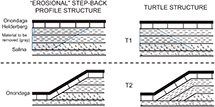 Figure 7. Cartoon models of a longitudinal slice through a relay ramp showing two developmental processes for the relay ramps in the Pennsylvania three-dimensional seismic survey. In the left panels that portray the step-back profile structure, successively more material is removed areally upsection, whereas in the right panels that portray the turtle structure, successively more material is removed areally downsection. T = time.
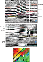 Figure 8. (A) Longitudinal (strike) seismic slice in the three-dimensional (3-D) seismic survey along the length of the relay ramp labeled no. 3 in Figure 4B. See (C) for the location of the line of section. In the relay ramp, the positive reflector directly below no. 1 truncates reflectors no. 2, 3, and 4; more material was removed upsection toward the upper (northeast) end of the ramp, as could be expected in normal erosion or slump scars. The detachment marking the zone of removal in this
 ![]() case
case![]() climbs up section at the relay ramp along the positive reflector below no. 1. The subdetachment reflector (labeled “sub-detach.”) is approximately at the Lockport Group reflector. Seismic data used in this interpretation are courtesy of and owned by Seitel. (B) Longitudinal (strike) seismic slice along the length of the relay ramp labeled no. 4 in Figure 4B. See (C) for the location of the line-of-seismic section. In the relay ramp, the positive reflectors no. 1 to 4 structurally downlap onto reflector no. 5 at the vertical arrows. More material (areally) was removed downsection toward the upper (southwest) end of the ramp, as in a turtle structure. The detachment marking the zone of removal at the relay ramp (reflector no. 5) parallels the subdetachment reflector (labeled “sub-detach.”). Truncated reflectors in the upper right represent complex geometry of out-of-plane layers and faults that dip orthogonally to the seismic section and that intersect the seismic section. Seismic data used in this interpretation are courtesy of and owned by Seitel. (C) Locations of the longitudinal sections (thick, dashed, black lines) in (A) and (B) (italicized letters on map refer to (A) and (B), respectively). Numbers 3 and 4 refer to relay ramps no. 3 and 4 in the 3-D seismic survey displayed in Figure 4B. Map base is the central part of Figure 4A. Color ramp is warm colors = highs, cool colors = lows. The small white blocks in the image are areas of no data (“cut-outs”).
climbs up section at the relay ramp along the positive reflector below no. 1. The subdetachment reflector (labeled “sub-detach.”) is approximately at the Lockport Group reflector. Seismic data used in this interpretation are courtesy of and owned by Seitel. (B) Longitudinal (strike) seismic slice along the length of the relay ramp labeled no. 4 in Figure 4B. See (C) for the location of the line-of-seismic section. In the relay ramp, the positive reflectors no. 1 to 4 structurally downlap onto reflector no. 5 at the vertical arrows. More material (areally) was removed downsection toward the upper (southwest) end of the ramp, as in a turtle structure. The detachment marking the zone of removal at the relay ramp (reflector no. 5) parallels the subdetachment reflector (labeled “sub-detach.”). Truncated reflectors in the upper right represent complex geometry of out-of-plane layers and faults that dip orthogonally to the seismic section and that intersect the seismic section. Seismic data used in this interpretation are courtesy of and owned by Seitel. (C) Locations of the longitudinal sections (thick, dashed, black lines) in (A) and (B) (italicized letters on map refer to (A) and (B), respectively). Numbers 3 and 4 refer to relay ramps no. 3 and 4 in the 3-D seismic survey displayed in Figure 4B. Map base is the central part of Figure 4A. Color ramp is warm colors = highs, cool colors = lows. The small white blocks in the image are areas of no data (“cut-outs”).
RELAY RAMPS IN THE ORDOVICIAN TRENTON–UTICA IN THE MOHAWK VALLEY, NEW YORK STATE
The Saratoga-McGregor Fault has generally been regarded as the easternmost Ordovician (Taconic) exposed normal fault with significant throw in the Mohawk Valley region (Figure 2; e.g., Bradley and Kidd, 1991). At Saratoga Springs, New York (Figure 2), Cushing and Ruedemann (1914) proposed a fault horse (not horst) between parallel faults of the Saratoga-McGregor Fault. Their illustrations of the horse are remarkably similar to a relay ramp (Figure 9). Although most of the outcrop they examined is now covered, we suggest that the horse is a relay ramp joining Saratoga-McGregor Fault segments.
 Figure 9. Saratoga-McGregor Fault zone at Saratoga Springs, New York (for location of Saratoga Springs, see Figure 2). We suggest this figure, modified with permission from figure 7 in Cushing and Ruedemann (1914), portrays a relay ramp. The Amsterdam Limestone is equivalent to the Trenton Group, and the Canajoharie Shale is equivalent to the Utica Group (see Figure 3 for stratigraphic relationships of Trenton and Utica Groups).
On a larger scale, between Hoffmans Fault and Ruedemann’s Line (Figure 10), the map pattern of fault offsets involving contacts of Ordovician clastics (units U, 1, and 2 south of Saratoga Springs on Figure 10) could be construed to indicate relay ramps wherein the primary motion on the normal fault steps right successively to the north. Such an offset pattern can also be observed at a subsidiary fault west of Saratoga-McGregor Fault at Saratoga Springs (Figure 2), where the carbonate–Utica contact is displaced. Other factors could contribute to the apparent relay ramp map pattern, each with an unknown degree of importance, however, such as (1) down-to-the-east normal faults that offset the regional southward dip off the Adirondack dome and (2) a limited amount of left-lateral motion on the normal faults. However, the Saratoga-McGregor Fault does not appear to have sustained strike-slip motion based on kinematic indicators in an unoriented core on a splay of the fault (star in Figures 2, 10; Hanson et al., 2010, 2011). We suggest map patterns similar to those at Saratoga Springs (Figure 10) that occur along the Montmorency and Chateau Richer fault systems in the St. Lawrence Lowlands (figure 3 in Shaw, 1993) may also have a relay-ramp origin as an important contributing factor, rather than left-lateral strike-slip motion that displaced originally contiguous units as suggested by Shaw (1993).
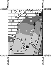 Figure 10. Generalized geological map of the Schenectady region, New York State. Location of map shown as white-dashed box labeled “Fig. 10” in Figure 2. Dashed bold lines indicate normal fault traces. Solid bold lines indicate Taconic thrusts. Star = approximate location of core discussed in text. Map from Kidd in Jacobi et al. (2016) and modified from Fisher (1980), Plesch (1994), and Kidd et al. (1995). 1 = Ordovician flysch (shale and silt facies of the Lorraine Group), which overlies the Utica Group; 2 = coarser Ordovician flysch of the Schenectady Formation (arenite facies of the Lorraine Group), which overlies unit no. 1; C-O = Cambrian–Ordovician carbonate bank; d2 = deformed Ordovician arenite facies of the Lorraine Group; Ho = Hoffmans Fault; m = Taconic melange; PC = Precambrian rocks; RL = Ruedemann’s Line (western extent of Taconic thrusting); Sch = Schenectady; S-M = Saratoga-McGregor Fault; S.S. = Saratoga Springs; U = Ordovician Utica Group.
The Little Falls Fault displays three fault stepovers (Figures 2, 11; e.g., Cushing, 1905; Agle et al., 2005; Jacobi et al., 2005), but relay ramps at the fault stepovers are not observed. Where outcrop exists, the stepovers are faults, with a narrow zone of steeply dipping bedding and breccia with Utica bedding on the downthrown side flattening out within approximately 230 m of the cross fault (Cushing, 1905, p. 42). Remapping the area (Agle et al., 2005; Jacobi et al., 2005), showed that the outcrops of Cushing (1905) are mostly covered, but the nearest outcrop to the fault with flat Utica bedding is approximately 230 m from the fault (Figure 11B). The overlap (ramp) length/width ratio is thus smaller than approximately 0.13. This ratio is an order of magnitude smaller than the relay ramp ratios from models (e.g., Hus et al., 2005) and those observed in the 3-D seismic survey in this paper. Essentially only very small relay ramps, if any, exist at these surface localities. Although relay ramps are not observed at the fault stepovers, the fault motion was dip slip at the time of slickenfiber generation since slickenfibers plunge downdip at the stepover (Figure 11B).
 Figure 11. (A) Simplified geologic map of the Little Falls quadrangle (location of (A) shown in Figure 2 as dashed white box labeled “Fig. 11A”). Heavy, solid black lines indicate known fault locations, tics on downthrown side; heavy black or white short-dashed lines indicate inferred fault locations. Thin black or white long-dashed lines indicate topographic lineaments. Black box labeled “Fig. 11B” indicates approximate location of (B). Figure after Agle et al. (2005, 2006a, b), Jacobi et al. (2005). (B) Geologic map of fault stepover area of Little Falls Fault. Location of map is shown by labeled box in (A). Figure after Agle et al. (2005), Jacobi et al. (2005). Red lines = fault traces; solid red lines = less than 15 m uncertainty; dashed = approximate; dotted = inferred; CLf = Cambrian Little Falls Dolostone; ODo = Ordovician Dolgeville Formation of the Utica Group; OIc = Ordovician Indian Castle Formation of the Utica Group; OTh = Ordovician Tribes Hill Formation; OTr = Ordovician Trenton Group; OU = Ordovician Utica Group; pC-OTr = Proterozoic rocks and overlying section of Cambrian Potsdam Sandstone through Ordovician Trenton Group (the Cambrian–Ordovician Great American carbonate bank of Landing, 2012); Q = Quaternary.
The lack of a significant relay ramp at the stepovers has three possible contributing factors. One factor is that the relay ramps here continued developing to stage 4 (late stage) of Peacock and Sanderson (1994), wherein a fault orthogonal to the main fault trend has taken up much of the strain. In this model, a relay ramp might exist below the ground surface in the underlying carbonates northeast of the northwest-striking stepover faults. This factor, with an unexposed relay ramp, is consistent with Cushing’s (1905) estimate that the exposed cross fault exhibits less than half the throw estimated on the northeast-striking segments (p. 41).
A second factor is that the Cambrian–Ordovician carbonate bank section was apparently already lithified at the time of major fault motion, yet the overlying shale of the Utica Group and coarser clastics were still ductile, resulting in horsts with flat-lying carbonates adjacent to the faults and narrow zones of steeply dipping, drag-folded clastic sections on the downthrown sides, as observed along the Little Falls, Dolgeville, and Manheim Faults (e.g., Bradley and Kidd, 1991; Jacobi et al., 2005).
A third factor may be that preexisting faults that developed during the Neoproterozoic–Cambrian Iapetan-opening events controlled the development of the northwest-striking stepover faults. Such northwest-striking faults with significant throw in the Proterozoic rocks can be inferred from gravity modeling (Benoit et al., 2014). The topographic lineaments (thin dashed black and white lines in Figure 11A) that extend beyond the presently mapped stepover faults probably represent small-scale offsets and fracture intensification domains along reactivated parts of longer northwest-striking fault systems that may have initiated during Iapetan opening.
RHOMBOCHASMS IN ORDOVICIAN TRENTON AND UTICA GROUPS INTERPRETED IN 3-D SEISMIC SURVEYS IN EASTERN NEW YORK STATE
Small 3-D seismic surveys southwest of the Mohawk Valley (Figure 1) shot for Norse Energy display a series of en-echelon fault systems that affect the section from the top of the Proterozoic basement to the Ordovician Trenton and Utica Groups (Figure 12A). The time-structure map on the top of the Proterozoic basement reflector exhibits a series of en-echelon grabens with the deepest regions near the stepovers at the northern part of each fault segment (Figure 12A, B). This relationship is especially clear at the graben labeled no. 2 in Figure 12A. The deepest parts of the grabens are also most extensive spatially near the stepover (graben no. 4 in Figure 12A). These observations (Figure 12) suggest that the deepest parts of the grabens developed as rhombochasms (or releasing bends, Figure 12C). The right-step fault geometry at the rhombochasms implies that right-lateral motion occurred along a generally northeast-southwest trend (Figure 12C). This motion probably occurred in a locally transtensional environment since the grabens extend along much of the length of the individual fault segments (Figure 12A).
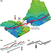 Figure 12. (A) Time-structure map on the top of Proterozoic basement in eastern New York State based on three-dimensional seismic surveys. Approximate location is within the eastern white-dashed box in Figure 1. Color ramp for depth is green and orange = high, blue = low. Red line indicates the generalized trace of the main series of linked northeast-striking faults. Dashed black line indicates approximate northwestern extent of significant downwarping related to the grabens. Both the black dashed line and the red line display right steps in the fault system. Brown hachured lines indicate fault traces picked on each inline and crossline (dip-slip component of fault motion is down on the hachured side). Easterly striking fault traces are indicated by red and white arrows (see text for discussion of red and white arrows). Yellow arrows indicate deepest parts of the grabens, which are located near right steps of the fault system. This geometrical relationship is especially evident in the southwestern two grabens (no. 1 and no. 2). (B) Simplified schematic diagram of (A) that displays the relationships among the fault segments, fault right steps, and deepest extents of the grabens (blue ellipses). The black dashed line indicates the approximate outline of the southeastern side of the grabens. The right steps of the main fault (in red) and associated deepest parts of the grabens are interpreted to represent rhombochasms that developed in a right-lateral locally transtensional regime. (C) Simplified schematic diagram showing the development of a rhombochasm at the right step of a right-lateral strike-slip fault.
Apparent normal faults with small throws swing away from the graben in the southeast corner of the 3-D survey (brown faults that are indicated by red and white arrows in Figure 12A). The swing in strike is consistent with an approximately east-west orientation of the maximum horizontal stress (SHmax) inferred from the rhombochasm model. The map pattern of the small-throw faults is similar to that of Riedel shears (such as the fault indicated by the white arrow in Figure 12A).The orientation of these possible Riedel shears implies right-lateral motion along the overall trend of the grabens, the same sense of motion that was deduced from the proposed rhombochasms. In contrast, these normal faults are not consistent with left-lateral motion along the graben trend that would have resulted from a north-northeast– to north-oriented SHmax.
Growth fault geometries across the grabens observed in the 3-D seismic surveys indicate that the graben development and fault motion occurred primarily during Trenton and Utica deposition. In the particular example displayed in Figure 13, much of the graben development occurred immediately after Trenton deposition, based on the thickened section immediately above the Trenton reflector in the graben. Some grabens also show a thickened Trenton reflector interval, suggesting activity during Trenton deposition, as well. Syndepositional normal faulting of the Trenton has also been proposed based on surface geological relationships (e.g., Selleck, 2014). The fault on the southeastern side of the graben in Figure 13 appears to have continued further motion during the Taconic Orogeny, since the fault offsets reflectors above the Trenton reflector, including the Lorraine reflector of the Taconic Queenston clastic wedge.
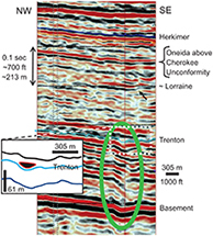 Figure 13. Seismic section across one of the grabens in the three-dimensional seismic surveys of Figure 12A (graben is indicated by the green ellipse in the seismic section). The graben is infilled primarily by the basal Utica Group, which overlies the Trenton Group. In the enlarged inset, the infill is indicated by the black blob. Note that the reflectors above the infill pass over the graben with little offset. The infill suggests a late Trenton Group to earliest Utica Group time of deposition for primary development of the rhombochasm. Arrow indicates probable offset of Lorraine reflector. The vertical scale is correct for units above the Trenton Group.
The faults associated with the graben apparently totally ceased motion by the end of Ordovician since the Cherokee unconformity, which approximates the base of the Silurian in the Mohawk Valley region (e.g., Swezey, 2002), appears generally undisturbed above the graben (Figure 13). The Cherokee unconformity marks the end of the Taconic tectophase of the Taconic Orogeny (Figure 3; e.g., Ettensohn and Brett, 2002; Ettensohn, 2004). In other 3-D surveys, the faults have different timings of final cessation, and a few penetrate the entire Devonian section (Jacobi, 2011, 2012). These variable times of fault cessation inferred from the seismic sections are consistent collectively with (1) the Late Ordovician faulting in the Mohawk Valley determined from the age of breccias and growth fault sections in the Upper Ordovician Black River, Trenton and Utica section (e.g., Bradley and Kidd, 1991; Jacobi and Mitchell, 2002); (2) the inferred reactivated faulting that affected the Silurian and Devonian units (Jacobi and Smith, 2000, for a review see Jacobi and Mitchell, 2018; Jacobi and Ebel, 2019); and (3) highly compartmentalized effects of (multiple) hydrothermal circulation events (e.g., Smith, 2006; Marner et al., 2008; Jacobi et al., 2018; Hunt, 2020).
RHOMBOCHASMS INFERRED FROM GEOLOGICAL MAP PATTERNS IN EASTERN NEW YORK STATE
In the southeastern part of the Adirondack dome, a series of small grabens that contain Cambrian–Ordovician sedimentary rocks are surrounded by Proterozoic units (grabens no. 1–3 in Figure 2). The only specifically studied graben is the “Wells outlier,” located at Wells, New York (graben no. 1 in Figure 2; Miller, 1916; Fisher, 1957). This graben involves probable Cambrian sandstone, sandy dolomite, and dolomite overlain successively by strata of the Ordovician Black River, Trenton and Utica Groups (e.g., Miller, 1916; Fisher, 1957). Shale of the Utica Group is drag folded against the western, north-northeast–striking boundary fault.
Since the Wells outlier graben occurs where the western boundary fault of the graben exhibits a jog (Figure 2; see map by Fisher, 1957), and since investigators have proposed that some of the north-northeast–striking faults mapped in the Adirondack dome sustained a component of strike-slip motion (e.g., Jacobi, 2012; Valentino et al., 2012; Jacobi et al., 2015), the Wells outlier graben is likely a rhombochasm at the stepover. Grabens no. 2 and no. 3 in Figure 2 also occur where north-northeast–striking faults exhibit left steps. All three grabens are thus probably rhombochasms that developed during left-lateral strike-slip motion parallel to the Appalachian orogen (Jacobi, 2012; Jacobi et al. 2015).
Based on aeromagnetic anomalies and structural data, Valentino et al. (2012) concluded that a rhombochasm exists beneath Piseco Lake (Figure 2). The Wells outlier and graben no. 2 are linked to Piseco Lake by a west-northwest–trending, slightly arcuate (in map pattern) fault system (Figure 2) that follows the Shawinigan Piseco shear zone of Valentino et al. (2019). The Piseco shear zone may have provided zones of crustal weakness that promoted Iapetan-opening fault transfer zones (or stepovers) that later developed into rhombochasms during strike-slip motion.
Hoffmans Fault exhibits a “tail” of faults that includes grabens (in the region of no. 4 in Figure 2). The tail and the grabens are similar to strike-slip features, including a rhombochasm (releasing bend no. 4 in Figure 2), and suggest a component of left-lateral motion. Cushing and Ruedemann (1914) mapped several fault horses (not horsts) along East Galway and West Galway faults (faults shown in Figure 2). One of these fault horses, no. 5 in Figure 2, is a small graben that Cushing and Ruedemann (1914) mapped at a minor left step of the West Galway Fault (although more-recent maps do not show the same configuration of faults; Rickard et al., 1970; Fisher, 1980). If Cushing and Ruedemann’s (1914) mapping is correct, then the graben at the left step suggests a small rhombochasm that resulted from a component of left-lateral motion on the West Galway Fault.
The age of the proposed rhombochasms inferred from surface geology is difficult to establish. Since the north-northeast–striking faults were active in Ordovician time in the Mohawk Valley region, and since these grabens occur along northern extensions of the faults in the Mohawk Valley, it is possible that the grabens formed in the Ordovician Taconic Orogeny. In the Wells outlier, thin conglomerate beds occur in the Ordovician Lowville Formation (Black River Group; Fisher 1957), but the pebbles are rounded, not angular as might be expected close to an active fault scarp. Further, shales of the Utica Group are exposed within meters of the assumed trace of the western boundary fault, but no breccia, or coarsening of the units, are observed. It would appear that final development of the Wells outlier occurred later than the deposition of the exposed basal Utica Group strata and could even be related to Middle–Late Devonian (Neoacadian) or younger fault motion.
Graben no. 4, which is closest to the western main splay of Hoffmans Fault, does exhibit a breccia with abundant Middle–Upper Ordovician Prasopora (Bryozoa) and sporadic angular dolostone clasts, possibly from the Cambrian Little Falls Dolostone (Figure 14). This breccia suggests motion in Taconic times, like the breccias along the Hoffmans Fault to the south near the Mohawk River. There breccias in the Black River Group crop out on the upthrown (western) side and in the Trenton Group on the downthrown (eastern) side of the fault (reviewed in Bradley and Kidd, 1991). Given the considerations above, and the fact that the faults to the south in outcrop and to southwest in the 3-D seismic survey sustained major motion during the Ordovician Taconic Orogeny, grabens no. 2 and no. 3 (Figure 2) probably also developed during the Taconic Orogeny.
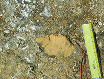 Figure 14. Coarse-grained Trenton limestone with Mid–Late Ordovician Prasopora sp. (Bryozoa) and breccia clasts of dolostone (Little Falls Dolostone?) at 42° 59.977’N, 74° 03.180’W in graben no. 4 along the Hoffmans Fault (see Figure 2 for location). The breccia suggests that the graben was active during Trenton deposition. The ruler is 15 cm (6 in.) long, and the numbered divisions on the right side of the ruler are in centimeters. Photograph by Robert Jacobi.
The grabens along the Saratoga-McGregor, Hoffmans, and associated faults reach far into the Proterozoic massif of the Adirondack dome (Figure 2); this reach suggests significant throw along these grabens in the Adirondack dome. However, the map pattern of the lower contact of the upper Cambrian Beekmantown Group does not reflect the deep incursion into the Adirondack dome. Rather, the contact displays relatively minor offset across the Hoffmans Fault west-northwest of Saratoga Springs (e.g., Fisher, 1980). If this map pattern is correct (the outcrop is quite sporadic in this region), then the grabens have a geometry similar to those observed in the 3-D seismic reflection surveys, in that major throw is observed on the Proterozoic–Cambrian contact and significantly less throw is observed upsection, in this ![]() case
case![]() at the Beekmantown level (Furongian–Lower Ordovician). If the mapped contacts are correct, then these grabens formed primarily during the Furongian to Early Ordovician.
at the Beekmantown level (Furongian–Lower Ordovician). If the mapped contacts are correct, then these grabens formed primarily during the Furongian to Early Ordovician.
In contrast to these proposed Ordovician ages, Valentino et al. (2012) suggested that the strike-slip component of motion was related to Cretaceous uplift of the Adirondack dome, since (1) fission-track dating (Roden-Tice et al., 2000; Roden-Tice and Tice, 2005) suggests diachronous cooling histories across the faults and (2) the regional stress field in the Cretaceous would have promoted left-lateral motion on the north-northeast–striking faults.
The Taconic and cumulative magnitude of transcurrent motion that occurred on these oblique-slip faults is unknown. For the Dolgeville and Hoffmans Faults, only a minor amount of Taconic and younger strike-slip motion might be inferred from the gentle plunge of axes of large (meso- to macroscale) drag folds that involve Ordovician Utica and Schenectady strata. In the Adirondack dome at Piseco Lake (Figure 2), the north-northeast–striking Indian Lake Fault (a probable northerly continuation of the Little Falls Fault) appears to offset the Shawinigan Piseco Antiform axis 3.5 km in a left-lateral sense (figure 14 in Valentino et al., 2012), and farther north at Indian Lake, the Indian Lake Fault system similarly offsets another possible Shawinigan antiformal axis 3 km in a left-lateral sense (Valentino et al., 2011, 2012, 2019). However, south of Piseco Lake, Valentino et al.’s (2019) detailed geologic map (their figure 4) shows little offset (0–0.5 km) of the east-west–trending Shawinigan Piseco shear zone across the Indian Lake Fault, suggesting that the 3–3.5 km of left-lateral motion on the Indian Lake Fault was transferred to the Piseco shear zone (Valentino et al., 2012) or that the 2.5–3 km of left-lateral motion predates the Shawinigan Piseco shear zone.
RHOMBOCHASMS AND RESTRAINING BENDS IN VEINS THAT SUGGEST STRIKE-SLIP MOTION ON HOFFMANS FAULT, MOHAWK VALLEY, NEW YORK STATE
Structures associated with Hoffmans Fault in Wolf Hollow (Figure 15) indicate that both strike-slip and dip-slip motion occurred on Hoffmans Fault. These structures include (1) drag folds in the down-dropped Utica and Lorraine Groups against the flat-lying carbonate succession of the Little Falls Dolostone to Trenton Group, (2) heavily veined shale, (3) a thin zone of scaly cleaved melange, (4) a heavily fractured zone, and (5) a small number of faults with minor throw (on the order of a centimeter). The steeply dipping veins that strike collinearly with the strike of the fault display stepovers with both restraining bends (Figure 15A) and releasing bends (Figure 15B) that suggest both left- and right-lateral motion along the fault zone. An approximately 5-cm drag fold with a vertically plunging axis and an axial surface parallel to the veins also indicates left-lateral motion (Figure 15C). Dip-slip motion is inferred from downdip plunging slickenfibers (Figure 15C), which is consistent with observed thickening of the Trenton and Utica succession on the eastern, downthrown side of this fault (Jacobi and Mitchell, 2018, figure 5 therein).
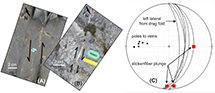 Figure 15. Kinematic indicators of veins on outcrop pavement along the Hoffmans Fault in Wolf Hollow, New York (for location, see black circle on Hoffmans Fault in Figure 2). (A) Restraining bend in vein (at label no. 4) where the vein is thinner at the right step than along the longer, northerly striking segments of the vein. The right-stepping restraining bend indicates left-lateral motion. View down onto outcrop pavement. Photograph by Robert Jacobi. (B) Releasing bends (rhombochasms) in a vein (at sites with arrows) wherein the vein is thicker at the right step than along the longer, more northerly striking segments of the vein. Right-stepping releasing bends indicate right-lateral motion. Photograph by Robert Jacobi. (C) Stereonet displaying orientations of veins and slickenfibers at a small outcrop in the ditch alongside the Wolf Hollow Road. The veins strike northerly (planes and poles to the veins), and one vein has a small drag fold of Utica Group shale along the vein (plane indicated by “left lateral from drag fold”). The slickenfibers plunge both along strike and downdip, indicating both strike-slip and dip-slip motion. The along-strike plunge is consistent with the releasing and restraining bend orientations.
The strike-slip motion inferred from the vertically plunging fold axes and the veins with rhombochasms are consistent with the motion inferred from the seismic data and from the map patterns. However, the outcrop data are not a compelling argument for a Taconic age of strike-slip motion since the age of the veins is not known and since multiple sense of motions are inferred from vein crosscutting, abutting, and stepover relationships (e.g., Agle et al., 2006a, b; Hrywnak et al., 2014; Jacobi et al., 2015). In fact, the U/Pb ratio of a sample from one vein in a nearby core falls on an isochron that yields a Middle–Late Devonian age (Jacobi et al., 2018).
DISCUSSION
The relay ramps observed in the 3-D seismic survey in western Pennsylvania occur at terminations of straight fault segments that offset the Onondaga Limestone. The presence of relay ramps suggest that the fault segments first formed in an extensional environment. Such an environment could be expected in local salt and mud withdrawal tectonics, but could the extension also represent a more-regional stress field? We have proposed in the past that other nearby faults in western Pennsylvania initiated essentially as slump faults bounding slump blocks (“floats” in the terminology of Hudec et al., 2011) above the ductile upper Silurian Vernon and Syracuse evaporite and mudstone succession of the Salina Group (Jacobi et al., 2013, 2015). Back-rotated fault blocks bounded by these faults suggest slumping occurred on an easterly dipping slope down into the basin toward the hinterland. This basinal slope direction is based on an easterly thickening sedimentary wedge between the Middle Devonian Onondaga and Tully Limestones observed both in 2-D seismic reflection profiles (Jacobi et al., 2013, 2015) and in outcrop and well data (e.g., Smith et al., 2019). This model suggests that the extensional stress field was regional.
Based on probable Upper Devonian sedimentary infill into the associated grabens, this fault activity occurred in the Neoacadian (Jacobi et al., 2013, 2015; Gao at al., 2020). Reactivated Iapetan-opening faults that pass up through the section from the Proterozoic to the Salina Group controlled the boundaries of deep fault blocks below the Salina section and the rotation of these blocks. Motion on these faults and fault blocks is hypothesized to have influenced the position of the overlying slump blocks (or floats). Because the slump block faults above the Salina Group are in general vertical alignment with the deep faults below the Salina Group, most of the blocks apparently experienced only minor translation downslope from fault block rotation. Exceptions include the more-ductile slump masses in the Salina that may have flowed downslope 2–6 km (Jacobi et al., 2013).
This model of Neoacadian initial development of faults and associated grabens in the western region of the Appalachian Basin in Pennsylvania is counter to the prevailing model for the northern part of the Pennsylvania Appalachian Basin that suggests the structures above the Salina section developed during compression in the Alleghanian orogeny (e.g., Frey, 1973; Sak et al., 2012; Mount, 2014; Gillespie et al., 2015). (Note that Gao et al., 2020, incorrectly indicated that Frey, 1973, Mount, 2014, and Gillespie et al., 2015, ascribed the deformation to the Acadian Orogeny.)
In the Alleghanian orogeny model, inward-facing kink-band sets and box folds form grabens that typify the structures between the Salina evaporites and the Devonian Tully Limestone (Gillespie et al., 2015). The kink bands are approximately 50–100 m wide, and the grabens formed by the kink-band sets have approximately a 400-m to 3-km width at the top of the Marcellus Formation (Gillespie et al., 2015). Compression and transport above the salt decollement developed in response to Alleghanian westward thrusting in the fold-thrust belt where the upper plate slipped northwesterly beyond the Allegheny Front (Sak et al., 2012; Mount, 2014; Gillespie et al., 2015). We have also observed similar inward-facing kink-band sets, but they do not appear to be prevalent in the 3-D seismic survey discussed in this paper nor on 2-D seismic reflection lines where the rotated fault blocks occur.
We suggest that the structures analyzed in this paper initiated in the Neoacadian during a regional (trans)extensional event and developed further during the Alleghanian orogeny under compressive or transpressional conditions. The difference between our model and the purely Alleghanian models is that our model suggests the deformation began during the Neoacadian orogeny, not the Alleghanian orogeny. A second difference is that in the purely Alleghanian models, the Alleghanian structures above the Salina Group are decoupled from faults below the Salina Group that extend downward into Proterozoic rocks. In contrast, in our model, Neoacadian slumping and gliding above (and within) the Salina Group were localized and influenced by dip changes on fault blocks below the Salina Group. These fault block rotations resulted from reactivation of Iapetan-opening faults in the Neoacadian. This foreland basin model with extension during Neoacadian basinal deepening to the east followed by encroaching Alleghanian compressional tectonics is consistent with older proposals for the development of the Appalachian Basin (e.g., Ettensohn, 1985, 2005).
How prevalent are the relay ramps in the northern Appalachian Basin? The answer cannot be determined conclusively from the limited number of available 3-D seismic surveys. In other 3-D surveys we studied in western Pennsylvania, narrow, relatively short relay ramps occur at small fault stepovers that do not affect the linearity of the near-surface fold axes. In central Pennsylvania, no relay ramps were reported in a small 3-D seismic survey (Gao et al., 2020). In the northern tier of Pennsylvania (largely Bradford County; Figure 1), Mount (2014) did not report large-scale relay ramps in 3-D seismic data. In another 3-D seismic survey at an undisclosed location in the eastern part of the northern tier of Pennsylvania (Gillespie et al., 2015), relay ramps were also not reported but may be evident in the northeastern part of the 3-D Onondaga Limestone surface (their figure 8).
In the absence of 3-D seismic surveys, two approaches allow us to speculate where large-scale relay ramps are more likely to occur. The formation of large-scale relay ramps has at least two contributing factors: (1) an extensional or transtensional environment, perhaps accentuated by local uplift, and (2) termination in map view of the anticline and associated border faults at the Onondaga Limestone level. The termination is manifested near the surface by either a sharp jog in the near-surface fold axis (as in Figure 4) or a termination of the near-surface fold axis.
The fairly linear near-surface anticline axes in parts of western Pennsylvania and the northern tier of Pennsylvania (Figure 1) suggest that in these areas relay ramps do not occur at the large scale we portray. In contrast, beneath a few sharp swings in orientation of near-surface anticline axes (as in Figure 4), 2-D seismic lines display the Onondaga surface stepping down across two or more faults. We infer relay ramps from these relationships in both western and northern Pennsylvania.
Cross-strike alignments of these fold-axis terminations (or abrupt swings) coincide with, and have been used to trace, some CSDs (Figure 1; e.g., Rodgers and Anderson, 1984). In the northern and central Appalachian Basin, CSDs were defined by lineaments recognized in gravity, aeromagnetics, topography, remotely sensed images, structural, seismic, and stratigraphic data (e.g., Wheeler, 1980; Parrish and Lavin, 1982; Rodgers and Anderson, 1984; Canich and Gold, 1985; Southworth, 1987; Harper, 1989; Shumaker and Wilson, 1996; Pohn, 2000; Gao et al., 2020). The CSDs represent either zones of steeply dipping, north- to northwest-striking multiply reactivated fault systems that initiated during Iapetan-opening or lateral ramps of thrusts (e.g., Rodgers and Anderson, 1984; Harper, 1989; Pohn, 2000; Jacobi, 2002). Since large-scale relay ramps can occur in regions marked by the terminations or jogs of near-surface anticlines (such as in Figure 4), CSDs may preferentially mark regions of relay ramps. The locations of Neoacadian fold terminations and associated relay ramps at CSDs were influenced by differential Neoacadian adjustments and uplift of fault blocks partly demarcated by the CSDs (e.g., Harper, 1989; Gao et al., 2020).
Uplift accompanying reactivated Iapetan-opening-Rome trough faults could have stimulated the development of extensional structures (including relay ramps) as a result of (1) a steepening basinal slope, (2) fault block rotations, and (3) seismicity. A proposed Middle Devonian paleotopographic high in western Pennsylvania (Williams and Bragonier, 1974; Parrish and Lavin, 1982; Harper, 1999; Lash and Engelder, 2011) is marked by the Kane gravity high (Figure 1; e.g., Parrish and Lavin, 1982; Shumaker and Wilson, 1996) that overlaps a region where the Middle Devonian Oriskany Sandstone is absent (Figure 1; e.g., Kostelnik and Carter, 2009; Lash and Engelder, 2011). Uplifts in different regions are indicated by other Middle Devonian strata, such as the lowest member of the Marcellus Formation, the Union Springs Member (Figure 1; Lash and Engelder, 2011). Although uplift is not as evident in western Pennsylvania during the Late Devonian, limited Late Devonian uplift may have occurred there as well (Harper, 1989, personal communication, 2020), as it did in New York (Jacobi and Fountain, 1993, 1996, 2002; Smith and Jacobi, 1998, 2001; Jacobi, 2002; Evenick et al., 2005). In that ![]() case
case![]() , uplift along reactivated Iapetan-opening faults in western Pennsylvania likely was a contributing factor for the formation of relay ramps in western Pennsylvania compared to the region of Mount’s (2014) and Gillespie et al.’s (2015) 3-D seismic surveys that are more than 100 km (>62 mi) away from the regions of uplift in western Pennsylvania. The uplift might be the manifestation of a peripheral bulge that developed in response to plate loading and consequent downwarp farther east (e.g., Lash and Engelder, 2011).
, uplift along reactivated Iapetan-opening faults in western Pennsylvania likely was a contributing factor for the formation of relay ramps in western Pennsylvania compared to the region of Mount’s (2014) and Gillespie et al.’s (2015) 3-D seismic surveys that are more than 100 km (>62 mi) away from the regions of uplift in western Pennsylvania. The uplift might be the manifestation of a peripheral bulge that developed in response to plate loading and consequent downwarp farther east (e.g., Lash and Engelder, 2011).
A factor that does not appear to have a significant influence on relay ramp recognition is the distance from the Allegheny Front. Since Wiltschko and Chapple (1977) showed that the ratio of structural relief to salt thickness of anticlines in the Appalachian Basin increases toward the Allegheny Front, it is possible that 3-D seismic surveys close to the Allegheny Front had Devonian Neoacadian structures that were completely overprinted by Carboniferous–Permian Alleghanian strain. However, the 3-D seismic survey in western Pennsylvania with the large-scale relay ramps is about the same distance from the Allegheny Front (measured orthogonal to the Front) as Mount’s (2014) 3-D survey that has no recognized relay ramps and only 20 km (12 mi) further away from the Allegheny Front than Gillespie et al.’s (2015) survey with small unremarked possible relay ramps.
If the Neoacadian fault model proposed herein is correct, then the faults began developing before oil and gas generation. Based on the sediment infills, the age of faulting ranged from circa 380 to 370 Ma (Jacobi et al., 2012, 2013, 2018). Subsidence curves suggest that oil generation in the Marcellus Formation in the area of the 3-D seismic survey began circa 360 Ma, with peak oil generation between circa 360 and 310 Ma (Jacobi et al., 2012, 2013, 2018). Gas generation followed the oil generation from circa 360 to 270 Ma. This model is confirmed by bitumen-filled veins associated with the faults in core (e.g., Jacobi et al., 2018). These faults thus were most likely conduits for oil and gas ![]() migration
migration![]() away from the Marcellus Formation; the stratigraphically higher sandstones such as the Devonian Elk and Bradford sandstones were probably charged in this manner.
away from the Marcellus Formation; the stratigraphically higher sandstones such as the Devonian Elk and Bradford sandstones were probably charged in this manner.
We interpret a more than 100-yr-old geological sketch from Cushing and Ruedemann (1914) as portraying a Taconic relay ramp along the north-northeast–striking Saratoga-McGregor Fault in the Mohawk Valley (Figure 9). The relay ramp interpretation is consistent with the detailed structural analysis of more than 50 kinematic indicators in the Utica Group in an unoriented core taken farther south on a main splay of the same fault (Hanson et al., 2010, 2011; location of core indicated by star in Figures 2, 10). None of the kinematic indicators imply strike-slip motion; rather, all indicate either downdip or updip motion (Hanson et al., 2010, 2011). The dip-slip movement on the Saratoga-McGregor Fault is also consistent with older convergence models of the Taconic Orogeny (e.g., Fisher, 1979; Bradley and Kidd, 1991). However, the dip-slip motion does not agree with the proposed local transtensional motion suggested by presence of rhombochasms along north-northeast–striking faults to the west, such as Hoffmans Fault. Perhaps the core on the Saratoga-McGregor Fault (location indicated by star in Figure 2) actually passed through a dip-slip fault associated with a stepover on the Saratoga-McGregor Fault or not all the north-northeast–striking faults experienced the same sense of motion.
If we are correct that the Taconic structures in the 3-D seismic survey in New York State represent rhombochasms along north-northeast––striking faults, in a local transtensional environment, then the strike-slip component in that region was right lateral. In contrast, if the small grabens at left steps in north-northeast–striking faults in the southern Adirondacks also represent rhombochasms, then these faults experienced left-lateral motion. It is difficult to determine the age of these grabens, but Mid–Late Ordovician Prasopora (Bryozoa) in a breccia exposed in graben no. 4 along Hoffmans Fault indicates that graben no. 4 was active during the Mid–Late Ordovician Taconic Orogeny. This age is similar to that of the faults in the 3-D seismic survey and to other faults in the Mohawk Valley that are associated with Trenton–Black River breccias (e.g., Bradley and Kidd, 1991).
The proposed Taconic motion on the north-northeast–striking faults in the southern Adirondacks is opposite to that of the northeast-striking faults inferred from the 3-D seismic survey. If this assessment of opposite sense of motions is correct, and they are Taconic, then we propose that the opposite sense of strike-slip motion for Taconic times reflects escape tectonics away from the New York promontory. The New York promontory is a relict headland on the ragged Laurentian margin that developed during the breakup of Rodinia and the opening of the Iapetus (e.g., Thomas, 2006; Hibbard and Karabinos, 2013). The New York promontory influenced deposition along the passive Laurentian margin in the Cambrian and Early Ordovician (e.g., Hibbard and Karabinos, 2013; Landing and Webster, 2018). Later, the promontory would have functioned as a structural buttress during the Taconic collisional events when sedimentary terranes and microcontinent-floored arcs approached and impinged on the Laurentian margin (e.g., Marshak, 2004).
Not only did the north-northeast–striking faults not all share the same sense of motion, but it also appears that they all did not sustain motion at the same time in (1) the Mohawk Valley region, based on localized slumps (Jacobi and Mitchell, 2002; Jacobi et al., 2006); (2) the region southwest of the Mohawk Valley, based on detailed analyses of growth fault geometries observed in 3-D seismic reflection data (Jacobi, 2011, 2012); and (3) central and western New York State, based on detailed field stratigraphy and 2-D seismic reflection profiles (Jacobi and Fountain, 1993, 2002).
It is not surprising that faults with the same orientation, and in some cases within the same general structural domain, experienced different timings and/or sense of motion. The Mohawk Valley region has been affected by a complex sequence of tectonic events, including the Taconic, Salinic, Neoacadian, and Alleghanian orogenies as well as rifting of the present-day Atlantic, Cretaceous and younger uplift, and glacial loading and rebound (e.g., Bosworth and Putman, 1986; Valentino et al., 2012; Jacobi and Ebel, 2019). Additionally, in the Appalachian Basin of the Mohawk Valley region, the different timings of motion on different faults during a single orogeny may be a reflection of the (1) relatively low stress differential across the basin, compared to orogenic belts (Jacobi and Fountain, 1993, 2002) and/or (2) evolution of structures such as the abandonment of faults as a rhombochasm develops. The different senses of motion on faults with the same orientation, such as dip slip for some faults and strike slip, oblique slip, as well as dip slip for other faults, may be related to (1) incomplete or incorrect understanding concerning the geometry of the faults because of poor outcrop or 2-D seismic data, (2) different ages for the dip-slip versus strike-slip motions, or (3) stress field deviations across the region related to large-scale crustal block faults and/or stress release on these faults, as has been proposed for varying fracture orientations in the Mohawk Valley (Jacobi, 2014).
Careful analyses of thickness variations of reflector intervals across the faults in 3-D surveys can reveal the timing and sense of dip-slip motion of the suite of faults in the target area. Additionally, small thickness variations in particular reflector intervals at fault stepovers can indicate the timing and sense of motion for a component of strike-slip faulting, as shown above for the Mohawk Valley region. Comparison of the thickness variations across the faults in the seismic survey will allow determination of the pervasiveness of a particular motion history in the target area.
An important implication for these variable timings of motion and variable senses of motion on faults in a relatively local region is that the fault motion history inferred from a few data points on a few faults should not be extrapolated with any degree of confidence to entire networks of faults in the northern Appalachian Basin. Blanket generalizations can lead to incorrect assumptions concerning the (1) fault motion history of unstudied individual faults and (2) consequent faulting factors such as timing of hydrocarbon and hydrothermal fluid ![]() migration
migration![]() along particular faults (Jacobi, 2011, 2012). These different timings of fault motion can lead to significant local compartmentalization.
along particular faults (Jacobi, 2011, 2012). These different timings of fault motion can lead to significant local compartmentalization.
CONCLUSIONS
Structures in the northern Appalachian Basin generally have been ascribed to compressional tectonics related to the Alleghanian orogeny. Relay ramps implying local extensional stress conditions and rhombochasms implying strike-slip motion have not been reported in the northern Appalachian Basin. However, we have recognized relay ramps in a 3-D seismic survey in the Appalachian Basin of western Pennsylvania. The relay ramps are observed in structure maps of the Devonian Onondaga Limestone (which underlies the Marcellus Formation).
These relay ramps occur where the border faults on the southeastern side of Salina Group salt and mudstone pillows terminate. The relay ramps have length/width ratios consistent with those observed in other basins and in physical models. Devonian sediment infill in adjacent grabens suggest that the features initiated during the Neoacadian orogeny, rather than the Alleghanian orogeny. The proposed Neoacadian origin of these faults implies that these faults initiated before the time of Marcellus oil and gas generation. The faults were thus most likely ![]() migration
migration![]() pathways for hydrocarbon out of the source beds. Bitumen in veins associated with the faults supports this hypothesis.
pathways for hydrocarbon out of the source beds. Bitumen in veins associated with the faults supports this hypothesis.
Reactivated Iapetan-opening faults that pass up through the section from the Proterozoic to the Salina Group commonly are aligned with the fault systems above the Salina Group. Motion on the deeper faults and fault blocks is hypothesized to have influenced the position of the overlying slump blocks. Because the deep faults below the Salina Group are in general vertical alignment with the slump block faults above the Salina Group, most of the blocks apparently experienced only minor translation downslope from fault block rotation.
A relay ramp interpretation is also proposed for a dipping fault block of Ordovician carbonates located along the north-northeast–striking Saratoga-McGregor Fault in the Mohawk Valley region at Saratoga, New York. In contrast, a series of stepovers on another Taconic fault in the Mohawk Valley displays no significant relay ramp. Possible contributing factors for this lack of observed relay ramps include the (1) stepovers evolved to the final, faulted, stage of relay ramp development and (2) semilithified nature of the Utica black shales at the time of deformation resulted in narrow zones of steeply drag-folded shale.
Rhombochasms are inferred from a small 3-D seismic survey in the Appalachian Basin of eastern New York State southwest of the Mohawk Valley region. The deepest extents of the grabens occur at right stepovers of en-echelon, northeast-striking faults. Possible Riedel shears accompany the graben fault systems. The rhombochasms involve the Trenton and Utica Groups and indicate a component of right-lateral motion during the Taconic Orogeny. To the north, small grabens mapped within the Proterozoic terrane of the Adirondack dome contain Cambrian–Ordovician sediments and occur at left steps of north-northeast–striking faults. These grabens may represent rhombochasms that developed during left-lateral motion on the north-northeast–striking faults. Mid–Upper Ordovician breccia in one of the grabens suggest that at least this graben was active during the Taconic Orogeny. Right-lateral motion on northeast-striking faults to the south of the New York promontory and left-lateral motion on north-northeast–striking faults to the north of the New York promontory suggest that the divergent strike-slip motion could be related to escape tectonics away from the New York promontory during convergence tectonics.
That similarly striking faults in the northern Appalachian Basin can have different senses of motion and timings requires careful consideration when attempting to build a basin model from a few fault examples. Blanket generalizations can lead to incorrect assumptions concerning consequent faulting factors, such as timing of hydrocarbon ![]() migration
migration![]() along particular faults. The different fault histories will also contribute to significant compartmentalization. The high fracture porosity that can be associated with rhombochasms and Riedel shears make these newly recognized features an attractive target.
along particular faults. The different fault histories will also contribute to significant compartmentalization. The high fracture porosity that can be associated with rhombochasms and Riedel shears make these newly recognized features an attractive target.
REFERENCES CITED
Acocella, V., P. Morvillo, and R. Funiciello, 2005, What controls relay ramps and transfer faults within rift zones? Insights from analogue models: Journal of Structural Geology, v. 27, no. 3, p. 397–408, doi:10.1016/j.jsg.2004.11.006.
Agle, P., R. D. Jacobi, G. E. Cross, and C. E. Mitchell, 2005, Fractures and veins related to Taconic-aged faults in the Mohawk Valley (abs.): Geological Society of America Abstracts with Programs, v. 37, no. 1, p. 3.
Agle, P., R. D. Jacobi, and C. Mitchell, 2006a, Fault-related fractures, veins, and fluid ![]() migration
migration![]() ; Mohawk Valley, NYS (abs.): Geological Society of America Abstracts with Programs, v. 41, no. 2, p. 85.
; Mohawk Valley, NYS (abs.): Geological Society of America Abstracts with Programs, v. 41, no. 2, p. 85.
Agle, P., R. D. Jacobi, C. Mitchell, R. Nyahay, B. Slater, and L. Smith, 2006b, Faulting and mineralization in the Cambro-Ordovician section of the Mohawk Valley, in R. Jacobi, ed., New York State Geological Association field trips: New York State Geological Association 78th Annual Meeting, Buffalo, New York, October 6–8, 2006, p. 1–53.
Beardsley, R. W., R. C. Campbell, and M. A. Shaw, 1999, Appalachian plateau, in C. H. Schultz, ed., The geology of Pennsylvania: Harrisburg, Pennsylvania, Pennsylvania Geological Survey, p. 287–297.
Benoit, M. H., C. Ebinger, and M. Crampton, 2014, Orogenic bending around a rigid Proterozoic magmatic rift beneath the Central Appalachian Mountains: Earth and Planetary Science Letters, v. 402, p. 197–208, doi:10.1016/j.epsl.2014.03.064.
Bird, J. M., and J. F. Dewey, 1970, Lithosphere plate-continental margin tectonics and the evolution of the Appalachian Orogen: Geological Society of America Bulletin, v. 81, no. 4, p. 1031–1060, doi:10.1130/0016-7606(1970)81[1031:LPMTAT]2.0.CO;2.
Bosworth, William, and G. W. Putman, 1986, Ductile to brittle strain history of the McGregor fault, east-central New York: American Journal of Science, v. 286, no. 7, p. 576–589, doi:10.2475/ajs.286.7.576.
Bradley, D. C., and W. S. F. Kidd, 1991, Flexural extension of the upper continental crust in collisional foredeeps: Geological Society of America Bulletin, v. 103, no. 11, p. 1416–1438, doi:10.1130/0016-7606(1991)103<1416:FEOTUC>2.3.CO;2.
Canich, M. R., and D. P. Gold, 1985, Structural features in the Tyrone-Mt. Union lineament, across the Nittany Anticlinorium in central Pennsylvania, in D. P. Gold, ed., Central Pennsylvania revisited: Guidebook: 50th Annual Field Conference of Pennsylvania Geologists, State College, Pennsylvania, October 3–5, 1985, p. 120–137.
Childs, C., W. R. Bailey, C. G. Bonson, A. Nicol, and J. J. Walsh, 2003, A 3-D perspective on the formation of segmented normal fault arrays: Tectonic Studies Group Annual Meeting, Liverpool, United Kingdom, January 2003, accessed March 5, 2015, https://www.fault-analysis-group.ucd.ie/Lectures/47TSG2D3D.htm.
Choi, E., L. Seeber, M. S. Steckler, and R. Buck, 2011, One‐sided transform basins and “inverted curtains”: Implications for releasing bends along strike‐slip faults: Tectonics, v. 30, 11 p., doi: 10.1029/2011TC002943.
Christie-Blick, N., and K. T. Biddle, 1985, Deformation and basin formation along strike-slip faults, in K. T. Biddle and N. Christie-Blick, eds., Strike-slip deformation, basin formation, and sedimentation: Tulsa, Oklahoma, SEPM Special Publication 37, p. 1–34, doi:10.2110/pec.85.37.0001.
Commins, D., S. Gupta, and J. Cartwright, 2005, Deformed streams reveal growth and linkage of a normal fault array in the Canyonlands graben, Utah: Geology, v. 33, no. 8, p. 645–648, doi:10.1130/G21433AR.1.
Crider, J. G., 2001, Oblique slip and the geometry of normal-fault linkage: Mechanics and a ![]() case
case![]() study from the Basin and Range in Oregon: Journal of Structural Geology, v. 23, no. 12, p. 1997–2009, doi:10.1016/S0191-8141(01)00047-5.
study from the Basin and Range in Oregon: Journal of Structural Geology, v. 23, no. 12, p. 1997–2009, doi:10.1016/S0191-8141(01)00047-5.
Cross, G. E., R. D. Jacobi, L. Smith, R. Nyahay, and M. Lupulescu, 2004, Taconic faults and mineralization: Outcrop analog for Ordovician hydrocarbon plays in the Appalachian Basin (abs.): Geological Society of America Abstracts with Programs, v. 36, no. 2, p. 146.
Cunningham, W. D., and P. Mann, 2007, Tectonics of strike-slip restraining and releasing bends: Geological Society, London, Special Publications 2007, v. 290, p. 1–12.
Cushing, H. P., 1905, Geology of the vicinity of Little Falls, Herkimer County: Albany, New York, New York State Museum Bulletin 77, 95 p.
Cushing, H. P., and R. Ruedemann, 1914, Geology of Saratoga Springs and vicinity: Albany, New York, New York State Museum Bulletin 169, 177 p.
Dawers, N. H., and J. R. Underhill, 2000, The role of fault interaction and linkage in controlling syn-rift stratigraphic sequences: Late Jurassic, Statfjord East area, northern North Sea: AAPG Bulletin, v. 84, p. 45–64.
Di Bucci, D., B. Massa, and A. Zuppetta, 2006, Relay ramps in active normal fault zones: A clue to the identification of seismogenic sources (1688 Sannio earthquake, Italy): Geological Society of America Bulletin, v. 118, no. 3–4, p. 430–448, doi:10.1130/B25783.1.
Dutton, D. M., and B. D. Trudgill, 2009, Four-dimensional analysis of the Sembo relay system, offshore Angola: Implications for fault growth in salt-detached settings: AAPG Bulletin, v. 93, no. 6, p. 763–794, doi:10.1306/02230908094.
Ettensohn, F. R., 1985, The Catskill delta complex and the Acadian orogeny: A model, in D. L. Woodrow and W. D. Sevon, eds., The Catskill Delta: Boulder, Colorado, Geological Society of America Special Paper 201, p. 39–49, doi:10.1130/SPE201-p39.
Ettensohn, F. R., 2004, Modeling the nature and development of major Paleozoic clastic wedges in the Appalachian Basin, USA: Journal of Geodynamics, v. 37, no. 3–5, p. 657–681, doi:10.1016/j.jog.2004.02.009.
Ettensohn F. R., 2005, The sedimentary record of foreland-basin, tectophase cycles: Examples from the Appalachian Basin, USA, in J. M. Mabessoone and V. H. Neumann, eds., Amsterdam, Elsevier Developments in Sedimentology 57, p. 139–172.
Ettensohn, F. R., 2008, The Appalachian foreland basin in eastern United States, in A. D. Miall, ed., The sedimentary basins of the United States and Canada: Amsterdam, Elsevier Sedimentary Basins of the World, v. 5, p. 105–179, doi:10.1016/S1874-5997(08)00004-X.
Ettensohn, F. R., and C. E. Brett, 2002, Stratigraphic evidence from the Appalachian Basin for continuation of the Taconian orogeny into Early Silurian time, in C. E. Mitchell and R. D. Jacobi, eds., Taconic convergence: Orogen, foreland and craton: Physics and Chemistry of the Earth, Parts A/B/C, v. 27, no. 1–3, p. 279–288, doi:10.1016/S1474-7065(01)00010-9.
Evenick, J. C., R. D. Jacobi, G. S. Baker, and C. E. Mitchell, 2005, Subsurface evidence for faults in the Appalachian Basin, western New York State: Northeastern Geology and Environmental Sciences, v. 27, no. 1, p. 1–17.
Faill, R. T., and R. P. Nickelsen, 1999, Appalachian mountain section of the Ridge and Valley province, in C. H. Shultz, ed., The geology of Pennsylvania: Harrisburg, Pennsylvania, Pennsylvania Geological Survey, p. 269–285.
Faulds, J. E., and R. J. Varga, 1998, The role of accommodation zones and transfer zones in the regional segmentation of extended terranes, in J. E. Faulds and J. H. Stewart, eds., Accommodation zones and transfer zones: The regional segmentation of the Basin and Range Province: Boulder, Colorado, Geological Society of America Special Paper 323, p. 1–45, doi:10.1130/0-8137-2323-X.1.
Fisher, D. W., 1957, Mohawkian (Middle Ordovician) biostratigraphy of the Wells Outlier Hamilton County, New York: Albany, New York, New York State Museum and Science Service Bulletin 359, 33 p.
Fisher, D. W., 1979, Folding in the foreland, Middle Ordovician Dolgeville facies, Mohawk Valley, New York: Geology, v. 7, no. 9, p. 455–459, doi:10.1130/0091-7613(1979)7<455:FITFMO>2.0.CO;2.
Fisher, D. W., 1980, Bedrock geology of the Central Mohawk Valley, New York: Albany, New York, New York State Museum and Science Service, Map and Chart Series 33, 44 p., scale 1:48,0000, 2 sheets.
Fossen, H., and A. Rotevatn, 2016, Fault linkage and relay structures in extensional settings—A review: Earth-Science Reviews, v. 154, p. 14–28, doi:10.1016/j.earscirev.2015.11.014.
Frey, M. G., 1973, Influence of Salina salt on structure in New York-Pennsylvania part of Appalachian Plateau: AAPG Bulletin, v. 57, no. 6, p. 1027–1037.
Gao, D., E. Roberts, C. Geiger, and P. Sullivan, 2020, Acadian detachment and wrench faults in central Pennsylvania: Implications for the Marcellus Shale reservoir integrity and gas productivity in the hinge of the Pennsylvania salient: Interpretation, v. 8, no. 1, p. T151–T165, doi:10.1190/INT-2019-0110.1.
Gillespie, P., J. van Hagen, S. Wessels, and D. Lynch, 2015, Hierarchical kink band development in the Appalachian Plateau decollement sheet: AAPG Bulletin, v. 99, no. 1, p. 51–76, doi:10.1306/07251413222.
Gürboğa, Ş., 2014, Structural analyses of Şaphane relay ramps and fault linkage evolution in active extensional regime, western Turkey: Turkish Journal of Earth Sciences, v. 23, no. 6, p. 615–626, doi:10.3906/yer-1405-16.
Hanson, S. L., R. D. Jacobi, and C. E. Mitchell, 2010, Structure and geochemistry of a Cambro-Ordovician 360m core from Saratoga Springs region, New York State: Implications for tectonics, gas exploration, and CO2 sequestration (abs.): AAPG Eastern Section Annual Meeting, Kalamazoo, Michigan, September 25–29, 2010, accessed September 20, 2011, http://www.searchanddiscovery.com/abstracts/pdf/2010/eastern/abstracts/ndx_hanson.pdf.
Hanson, S. L., R. D. Jacobi, and C. E. Mitchell, 2011, Structure and vein isotopes of a Cambro-Ordovician 360m Core from the Saratoga Springs region, New York State: Implications for Tectonics and Utica gas exploration (abs.): Geological Society of America Northeastern (46th Annual) and North-Central (45th Annual) Joint Meeting Abstracts with Programs, Pittsburgh, Pennsylvania, March 20–22, 2011, accessed September 15, 2011, https://gsa.confex.com/gsa/2011NE/webprogram/Paper185523.html.
Harper, J. A., 1989, Effects of recurrent tectonic patterns on the occurrence and development of oil and gas resources in western Pennsylvania: Northeastern Geology, v. 11, p. 225–245.
Harper, J. A., 1999, Devonian, in G. H. Shultz, ed., The geology of Pennsylvania: Harrisburg, Pennsylvania, Geological Survey Special Publication 1, p. 109–127.
Harrison, M. J., S. Marshak, and J. H. McBride, 2004, The Lackawanna synclinorium, Pennsylvania: A salt-collapse structure, partially modified by thin-skinned folding: Geological Society of America Bulletin, v. 116, no. 11–12, p. 1499–1514, doi:10.1130/B25400.1.
Hatcher, R. D. Jr., 2005, Southern and central Appalachians, in R. C. Selley, L. R. M. Cocks, and I. R. Plimer, eds., Encyclopedia of Geology: Amsterdam, Elsevier Ltd., p. 72–81, doi:10.1016/B0-12-369396-9/00408-1.
Hayman, N. W., and W. S. F. Kidd, 2002a, Reactivation of prethrusting, synconvergence normal faults as ramps within the Ordovician Champlain-Taconic thrust system: Geological Society of America Bulletin, v. 114, no. 4, p. 476–489, doi:10.1130/0016-7606(2002)114<0476:ROPSNF>2.0.CO;2.
Hayman, N. W., and W. S. F. Kidd, 2002b, The Champlain Thrust System in the Whitehall Shoreham area: Influence of pre- and post-thrust normal faults on the present thrust geometry and lithofacies distribution, in J. M. McLelland and P. Karabinos, eds., Guidebook for fieldtrips in New York and Vermont: Skidmore College, Saratoga Springs, New York: New England Intercollegiate Geological Conference 94th Annual Meeting and New York State Geological Association 74th Annual Meeting, Lake George, New York, September 27–29, 2002, Field Trip A7, p. 7-1–7-2.
Hibbard, J., and P. Karabinos, 2013, Disparate paths in the geologic evolution of the northern and southern Appalachians: A ![]() case
case![]() for inherited contrasting crustal/lithospheric substrates: Geoscience Canada, v. 40, no. 4, p. 303–317, doi:10.12789/geocanj.2013.40.021.
for inherited contrasting crustal/lithospheric substrates: Geoscience Canada, v. 40, no. 4, p. 303–317, doi:10.12789/geocanj.2013.40.021.
Hrywnak, A. E., R. D. Jacobi, K. W. Jones, and C. E. Mitchell, 2014, Hoffmans Fault: Tectonic history of a Taconic foreland basin fault in the Mohawk Valley (NYS), based on characteristics of fractures in Utica Shale core and outcrop (abs.): Geological Society of America Northeastern Section 49th Annual Meeting, Lancaster, Pennsylvania, March 23–25, 2014, Abstracts with Programs, v. 46, no. 2, p. 97.
Hudec, M. R., M. P. A. Jackson, B. C. Vendeville, D. D. Schultz-Ela, and T. P. Dooley, 2011, The salt mine: A digital atlas of salt tectonics: AAPG Memoir 99, 305 p.
Hunt, R., 2020, Machine-learning with multi-seismic attributes in Cambro-Ordovician carbonates of southwestern Pennsylvania: AAPG Search and Discovery article 42554, accessed June 13, 2021, https://www.searchanddiscovery.com/documents/2020/42554hunt/ndx_hunt.pdf.
Hus, R., V. Acocella, R. Funiciello, and M. De Batist, 2005, Sandbox models of relay ramp structure and evolution: Journal of Structural Geology, v. 27, no. 3, p. 459–473, doi:10.1016/j.jsg.2004.09.004.
Jacobi, R. D., 1981, Peripheral bulge - A causal mechanism for the Lower/Middle Ordovician unconformity along the western margin of the Northern Appalachians: Earth and Planetary Science Letters, v. 56, p. 245–251, doi:10.1016/0012-821X(81)90131-X.
Jacobi, R. D., 2002, Basement faults and seismicity in the Appalachian Basin of New York State: Tectonophysics, v. 353, no. 1–4, p. 75–113, doi:10.1016/0012-821X(81)90131-X.
Jacobi, R. D., 2010, Geophysical and geological evidence for arcuate Iapetan opening rift faults in the Pennsylvania Salient and New York recess: Implications for the ragged Laurentian margin: Albany, New York, New York State Energy Research and Development, Final Report, 42 p.
Jacobi, R. D., 2011, Faults in the Appalachian Basin of NYS (abs.): Geological Society of America Northeastern (46th Annual) and North-Central (45th Annual) Joint Meeting Abstracts with Programs, Pittsburgh, Pennsylvania, March 20–22, 2011, accessed July 5, 2021, https://gsa.confex.com/gsa/2011NE/webprogram/Paper185588.html.
Jacobi, R. D., 2012, Taconic convergence faults in the Mohawk Valley of New York State (abs.): Northeastern Section Geological Society of America Abstracts with Programs, Hartford, Connecticut, March 18–20, 2012, accessed August 25, 2021, https://gsa.confex.com/gsa/2012NE/webprogram/Paper200756.html.
Jacobi, R. D., 2014, Assessing the impact of fracture spacing and fracture patterns in the construction of a realistic fracture flow model (“fracture study”), NYSERDA agreement 22396: Albany, New York, New York State Energy Research and Development Authority, Revised Final Report, 219 p.
Jacobi, R. D., P. A. Agle, and C. E. Mitchell, 2005, Preliminary bedrock geology of the Little Falls 7.5′ quadrangle: Albany, New York, New York State Geological Survey, New York State Museum Open File Report 2019.5.1, 1 sheet.
Jacobi, R. D., and J. E. Ebel, 2019, Seismotectonic implications of the Berne earthquake swarms west-southwest of Albany, New York: Lithosphere, v. 11, no. 5, p. 750–764, doi:10.1130/L1066.1.
Jacobi, R. D., and J. C. Fountain, 1993, The southern extension and reactivations of the Clarendon-Linden Fault System: Géographie Physique et Quaternaire, v. 47, no. 3, p. 285–302, doi:10.7202/032958ar.
Jacobi, R. D., and J. C. Fountain, 1996, Determination of the seismic potential of the Clarendon-Linden Fault System in Allegany County, Final Report: Albany, New York, New York State Energy Research and Development Authority, 2106 p.
Jacobi, R. D., and J. C. Fountain, 2002, The character and reactivation history of the of the southern extension of the seismically active Clarendon-Linden Fault System, western New York State, in R. H. Fakundiny, R. D. Jacobi, and C. F. M. Lewis, eds., Neotectonics and seismicity in the eastern Great Lakes Basin: Tectonophysics, v. 353, p. 215–262, doi:10.1016/S0040-1951(02)00284-6.
Jacobi, R. D., J. Kim, P. A. Agle, M. Gale, L. Becker, C. Mitchell, and G. Smith, 2006, Generation of Lower Paleozoic carbonate reservoirs in the Appalachian Basin of New York State: Faults, timing, and the plate tectonic connection: Ontario-New York Oil and Gas 45th Annual Conference, Niagara Falls, Ontario, Canada, November 1–3, 2003, p. 1–36.
Jacobi, R. D., R. Mathur, A. Douds, T. Warner, J. Starr, and C. Willan, 2018, U-Pb calcite ages and the ![]() case
case![]() for Acadian structural development in the Appalachian basin: Implications for oil and gas
for Acadian structural development in the Appalachian basin: Implications for oil and gas ![]() migration
migration![]() (abs.): AAPG Eastern Section Annual Meeting Pittsburgh, Pennsylvania, October 7–11, 2018, p. 22–23, accessed June 18, 2021, https://www.searchanddiscovery.com/abstracts/html/2018/pittsburgh-90335/abstracts/2018.ES.56.html.
(abs.): AAPG Eastern Section Annual Meeting Pittsburgh, Pennsylvania, October 7–11, 2018, p. 22–23, accessed June 18, 2021, https://www.searchanddiscovery.com/abstracts/html/2018/pittsburgh-90335/abstracts/2018.ES.56.html.
Jacobi, R. D., and C. E. Mitchell, 2002, Geodynamical interpretation of a major unconformity in the Taconic Foredeep: Slides scar or onlap unconformity? in C. E. Mitchell and R. D. Jacobi, eds., Taconic convergence: Orogen, foreland basin, and craton: Physics and Chemistry of the Earth, v. 27, p. 169–201, doi:10.1016/S1474-7065(01)00006-7.
Jacobi, R. D., and C. E. Mitchell, 2018, Aseismic ridge subduction as a driver for the Ordovician Taconic orogeny and Utica foreland basin in New England and New York State, in R. V. Ingersoll, T. F. Lawton, and S. A. Graham, eds., Tectonics, sedimentary basins, and provenance: A celebration of William R. Dickinson’s career: Boulder, Colorado, Geological Society of America Special Paper 540, p. 617–659, doi:10.1130/2018.2540(27).
Jacobi, R. D., C. E. Mitchell, C. Brett, and G. Baird, 2002, Soft-sediment deformation and the Prospect Fault, Taconic convergence, Mohawk Valley, central New York State (abs.): Northeastern Section 37th Annual Meeting Geological Society of America Abstracts with Programs, Springfield, Massachussetts, March 25–27, 2002, v. 34, no. 1, p. A-73.
Jacobi, R. D., C. E. Mitchell, and W. S. F. Kidd, 2016, Albany nappes (not our elected officials), Argentina, and plate tectonic models: Implications from seismic and outcrop data in the Ordovician foreland basin of NYS (abs.): Northeast Section 51st Annual Meeting, Geological Society of America Abstracts with Programs, Albany, New York, March 21–23, 2016, v. 48, no. 2, Paper 30-4, accessed April 13, 2016, http://gsa.confex.com/gsa/2016NE/webprogram/Paper272786.html.
Jacobi, R. D., and G. Smith, 2000, Part I, core and cutting analyses, surface structure, faults and lineaments, and stratigraphic cross-sections based on previous investigations, in R. Jacobi, ed., Geologic investigation of the gas potential in the Otsego County region, eastern New York State Final Report: Albany, New York, New York State Energy Research and Development Authority, 85 p.
Jacobi, R. D., J. Starr, and C. Eckert, 2015, Relay ramps and rhombochasms: Step overs in the Marcellus and Utica of the Northern Appalachian Basin: AAPG Search and Discovery article 41727, accessed February 25, 2016, http://www.searchanddiscovery.com/pdfz/documents/2015/41727jacobi/ndx_jacobi.pdf.html.
Jacobi, R. D., J. Starr, D. Jackson, C. Eckert, and T. B. Warner, 2012, Acadian sliding and gliding: Anatomy of styles for gravitational fault development and hydrocarbon ![]() migration
migration![]() in the western Appalachian Foreland Basin of Pennsylvania and West Virginia (abs.): Geological Society of America Annual Meeting, Charlotte, North Carolina, November 4–7, 2012, Paper 205-9, accessed February 26, 2013, http://gsa.confex.com/gsa/2012AM/webprogram/Paper206706.html.
in the western Appalachian Foreland Basin of Pennsylvania and West Virginia (abs.): Geological Society of America Annual Meeting, Charlotte, North Carolina, November 4–7, 2012, Paper 205-9, accessed February 26, 2013, http://gsa.confex.com/gsa/2012AM/webprogram/Paper206706.html.
Jacobi, R. D., J. Starr, D. Jackson, C. Eckert, and T. B. Warner, 2013, Acadian sliding: Anatomy of styles for gravitational fault development and hydrocarbon ![]() migration
migration![]() in the western Appalachian Foreland Basin of Pennsylvania and West Virginia (abs.): AAPG Annual Convention and Exhibition, Pittsburgh, Pennsylvania, May 19–22, 2013, 8 p., accessed October 31, 2013, http://www.searchanddiscovery.com/pdfz/documents/2013/41126jacobi/ndx_jacobi.pdf.html.
in the western Appalachian Foreland Basin of Pennsylvania and West Virginia (abs.): AAPG Annual Convention and Exhibition, Pittsburgh, Pennsylvania, May 19–22, 2013, 8 p., accessed October 31, 2013, http://www.searchanddiscovery.com/pdfz/documents/2013/41126jacobi/ndx_jacobi.pdf.html.
Kay, G. M., 1937, Stratigraphy of the Trenton group: Geological Society of America Bulletin, v. 48, no. 2, p. 233–302, doi:10.1130/GSAB-48-233.
Kidd, W. S. F., A. Plesch, and F. W. Vollmer, 1995, Lithofacies and structure of the Taconic flysch, melange, and allochthon, in the New York Capital District, in J. L. Garver and J. A. Smith, eds., Field trips for the 67th Annual Meeting of the New York State Geological Association: Schenectady, New York, New York State Geological Association, p. 57–80.
Kostelnik, J., and K. M. Carter, 2009, Unraveling the stratigraphy of the Oriskany Sandstone: A necessity in assessing its site-specific carbon sequestration potential: Environmental Geoscience, v. 16, no. 4, p. 187–200, doi:10.1306/eg.04210909005.
Landing, E., 2012, The great American carbonate bank in eastern Laurentia: Its births, deaths, and linkage to paleooceanic oxygenation (Early Cambrian–Late Ordovician), in J. R. Derby, R. D. Fritz, S. A. Longacre, W. A. Morgan, and C. A. Sternbach, eds., The great American carbonate bank: The geology and economic resources of the Cambrian–Ordovician Sauk megasequence of Laurentia: AAPG Memoir 98, p. 451–492.
Landing, E., and M. Webster, 2018, Iapetan rift–passive margin transition in NE Laurentia and eustatic control on continental slope oxygenation, Taconic slate colors, and Early Paleozoic climate, in T. W. Grover, ed., Guidebook to field trips in New York, Vermont, and Massachusetts: 110th New England Intercollegiate Geological Conference and 90th New York Geological Association, Lake George, New York, October 12–14, 2018, p. A5–45.
Lash, G. G., and T. Engelder, 2011, Thickness trends and sequence stratigraphy of the Middle Devonian Marcellus Formation, Appalachian Basin: Implications for Acadian foreland basin evolution: AAPG Bulletin, v. 95, no. 1, p. 61–103, doi:10.1306/06301009150.
Macdonald, F. A., P. M. Karabinos, J. L. Crowley, E. B. Hodgin, P. W. Crockford, and J. W. Delano, 2017, Bridging the gap between the foreland and hinterland II: Geochronology and tectonic setting of Ordovician magmatism and basin formation on the Laurentian margin of New England and Newfoundland: American Journal of Science, v. 317, no. 5, p. 555–596, doi:10.2475/05.2017.02.
Macdonald, F. A., J. Ryan-Davis, R. A. Coish, J. L. Crowley, and P. Karabinos, 2014, A newly identified Gondwanan terrane in the northern Appalachian Mountains: Implications for the Taconic orogeny and closure of the Iapetus Ocean: Geology, v. 42, no. 6, p. 539–542, doi:10.1130/G35659.1.
Mann, P., 2006, Global catalogue, classification and tectonic origins of restraining- and releasing bends on active and ancient strike-slip fault systems, in D. Cunningham, ed., Tectonics of strike-slip restraining and releasing bends: Geological Society, London, Special Publications 2006, v. 290, p. 13–142.
Mann, P., M. R. Hempton, D. C. Bradley, and K. Burke, 1983, Development of pull-apart basins: Journal of Geology, v. 91, no. 5, p. 529–554, doi:10.1086/628803.
Marner, P., J. Packard, S. Coulter, R. Jacobi, and P. Agle, 2008, Cores from the Trenton-Black River (Ordovician) HTD Play in the Quackenbush Hill Field, Chemung County, New York: Canadian Society of Petroleum Geologists 2008 C3Geo Convention, Calgary, Alberta, May 12–15, 2008, Core Conference Abstracts, p. 35–53.
Marshak, S., 2004, Salients, recesses, arcs, oroclines, and syntaxes—A review of ideas concerning the formation of map-view curves in fold-thrust belts, in K. R. McClay, ed., Thrust tectonics and hydrocarbon systems: AAPG Memoir 82, p. 131–156.
McLeod, A. E., N. H. Dawers, and J. R. Underhill, 2000, The propagation and linkage of normal faults: Insights from the Strathspey-Brent-Statfjord fault array, northern North Sea: Basin Research, v. 12, no. 3–4, p. 263–284, doi:10.1111/j.1365-2117.2000.00124.x.
Miller, W. J., 1916, Geology of the Lake Pleasant Quadrangle, Hamilton County, New York: Albany, New York, University of the State of New York, New York State Museum Bulletin 182, 112 p.
Mitra, S., and D. Paul, 2011, Structural geometry and evolution of releasing and restraining bends: Insights from laser-scanned experimental models: AAPG Bulletin, v. 95, no. 7, p. 1147–1180, doi:10.1306/09271010060.
Molofsky, L. J., J. A. Connor, A. S. Wylie, T. Wagner, and S. K. Farhat, 2013, Evaluation of methane sources in groundwater in northeastern Pennsylvania: Ground Water, v. 51, no. 3, p. 333–349, doi:10.1111/gwat.12056.
Morley, C. K., 2002, Evolution of large normal faults: Evidence from seismic reflection data: AAPG Bulletin, v. 86, no. 6, p. 961–978.
Mount, V. S., 2014, Structural style of the Appalachian Plateau fold belt, north-central Pennsylvania: Journal of Structural Geology, v. 69, p. 284–303, doi:10.1016/j.jsg.2014.04.005.
Nyahay, R., J. Leone, L. B. Smith, J. P. Martin, and D. J. Jarvie, 2007, Update on regional assessment of gas potential in the Devonian Marcellus and Utica Shales of New York (abs.): Lexington, Kentucky, September 16–18, 2007, AAPG Eastern Section Program with Abstracts, p. 46.
O’Brien, T. M., and B. A. van der Pluijm, 2012, Timing of Iapetus Ocean rifting from Ar geochronology of pseudotachylytes in the St. Lawrence rift system of southern Quebec: Geology, v. 40, no. 5, p. 443–446, doi:10.1130/G32691.1.
O’Hara, A. P., R. D. Jacobi, and H. D. Sheets, 2017, Predicting the width and average fracture frequency of damage zones using a partial least squares statistical analysis: Implications for fault zone development: Journal of Structural Geology, v. 98, p. 38–52, doi:10.1016/j.jsg.2017.03.008.
Parrish, J. B., and P. M. Lavin, 1982, Tectonic model for kimberlite emplacement in the Appalachian Plateau of Pennsylvania: Geology, v. 10, no. 7, p. 344–347, doi:10.1130/0091-7613(1982)10<344:TMFKEI>2.0.CO;2.
Peacock, D. C. P., S. P. Price, A. G. Whitham, and C. S. Pickles, 2000, The world’s biggest relay ramp: Hold With Hope, NE Greenland: Journal of Structural Geology, v. 22, no. 7, p. 843–850, doi:10.1016/S0191-8141(00)00012-2.
Peacock, D. C. P., and D. J. Sanderson, 1994, Geometry and development of relay ramps in normal fault systems: AAPG Bulletin, v. 78, no. 2, p. 147–165.
Plesch, A., 1994, Structure and tectonic significance of deformed medial Ordovician flysch and melange between Albany and Saratoga Lake and in the central Hudson Valley, New York, Master’s thesis, State University of New York at Albany, Albany, New York, 310 p.
Pless, C., 2014, Implications of scaling relationships for relay ramps: Arches and Canyonlands National Parks, SE Utah, Ph.D. thesis, Colorado School of Mines, Golden, Colorado, 163 p.
Pohn, H. A., 2000, Lateral ramps in the folded Appalachians and in overthrust belts worldwide–a fundamental element of thrust-belt architecture: Reston, Virginia, US Geological Survey Bulletin 2136, 71 p.
Quirk, D. G., N. Schødt, B. Lassen, S. J. Ings, D. Hsu, K. K. Hirsch, and C. Von Nicolai, 2012, Salt tectonics on passive margins: Examples from Santos, Campos and Kwanza basins: Geological Society, London, Special Publications 2012, v. 363, p. 207–244, doi:10.1144/SP363.10.
Rickard, L. V., 1973, Stratigraphy and structure of the subsurface Cambrian and Ordovician carbonates of New York: Albany, New York, New York State Museum Map and Chart no. 12, 55 p., 14 plates.
Rickard, L. V., D. W. Fisher, and Y. W. Isachsen, eds., 1970, Geologic map of New York:Albany: Albany, New York, University of the State of New York, State Education Department, scale 1:250,000, 6 sheets.
Roden-Tice, M., and S. Tice, 2005, Regional-scale mid-Jurassic to Late Cretaceous unroofing from the Adirondack Mountains through Central New England based on apatite fission-track and (U–Th)/He thermochronology: Journal of Geology, v. 113, no. 5, p. 535–552, doi:10.1086/431908.
Roden-Tice, M., S. Tice, and I. S. Schofield, 2000, Evidence for differential unroofing in the Adirondack Mountains, New York State, determined by apatite fission-track thermochronology: Journal of Geology, v. 108, no. 2, p. 155–169, doi:10.1086/314395.
Rodgers, M. R., and T. H. Anderson, 1984, Tyrone-Mt. Union cross-strike lineament of Pennsylvania: A major Paleozoic basement fracture and uplift boundary: AAPG Bulletin, v. 68, no. 1, p. 92–105.
Rowley, D. B., and W. S. F. Kidd, 1981, Stratigraphic relationships and detrital composition of the medial Ordovician Flysch of western New England: Implications for the tectonic evolution of the Taconic orogeny: Journal of Geology, v. 89, no. 2, p. 199–218, doi:10.1086/628580.
Ruedemann, R., 1912, The Lower Siluric shales of the Mohawk Valley: Albany, New York, New York State Museum Bulletin 162, no. 525, 151 p.
Sak, P. B., N. McQuarrie, B. P. Oliver, N. Lavdovsky, and M. S. Jackson, 2012, Unraveling the central Appalachian fold-thrust belt, Pennsylvania: The power of sequentially restored balanced cross sections for a blind fold-thrust belt: Geosphere, v. 8, no. 3, p. 685–702, doi:10.1130/GES00676.1.
Scanlin, M. A., and T. Engelder, 2003, The basement versus the no-basement hypotheses for folding within the Appalachian Plateau detachment sheet: American Journal of Science, v. 303, no. 6, p. 519–563, doi:10.2475/ajs.303.6.519.
Schweigel, T., R. D. Jacobi, A. Hrywnak, A. O’Hara, S. Hanson, and C. E. Mitchell, 2015, Fault effects in the Utica based on core from the Mohawk Valley region, NYS (abs.): Geological Society of America Abstracts with Programs, Bretton Woods, New Hampshire, March 23–25, 2015, v. 47, no. 7, p. 146, accessed February 25, 2016, http://gsa.confex.com/gsa/2015AM/webprogram/Paper266653.html.
Schweigel, T., R. D. Jacobi, A. Hrywnak, A. O’Hara, S. Hanson, and C. E. Mitchell, 2017, Implications of structures in unoriented cores of Utica black shale (abs.): Geological Society of America Joint 52nd Northeastern Annual Section and 51st North-Central Annual Section Meeting, Abstracts with Programs, Pittsburgh, Pennsylvania, March 18–21, 2017, v. 49, no. 2, Paper 13-5, accessed April 3, 2017, http://gsa.confex.com/gsa/2017NE/webprogram/Paper290653.html.
Selleck, B. W., 2014, Black River and Trenton groups, northwestern New York State: New York State Geological Association, Field Trip Guidebook, Field Trip B-1, 19 p., accessed July 30, 2020, http://www.nysga-online.net/wp-content/uploads/2019/06/NYSGA-2014-B1-Black-River-and-Trenton-Groups-Northwestern-New-York-State.pdf.
Shaw, B. R., 1993, Strike-slip interpretation of basin-bounding faults of the St. Lawrence Lowlands Basin in the Quebec City area, Canada: AAPG Bulletin, v. 77, no. 5, p. 743–760.
Shumaker, R. C., and T. H. Wilson, 1996, Basement structure of the Appalachian foreland in West Virginia: Its style and effect on sedimentation, in B. A. van der Pluijm and P. A. Catacosinos, eds., Basement and basins of eastern North America: Boulder, Colorado, Geological Society of America Special Paper 308, p. 139–156, doi:10.1130/0-8137-2308-6.139.
Smith, G. J., and R. D. Jacobi, 1998, Fault induced transgressive incised shoreface model for the Canadaway Group, Catskill Delta Complex: Journal of Sedimentary Research, v. 68, no. 4, p. 668–683, doi:10.2110/jsr.68.668.
Smith, G. J., and R. D. Jacobi, 2001, Tectonic and eustatic signals in the sequence stratigraphy of the Upper Devonian Canadaway Group, New York State: AAPG Bulletin, v. 85, no. 2, p. 325–357.
Smith, L. B., 2006, Origin and reservoir characteristics of Upper Ordovician Trenton–Black River hydrothermal dolomite reservoirs in New York: AAPG Bulletin, v. 90, no. 11, p. 1691–1718, doi:10.1306/04260605078.
Smith, L. B., and R. Nyahay, 2005, Lower Paleozoic carbonates of the Mohawk Valley field trip guidebook: Albany, New York, New York State Museum, Reservoir Characterization Group, 49 p.
Smith, L. B., J. Schieber, and R. D. Wilson, 2019, Shallow-water onlap model for the deposition of Devonian black shales in New York, USA: Geology, v. 47, no. 3, p. 279–283, doi:10.1130/G45569.1.
Socolow, A. A., 1980, Geologic map of Pennsylvania: Harrisburg, Pennsylvania, Commonwealth of Pennsylvania, Department of Environmental Resources, Topographic and Geologic Survey, 2 sheets.
Soliva, R., A. Benedicto, L. Maerten, 2006, Spacing and linkage of confined normal faults: Importance of mechanical thickness: Journal of Geophysical Research, v. 111, 17 p., doi:10.1029/2004JB003507.
Soliva, R., A. Benedicto, R. A. Schultz, L. Maerten, and L. Micarelli, 2008, Displacement and interaction of normal fault segments branched at depth: Implications for fault growth and potential earthquake rupture size: Journal of Structural Geology, v. 30, no. 10, p. 1288–1299, doi:10.1016/j.jsg.2008.07.005.
Southworth, C. S., 1987, Cross-strike structural discontinuities and lineaments of the central Appalachians: Reston, Virginia, US Geological Survey, Miscellaneous Field Studies, Map MF 1891, 14 p.
Stanley, R. S., and N. M. Ratcliffe, 1985, Tectonic synthesis of the Taconian orogeny in western New England: Geological Society of America Bulletin, v. 96, no. 10, p. 1227–1250, doi:10.1130/0016-7606(1985)96<1227:TSOTTO>2.0.CO;2.
Swezey, C., 2002, Regional stratigraphy and petroleum systems of the Appalachian Basin, North America: United States Geological Survey, Geologic Investigations Series Map I-2768, 1 p., accessed June 30, 2020, https://pubs.usgs.gov/imap/i-2768/i2768.pdf.
Thomas, W. A., 2006, Tectonic inheritance at a continental margin: GSA Today, v. 16, no. 2, p. 4–11, doi:10.1130/1052-5173(2006)016[4:TIAACM]2.0.CO;2.
Trudgill, B., and J. Cartwright, 1994, Relay-ramp forms and normal-fault linkages, Canyonlands National Park, Utah: Geological Society of America Bulletin, v. 106, no. 9, p. 1143–1157, doi:10.1130/0016-7606(1994)106<1143:RRFANF>2.3.CO;2.
US Geological Survey, Conterminous US, accessed November 15, 2016, https://mrdata.usgs.gov/general/map-us.html.
Valentino, D. W., J. R. Chiarenzelli, E. M. Hewitt, and J. D. Valentino, 2011, Integrated magnetic and structural investigation of concealed brittle faults, Adirondack Mountains, New York (abs.): Geological Society of America Northeastern 46th Annual and North-Central 45th Annual Joint Meeting, Abstracts with Programs, Pittsburgh, Pennsylvania, March 20–22, 2011, v. 43, no. 1, p. 84, accessed August 25, 2021, https://gsa.confex.com/gsa/2011NE/webprogram/Paper186427.html.
Valentino, D. W., J. R. Chiarenzelli, E. M. Hewitt, and J. D. Valentino, 2012, Applications of water-based magnetic gradiometry to assess the geometry and displacement for concealed faults in the southern Adirondack Mountains, New York, USA: Journal of Applied Geophysics, v. 76, p. 109–126, doi:10.1016/j.jappgeo.2011.10.008.
Valentino, D. W., J. R. Chiarenzelli, and S. P. Regan, 2019, Spatial and temporal links between Shawinigan accretionary orogenesis and massif anorthosite intrusion, southern Grenville province, New York, USA: Journal of Geodynamics, v. 129, p. 80–97, doi:10.1016/j.jog.2018.04.001.
van Staal, C., D. Chew, A. Zagorevski, V. McNicoll, J. Hibbard, T. Skulski, S. Castonguay, M. Escayola, and P. Sylvester, 2013, Evidence of Late Ediacaran hyperextension of the Laurentian Iapetan Margin in the Birchy Complex, Baie Verte Peninsula, northwest Newfoundland: Implications for the opening of Iapetus, formation of Peri-Laurentian microcontinents and Taconic–Grampian Orogenesis: Geoscience Canada, v. 40, no. 2, p. 94–117, doi:10.12789/geocanj.2013.40.006.
Vignaroli, G., A. Pinton, A. A. De Benedetti, G. Giordano, F. Rossetti, M. Soligo, and G. Berardi, 2013, Structural compartmentalisation of a geothermal system, the Torre Alfina field (central Italy): Tectonophysics, v. 608, p. 482–498, doi:10.1016/j.tecto.2013.08.040.
Walker, J. D., J. W. Geissman, S. A. Bowring, and L. E. Babcock, 2018, Geologic Time Scale: Version 5.0, accessed June 20, 2019, https://doi.org/10.1130/2018.CTS005R3C.
Wedel, A. A., 1932, Geologic structure of the Devonian strata of south-central New York: Albany, New York, New York State Museum Bulletin 294, 73 p.
Wheeler, R. L., 1980, Cross-strike structural discontinuities: Possible exploration tool for natural gas in Appalachian overthrust belt: AAPG Bulletin, v. 64, no. 12, p. 2166–2178.
Whipp, P. S., C. A.-L. Jackson, R. W. Schlische, M. O. Withjack, and R. L. Gawthorpe, 2016, Spatial distribution and evolution of fault-segment boundary types in rift systems: Observations from experimental clay models, in C. Childs, R. E. Holdsworth, C. A.-L. Jackson, T. Manzocchi, J. J. Walsh, and G. Yielding, eds., The geometry and growth of normal faults: Geological Society, London, Special Publications 2016, v. 439, 29 p., doi:10.1144/SP439.7.
Williams, E., and W. Bragonier, 1974, Controls of early Pennsylvanian sedimentation in western Pennsylvania: Boulder, Colorado, Geological Society of America, Special Paper 148, p. 135–152, doi:10.1130/SPE148-p135.
Wiltschko, D. V., and W. M. Chapple, 1977, Flow of weak rocks in Appalachian Plateau folds: AAPG Bulletin, v. 61, no. 5, p. 653–670.
Xu, S., A. F. Nieto-Samaniego, S. A. Alaniz-Álvarez, and L. M. Cerca-Martínez, 2011, Structural analysis of a relay ramp in the Querétaro graben, central Mexico: Implications for relay ramp development: Revista Mexicana de Ciencias Geológicas, v. 28, no. 2, p. 275–289.
Zoback, M. D., 2010, Reservoir geomechanics: Cambridge, United Kingdom, Cambridge University Press, 449 p.
AUTHORS
Robert Jacobi's Ph.D. (Columbia University) was on Newfoundland structure and marine seismic analysis. He has worked in the Appalachian Orogen and Basin since 1971. Robert retired from University at Buffalo after teaching 39 years, but continues consulting. He is past president of eastern and northeastern sections of AAPG, SEPM, and the Geological Society of America, as well as the New York State Geological Association. He received the Galey Award.
Joel Starr is a geophysicist with Peola Energy Resources in Pittsburgh, Pennsylvania. He received a B.S. in geology from Juniata College and an M.S. in geophysics from the University of New Orleans. Joel has worked in the Appalachian Basin, Gulf of Mexico, South America, North Sea, and Arabian Gulf. He holds five patents and multiple publications with the Society of Exploration Geophysicists and the European Association of Geoscientists and Engineers.
Craig Eckert is a retired geoscience advisor since 2017, following a 38-year career in the petroleum industry. He is a West Virginia University graduate (B.S. in geology, 1979) and worked the last 18 years for EQT Production in Pittsburgh, Pennsylvania. Craig has more than 30 years of seismic-interpretation and prospect-generation experience, having worked both domestic and international plays.
Charles Mitchell (Ph.D., Harvard University) conducts research on graptolite paleobiology, Ordovician stratigraphy, and Appalachian Basin development, sponsored in part by the Natural Science Foundation and Petroleum Research Fund, and has published more than 100 refereed research papers. He taught at the State University of New York at Buffalo from 1983 until retirement in 2020 and also served as department chair and associate dean.
Alan Leaver has worked as a geophysical advisor for Repsol and previously Talisman for the past 10 years. He has held various positions in the oil and gas industry since 1980, including manager of geophysics for East Resources and Norse. He was president and director of the Ontario Petroleum Institute and served on the faculty of geophysics at the University of Oklahoma.
ACKNOWLEDGMENTS
The authors thank EQT Production for permission to publish this work and Norse Energy to show the New York State seismic data. We also thank Tricon Geophysics Inc. and Seitel for allowing the seismic interpretations of their data to be displayed. The first three authors thank the former vice president of geology at EQT Production, Joe Morris, for supporting the Pennsylvania research presented here. Jacobi and Leaver thank the former vice president at Norse, Stu Loewenstein, who promoted the three-dimensional seismic research in eastern New York State. Field research in New York State presented in this paper has benefited from the efforts of several graduate students who conducted projects in the Mohawk Valley region under Jacobi and Mitchell’s supervision (including Paul Agle, Gareth Cross, Stacey Hanson, Anna Hrywnak, Todd Marsh, Alex O’Hara, and Tayler Schweigel). We thank anonymous reviewers as well as Margaret Thompson, Dave Pivnik, and AAPG Editor Robert K. Merrill for careful reviews that considerably improved the manuscript. The manuscript was further improved by the skilled AAPG contract editor, Frances Whitehurst. The New York State research was supported by various grants to Jacobi from the New York State Energy Research and Develoment Authority and to Mitchell from the National Science Foundation (in collaboration with John Delano, Scott Samson, Steve Leslie, and Pete Sadler).